Embed Size (px)
Citation preview
CONTENTS INTRODUCTION………………………………………………………………………………………1 KEY FACTS ABOUT INVERCLYDE LOCAL DEVELOPMENT PLAN2 (LDP2)………………..2
DESCRIPTION OF THE INVERCLYDE LOCAL DEVELOPMENT PLAN 2…………………….3 SEA ACTIVITIES AND ENGAGEMENT…………………………………………………………….5
LOCAL DEVELOPMENT PLAN 2 CONTEXT……………………………………………………..11
RELATIONSHIP WITH OTHER PPS AND ENVIRONMENTAL OBJECTIVES ENVIRONMENTAL BASELINE AND ISSUES AND PROBLEMS RELATED TO LDP 2 LIKELY EVOLUTION OF THE ENVIRONMENT WITHOUT LDP2
SEA METHODOLOGY……………………………………………………………………………….12
SCOPING IN/OUT OF SEA ISSUES
REASONABLE ALTERNATIVES
ASSESSING ENVIRONMENTAL EFFECTS
ASSESSING CUMULATIVE EFFECTS ENVIRONMENTAL ASSESSMENTS OF MAIN ISSUES AND DEVELOPMENT PROPOSALS………………………………………………………………………………………….22
CONCLUSION………………………………………………………………………………………98
HOW THE ENVIRONMENTAL ASSESSMENT HAS INFLUENCED THE DEVELOPMENT OF THE LOCAL DEVELOPMENT PLAN 2 – MAIN ISSUES REPORT
CONSULTATION TIMESCALES
APPENDICES
A. RELEVANT OTHER PLANS, PROGRAMMES AND STRATEGIES AND RELATED ENVIRONMENTAL OBJECTIVES
B. ENVIRONMENTAL BASELINE AND ISSUES/PROBLEMS RELEVANT TO LDP2 C. SITE ASSESSMENT TEMPLATE D. INVERCLYDE AREA MAP E. SITE ASSESSMENTS F. ENVIRONMENTAL CONSTRAINTS MAP
FIGURES
1. INTERRELATION OF LDP2 AND OTHER RELEVANT PLANS, PROGRAMMES AND STRATEGIES
Inverclyde Council Local Development Plan 2 MIR – Interim Environmental Report Page 1
INTRODUCTION The Environmental Assessment (Scotland) Act 2005 applies to plans, programmes and strategies (PPS) which relate solely to the whole or any part of Scotland, and which are subject to preparation or adoption (or both) by a responsible authority at national, regional or local level (para.4(1) of the Act). Under section 5(3) of the Act, the Inverclyde Local Development Plan2 (LDP2) qualifies for environmental assessment because of the likely impact its implementation could have on a wide range of environmental receptors, including biodiversity, cultural heritage, the water environment and population etc. In light of this, a screening determination was not required and the SEA process began at the scoping stage.
The purpose of this Interim Environmental Report (ER) is to provide an assessment of the preferred and alternative options for addressing the Main Issues identified during the preparation of the Main Issues Report, and the development proposals submitted to the Call for Sites exercise. The Main Issues Report is a consultation document, which precedes the preparation of the Proposed Plan. This Environmental Report will be revised and published for public consultation alongside the Proposed Plan. This report has been prepared in accordance with the Environmental Assessment (Scotland) Act (2005) and the Strategic Environmental Assessment Guidance published by the Scottish Government in 2013. The ER will be submitted to the Consultation Authorities for their comments, which will inform and guide the preparation of the Proposed Plan, which constitutes the Council’s settled view of what LDP2 should contain. The Proposed Plan, and an updated ER, will also be subject to public consultation and examination before LDP2 can be formally adopted. The timetable for the preparation of LDP2 and the accompanying Environmental Report (ER) is set out in Table 2.
Carrying out the Strategic Environmental Assessment in conjunction with the preparation of the next Inverclyde Local Development Plan ensures that environmental considerations are integrated into the Development Plan preparation process and the most appropriate options identified.
Inverclyde Council Local Development Plan 2 MIR – Interim Environmental Report Page 2
KEY FACTS ABOUT THE INVERCLYDE LOCAL DEVELOPMENT PLAN 2 - MAIN ISSUES REPORT
INVERCLYDE LOCAL DEVELOPMENT PLAN 2 - MAIN ISSUES REPORT INTERIM ENVIRONMENTAL REPORT
KEY FACTS
Responsible Authority
Inverclyde Council
Title of plans, programmes and strategies
Inverclyde Local Development Plan 2 (LDP2)
What prompted the plan
Legislative requirement of the Planning etc. (Scotland) Act
2006 Subject Local Development Planning
Period covered by plans, programmes and strategies
5 years
Frequency of updates
Every 5 years
Area covered by plans, programmes and
strategies (km2)
Inverclyde Council Area, see map in Appendix D
Purpose and/or objectives of plans, programmes and strategies
The Inverclyde Local Development Plan 2 (LDP2) will provide a spatial and policy framework, which will guide new development, in line with local, regional and national objectives and priorities.
Specifically, LDP2 will set out a vision, development strategy, policy framework and identify development sites. Together, these will form the basis for determining planning applications and advising on development proposals, while ensuring that the natural and built environments are protected and, where appropriate, enhanced.
Inverclyde Council Local Development Plan 2 MIR – Interim Environmental Report Page 3
DESCRIPTION OF PPS CONTENT Inverclyde Local Development Plan2 (LDP2) The Inverclyde Local Development Plan 2 will provide a vision, spatial strategy, policy framework and identify development sites, which will direct new development and form the basis of determining planning applications and advising on development proposals. Together with the Clydeplan Strategic Development Plan 2017, LDP2 will form the ‘Development Plan’. In line with Scottish Government guidance (Circular 6/2013: Development Planning), the preparation of LDP2 builds upon the policies and proposals set out in the current LDP (2014). The focus of the Main Issues Report, which is the first published stage in the plan preparation process, is on the main areas of change, or ‘main issues’, which need to be addressed in order to ensure that LDP2 aligns with national and regional planning policy, relevant legislation and supports local development priorities and aspirations. The preparation of LDP2 formally commenced in March 2016, with the publication of a Development Plan Scheme and a Participation Statement, in accordance with The Planning, etc. (Scotland) Act 2006. Following extensive pre-MIR engagement with a wide range of stakeholders, and the preparation of a Monitoring Statement and a number of background papers, the MIR and supporting documents (including the Environmental Report) have been prepared and published for 2 months public consultation, from the 31st March to 31st May 2017.
The MIR proposes to carry forward into LDP2, the vision, sustainable development strategy and many of the policies and site allocations identified in the current Local Development Plan, as these remain valid within the current context. While minor amendments are required in some cases, such as re-wording and restructuring of policies and amendments to development opportunity site boundaries etc, these are not considered significant and, in order to adopt a proportionate approach, have not been re-assessed in this Interim Environmental Report. Please refer to the MIR for information on the policies and development opportunity sites which it is proposed to carry forward into LDP2, and the Environmental Report for the current Local Development Plan for the SEA assessments of these policies/development sites. Those parts of the current LDP which the MIR proposes to carry forward will be reviewed and, where necessary, the environmental assessment updated.
The Main Issues where significant changes are proposed, either to the policy framework or site allocations, are outlined in Table 1.
Table 1 Main Issues where Significant Changes are Proposed
Main Issue No: Name
3 Central East Greenock
5 Greenock Town Centre
7 Spango Valley, Greenock
8 Port Glasgow Industrial Estate
10 Housing Land Supply: Kilmacolm and Quarriers Village
11
Housing Land Supply: Greenock, Gourock, Port Glasgow, Inverkip& Wemyss Bay
12 Affordable Housing
13 Gypsy/Traveller Policy
16 Heat Networks
Inverclyde Council Local Development Plan 2 MIR – Interim Environmental Report Page 4
20 Allotments, Community Food Growing and Stalled Spaces
24 Kilmacolm Village Centre Parking
Inverclyde Council Local Development Plan 2 MIR – Interim Environmental Report Page 5
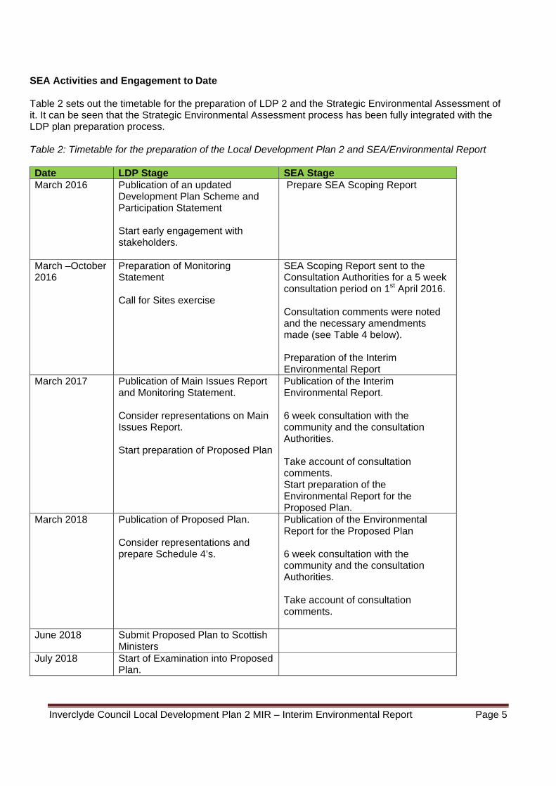
SEA Activities and Engagement to Date Table 2 sets out the timetable for the preparation of LDP 2 and the Strategic Environmental Assessment of it. It can be seen that the Strategic Environmental Assessment process has been fully integrated with the LDP plan preparation process. Table 2: Timetable for the preparation of the Local Development Plan 2 and SEA/Environmental Report
Date LDP Stage SEA Stage March 2016 Publication of an updated
Development Plan Scheme and Participation Statement Start early engagement with stakeholders.
Prepare SEA Scoping Report
March –October 2016
Preparation of Monitoring Statement Call for Sites exercise
SEA Scoping Report sent to the Consultation Authorities for a 5 week consultation period on 1st April 2016. Consultation comments were noted and the necessary amendments made (see Table 4 below). Preparation of the Interim Environmental Report
March 2017 Publication of Main Issues Report and Monitoring Statement. Consider representations on Main Issues Report. Start preparation of Proposed Plan
Publication of the Interim Environmental Report. 6 week consultation with the community and the consultation Authorities. Take account of consultation comments. Start preparation of the Environmental Report for the Proposed Plan.
March 2018 Publication of Proposed Plan. Consider representations and prepare Schedule 4’s.
Publication of the Environmental Report for the Proposed Plan 6 week consultation with the community and the consultation Authorities. Take account of consultation comments.
June 2018 Submit Proposed Plan to Scottish Ministers
July 2018 Start of Examination into Proposed Plan.
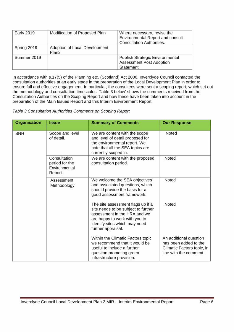
Inverclyde Council Local Development Plan 2 MIR – Interim Environmental Report Page 6
Early 2019 Modification of Proposed Plan Where necessary, revise the Environmental Report and consult Consultation Authorities.
Spring 2019 Adoption of Local Development Plan2
Summer 2019 Publish Strategic Environmental Assessment Post Adoption Statement
In accordance with s.17(5) of the Planning etc. (Scotland) Act 2006, Inverclyde Council contacted the consultation authorities at an early stage in the preparation of the Local Development Plan in order to ensure full and effective engagement. In particular, the consultees were sent a scoping report, which set out the methodology and consultation timescales. Table 3 below’ shows the comments received from the Consultation Authorities on the Scoping Report and how these have been taken into account in the preparation of the Main Issues Report and this Interim Environment Report. Table 3 Consultation Authorities Comments on Scoping Report
Organisation Issue Summary of Comments Our Response
SNH Scope and level of detail.
We are content with the scope and level of detail proposed for the environmental report. We note that all the SEA topics are currently scoped in.
Noted
Consultation period for the Environmental Report
We are content with the proposed consultation period.
Noted
Assessment Methodology
We welcome the SEA objectives and associated questions, which should provide the basis for a good assessment framework. The site assessment flags up if a site needs to be subject to further assessment in the HRA and we are happy to work with you to identify sites which may need further appraisal. Within the Climatic Factors topic we recommend that it would be useful to include a further question promoting green infrastructure provision.
Noted Noted
An additional question has been added to the Climatic Factors topic, in line with the comment.
Inverclyde Council Local Development Plan 2 MIR – Interim Environmental Report Page 7
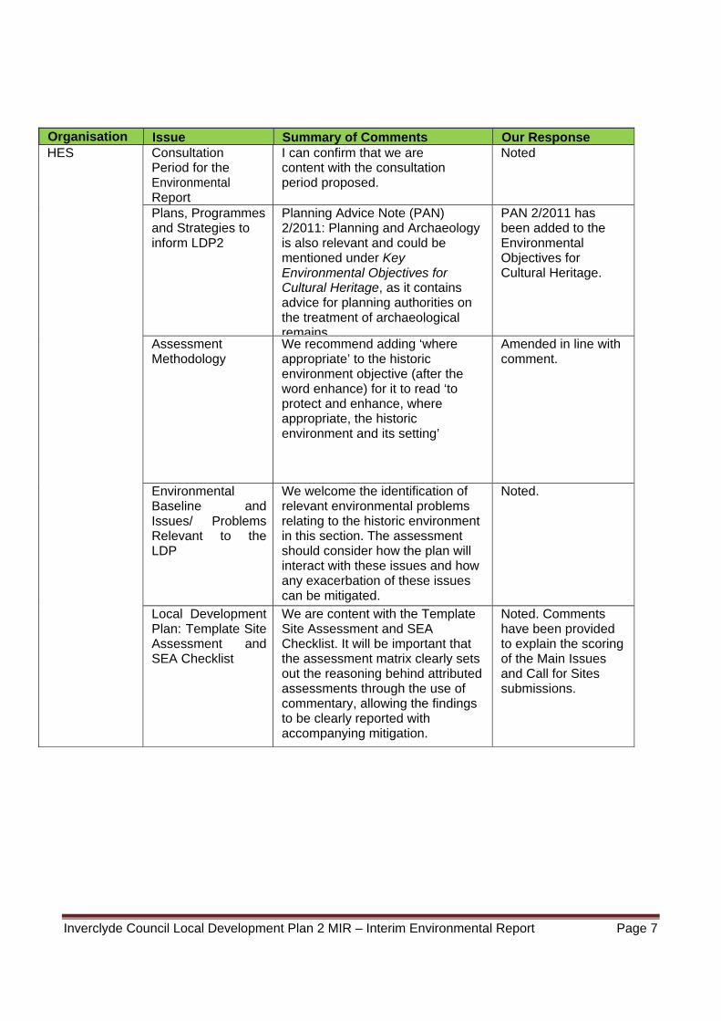
Organisation Issue Summary of Comments Our Response HES
Consultation Period for the Environmental Report
I can confirm that we are content with the consultation period proposed.
Noted
Plans, Programmes and Strategies to inform LDP2
Planning Advice Note (PAN) 2/2011: Planning and Archaeology is also relevant and could be mentioned under Key Environmental Objectives for Cultural Heritage, as it contains advice for planning authorities on the treatment of archaeological remains.
PAN 2/2011 has been added to the Environmental Objectives for Cultural Heritage.
Assessment Methodology
We recommend adding ‘where appropriate’ to the historic environment objective (after the word enhance) for it to read ‘to protect and enhance, where appropriate, the historic environment and its setting’
Amended in line with comment.
Environmental Baseline and Issues/ Problems Relevant to the LDP
We welcome the identification of relevant environmental problems relating to the historic environment in this section. The assessment should consider how the plan will interact with these issues and how any exacerbation of these issues can be mitigated.
Noted.
Local Development Plan: Template Site Assessment and SEA Checklist
We are content with the Template Site Assessment and SEA Checklist. It will be important that the assessment matrix clearly sets out the reasoning behind attributed assessments through the use of commentary, allowing the findings to be clearly reported with accompanying mitigation.
Noted. Comments have been provided to explain the scoring of the Main Issues and Call for Sites submissions.
Inverclyde Council Local Development Plan 2 MIR – Interim Environmental Report Page 8
Organisation Issue Summary of Comments Our Response SEPA Relationship with
Other PPS Some of the PPS included have themselves been subject to SEA. Where this is the case you may find it useful to prepare a summary of the key SEA findings that may be relevant to the Inverclyde Local Development Plan 2. This may assist you with data sources and environmental baseline information and also ensure the current SEA picks up environmental issues or mitigation actions which may have been identified elsewhere.
Noted
Environmental Baseline Information SEPA holds significant amounts of
environmental data, much of which is on SEPA’s website. This may be of interest to you in preparing the ER. Additional local information may also be available from our Access to Information unit.
Other sources of data are referenced in our ‘Standing Advice for Responsible Authorities on Strategic Environmental Assessment (SEA) Scoping Consultations’.
Noted
Environmental Problems
The environmental problems described generally highlight the main issues of relevance for the SEA topics within our remit.
Noted
Alternatives Any reasonable alternatives identified during the preparation of the plan should be assessed as part of the SEA process and the findings of the assessment should inform the choice of the preferred option. This should be documented in the Environmental Report.
All the preferred and alternative options identified in the MIR have been fully assessed in this Environmental Report.
Scoping In/Out of Issues
We agree that all environmental topics should be scoped into the assessment.
Noted
Inverclyde Council Local Development Plan 2 MIR – Interim Environmental Report Page 9
Organisation Issue Summary of Comments Our Response Assessment
Methodology Where it is expected that other plans, programmes or strategies are better placed to undertake more detailed assessment of environmental effects this should be clearly set out in the Environmental Report.
Noted
We would expect all aspects of the PPS which could have significant. effects to be assessed.
The Main Issues Report, and the ER of it, focuses on the ‘main issues’ which need to be addressed in LDP2. All aspects of LDP2 will be fully assessed at the Proposed Plan stage.
It would also be helpful to set out assumptions that are made during the assessment and difficulties and limitations encountered.
Noted. Noted. Comments have been provided to explain the scoring of the Main Issues and Call for Sites submissions.
We are content with the proposed detailed assessment matrix and particularly welcome the commentary box to fully explain the rationale behind the assessment results. We also welcome the link between effects and mitigation / enhancement measures in the proposed assessment framework and the consideration of mitigation of impacts.
Noted
We are content with the proposed SEA objectives to be used in the assessment. However it may be helpful under the Soil objective to consider whether disturbance to carbon rich soils, in particular peat has been minimized.
Noted. The soil objective has been amended to considered impact on carbon rich soils.
Inverclyde Council Local Development Plan 2 MIR – Interim Environmental Report Page 10
Mitigation We would encourage you to use the assessment as a way to improve the environmental performance of individual aspects of the final option; hence we support proposals for enhancement of positive effects as well as mitigation of negative effects.
Noted
It is useful to show the link between potential effects and proposed mitigation / enhancement measures in the assessment framework.
Noted – The assessment matrix shows any identified mitigation measures next to the effects which they seek to address.
We would encourage you to be very clear in the Environmental Report about mitigation measures which are proposed as a result of the assessment. These should follow the mitigation hierarchy (avoid, reduce, remedy or compensate).
Noted
The Environmental Report should identify any changes made to the plan as a result of the SEA.
Noted
Where the mitigation proposed does not relate to modification to the plan itself then it would be extremely helpful to set out the proposed mitigation measures in a way that clearly identifies: (1) the measures required, (2) when they would be required and (3) who will be required to implement them. The inclusion of a summary table in the Environmental Report such as that presented below will help to track progress on mitigation through the monitoring process.
Noted
Monitoring It would be helpful if the Environmental Report included a description of the measures envisaged to monitor the significant environmental effects of the plan.
Noted – A Monitoring Framework is provided in Table 8
Consultation Period
We are satisfied with the proposal for a 6 week consultation period for the Environmental Report.
Noted
Outcomes of the Scoping
We would find it helpful if the Environmental Report included a summary of the scoping outcomes and how comments from the Consultation Authorities were taken into account.
Noted – A summary of the comments made on the Scoping Report is set out in Table 4.
Inverclyde Council Local Development Plan 2 MIR – Interim Environmental Report Page 11
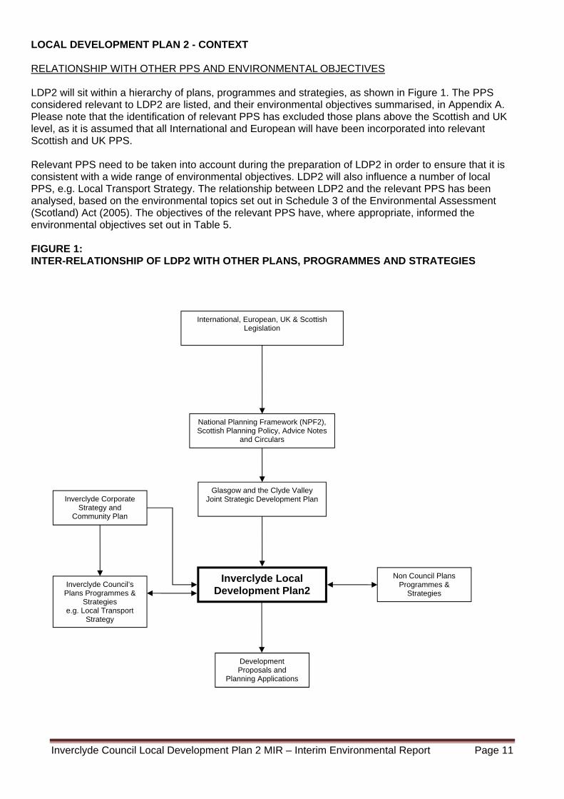
LOCAL DEVELOPMENT PLAN 2 - CONTEXT RELATIONSHIP WITH OTHER PPS AND ENVIRONMENTAL OBJECTIVES LDP2 will sit within a hierarchy of plans, programmes and strategies, as shown in Figure 1. The PPS considered relevant to LDP2 are listed, and their environmental objectives summarised, in Appendix A. Please note that the identification of relevant PPS has excluded those plans above the Scottish and UK level, as it is assumed that all International and European will have been incorporated into relevant Scottish and UK PPS. Relevant PPS need to be taken into account during the preparation of LDP2 in order to ensure that it is consistent with a wide range of environmental objectives. LDP2 will also influence a number of local PPS, e.g. Local Transport Strategy. The relationship between LDP2 and the relevant PPS has been analysed, based on the environmental topics set out in Schedule 3 of the Environmental Assessment (Scotland) Act (2005). The objectives of the relevant PPS have, where appropriate, informed the environmental objectives set out in Table 5. FIGURE 1: INTER-RELATIONSHIP OF LDP2 WITH OTHER PLANS, PROGRAMMES AND STRATEGIES
Inverclyde Council’s Plans Programmes &
Strategies e.g. Local Transport
Strategy
International, European, UK & Scottish Legislation
National Planning Framework (NPF2), Scottish Planning Policy, Advice Notes
and Circulars
Inverclyde Local Development Plan2
Glasgow and the Clyde Valley Joint Strategic Development Plan
Non Council Plans Programmes &
Strategies
Inverclyde Corporate Strategy and
Community Plan
Development Proposals and
Planning Applications
Inverclyde Council Local Development Plan 2 MIR – Interim Environmental Report Page 12
Environmental Baseline and Issues/Problems Relevant to the LDP
To enable an accurate assessment of what effects LDP2 could have, a reliable picture of the current
state of the environment and the environmental issues/problems relevant to LDP2 is required. An environmental baseline was prepared to inform the scoping report, particularly the identification of the objectives and assessment questions set out in Table 5. This baseline has been updated following the preparation of a Monitoring Statement and consultation with relevant stakeholders (See Appendix B), and used to inform the environmental assessment of LDP2 - Main Issues Report. An environmental constraints map has also been used in the analysis of site specific proposals and policy implications (See Appendix F).
Likely Evolution of the Environment without the PPS It is a Scottish Government requirement that LDP’s should be reviewed every 5 years, in order to take account of, and align with, changing policy objectives, legislation, and local circumstances. If LDP2 was not adopted by August 2019, development proposals would continue to be considered against the current LDP (2014), which may not fully align with the planning and local context of 2019. This could lead to unsustainable development taking place, with adverse impacts on the environment of Inverclyde. SEA METHOLOGY Scoping In/Out of SEA Issues To aid proportionality, only those SEA environmental topics on which the plan is likely to have significant environmental effects, should be scoped into the environmental assessment. Although there is no statutory definition of ‘significant’ in the context of SEA, Schedule 2 of the Environmental Assessment (Scotland) Act (2005) provides guidance on the criteria that should be used in determining likely significance. Referring to that guidance, the Council has used the following criteria to identify those environmental topics which require to be scoped in.
the value and vulnerability of the area likely to be affected, including areas with a
recognised international, national, strategic or local protection status; the scale and spatial extent of the effects; the duration of the impact (short, medium or long term); the reversibility of the impact; and the potential for significant cumulative effects.
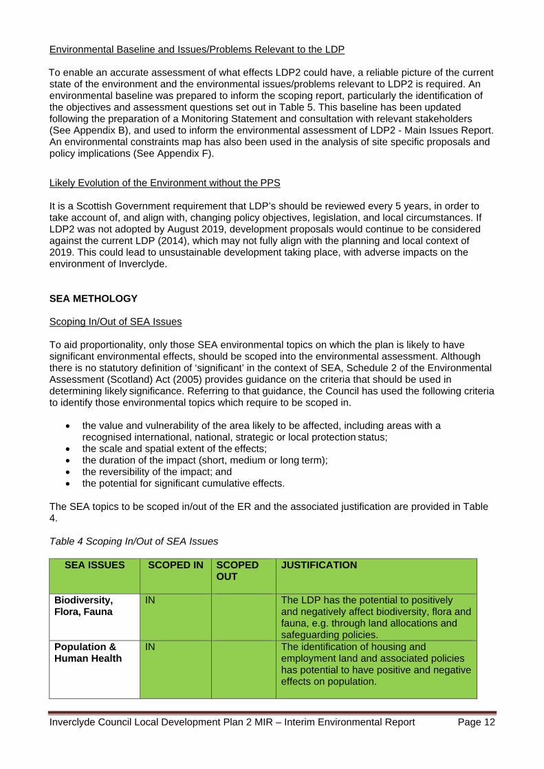
The SEA topics to be scoped in/out of the ER and the associated justification are provided in Table 4. Table 4 Scoping In/Out of SEA Issues
SEA ISSUES SCOPED IN
SCOPED OUT
JUSTIFICATION
Biodiversity, Flora, Fauna
IN The LDP has the potential to positively and negatively affect biodiversity, flora and fauna, e.g. through land allocations and safeguarding policies.
Population & Human Health
IN The identification of housing and employment land and associated policies has potential to have positive and negative effects on population.
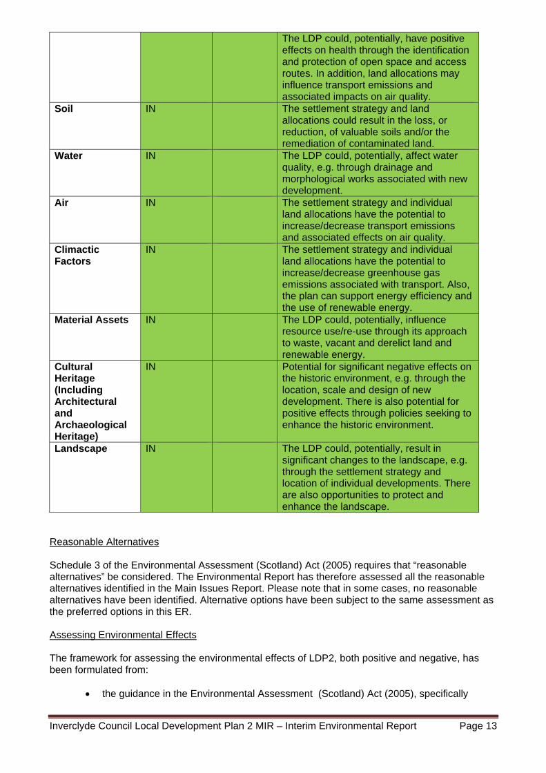
Inverclyde Council Local Development Plan 2 MIR – Interim Environmental Report Page 13
The LDP could, potentially, have positive effects on health through the identification and protection of open space and access routes. In addition, land allocations may influence transport emissions and associated impacts on air quality.
Soil IN The settlement strategy and land allocations could result in the loss, or reduction, of valuable soils and/or the remediation of contaminated land.
Water IN The LDP could, potentially, affect water quality, e.g. through drainage and morphological works associated with new development.
Air IN The settlement strategy and individual land allocations have the potential to increase/decrease transport emissions and associated effects on air quality.
Climactic Factors
IN The settlement strategy and individual land allocations have the potential to increase/decrease greenhouse gas emissions associated with transport. Also, the plan can support energy efficiency and the use of renewable energy.
Material Assets IN The LDP could, potentially, influence resource use/re-use through its approach to waste, vacant and derelict land and renewable energy.
Cultural Heritage (Including Architectural and Archaeological Heritage)
IN Potential for significant negative effects on the historic environment, e.g. through the location, scale and design of new development. There is also potential for positive effects through policies seeking to enhance the historic environment.
Landscape IN The LDP could, potentially, result in significant changes to the landscape, e.g. through the settlement strategy and location of individual developments. There are also opportunities to protect and enhance the landscape.
Reasonable Alternatives Schedule 3 of the Environmental Assessment (Scotland) Act (2005) requires that “reasonable alternatives” be considered. The Environmental Report has therefore assessed all the reasonable alternatives identified in the Main Issues Report. Please note that in some cases, no reasonable alternatives have been identified. Alternative options have been subject to the same assessment as the preferred options in this ER. Assessing Environmental Effects The framework for assessing the environmental effects of LDP2, both positive and negative, has been formulated from:
the guidance in the Environmental Assessment (Scotland) Act (2005), specifically
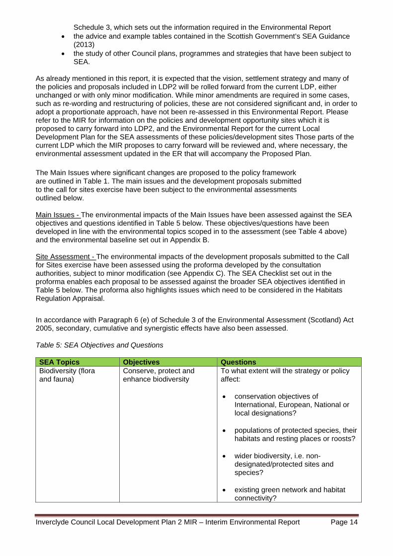
Inverclyde Council Local Development Plan 2 MIR – Interim Environmental Report Page 14
Schedule 3, which sets out the information required in the Environmental Report the advice and example tables contained in the Scottish Government’s SEA Guidance
(2013) the study of other Council plans, programmes and strategies that have been subject to
SEA. As already mentioned in this report, it is expected that the vision, settlement strategy and many of the policies and proposals included in LDP2 will be rolled forward from the current LDP, either unchanged or with only minor modification. While minor amendments are required in some cases, such as re-wording and restructuring of policies, these are not considered significant and, in order to adopt a proportionate approach, have not been re-assessed in this Environmental Report. Please refer to the MIR for information on the policies and development opportunity sites which it is proposed to carry forward into LDP2, and the Environmental Report for the current Local Development Plan for the SEA assessments of these policies/development sites Those parts of the current LDP which the MIR proposes to carry forward will be reviewed and, where necessary, the environmental assessment updated in the ER that will accompany the Proposed Plan.
The Main Issues where significant changes are proposed to the policy framework are outlined in Table 1. The main issues and the development proposals submitted to the call for sites exercise have been subject to the environmental assessments outlined below.
Main Issues - The environmental impacts of the Main Issues have been assessed against the SEA objectives and questions identified in Table 5 below. These objectives/questions have been developed in line with the environmental topics scoped in to the assessment (see Table 4 above) and the environmental baseline set out in Appendix B.
Site Assessment - The environmental impacts of the development proposals submitted to the Call for Sites exercise have been assessed using the proforma developed by the consultation authorities, subject to minor modification (see Appendix C). The SEA Checklist set out in the proforma enables each proposal to be assessed against the broader SEA objectives identified in Table 5 below. The proforma also highlights issues which need to be considered in the Habitats Regulation Appraisal.
In accordance with Paragraph 6 (e) of Schedule 3 of the Environmental Assessment (Scotland) Act 2005, secondary, cumulative and synergistic effects have also been assessed. Table 5: SEA Objectives and Questions SEA Topics Objectives Questions Biodiversity (flora and fauna)
Conserve, protect and enhance biodiversity
To what extent will the strategy or policy affect: conservation objectives of
International, European, National or local designations?
populations of protected species, their habitats and resting places or roosts?
wider biodiversity, i.e. non-
designated/protected sites and species?
existing green network and habitat
connectivity?
Inverclyde Council Local Development Plan 2 MIR – Interim Environmental Report Page 15
opportunities for enhancement or
expansion of the green network and wider habitat connectivity?
the protection and enhancement of
trees, woodland and hedges? the role of watercourses as valuable
wildlife habitats/corridors? Soil Protect soil quality,
particularly carbon rich soils and prime agricultural land, and remediate contaminated land.
To what extent will the strategy or policy affect: greenfield land
carbon rich soils (e.g. peat) and prime
agricultural land through soil sealing and compaction
the release of soil contaminants during
construction, cleaning or redevelopment?
contaminated land?
Water Maintain and enhance water quality/ecological status, safeguard the functional floodplain and manage and reduce flood risk.
To what extent will the strategy or policy affect: the ecological status of identified water
bodies, through: a) water-borne pollution (e.g.
sewage discharge b) Water abstraction
surface water run-off/SUDS
morphological alterations flood risk in the local and/or wider
areas? Landscape Safeguard landscape
designations, landscape character, the setting of settlements, and local distinctiveness.
To what extent will the strategy or policy affect: landscape designations
the landscape setting of settlements? valuable landscape or geological
features? Cultural Heritage Protect and enhance the
historic environment and its setting
To what extent will the strategy or policy affect: listed buildings, scheduled ancient
monuments, archaeological sites, Conservation Areas and Gardens and Designed Landscapes?
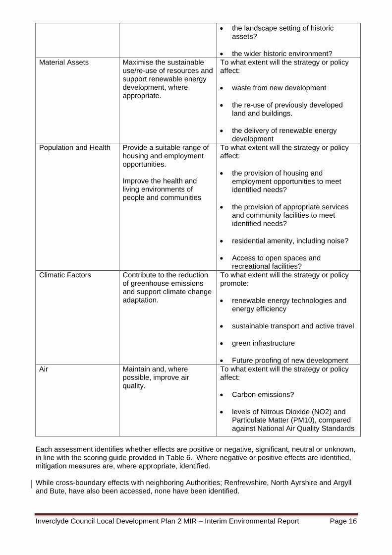
Inverclyde Council Local Development Plan 2 MIR – Interim Environmental Report Page 16
the landscape setting of historic assets?
the wider historic environment?
Material Assets Maximise the sustainable use/re-use of resources and support renewable energy development, where appropriate.
To what extent will the strategy or policy affect: waste from new development
the re-use of previously developed
land and buildings. the delivery of renewable energy
development Population and Health Provide a suitable range of
housing and employment opportunities. Improve the health and living environments of people and communities
To what extent will the strategy or policy affect: the provision of housing and
employment opportunities to meet identified needs?
the provision of appropriate services and community facilities to meet identified needs?
residential amenity, including noise? Access to open spaces and
recreational facilities? Climatic Factors Contribute to the reduction
of greenhouse emissions and support climate change adaptation.
To what extent will the strategy or policy promote: renewable energy technologies and
energy efficiency
sustainable transport and active travel green infrastructure Future proofing of new development
Air Maintain and, where possible, improve air quality.
To what extent will the strategy or policy affect: Carbon emissions?
levels of Nitrous Dioxide (NO2) and
Particulate Matter (PM10), compared against National Air Quality Standards
Each assessment identifies whether effects are positive or negative, significant, neutral or unknown, in line with the scoring guide provided in Table 6. Where negative or positive effects are identified, mitigation measures are, where appropriate, identified. While cross-boundary effects with neighboring Authorities; Renfrewshire, North Ayrshire and Argyll and Bute, have also been accessed, none have been identified.
Inverclyde Council Local Development Plan 2 MIR – Interim Environmental Report Page 17
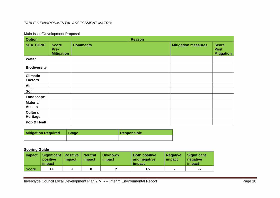
The matrix provided in Table 6 has been used to summarise the find of assessment findings for each Main Issues/development proposal. The matrix, which should be read either in conjunction with Table 5 (policies) or the site assessment template (Appendix C), identifies a pre-mitigation score, appropriate mitigation measures where necessary, and a post mitigation score. The comments column explains the reasoning which underpins the scoring, particularly in relation to positive/negative impacts. Where a number of neutral scores are identified, a single comment/explanation covering these scores may be provided.
The assessment of the main issues where change is proposed and the development proposals submitted to the Call for Sites exercise, policies and proposals is supported by an Environmental Constraints Map (Appendix F) and Environmental Baseline (Appendix B).
Inverclyde Council Local Development Plan 2 MIR – Interim Environmental Report Page 18
TABLE 6 ENVIRONMENTAL ASSESSMENT MATRIX
Main Issue/Development Proposal
Option Reason
SEA TOPIC Score Pre-Mitigation
Comments Mitigation measures Score Post Mitigation
Water
Biodiversity
Climatic Factors
Air
Soil
Landscape
Material Assets
Cultural Heritage
Pop & Healt
Mitigation Required Stage Responsible
Scoring Guide
Impact Significant positive impact
Positive impact
Neutral impact
Unknown impact
Both positive and negative impact
Negative impact
Significant negative impact
Score ++ + 0 ? +/- - --
Inverclyde Council Local Development Plan 2 MIR – Interim Environmental Report Page 19
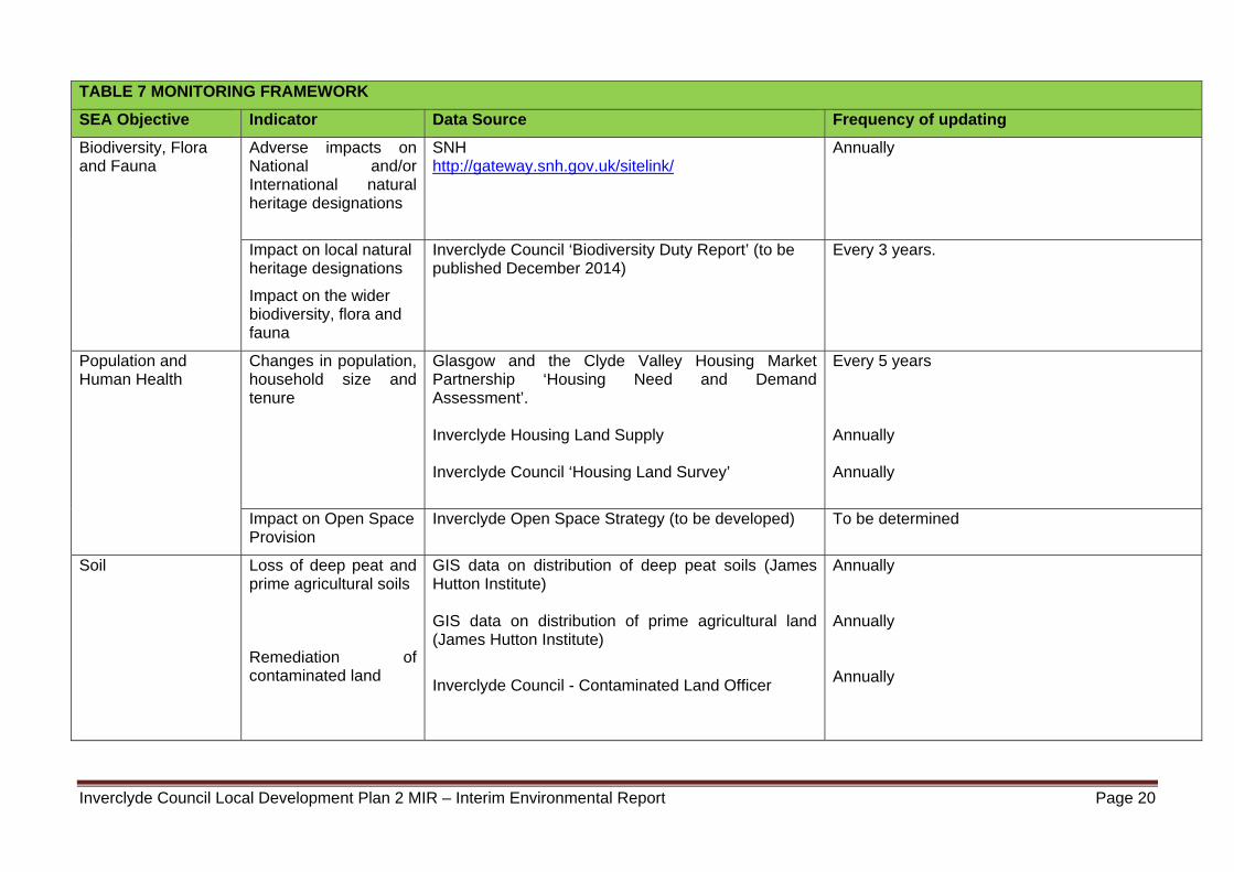
Monitoring Programme To comply with section 19 of the Environmental Assessment (Scotland) Act 2005, and as set out in Schedule 3, the ER is required to include “a description of the measures envisaged concerning monitoring” of the significant environmental effects of the implementation of the Local Development Plan. A Monitoring Framework is provided in Table 7.
Inverclyde Council Local Development Plan 2 MIR – Interim Environmental Report Page 20
TABLE 7 MONITORING FRAMEWORK
SEA Objective Indicator Data Source Frequency of updating
Biodiversity, Flora and Fauna
Adverse impacts on National and/or International natural heritage designations
SNH http://gateway.snh.gov.uk/sitelink/
Annually
Impact on local natural heritage designations
Impact on the wider biodiversity, flora and fauna
Inverclyde Council ‘Biodiversity Duty Report’ (to be published December 2014)
Every 3 years.
Population and Human Health
Changes in population, household size and tenure
Glasgow and the Clyde Valley Housing Market Partnership ‘Housing Need and Demand Assessment’. Inverclyde Housing Land Supply Inverclyde Council ‘Housing Land Survey’
Every 5 years Annually Annually
Impact on Open Space Provision
Inverclyde Open Space Strategy (to be developed)
To be determined
Soil Loss of deep peat and prime agricultural soils
Remediation of contaminated land
GIS data on distribution of deep peat soils (James Hutton Institute) GIS data on distribution of prime agricultural land (James Hutton Institute)
Inverclyde Council - Contaminated Land Officer
Annually Annually Annually
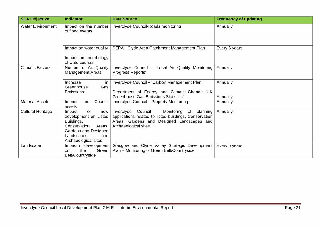
Inverclyde Council Local Development Plan 2 MIR – Interim Environmental Report Page 21
SEA Objective Indicator Data Source Frequency of updating
Water Environment Impact on the number of flood events
Inverclyde Council-Roads monitoring
Annually
Impact on water quality Impact on morphology of watercourses
SEPA - Clyde Area Catchment Management Plan
Every 6 years
Climatic Factors Number of Air Quality Management Areas
Inverclyde Council – ‘Local Air Quality Monitoring Progress Reports’
Annually
Increase in Greenhouse Gas Emissions
Inverclyde Council – ‘Carbon Management Plan’ Department of Energy and Climate Change ‘UK Greenhouse Gas Emissions Statistics’
Annually Annually
Material Assets Impact on Council assets
Inverclyde Council – Property Monitoring Annually
Cultural Heritage Impact of new development on Listed Buildings, Conservation Areas, Gardens and Designed Landscapes and Archaeological sites
Inverclyde Council - Monitoring of planning applications related to listed buildings, Conservation Areas, Gardens and Designed Landscapes and Archaeological sites.
Annually
Landscape Impact of development on the Green Belt/Countryside
Glasgow and Clyde Valley Strategic Development Plan – Monitoring of Green Belt/Countryside
Every 5 years
22
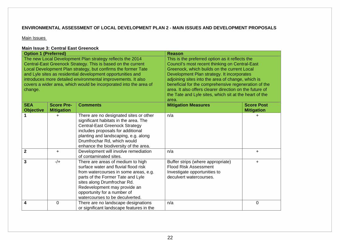
ENVIRONMENTAL ASSESSMENT OF LOCAL DEVELOPMENT PLAN 2 - MAIN ISSUES AND DEVELOPMENT PROPOSALS
Main Issues Main Issue 3: Central East Greenock Option 1 (Preferred) Reason The new Local Development Plan strategy reflects the 2014 Central-East Greenock Strategy. This is based on the current Local Development Plan strategy, but confirms the former Tate and Lyle sites as residential development opportunities and introduces more detailed environmental improvements. It also covers a wider area, which would be incorporated into the area of change.
This is the preferred option as it reflects the Council’s most recent thinking on Central-East Greenock, which builds on the current Local Development Plan strategy. It incorporates adjoining sites into the area of change, which is beneficial for the comprehensive regeneration of the area. It also offers clearer direction on the future of the Tate and Lyle sites, which sit at the heart of the area.
SEA Objective
Score Pre-Mitigation
Comments Mitigation Measures Score Post Mitigation
1 + There are no designated sites or other significant habitats in the area. The Central-East Greenock Strategy includes proposals for additional planting and landscaping, e.g. along Drumfrochar Rd, which would enhance the biodiversity of the area.
n/a +
2 + Development will involve remediation of contaminated sites.
n/a +
3 -/+ There are areas of medium to high surface water and fluvial flood risk from watercourses in some areas, e.g. parts of the Former Tate and Lyle sites along Drumfrochar Rd. Redevelopment may provide an opportunity for a number of watercourses to be deculverted.
Buffer strips (where appropriate) Flood Risk Assessment Investigate opportunities to deculvert watercourses.
+
4 0 There are no landscape designations or significant landscape features in the
n/a 0
23
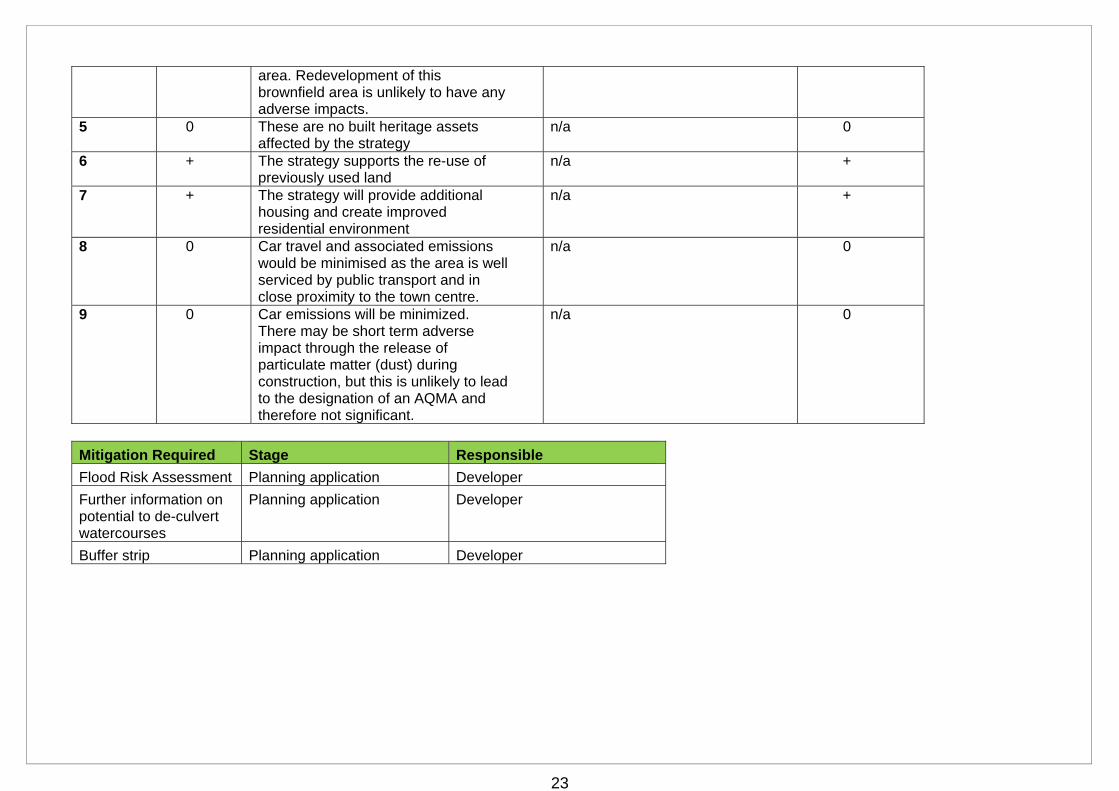
area. Redevelopment of this brownfield area is unlikely to have any adverse impacts.
5 0 These are no built heritage assets affected by the strategy
n/a 0
6 + The strategy supports the re-use of previously used land
n/a +
7 + The strategy will provide additional housing and create improved residential environment
n/a +
8 0 Car travel and associated emissions would be minimised as the area is well serviced by public transport and in close proximity to the town centre.
n/a 0
9 0 Car emissions will be minimized. There may be short term adverse impact through the release of particulate matter (dust) during construction, but this is unlikely to lead to the designation of an AQMA and therefore not significant.
n/a 0
Mitigation Required Stage Responsible
Flood Risk Assessment Planning application Developer
Further information on potential to de-culvert watercourses
Planning application Developer
Buffer strip Planning application Developer
24
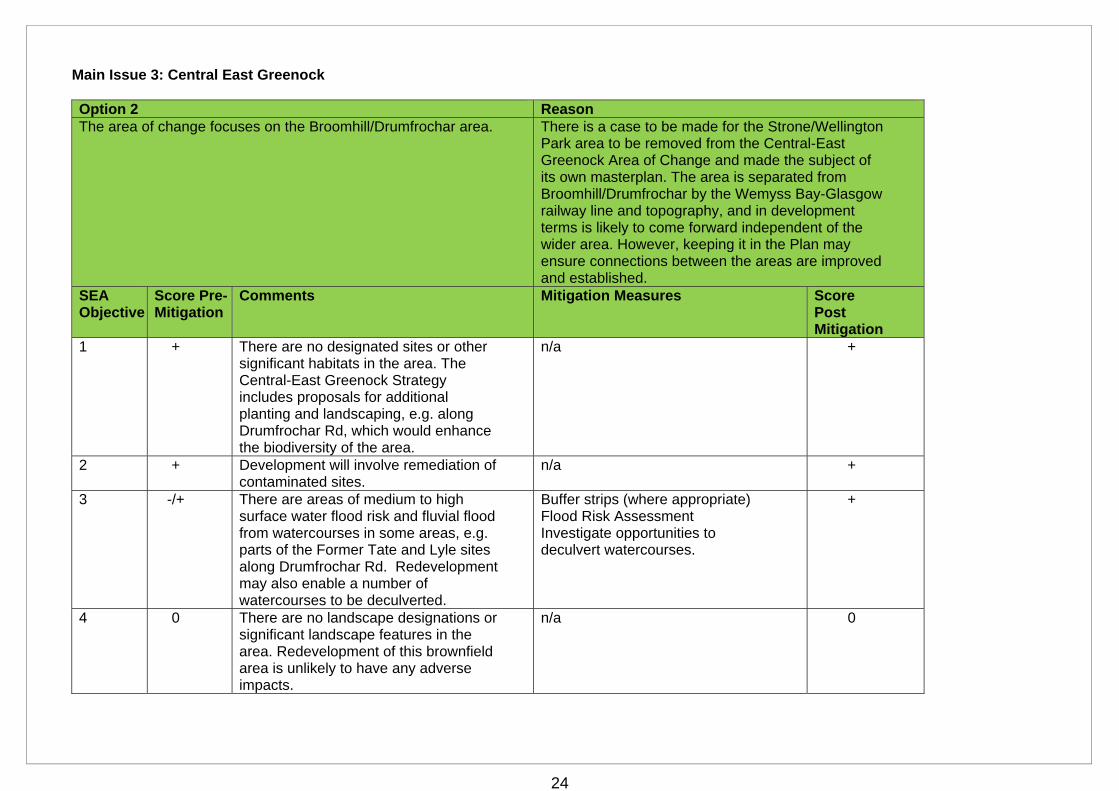
Main Issue 3: Central East Greenock Option 2 Reason The area of change focuses on the Broomhill/Drumfrochar area. There is a case to be made for the Strone/Wellington
Park area to be removed from the Central-East Greenock Area of Change and made the subject of its own masterplan. The area is separated from Broomhill/Drumfrochar by the Wemyss Bay-Glasgow railway line and topography, and in development terms is likely to come forward independent of the wider area. However, keeping it in the Plan may ensure connections between the areas are improved and established.
SEA Objective
Score Pre-Mitigation
Comments Mitigation Measures Score Post Mitigation
1 + There are no designated sites or other significant habitats in the area. The Central-East Greenock Strategy includes proposals for additional planting and landscaping, e.g. along Drumfrochar Rd, which would enhance the biodiversity of the area.
n/a +
2 + Development will involve remediation of contaminated sites.
n/a +
3 -/+ There are areas of medium to high surface water flood risk and fluvial flood from watercourses in some areas, e.g. parts of the Former Tate and Lyle sites along Drumfrochar Rd. Redevelopment may also enable a number of watercourses to be deculverted.
Buffer strips (where appropriate) Flood Risk Assessment Investigate opportunities to deculvert watercourses.
+
4 0 There are no landscape designations or significant landscape features in the area. Redevelopment of this brownfield area is unlikely to have any adverse impacts.
n/a 0
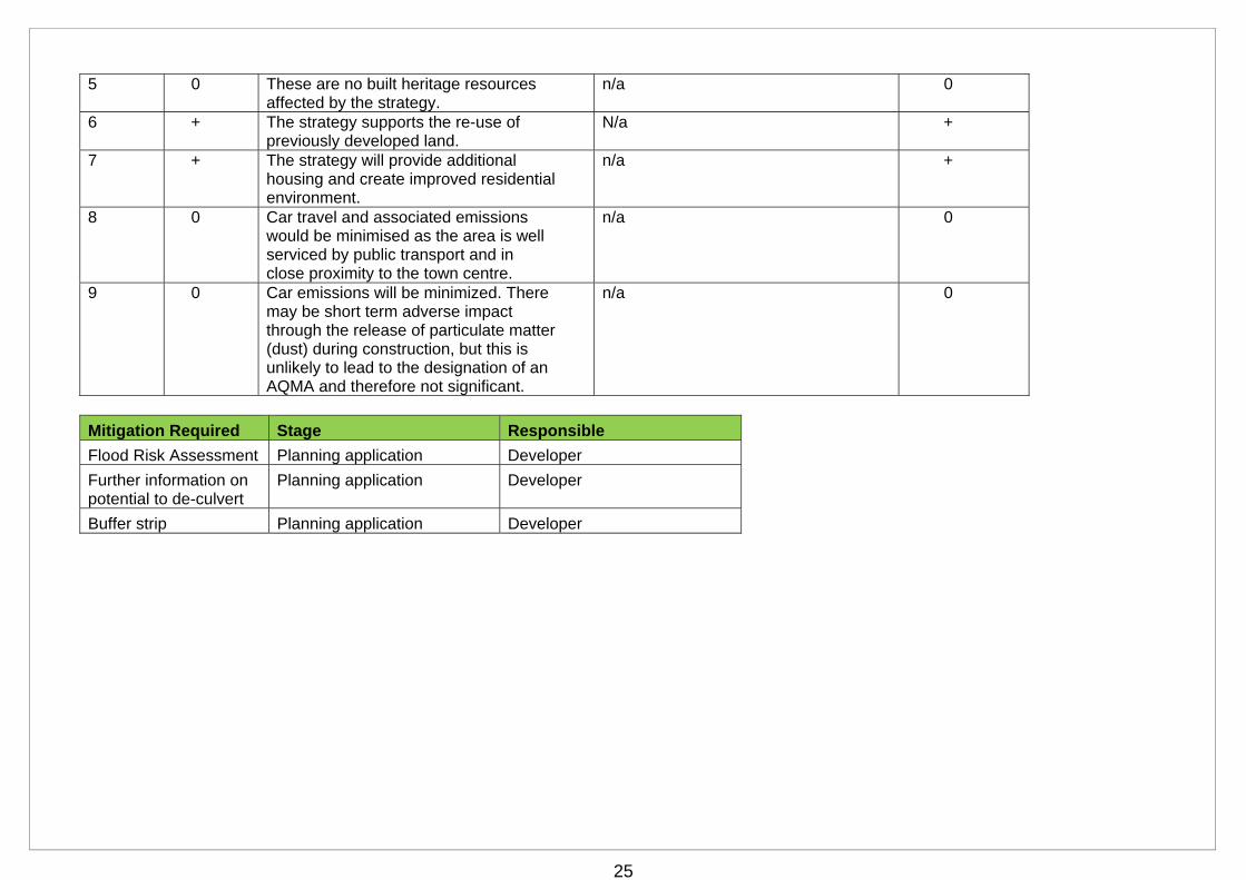
25
5 0 These are no built heritage resources affected by the strategy.
n/a 0
6 + The strategy supports the re-use of previously developed land.
N/a +
7 + The strategy will provide additional housing and create improved residential environment.
n/a +
8 0 Car travel and associated emissions would be minimised as the area is well serviced by public transport and in close proximity to the town centre.
n/a 0
9 0 Car emissions will be minimized. There may be short term adverse impact through the release of particulate matter (dust) during construction, but this is unlikely to lead to the designation of an AQMA and therefore not significant.
n/a 0
Mitigation Required Stage Responsible
Flood Risk Assessment Planning application Developer
Further information on potential to de-culvert
Planning application Developer
Buffer strip Planning application Developer
26
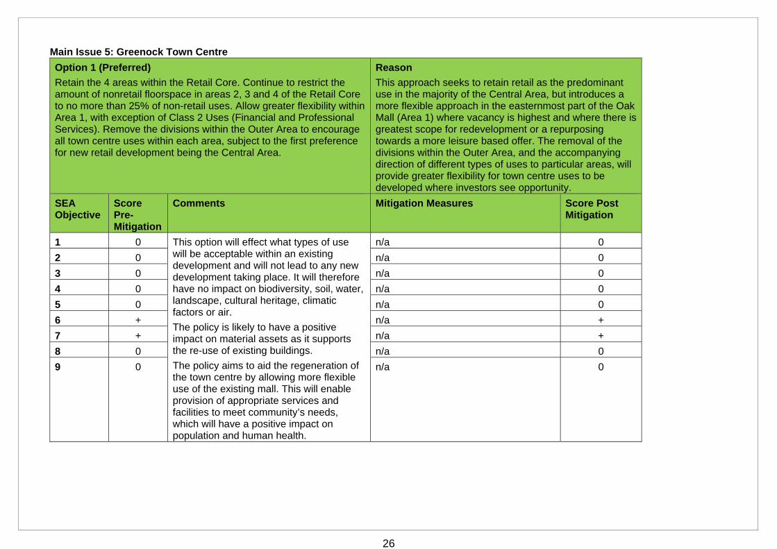
Main Issue 5: Greenock Town Centre
Option 1 (Preferred)
Retain the 4 areas within the Retail Core. Continue to restrict the amount of nonretail floorspace in areas 2, 3 and 4 of the Retail Core to no more than 25% of non-retail uses. Allow greater flexibility within Area 1, with exception of Class 2 Uses (Financial and Professional Services). Remove the divisions within the Outer Area to encourage all town centre uses within each area, subject to the first preference for new retail development being the Central Area.
Reason
This approach seeks to retain retail as the predominant use in the majority of the Central Area, but introduces a more flexible approach in the easternmost part of the Oak Mall (Area 1) where vacancy is highest and where there is greatest scope for redevelopment or a repurposing towards a more leisure based offer. The removal of the divisions within the Outer Area, and the accompanying direction of different types of uses to particular areas, will provide greater flexibility for town centre uses to be developed where investors see opportunity.
SEA Objective
Score Pre-Mitigation
Comments Mitigation Measures Score Post Mitigation
1 0 This option will effect what types of use will be acceptable within an existing development and will not lead to any new development taking place. It will therefore have no impact on biodiversity, soil, water, landscape, cultural heritage, climatic factors or air.
The policy is likely to have a positive impact on material assets as it supports the re-use of existing buildings.
The policy aims to aid the regeneration of the town centre by allowing more flexible use of the existing mall. This will enable provision of appropriate services and facilities to meet community’s needs, which will have a positive impact on population and human health.
n/a 0
2 0 n/a 0
3 0 n/a 0
4 0 n/a 0
5 0 n/a 0
6 + n/a +
7 + n/a +
8 0 n/a 0
9 0 n/a 0
27
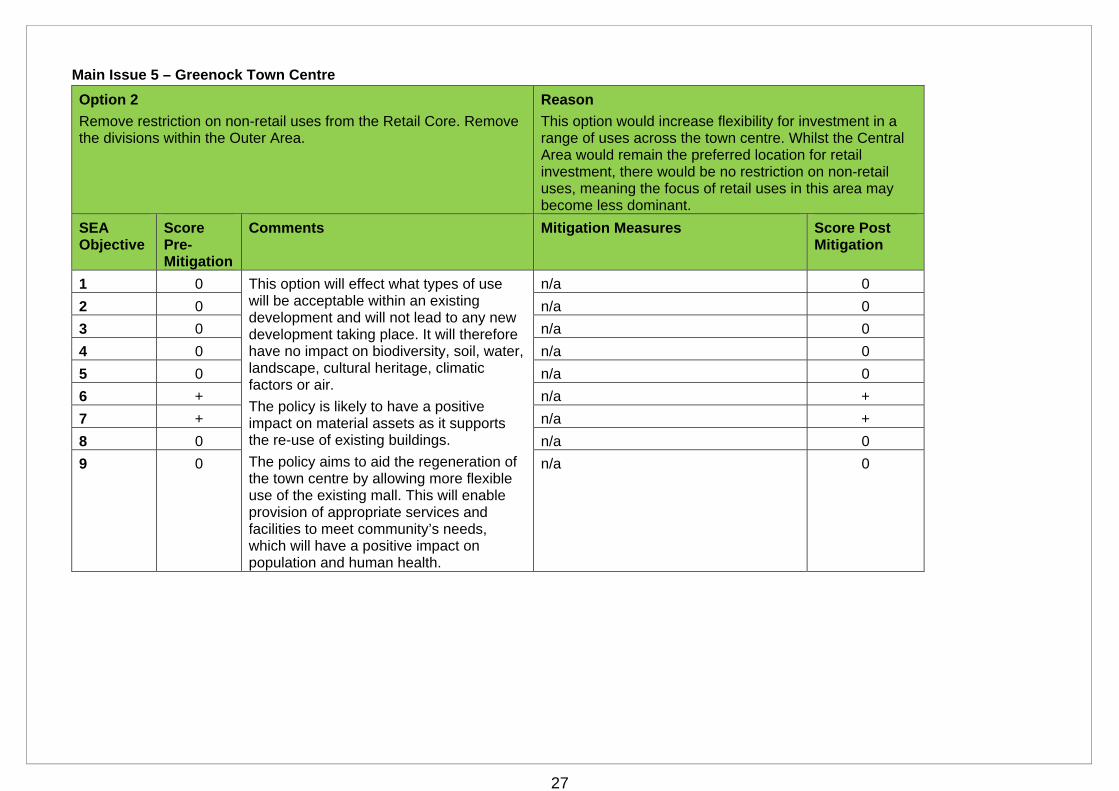
Main Issue 5 – Greenock Town Centre
Option 2
Remove restriction on non-retail uses from the Retail Core. Remove the divisions within the Outer Area.
Reason
This option would increase flexibility for investment in a range of uses across the town centre. Whilst the Central Area would remain the preferred location for retail investment, there would be no restriction on non-retail uses, meaning the focus of retail uses in this area may become less dominant.
SEA Objective
Score Pre-Mitigation
Comments Mitigation Measures Score Post Mitigation
1 0 This option will effect what types of use will be acceptable within an existing development and will not lead to any new development taking place. It will therefore have no impact on biodiversity, soil, water, landscape, cultural heritage, climatic factors or air.
The policy is likely to have a positive impact on material assets as it supports the re-use of existing buildings.
The policy aims to aid the regeneration of the town centre by allowing more flexible use of the existing mall. This will enable provision of appropriate services and facilities to meet community’s needs, which will have a positive impact on population and human health.
n/a 0
2 0 n/a 0
3 0 n/a 0
4 0 n/a 0
5 0 n/a 0
6 + n/a +
7 + n/a +
8 0 n/a 0
9 0 n/a 0
28
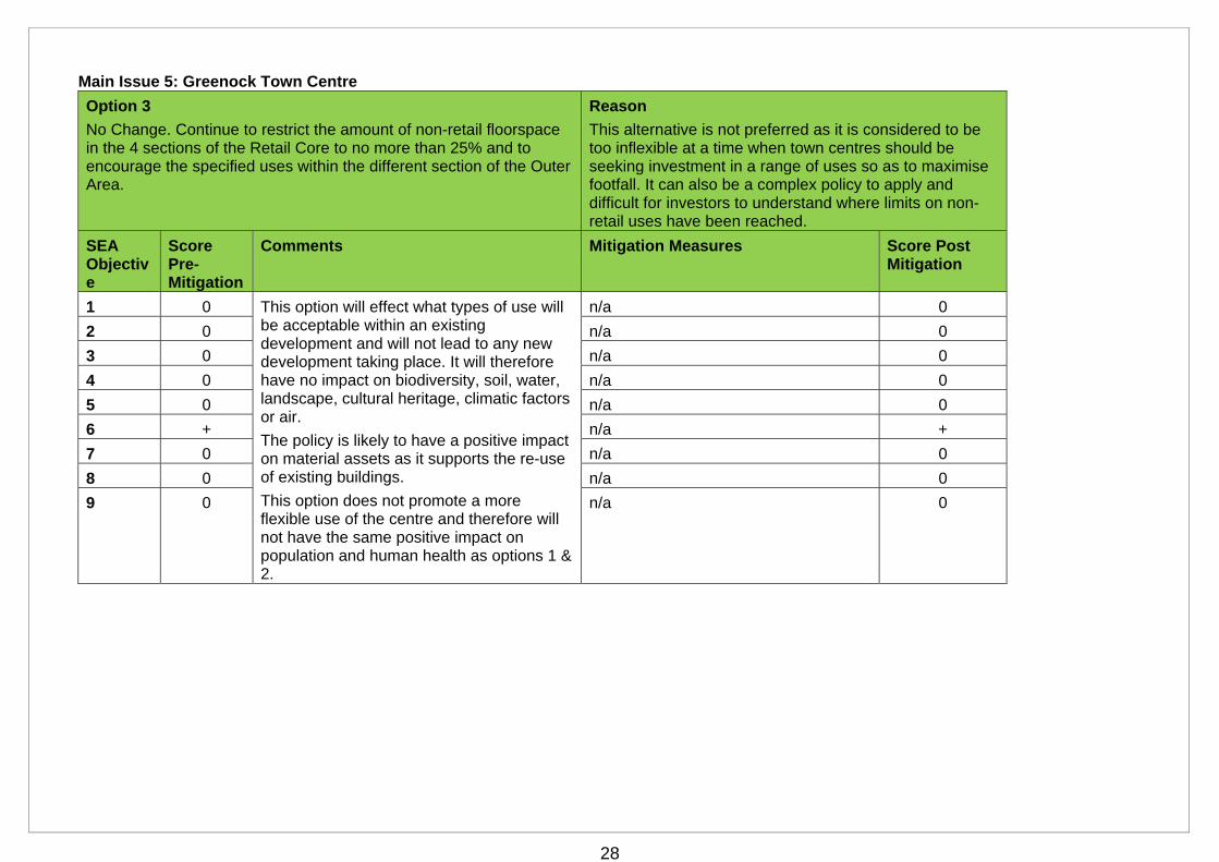
Main Issue 5: Greenock Town Centre
Option 3
No Change. Continue to restrict the amount of non-retail floorspace in the 4 sections of the Retail Core to no more than 25% and to encourage the specified uses within the different section of the Outer Area.
Reason
This alternative is not preferred as it is considered to be too inflexible at a time when town centres should be seeking investment in a range of uses so as to maximise footfall. It can also be a complex policy to apply and difficult for investors to understand where limits on non-retail uses have been reached.
SEA Objective
Score Pre-Mitigation
Comments Mitigation Measures Score Post Mitigation
1 0 This option will effect what types of use will be acceptable within an existing development and will not lead to any new development taking place. It will therefore have no impact on biodiversity, soil, water, landscape, cultural heritage, climatic factors or air.
The policy is likely to have a positive impact on material assets as it supports the re-use of existing buildings.
This option does not promote a more flexible use of the centre and therefore will not have the same positive impact on population and human health as options 1 & 2.
n/a 0
2 0 n/a 0
3 0 n/a 0
4 0 n/a 0
5 0 n/a 0
6 + n/a +
7 0 n/a 0
8 0 n/a 0
9 0 n/a 0
29
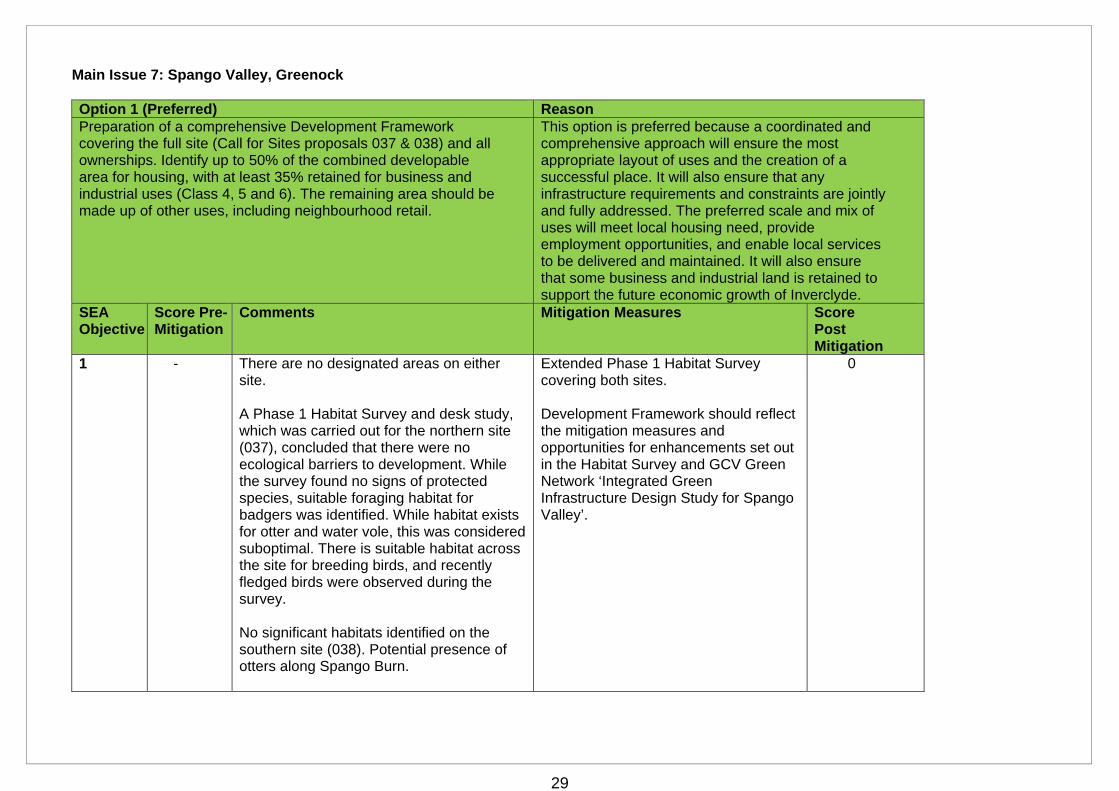
Main Issue 7: Spango Valley, Greenock Option 1 (Preferred) Reason Preparation of a comprehensive Development Framework covering the full site (Call for Sites proposals 037 & 038) and all ownerships. Identify up to 50% of the combined developable area for housing, with at least 35% retained for business and industrial uses (Class 4, 5 and 6). The remaining area should be made up of other uses, including neighbourhood retail.
This option is preferred because a coordinated and comprehensive approach will ensure the most appropriate layout of uses and the creation of a successful place. It will also ensure that any infrastructure requirements and constraints are jointly and fully addressed. The preferred scale and mix of uses will meet local housing need, provide employment opportunities, and enable local services to be delivered and maintained. It will also ensure that some business and industrial land is retained to support the future economic growth of Inverclyde.
SEA Objective
Score Pre-Mitigation
Comments Mitigation Measures Score Post Mitigation
1 - There are no designated areas on either site. A Phase 1 Habitat Survey and desk study, which was carried out for the northern site (037), concluded that there were no ecological barriers to development. While the survey found no signs of protected species, suitable foraging habitat for badgers was identified. While habitat exists for otter and water vole, this was considered suboptimal. There is suitable habitat across the site for breeding birds, and recently fledged birds were observed during the survey. No significant habitats identified on the southern site (038). Potential presence of otters along Spango Burn.
Extended Phase 1 Habitat Survey covering both sites. Development Framework should reflect the mitigation measures and opportunities for enhancements set out in the Habitat Survey and GCV Green Network ‘Integrated Green Infrastructure Design Study for Spango Valley’.
0
30
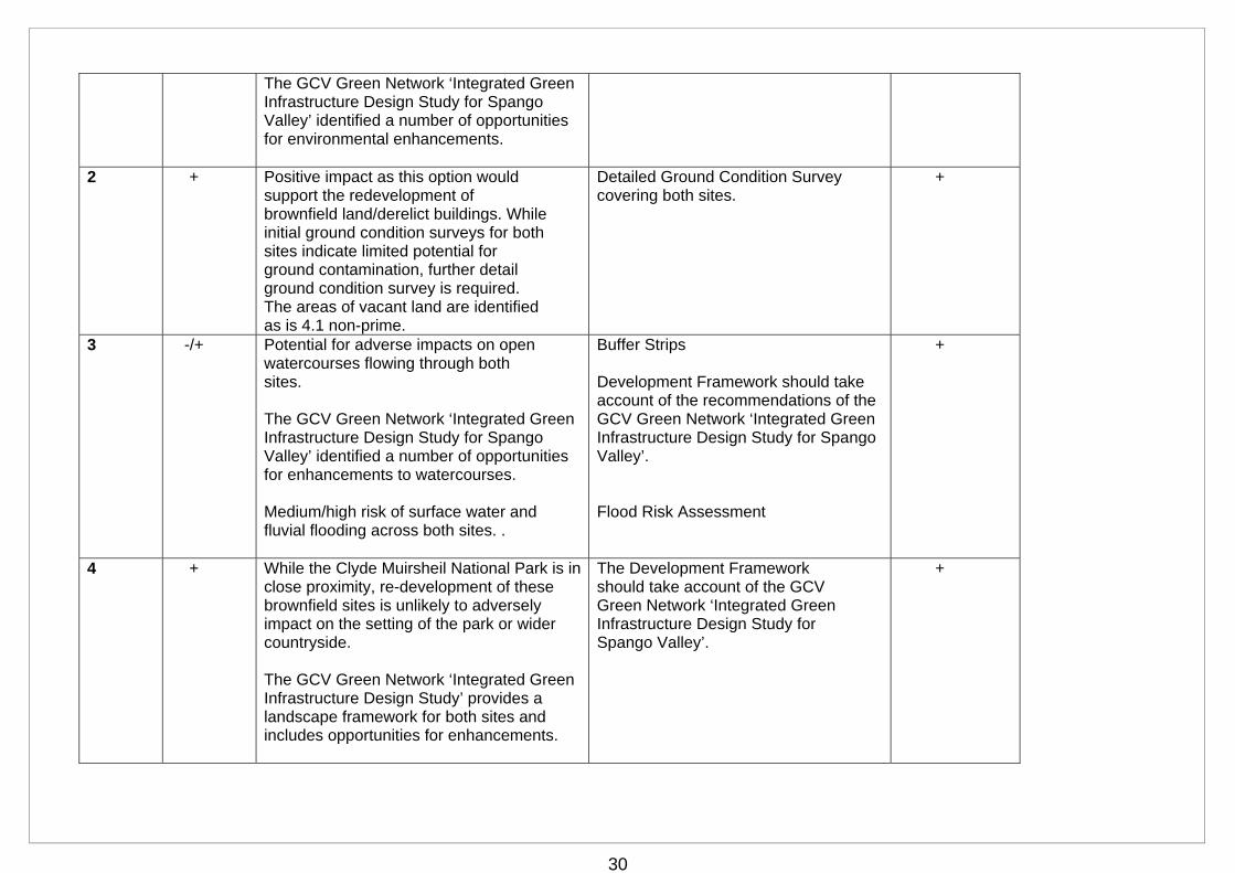
The GCV Green Network ‘Integrated Green Infrastructure Design Study for Spango Valley’ identified a number of opportunities for environmental enhancements.
2 + Positive impact as this option would support the redevelopment of brownfield land/derelict buildings. While initial ground condition surveys for both sites indicate limited potential for ground contamination, further detail ground condition survey is required. The areas of vacant land are identified as is 4.1 non-prime.
Detailed Ground Condition Survey covering both sites.
+
3 -/+ Potential for adverse impacts on open watercourses flowing through both sites. The GCV Green Network ‘Integrated Green Infrastructure Design Study for Spango Valley’ identified a number of opportunities for enhancements to watercourses. Medium/high risk of surface water and fluvial flooding across both sites. .
Buffer Strips Development Framework should take account of the recommendations of the GCV Green Network ‘Integrated Green Infrastructure Design Study for Spango Valley’. Flood Risk Assessment
+
4 + While the Clyde Muirsheil National Park is in close proximity, re-development of these brownfield sites is unlikely to adversely impact on the setting of the park or wider countryside. The GCV Green Network ‘Integrated Green Infrastructure Design Study’ provides a landscape framework for both sites and includes opportunities for enhancements.
The Development Framework should take account of the GCV Green Network ‘Integrated Green Infrastructure Design Study for Spango Valley’.
+
31
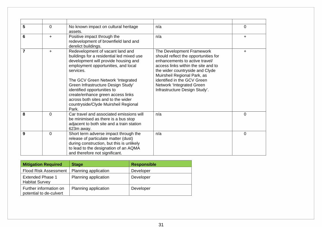
5 0 No known impact on cultural heritage
assets. n/a 0
6 + Positive impact through the redevelopment of brownfield land and derelict buildings.
n/a +
7 + Redevelopment of vacant land and buildings for a residential led mixed use development will provide housing and employment opportunities, and local services. The GCV Green Network ‘Integrated Green Infrastructure Design Study’ identified opportunities to create/enhance green access links across both sites and to the wider countryside/Clyde Muirsheil Regional Park.
The Development Framework should reflect the opportunities for enhancements to active travel/ access links within the site and to the wider countryside and Clyde Muirsheil Regional Park, as identified in the GCV Green Network ‘Integrated Green Infrastructure Design Study’.
+
8 0 Car travel and associated emissions will be minimised as there is a bus stop adjacent to both site and a train station 623m away.
n/a 0
9 0 Short term adverse impact through the release of particulate matter (dust) during construction, but this is unlikely to lead to the designation of an AQMA and therefore not significant.
n/a 0
Mitigation Required Stage Responsible
Flood Risk Assessment Planning application Developer
Extended Phase 1 Habitat Survey
Planning application Developer
Further information on potential to de-culvert
Planning application Developer
32
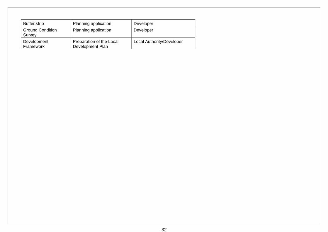
Buffer strip Planning application Developer
Ground Condition Survey
Planning application Developer
Development Framework
Preparation of the Local Development Plan
Local Authority/Developer
33
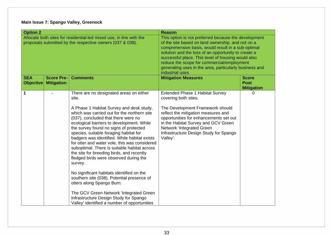
Main Issue 7: Spango Valley, Greenock Option 2 Reason Allocate both sites for residential-led mixed use, in line with the proposals submitted by the respective owners (037 & 038).
This option is not preferred because the development of the site based on land ownership, and not on a comprehensive basis, would result in a sub-optimal solution and the loss of an opportunity to create a successful place. This level of housing would also reduce the scope for commercial/employment generating uses in the area, particularly business and industrial uses.
SEA Objective
Score Pre-Mitigation
Comments Mitigation Measures Score Post Mitigation
1 - There are no designated areas on either site. A Phase 1 Habitat Survey and desk study, which was carried out for the northern site (037), concluded that there were no ecological barriers to development. While the survey found no signs of protected species, suitable foraging habitat for badgers was identified. While habitat exists for otter and water vole, this was considered suboptimal. There is suitable habitat across the site for breeding birds, and recently fledged birds were observed during the survey. No significant habitats identified on the southern site (038). Potential presence of otters along Spango Burn. The GCV Green Network ‘Integrated Green Infrastructure Design Study for Spango Valley’ identified a number of opportunities
Extended Phase 1 Habitat Survey covering both sites. The Development Framework should reflect the mitigation measures and opportunities for enhancements set out in the Habitat Survey and GCV Green Network ‘Integrated Green Infrastructure Design Study for Spango Valley’.
0
34
for environmental enhancements.
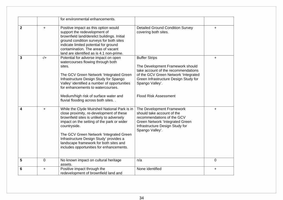
2 + Positive impact as this option would support the redevelopment of brownfield land/derelict buildings. Initial ground condition surveys for both sites indicate limited potential for ground contamination. The areas of vacant land are identified as is 4.1 non-prime.
Detailed Ground Condition Survey covering both sites.
+
3 -/+ Potential for adverse impact on open watercourses flowing through both sites. The GCV Green Network ‘Integrated Green Infrastructure Design Study for Spango Valley’ identified a number of opportunities for enhancements to watercourses. Medium/high risk of surface water and fluvial flooding across both sites. .
Buffer Strips The Development Framework should take account of the recommendations of the GCV Green Network ‘Integrated Green Infrastructure Design Study for Spango Valley’. Flood Risk Assessment
+
4 + While the Clyde Muirsheil National Park is in close proximity, re-development of these brownfield sites is unlikely to adversely impact on the setting of the park or wider countryside. The GCV Green Network ‘Integrated Green Infrastructure Design Study’ provides a landscape framework for both sites and includes opportunities for enhancements.
The Development Framework should take account of the recommendations of the GCV Green Network ‘Integrated Green Infrastructure Design Study for Spango Valley’.
+
5 0 No known impact on cultural heritage assets.
n/a 0
6 + Positive impact through the redevelopment of brownfield land and
None identified +
35
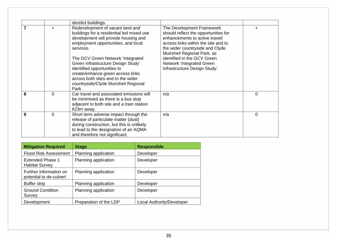
derelict buildings. 7 + Redevelopment of vacant land and
buildings for a residential led mixed use development will provide housing and employment opportunities, and local services. The GCV Green Network ‘Integrated Green Infrastructure Design Study’ identified opportunities to create/enhance green access links across both sites and to the wider countryside/Clyde Muirsheil Regional Park.
The Development Framework should reflect the opportunities for enhancements to active travel/ access links within the site and to the wider countryside and Clyde Muirsheil Regional Park, as identified in the GCV Green Network ‘Integrated Green Infrastructure Design Study’.
+
8 0 Car travel and associated emissions will be minimised as there is a bus stop adjacent to both site and a train station 623m away.
n/a 0
9 0 Short term adverse impact through the release of particulate matter (dust) during construction, but this is unlikely to lead to the designation of an AQMA and therefore not significant.
n/a 0
Mitigation Required Stage Responsible
Flood Risk Assessment Planning application Developer
Extended Phase 1 Habitat Survey
Planning application Developer
Further information on potential to de-culvert
Planning application Developer
Buffer strip Planning application Developer
Ground Condition Survey
Planning application Developer
Development Preparation of the LDP Local Authority/Developer

36
Framework
37
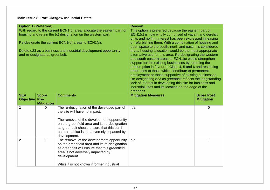
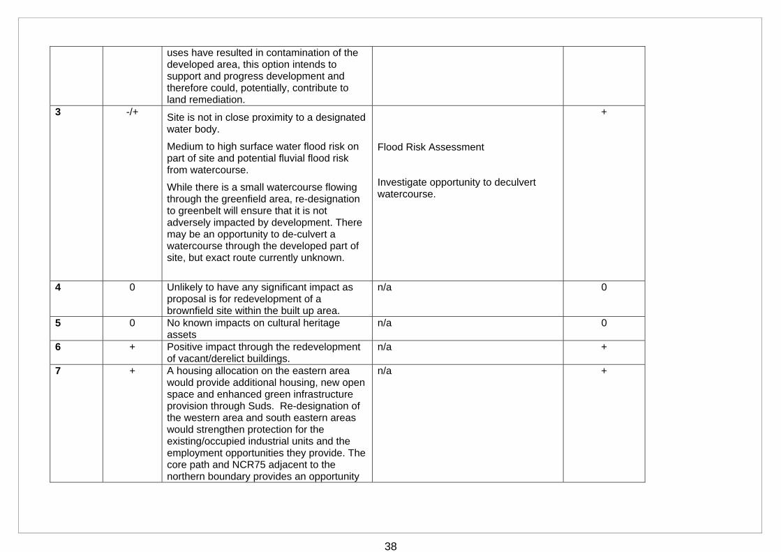
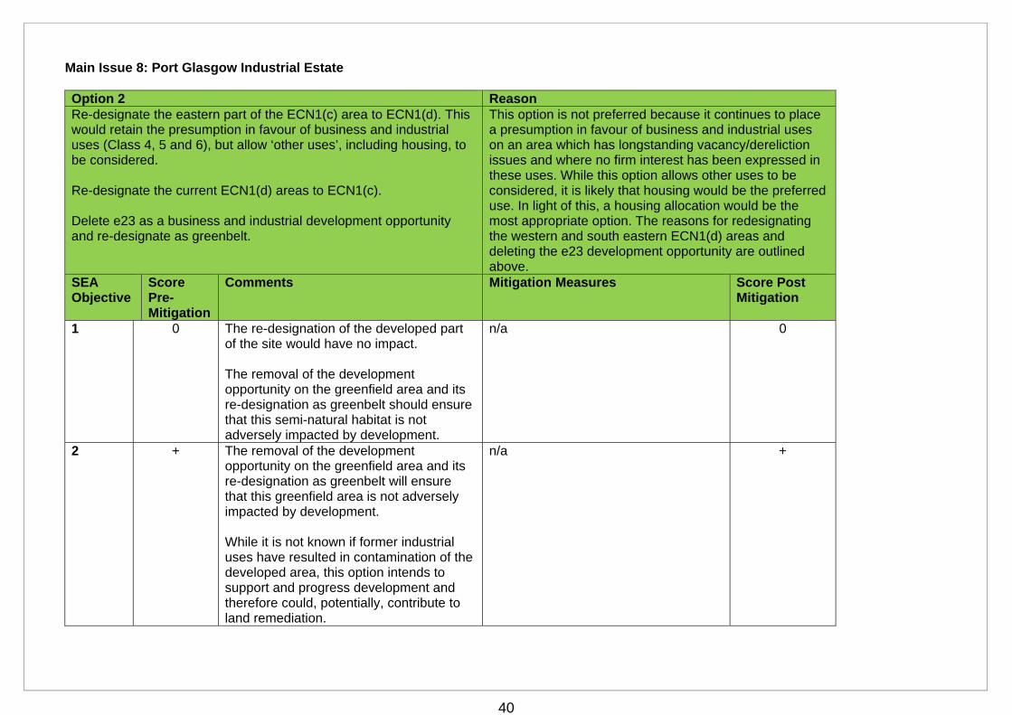
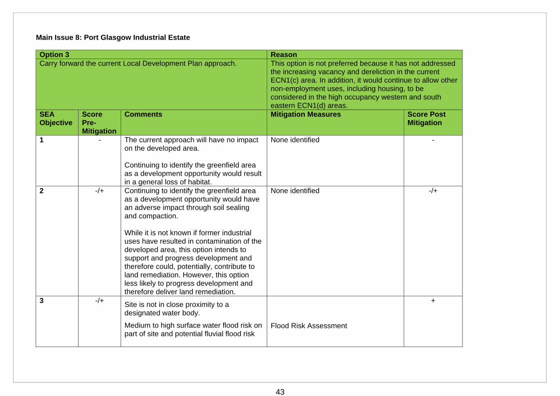
Main Issue 8: Port Glasgow Industrial Estate Option 1 (Preferred) Reason With regard to the current ECN1(c) area, allocate the eastern part for housing and retain the (c) designation on the western part. Re-designate the current ECN1(d) areas to ECN1(c). Delete e23 as a business and industrial development opportunity and re-designate as greenbelt.
This option is preferred because the eastern part of ECN1(c) is now wholly comprised of vacant and derelict units and no firm interest has been expressed in leasing or refurbishing them. With a combination of housing and open space to the south, north and east, it is considered that a housing allocation would be the most appropriate alternative use for this area. Re-designating the western and south eastern areas to ECN1(c) would strengthen support for the existing businesses by retaining the presumption in favour of Class 4, 5 and 6 and restricting other uses to those which contribute to permanent employment or those supportive of existing businesses. Re-designating e23 as greenbelt reflects the longstanding lack of interest in developing this site for business and industrial uses and its location on the edge of the greenbelt.
SEA Objective
Score Pre-Mitigation
Comments Mitigation Measures Score Post Mitigation
1 0 The re-designation of the developed part of the site will have no impact. The removal of the development opportunity on the greenfield area and its re-designation as greenbelt should ensure that this semi-natural habitat is not adversely impacted by development.
n/a 0
2 + The removal of the development opportunity on the greenfield area and its re-designation as greenbelt will ensure that this greenfield area is not adversely impacted by development. While it is not known if former industrial
n/a +
38
uses have resulted in contamination of the developed area, this option intends to support and progress development and therefore could, potentially, contribute to land remediation.
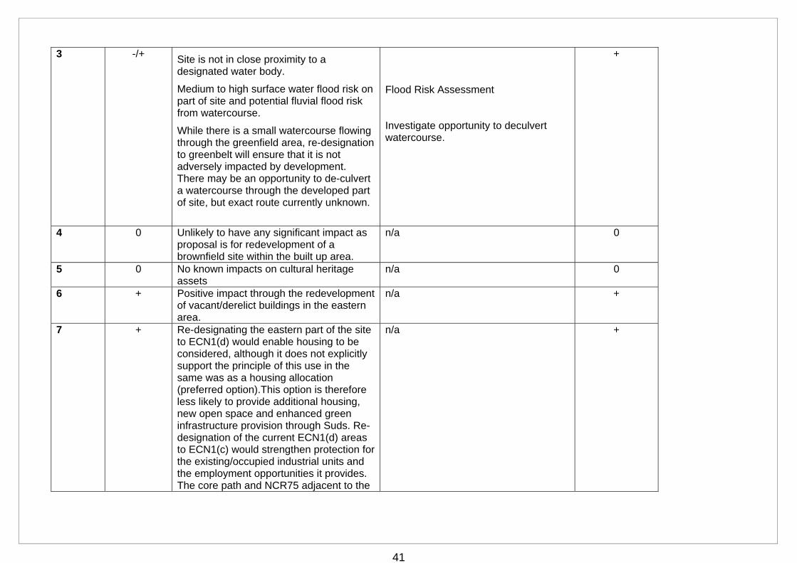
3 -/+ Site is not in close proximity to a designated water body.
Medium to high surface water flood risk on part of site and potential fluvial flood risk from watercourse.
While there is a small watercourse flowing through the greenfield area, re-designation to greenbelt will ensure that it is not adversely impacted by development. There may be an opportunity to de-culvert a watercourse through the developed part of site, but exact route currently unknown.
Flood Risk Assessment Investigate opportunity to deculvert watercourse.
+
4 0 Unlikely to have any significant impact as proposal is for redevelopment of a brownfield site within the built up area.
n/a 0
5 0 No known impacts on cultural heritage assets
n/a 0
6 + Positive impact through the redevelopment of vacant/derelict buildings.
n/a +
7 + A housing allocation on the eastern area would provide additional housing, new open space and enhanced green infrastructure provision through Suds. Re-designation of the western area and south eastern areas would strengthen protection for the existing/occupied industrial units and the employment opportunities they provide. The core path and NCR75 adjacent to the northern boundary provides an opportunity
n/a +
39
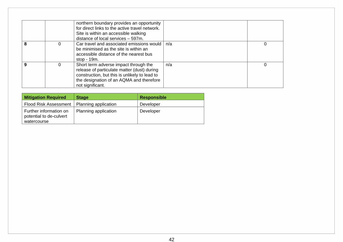
for direct links to the active travel network. Site is within an accessible walking distance of local services – 597m.
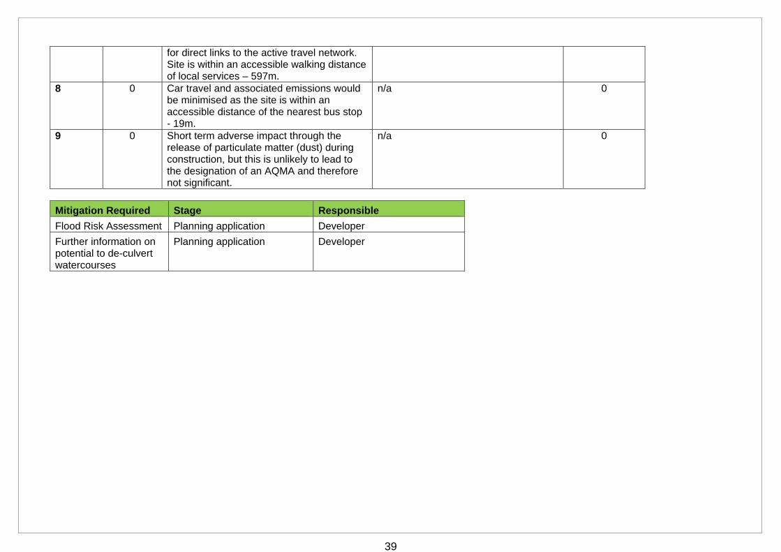
8 0 Car travel and associated emissions would be minimised as the site is within an accessible distance of the nearest bus stop - 19m.
n/a 0
9 0 Short term adverse impact through the release of particulate matter (dust) during construction, but this is unlikely to lead to the designation of an AQMA and therefore not significant.
n/a 0
Mitigation Required Stage Responsible
Flood Risk Assessment Planning application Developer
Further information on potential to de-culvert watercourses
Planning application Developer
40
Main Issue 8: Port Glasgow Industrial Estate Option 2 Reason Re-designate the eastern part of the ECN1(c) area to ECN1(d). This would retain the presumption in favour of business and industrial uses (Class 4, 5 and 6), but allow ‘other uses’, including housing, to be considered. Re-designate the current ECN1(d) areas to ECN1(c). Delete e23 as a business and industrial development opportunity and re-designate as greenbelt.
This option is not preferred because it continues to place a presumption in favour of business and industrial uses on an area which has longstanding vacancy/dereliction issues and where no firm interest has been expressed in these uses. While this option allows other uses to be considered, it is likely that housing would be the preferred use. In light of this, a housing allocation would be the most appropriate option. The reasons for redesignating the western and south eastern ECN1(d) areas and deleting the e23 development opportunity are outlined above.
SEA Objective
Score Pre-Mitigation
Comments Mitigation Measures Score Post Mitigation
1 0 The re-designation of the developed part of the site would have no impact. The removal of the development opportunity on the greenfield area and its re-designation as greenbelt should ensure that this semi-natural habitat is not adversely impacted by development.
n/a 0
2 + The removal of the development opportunity on the greenfield area and its re-designation as greenbelt will ensure that this greenfield area is not adversely impacted by development. While it is not known if former industrial uses have resulted in contamination of the developed area, this option intends to support and progress development and therefore could, potentially, contribute to land remediation.
n/a +
41
3 -/+ Site is not in close proximity to a designated water body.
Medium to high surface water flood risk on part of site and potential fluvial flood risk from watercourse.
While there is a small watercourse flowing through the greenfield area, re-designation to greenbelt will ensure that it is not adversely impacted by development. There may be an opportunity to de-culvert a watercourse through the developed part of site, but exact route currently unknown.
Flood Risk Assessment Investigate opportunity to deculvert watercourse.
+
4 0 Unlikely to have any significant impact as proposal is for redevelopment of a brownfield site within the built up area.
n/a 0
5 0 No known impacts on cultural heritage assets
n/a 0
6 + Positive impact through the redevelopment of vacant/derelict buildings in the eastern area.
n/a +
7 + Re-designating the eastern part of the site to ECN1(d) would enable housing to be considered, although it does not explicitly support the principle of this use in the same was as a housing allocation (preferred option).This option is therefore less likely to provide additional housing, new open space and enhanced green infrastructure provision through Suds. Re-designation of the current ECN1(d) areas to ECN1(c) would strengthen protection for the existing/occupied industrial units and the employment opportunities it provides. The core path and NCR75 adjacent to the
n/a +
42
northern boundary provides an opportunity for direct links to the active travel network. Site is within an accessible walking distance of local services – 597m.
8 0 Car travel and associated emissions would be minimised as the site is within an accessible distance of the nearest bus stop - 19m.
n/a 0
9 0 Short term adverse impact through the release of particulate matter (dust) during construction, but this is unlikely to lead to the designation of an AQMA and therefore not significant.
n/a 0
Mitigation Required Stage Responsible
Flood Risk Assessment Planning application Developer
Further information on potential to de-culvert watercourse
Planning application Developer
43
Main Issue 8: Port Glasgow Industrial Estate Option 3 Reason Carry forward the current Local Development Plan approach. This option is not preferred because it has not addressed
the increasing vacancy and dereliction in the current ECN1(c) area. In addition, it would continue to allow other non-employment uses, including housing, to be considered in the high occupancy western and south eastern ECN1(d) areas.
SEA Objective
Score Pre-Mitigation
Comments Mitigation Measures Score Post Mitigation
1 - The current approach will have no impact on the developed area. Continuing to identify the greenfield area as a development opportunity would result in a general loss of habitat.
None identified -
2 -/+ Continuing to identify the greenfield area as a development opportunity would have an adverse impact through soil sealing and compaction. While it is not known if former industrial uses have resulted in contamination of the developed area, this option intends to support and progress development and therefore could, potentially, contribute to land remediation. However, this option less likely to progress development and therefore deliver land remediation.
None identified -/+
3 -/+ Site is not in close proximity to a designated water body.
Medium to high surface water flood risk on part of site and potential fluvial flood risk
Flood Risk Assessment
+
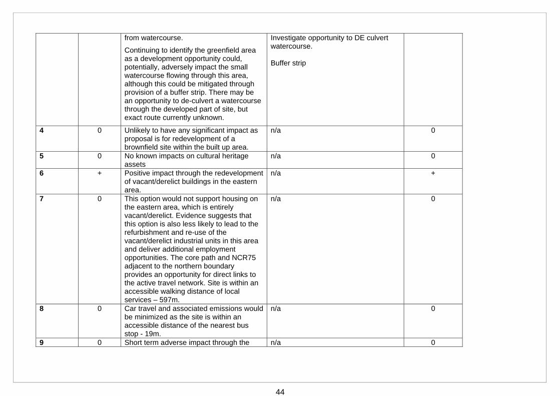
44
from watercourse.
Continuing to identify the greenfield area as a development opportunity could, potentially, adversely impact the small watercourse flowing through this area, although this could be mitigated through provision of a buffer strip. There may be an opportunity to de-culvert a watercourse through the developed part of site, but exact route currently unknown.
Investigate opportunity to DE culvert watercourse. Buffer strip
4 0 Unlikely to have any significant impact as proposal is for redevelopment of a brownfield site within the built up area.
n/a 0
5 0 No known impacts on cultural heritage assets
n/a 0
6 + Positive impact through the redevelopment of vacant/derelict buildings in the eastern area.
n/a +
7 0 This option would not support housing on the eastern area, which is entirely vacant/derelict. Evidence suggests that this option is also less likely to lead to the refurbishment and re-use of the vacant/derelict industrial units in this area and deliver additional employment opportunities. The core path and NCR75 adjacent to the northern boundary provides an opportunity for direct links to the active travel network. Site is within an accessible walking distance of local services – 597m.
n/a 0
8 0 Car travel and associated emissions would be minimized as the site is within an accessible distance of the nearest bus stop - 19m.
n/a 0
9 0 Short term adverse impact through the n/a 0
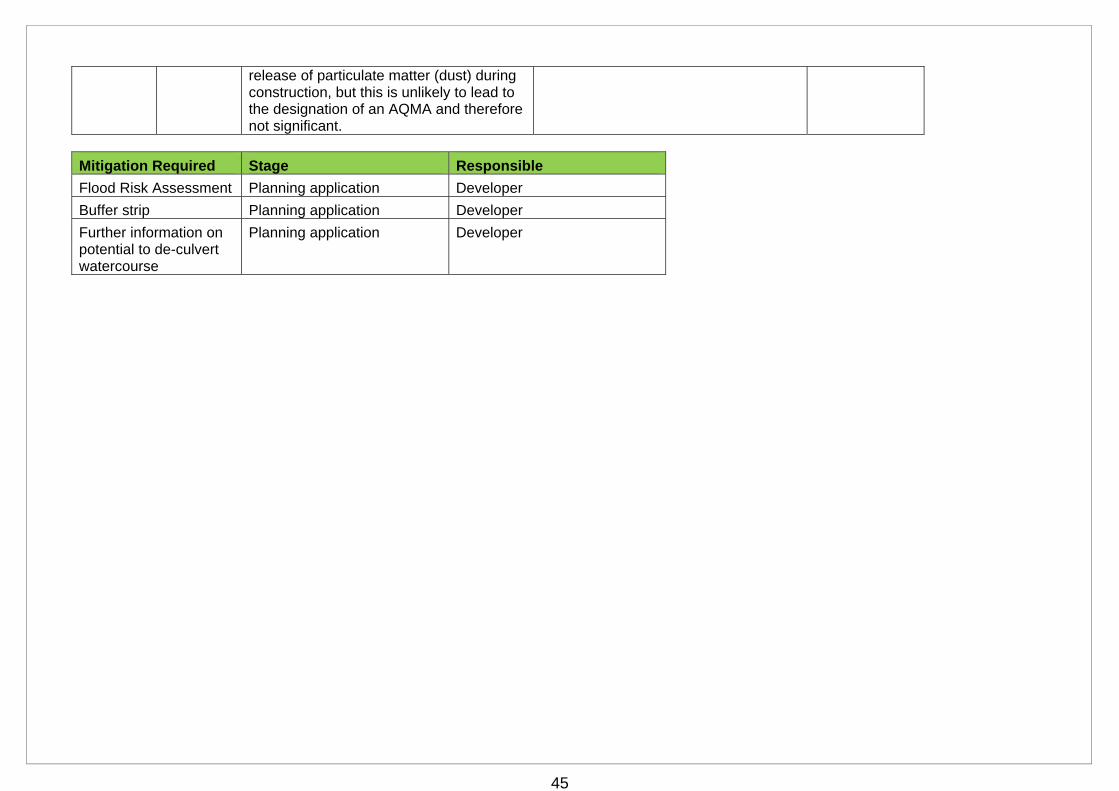
45
release of particulate matter (dust) during construction, but this is unlikely to lead to the designation of an AQMA and therefore not significant.
Mitigation Required Stage Responsible
Flood Risk Assessment Planning application Developer
Buffer strip Planning application Developer
Further information on potential to de-culvert watercourse
Planning application Developer
46
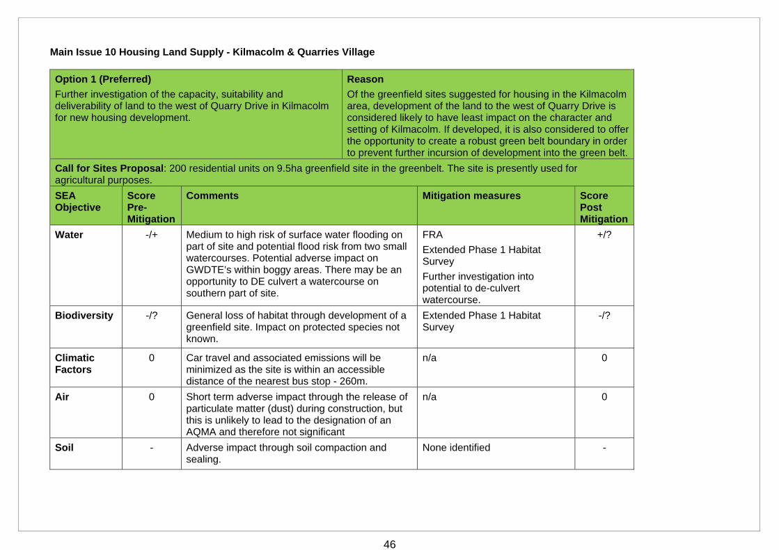
Main Issue 10 Housing Land Supply - Kilmacolm & Quarries Village
Option 1 (Preferred)
Further investigation of the capacity, suitability and deliverability of land to the west of Quarry Drive in Kilmacolm for new housing development.
Reason
Of the greenfield sites suggested for housing in the Kilmacolm area, development of the land to the west of Quarry Drive is considered likely to have least impact on the character and setting of Kilmacolm. If developed, it is also considered to offer the opportunity to create a robust green belt boundary in order to prevent further incursion of development into the green belt.
Call for Sites Proposal: 200 residential units on 9.5ha greenfield site in the greenbelt. The site is presently used for agricultural purposes.
SEA Objective
Score Pre-Mitigation
Comments Mitigation measures Score Post Mitigation
Water -/+ Medium to high risk of surface water flooding on part of site and potential flood risk from two small watercourses. Potential adverse impact on GWDTE’s within boggy areas. There may be an opportunity to DE culvert a watercourse on southern part of site.
FRA
Extended Phase 1 Habitat Survey
Further investigation into potential to de-culvert watercourse.
+/?
Biodiversity -/? General loss of habitat through development of a greenfield site. Impact on protected species not known.
Extended Phase 1 Habitat Survey
-/?
Climatic Factors
0 Car travel and associated emissions will be minimized as the site is within an accessible distance of the nearest bus stop - 260m.
n/a 0
Air 0 Short term adverse impact through the release of particulate matter (dust) during construction, but this is unlikely to lead to the designation of an AQMA and therefore not significant
n/a 0
Soil - Adverse impact through soil compaction and sealing.
None identified -
47
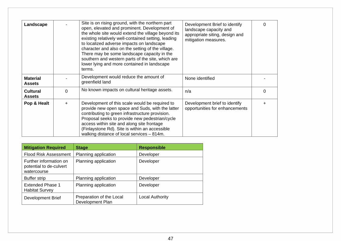
Landscape - Site is on rising ground, with the northern part open, elevated and prominent. Development of the whole site would extend the village beyond its existing relatively well-contained setting, leading to localized adverse impacts on landscape character and also on the setting of the village. There may be some landscape capacity in the southern and western parts of the site, which are lower lying and more contained in landscape terms.
Development Brief to identify landscape capacity and appropriate siting, design and mitigation measures.
0
Material Assets
- Development would reduce the amount of greenfield land
None identified -
Cultural Assets
0 No known impacts on cultural heritage assets. n/a 0
Pop & Healt + Development of this scale would be required to provide new open space and Suds, with the latter contributing to green infrastructure provision. Proposal seeks to provide new pedestrian/cycle access within site and along site frontage (Finlaystone Rd). Site is within an accessible walking distance of local services – 814m.
Development brief to identify opportunities for enhancements
+
Mitigation Required Stage Responsible
Flood Risk Assessment Planning application Developer
Further information on potential to de-culvert watercourse
Planning application Developer
Buffer strip Planning application Developer
Extended Phase 1 Habitat Survey
Planning application Developer
Development Brief Preparation of the Local Development Plan
Local Authority
48
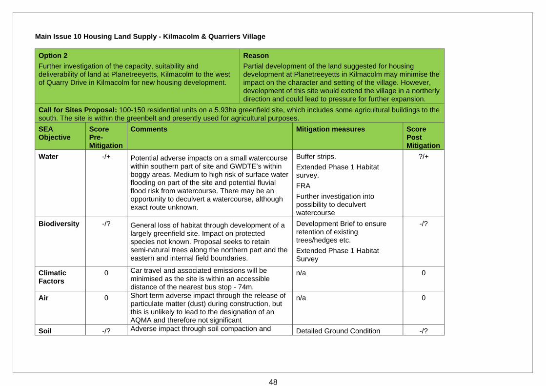
Main Issue 10 Housing Land Supply - Kilmacolm & Quarriers Village
Option 2
Further investigation of the capacity, suitability and deliverability of land at Planetreeyetts, Kilmacolm to the west of Quarry Drive in Kilmacolm for new housing development.
Reason
Partial development of the land suggested for housing development at Planetreeyetts in Kilmacolm may minimise the impact on the character and setting of the village. However, development of this site would extend the village in a northerly direction and could lead to pressure for further expansion.
Call for Sites Proposal: 100-150 residential units on a 5.93ha greenfield site, which includes some agricultural buildings to the south. The site is within the greenbelt and presently used for agricultural purposes.
SEA Objective
Score Pre-Mitigation
Comments Mitigation measures Score Post Mitigation
Water -/+ Potential adverse impacts on a small watercourse within southern part of site and GWDTE’s within boggy areas. Medium to high risk of surface water flooding on part of the site and potential fluvial flood risk from watercourse. There may be an opportunity to deculvert a watercourse, although exact route unknown.
Buffer strips.
Extended Phase 1 Habitat survey.
FRA
Further investigation into possibility to deculvert watercourse
?/+
Biodiversity -/? General loss of habitat through development of a largely greenfield site. Impact on protected species not known. Proposal seeks to retain semi-natural trees along the northern part and the eastern and internal field boundaries.
Development Brief to ensure retention of existing trees/hedges etc.
Extended Phase 1 Habitat Survey
-/?
Climatic Factors
0 Car travel and associated emissions will be minimised as the site is within an accessible distance of the nearest bus stop - 74m.
n/a 0
Air 0 Short term adverse impact through the release of particulate matter (dust) during construction, but this is unlikely to lead to the designation of an AQMA and therefore not significant
n/a 0
Soil -/? Adverse impact through soil compaction and Detailed Ground Condition -/?
49
sealing. Some ground contamination may exist in the vicinity of the farm buildings to the south. While this is unlikely to be significant, further survey work is required to confirm this.
Survey
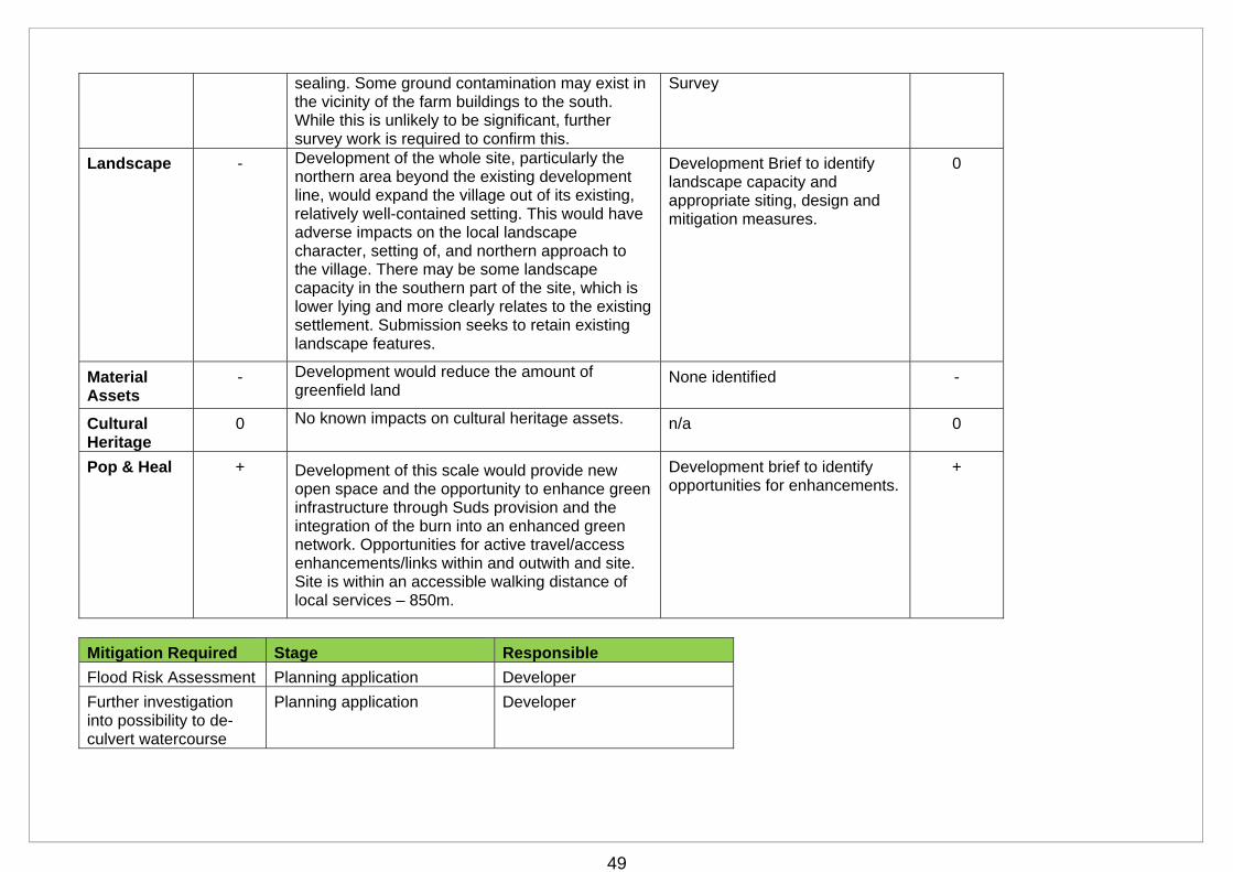
Landscape - Development of the whole site, particularly the northern area beyond the existing development line, would expand the village out of its existing, relatively well-contained setting. This would have adverse impacts on the local landscape character, setting of, and northern approach to the village. There may be some landscape capacity in the southern part of the site, which is lower lying and more clearly relates to the existing settlement. Submission seeks to retain existing landscape features.
Development Brief to identify landscape capacity and appropriate siting, design and mitigation measures.
0
Material Assets
- Development would reduce the amount of greenfield land
None identified -
Cultural Heritage
0 No known impacts on cultural heritage assets. n/a 0
Pop & Heal + Development of this scale would provide new open space and the opportunity to enhance green infrastructure through Suds provision and the integration of the burn into an enhanced green network. Opportunities for active travel/access enhancements/links within and outwith and site. Site is within an accessible walking distance of local services – 850m.
Development brief to identify opportunities for enhancements.
+
Mitigation Required Stage Responsible
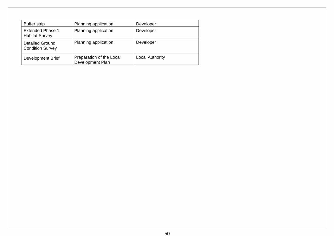
Flood Risk Assessment Planning application Developer
Further investigation into possibility to de-culvert watercourse
Planning application Developer
50
Buffer strip Planning application Developer
Extended Phase 1 Habitat Survey
Planning application Developer
Detailed Ground Condition Survey
Planning application Developer
Development Brief Preparation of the Local Development Plan
Local Authority
51
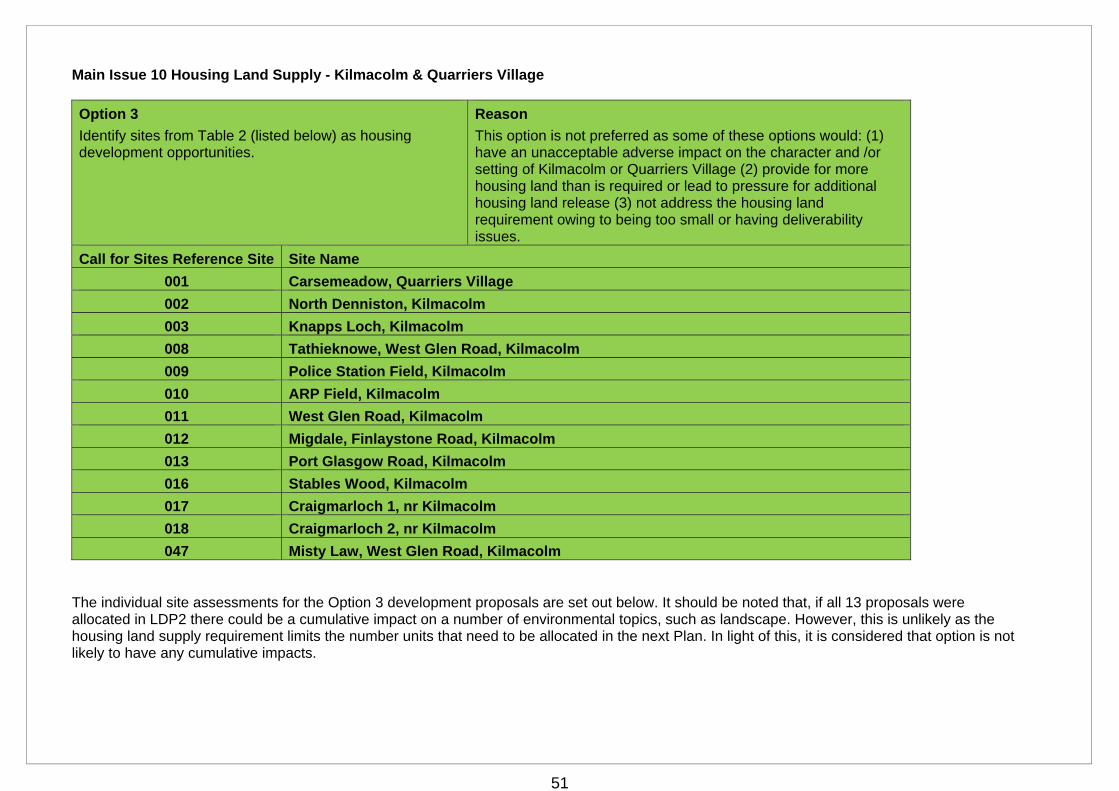
Main Issue 10 Housing Land Supply - Kilmacolm & Quarriers Village
The individual site assessments for the Option 3 development proposals are set out below. It should be noted that, if all 13 proposals were allocated in LDP2 there could be a cumulative impact on a number of environmental topics, such as landscape. However, this is unlikely as the housing land supply requirement limits the number units that need to be allocated in the next Plan. In light of this, it is considered that option is not likely to have any cumulative impacts.
Option 3
Identify sites from Table 2 (listed below) as housing development opportunities.
Reason
This option is not preferred as some of these options would: (1) have an unacceptable adverse impact on the character and /or setting of Kilmacolm or Quarriers Village (2) provide for more housing land than is required or lead to pressure for additional housing land release (3) not address the housing land requirement owing to being too small or having deliverability issues.
Call for Sites Reference Site Site Name
001 Carsemeadow, Quarriers Village
002 North Denniston, Kilmacolm
003 Knapps Loch, Kilmacolm
008 Tathieknowe, West Glen Road, Kilmacolm
009 Police Station Field, Kilmacolm
010 ARP Field, Kilmacolm
011 West Glen Road, Kilmacolm
012 Migdale, Finlaystone Road, Kilmacolm
013 Port Glasgow Road, Kilmacolm
016 Stables Wood, Kilmacolm
017 Craigmarloch 1, nr Kilmacolm
018 Craigmarloch 2, nr Kilmacolm
047 Misty Law, West Glen Road, Kilmacolm
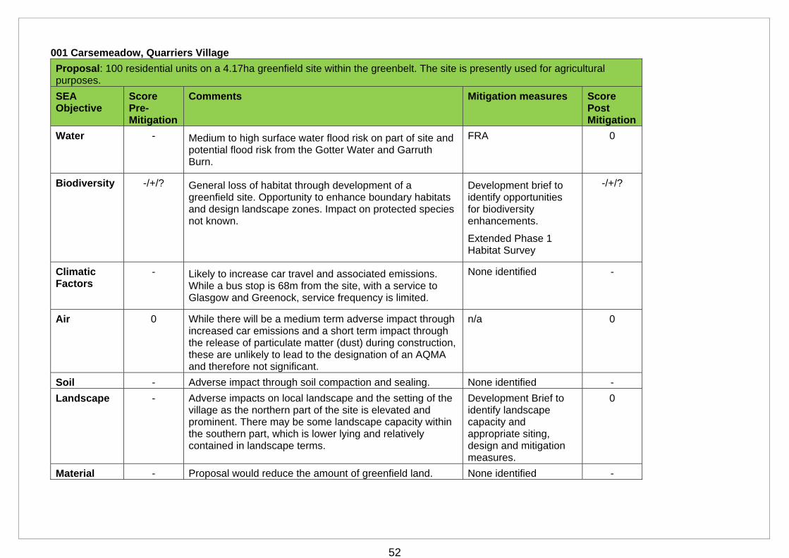
52
001 Carsemeadow, Quarriers Village
Proposal: 100 residential units on a 4.17ha greenfield site within the greenbelt. The site is presently used for agricultural purposes.
SEA Objective
Score Pre-Mitigation
Comments Mitigation measures Score Post Mitigation
Water - Medium to high surface water flood risk on part of site and potential flood risk from the Gotter Water and Garruth Burn.
FRA 0
Biodiversity -/+/? General loss of habitat through development of a greenfield site. Opportunity to enhance boundary habitats and design landscape zones. Impact on protected species not known.
Development brief to identify opportunities for biodiversity enhancements.
Extended Phase 1 Habitat Survey
-/+/?
Climatic Factors
- Likely to increase car travel and associated emissions. While a bus stop is 68m from the site, with a service to Glasgow and Greenock, service frequency is limited.
None identified -
Air 0 While there will be a medium term adverse impact through increased car emissions and a short term impact through the release of particulate matter (dust) during construction, these are unlikely to lead to the designation of an AQMA and therefore not significant.
n/a 0
Soil - Adverse impact through soil compaction and sealing. None identified -
Landscape - Adverse impacts on local landscape and the setting of the village as the northern part of the site is elevated and prominent. There may be some landscape capacity within the southern part, which is lower lying and relatively contained in landscape terms.
Development Brief to identify landscape capacity and appropriate siting, design and mitigation measures.
0
Material - Proposal would reduce the amount of greenfield land. None identified -
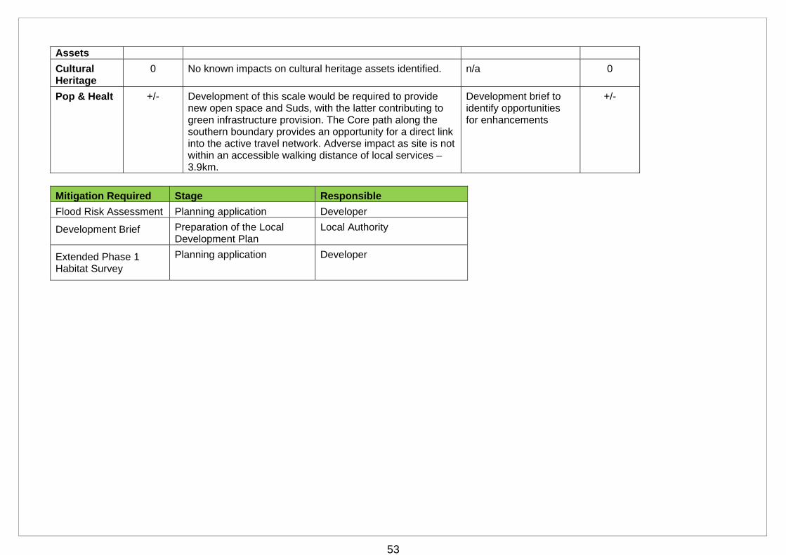
53
Assets
Cultural Heritage
0 No known impacts on cultural heritage assets identified. n/a 0
Pop & Healt +/- Development of this scale would be required to provide new open space and Suds, with the latter contributing to green infrastructure provision. The Core path along the southern boundary provides an opportunity for a direct link into the active travel network. Adverse impact as site is not within an accessible walking distance of local services – 3.9km.
Development brief to identify opportunities for enhancements
+/-
Mitigation Required Stage Responsible
Flood Risk Assessment Planning application Developer
Development Brief Preparation of the Local Development Plan
Local Authority
Extended Phase 1 Habitat Survey
Planning application Developer
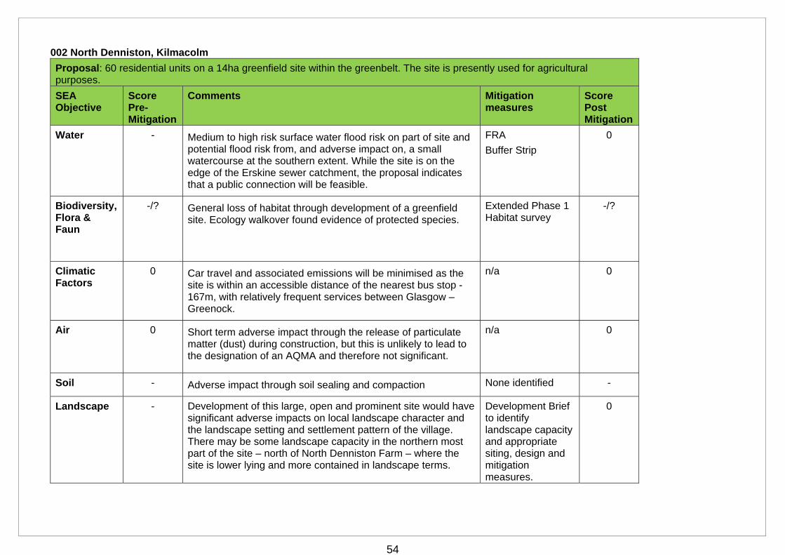
54
002 North Denniston, Kilmacolm
Proposal: 60 residential units on a 14ha greenfield site within the greenbelt. The site is presently used for agricultural purposes.
SEA Objective
Score Pre-Mitigation
Comments Mitigation measures
Score Post Mitigation
Water - Medium to high risk surface water flood risk on part of site and potential flood risk from, and adverse impact on, a small watercourse at the southern extent. While the site is on the edge of the Erskine sewer catchment, the proposal indicates that a public connection will be feasible.
FRA
Buffer Strip
0
Biodiversity, Flora & Faun
-/? General loss of habitat through development of a greenfield site. Ecology walkover found evidence of protected species.
Extended Phase 1 Habitat survey
-/?
Climatic Factors
0 Car travel and associated emissions will be minimised as the site is within an accessible distance of the nearest bus stop - 167m, with relatively frequent services between Glasgow – Greenock.
n/a 0
Air 0 Short term adverse impact through the release of particulate matter (dust) during construction, but this is unlikely to lead to the designation of an AQMA and therefore not significant.
n/a 0
Soil - Adverse impact through soil sealing and compaction None identified -
Landscape - Development of this large, open and prominent site would have significant adverse impacts on local landscape character and the landscape setting and settlement pattern of the village. There may be some landscape capacity in the northern most part of the site – north of North Denniston Farm – where the site is lower lying and more contained in landscape terms.
Development Brief to identify landscape capacity and appropriate siting, design and mitigation measures.
0

55
Material Assets
- Proposal would reduce the amount of greenfield land. n/a -
Cultural Assets
0 No known impacts on cultural heritage assets n/a 0
Pop & Healt + Development of this scale would be required to provide new open space and Suds, with the latter contributing to green infrastructure provision There are opportunities to create an east - west green link through the site and a direct link to the active travel network. Site is not within an accessible walking distance of local services – 1.27km.
Development brief to identify opportunities for enhancements
+
Mitigation Required Stage Responsible
Flood Risk Assessment Planning application Developer
Buffer strip Planning application Developer
Development Brief Preparation of Local Development Plan
Local Authority
Extended Phase 1 Habitat survey
Planning application Developer
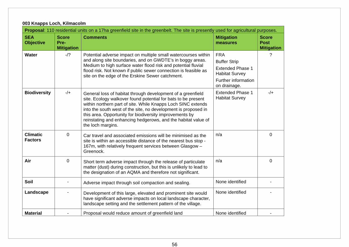
56
003 Knapps Loch, Kilmacolm
Proposal: 110 residential units on a 17ha greenfield site in the greenbelt. The site is presently used for agricultural purposes.
SEA Objective
Score Pre-Mitigation
Comments Mitigation measures
Score Post Mitigation
Water -/? Potential adverse impact on multiple small watercourses within and along site boundaries, and on GWDTE’s in boggy areas. Medium to high surface water flood risk and potential fluvial flood risk. Not known if public sewer connection is feasible as site on the edge of the Erskine Sewer catchment.
FRA
Buffer Strip
Extended Phase 1 Habitat Survey
Further information on drainage.
?
Biodiversity -/+ General loss of habitat through development of a greenfield site. Ecology walkover found potential for bats to be present within northern part of site. While Knapps Loch SINC extends into the south west of the site, no development is proposed in this area. Opportunity for biodiversity improvements by reinstating and enhancing hedgerows, and the habitat value of the loch margins.
Extended Phase 1 Habitat Survey
-/+
Climatic Factors
0 Car travel and associated emissions will be minimised as the site is within an accessible distance of the nearest bus stop - 167m, with relatively frequent services between Glasgow – Greenock.
n/a 0
Air 0 Short term adverse impact through the release of particulate matter (dust) during construction, but this is unlikely to lead to the designation of an AQMA and therefore not significant.
n/a 0
Soil - Adverse impact through soil compaction and sealing. None identified -
Landscape - Development of this large, elevated and prominent site would have significant adverse impacts on local landscape character, landscape setting and the settlement pattern of the village.
None identified -
Material - Proposal would reduce amount of greenfield land None identified -
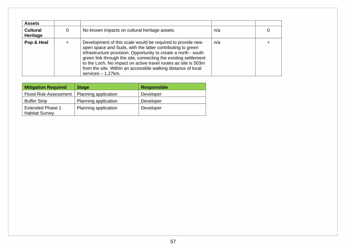
57
Assets
Cultural Heritage
0 No known impacts on cultural heritage assets. n/a 0
Pop & Heal + Development of this scale would be required to provide new open space and Suds, with the latter contributing to green infrastructure provision. Opportunity to create a north - south green link through the site, connecting the existing settlement to the Loch. No impact on active travel routes as site is 503m from the site. Within an accessible walking distance of local services – 1.27km.
n/a +
Mitigation Required Stage Responsible
Flood Risk Assessment Planning application Developer
Buffer Strip Planning application Developer
Extended Phase 1 Habitat Survey
Planning application Developer
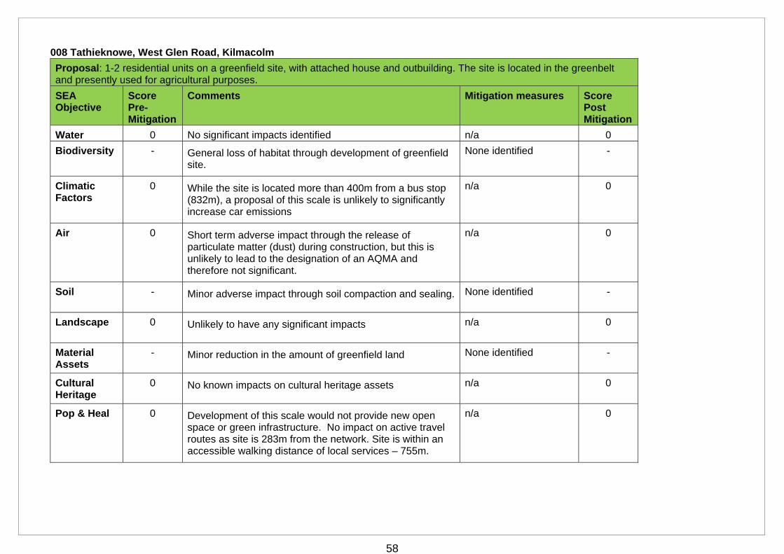
58
008 Tathieknowe, West Glen Road, Kilmacolm
Proposal: 1-2 residential units on a greenfield site, with attached house and outbuilding. The site is located in the greenbelt and presently used for agricultural purposes.
SEA Objective
Score Pre-Mitigation
Comments Mitigation measures Score Post Mitigation
Water 0 No significant impacts identified n/a 0
Biodiversity - General loss of habitat through development of greenfield site.
None identified -
Climatic Factors
0 While the site is located more than 400m from a bus stop (832m), a proposal of this scale is unlikely to significantly increase car emissions
n/a 0
Air 0 Short term adverse impact through the release of particulate matter (dust) during construction, but this is unlikely to lead to the designation of an AQMA and therefore not significant.
n/a 0
Soil - Minor adverse impact through soil compaction and sealing. None identified -
Landscape 0 Unlikely to have any significant impacts n/a 0
Material Assets
- Minor reduction in the amount of greenfield land None identified -
Cultural Heritage
0 No known impacts on cultural heritage assets n/a 0
Pop & Heal 0 Development of this scale would not provide new open space or green infrastructure. No impact on active travel routes as site is 283m from the network. Site is within an accessible walking distance of local services – 755m.
n/a 0

59
009 Police Station Field, Kilmacolm
Proposal: 50-100 residential units on a 19.5ha greenfield site in the greenbelt. The site is presently used for agricultural purposes.
SEA Objective
Score Pre-Mitigation
Comments Mitigation measures Score Post Mitigation
Water -/? Development could, potentially, adversely impact the River Gryfe, which is adjacent to the southern boundary. Medium to high risk of surface and fluvial flooding on part of site. Not known if public sewer connection is feasible as site is on edge of the Erskine sewer catchment.
Buffer strip
FRA
Further info on drainage
?
Biodiversity -/+/? Depending on location of development, proposal could have a significant adverse impact on the Duchal Estate SINC, which extends into the western part of the site. While the proposal seeks to retain main body of woodland, some woodland loss is likely. Evidence of bats and otters on site. Submission indicates opportunities for biodiversity enhancements, although these are not stated.
Development Brief to identify development capacity and proposed biodiversity enhancements.
Extended Phase 1 Habitat covering whole site
+/?
Climatic Factors
0 Car travel and associated emissions would be minimised as the site is within an accessible distance of the nearest bus stop - 366m, with relatively frequent services between Glasgow – Greenock.
n/a 0
Air 0 Short term adverse impact through the release of particulate matter (dust) during construction, but this is unlikely to lead to the designation of an AQMA and therefore not significant
n/a 0
Soil - Adverse impact through soil compaction and sealing. None identified -
Landscape - Development of the whole site would have significant adverse impacts on local landscape character and the landscape setting and settlement pattern of the village. There may be some landscape capacity within the northern part of the site.
Development brief to identify landscape capacity and appropriate siting, design and mitigation measures
0
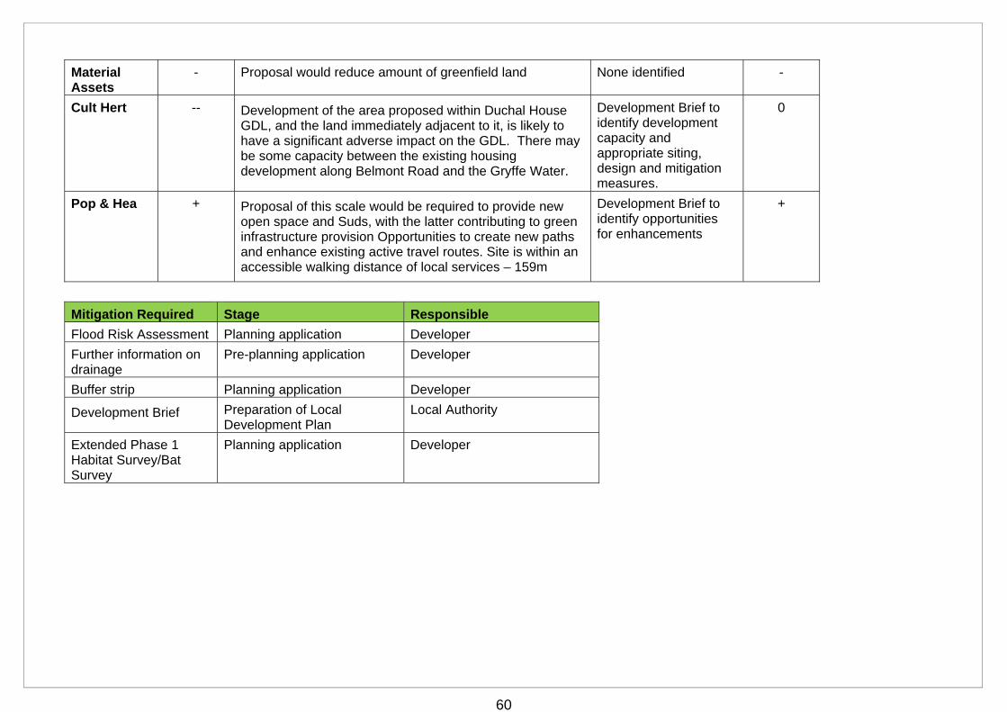
60
Material Assets
- Proposal would reduce amount of greenfield land None identified -
Cult Hert -- Development of the area proposed within Duchal House GDL, and the land immediately adjacent to it, is likely to have a significant adverse impact on the GDL. There may be some capacity between the existing housing development along Belmont Road and the Gryffe Water.
Development Brief to identify development capacity and appropriate siting, design and mitigation measures.
0
Pop & Hea + Proposal of this scale would be required to provide new open space and Suds, with the latter contributing to green infrastructure provision Opportunities to create new paths and enhance existing active travel routes. Site is within an accessible walking distance of local services – 159m
Development Brief to identify opportunities for enhancements
+
Mitigation Required Stage Responsible
Flood Risk Assessment Planning application Developer
Further information on drainage
Pre-planning application Developer
Buffer strip Planning application Developer
Development Brief Preparation of Local Development Plan
Local Authority
Extended Phase 1 Habitat Survey/Bat Survey
Planning application Developer
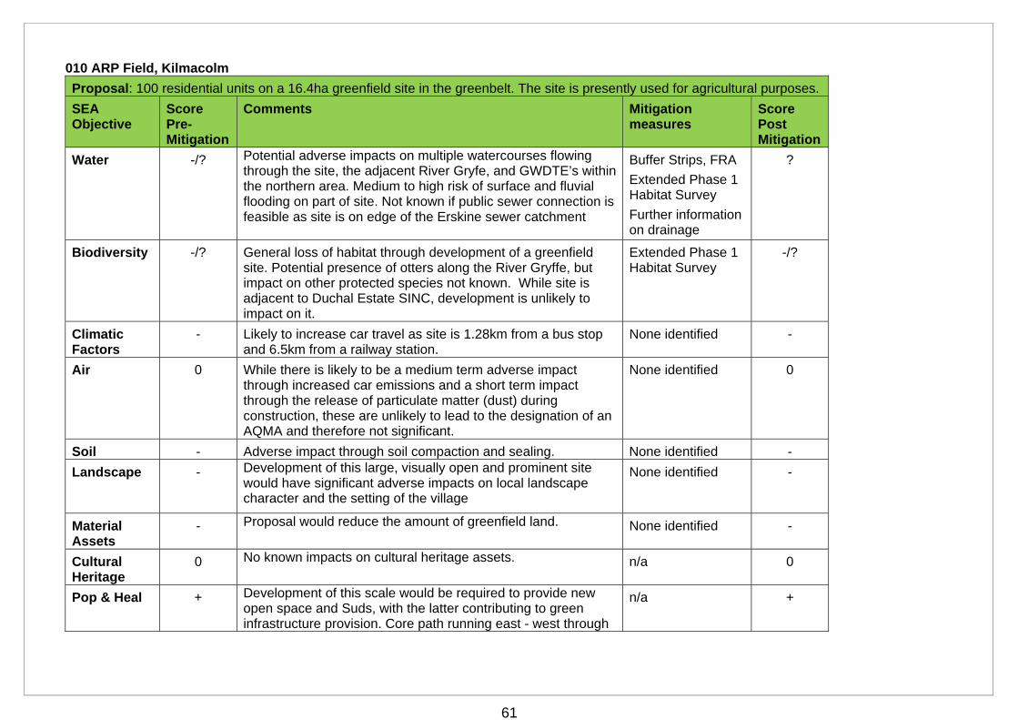
61
010 ARP Field, Kilmacolm
Proposal: 100 residential units on a 16.4ha greenfield site in the greenbelt. The site is presently used for agricultural purposes.
SEA Objective
Score Pre-Mitigation
Comments Mitigation measures
Score Post Mitigation
Water -/? Potential adverse impacts on multiple watercourses flowing through the site, the adjacent River Gryfe, and GWDTE’s within the northern area. Medium to high risk of surface and fluvial flooding on part of site. Not known if public sewer connection is feasible as site is on edge of the Erskine sewer catchment
Buffer Strips, FRA
Extended Phase 1 Habitat Survey
Further information on drainage
?
Biodiversity -/? General loss of habitat through development of a greenfield site. Potential presence of otters along the River Gryffe, but impact on other protected species not known. While site is adjacent to Duchal Estate SINC, development is unlikely to impact on it.
Extended Phase 1 Habitat Survey
-/?
Climatic Factors
- Likely to increase car travel as site is 1.28km from a bus stop and 6.5km from a railway station.
None identified -
Air 0 While there is likely to be a medium term adverse impact through increased car emissions and a short term impact through the release of particulate matter (dust) during construction, these are unlikely to lead to the designation of an AQMA and therefore not significant.
None identified 0
Soil - Adverse impact through soil compaction and sealing. None identified -
Landscape - Development of this large, visually open and prominent site would have significant adverse impacts on local landscape character and the setting of the village
None identified -
Material Assets
- Proposal would reduce the amount of greenfield land. None identified -
Cultural Heritage
0 No known impacts on cultural heritage assets. n/a 0
Pop & Heal + Development of this scale would be required to provide new open space and Suds, with the latter contributing to green infrastructure provision. Core path running east - west through
n/a +
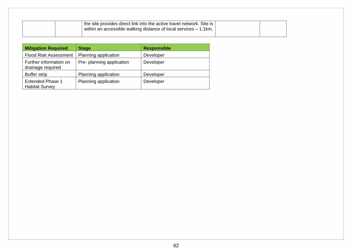
62
the site provides direct link into the active travel network. Site is within an accessible walking distance of local services – 1.1km.
Mitigation Required Stage Responsible
Flood Risk Assessment Planning application Developer
Further information on drainage required
Pre- planning application Developer
Buffer strip Planning application Developer
Extended Phase 1 Habitat Survey
Planning application Developer
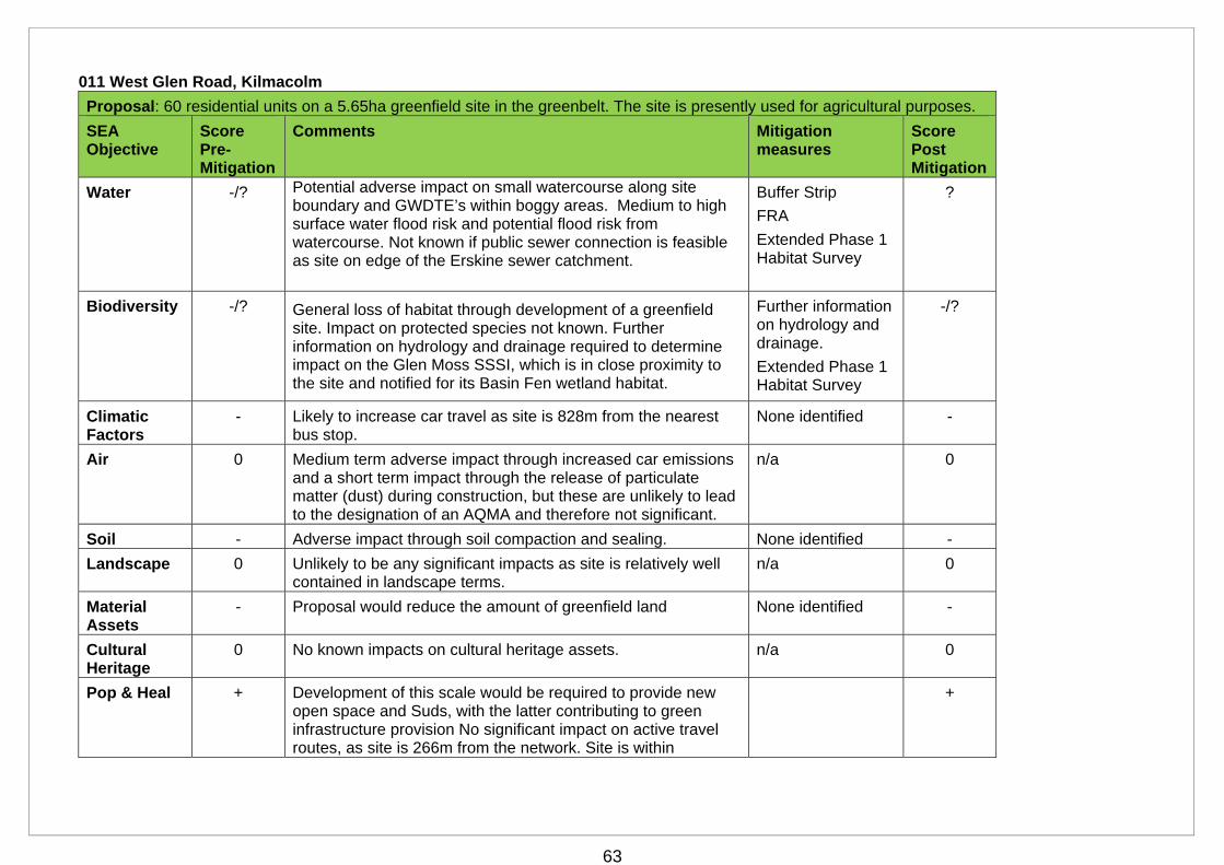
63
011 West Glen Road, Kilmacolm
Proposal: 60 residential units on a 5.65ha greenfield site in the greenbelt. The site is presently used for agricultural purposes.
SEA Objective
Score Pre-Mitigation
Comments Mitigation measures
Score Post Mitigation
Water -/? Potential adverse impact on small watercourse along site boundary and GWDTE’s within boggy areas. Medium to high surface water flood risk and potential flood risk from watercourse. Not known if public sewer connection is feasible as site on edge of the Erskine sewer catchment.
Buffer Strip
FRA
Extended Phase 1 Habitat Survey
?
Biodiversity -/? General loss of habitat through development of a greenfield site. Impact on protected species not known. Further information on hydrology and drainage required to determine impact on the Glen Moss SSSI, which is in close proximity to the site and notified for its Basin Fen wetland habitat.
Further information on hydrology and drainage.
Extended Phase 1 Habitat Survey
-/?
Climatic Factors
- Likely to increase car travel as site is 828m from the nearest bus stop.
None identified -
Air 0 Medium term adverse impact through increased car emissions and a short term impact through the release of particulate matter (dust) during construction, but these are unlikely to lead to the designation of an AQMA and therefore not significant.
n/a 0
Soil - Adverse impact through soil compaction and sealing. None identified -
Landscape 0 Unlikely to be any significant impacts as site is relatively well contained in landscape terms.
n/a 0
Material Assets
- Proposal would reduce the amount of greenfield land None identified -
Cultural Heritage
0 No known impacts on cultural heritage assets. n/a 0
Pop & Heal + Development of this scale would be required to provide new open space and Suds, with the latter contributing to green infrastructure provision No significant impact on active travel routes, as site is 266m from the network. Site is within
+

64
accessible walking distance of local services – 732m.
Mitigation Required Stage Responsible
Flood Risk Assessment Planning application Developer
Further information on drainage/hydrology required
Prior to the allocation of the site in the Local Development Plan.
Developer
Buffer strip Planning application Developer
Extended Phase 1 Habitat Survey
Planning application Developer
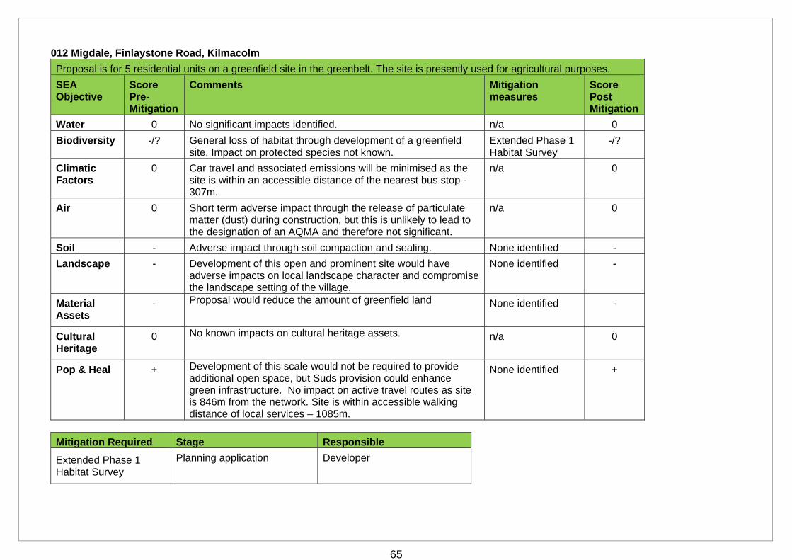
65
012 Migdale, Finlaystone Road, Kilmacolm
Proposal is for 5 residential units on a greenfield site in the greenbelt. The site is presently used for agricultural purposes.
SEA Objective
Score Pre-Mitigation
Comments Mitigation measures
Score Post Mitigation
Water 0 No significant impacts identified. n/a 0
Biodiversity -/? General loss of habitat through development of a greenfield site. Impact on protected species not known.
Extended Phase 1 Habitat Survey
-/?
Climatic Factors
0 Car travel and associated emissions will be minimised as the site is within an accessible distance of the nearest bus stop - 307m.
n/a 0
Air 0 Short term adverse impact through the release of particulate matter (dust) during construction, but this is unlikely to lead to the designation of an AQMA and therefore not significant.
n/a 0
Soil - Adverse impact through soil compaction and sealing. None identified -
Landscape - Development of this open and prominent site would have adverse impacts on local landscape character and compromise the landscape setting of the village.
None identified -
Material Assets
- Proposal would reduce the amount of greenfield land None identified -
Cultural Heritage
0 No known impacts on cultural heritage assets. n/a 0
Pop & Heal + Development of this scale would not be required to provide additional open space, but Suds provision could enhance green infrastructure. No impact on active travel routes as site is 846m from the network. Site is within accessible walking distance of local services – 1085m.
None identified +
Mitigation Required Stage Responsible
Extended Phase 1 Habitat Survey
Planning application Developer
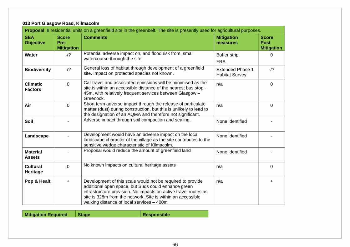
66
013 Port Glasgow Road, Kilmacolm
Proposal: 8 residential units on a greenfield site in the greenbelt. The site is presently used for agricultural purposes.
SEA Objective
Score Pre-Mitigation
Comments Mitigation measures
Score Post Mitigation
Water -/? Potential adverse impact on, and flood risk from, small watercourse through the site.
Buffer strip
FRA
0
Biodiversity -/? General loss of habitat through development of a greenfield site. Impact on protected species not known.
Extended Phase 1 Habitat Survey
-/?
Climatic Factors
0 Car travel and associated emissions will be minimised as the site is within an accessible distance of the nearest bus stop - 45m, with relatively frequent services between Glasgow – Greenock.
n/a 0
Air 0 Short term adverse impact through the release of particulate matter (dust) during construction, but this is unlikely to lead to the designation of an AQMA and therefore not significant.
n/a 0
Soil - Adverse impact through soil compaction and sealing. None identified -
Landscape - Development would have an adverse impact on the local landscape character of the village as the site contributes to the sensitive wedge characteristic of Kilmacolm.
None identified -
Material Assets
- Proposal would reduce the amount of greenfield land None identified -
Cultural Heritage
0 No known impacts on cultural heritage assets n/a 0
Pop & Healt + Development of this scale would not be required to provide additional open space, but Suds could enhance green infrastructure provision. No impacts on active travel routes as site is 328m from the network. Site is within an accessible walking distance of local services – 400m
n/a +
Mitigation Required Stage Responsible
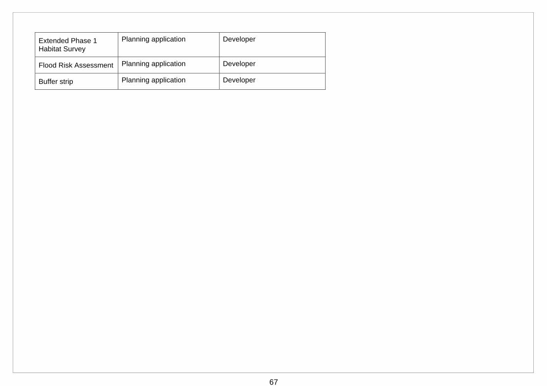
67
Extended Phase 1 Habitat Survey
Planning application Developer
Flood Risk Assessment Planning application Developer
Buffer strip Planning application Developer
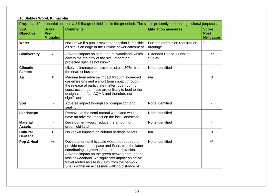
68
016 Stables Wood, Kilmacolm
Proposal: 10 residential units on a 2.04ha greenfield site in the greenbelt. The site is presently used for agricultural purposes.
SEA Objective
Score Pre-Mitigation
Comments Mitigation measures Score Post Mitigation
Water ? Not known if a public sewer connection is feasible as site is on edge of the Erskine sewer catchment
Further information required on drainage
?
Biodiversity -/? Adverse impact on semi-natural woodland, which covers the majority of the site. Impact on protected species not known
Extended Phase 1 Habitat Survey
-/?
Climatic Factors
- Likely to increase car travel as site is 807m from the nearest bus stop.
None identified -
Air 0 Medium term adverse impact through increased car emissions and a short term impact through the release of particulate matter (dust) during construction, but these are unlikely to lead to the designation of an AQMA and therefore not significant
n/a 0
Soil - Adverse impact through soil compaction and sealing.
None identified -
Landscape - Removal of the semi-natural woodland would have an adverse impact on the local landscape
None identified -
Material Assets
- Development would reduce the amount of greenfield land
None identified -
Cultural Heritage
0 No known impacts on cultural heritage assets. n/a 0
Pop & Heal +/- Development of this scale would be required to provide new open space and Suds, with the latter contributing to green infrastructure provision. Adverse impact on the green network through the loss of woodland. No significant impact on active travel routes as site is 703m from the network. Site is within an accessible walking distance of
None identified +/-
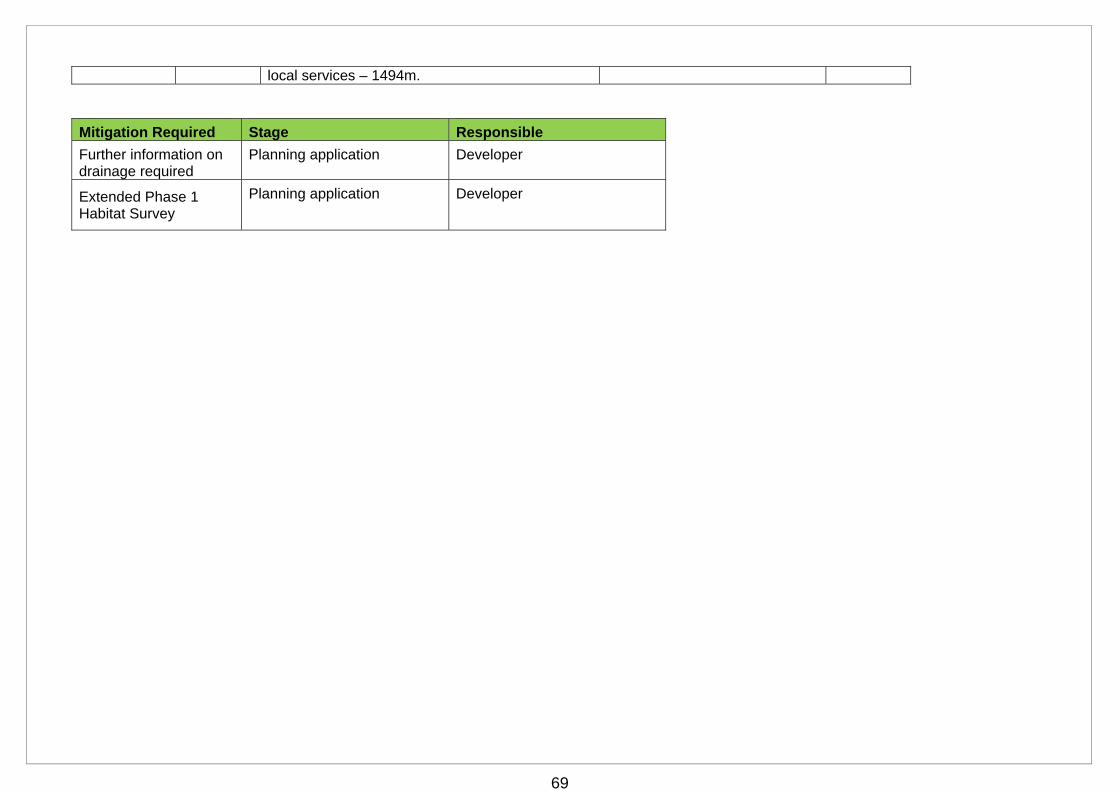
69
local services – 1494m.
Mitigation Required Stage Responsible
Further information on drainage required
Planning application Developer
Extended Phase 1 Habitat Survey
Planning application Developer
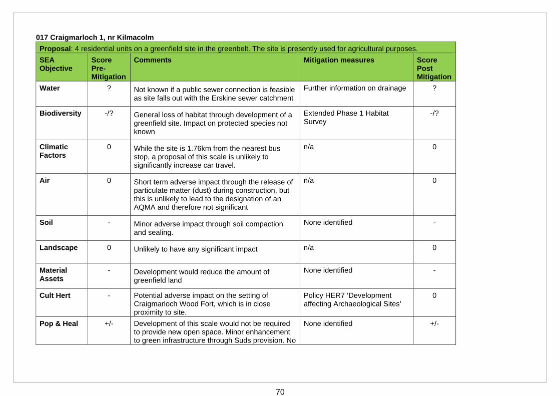
70
017 Craigmarloch 1, nr Kilmacolm
Proposal: 4 residential units on a greenfield site in the greenbelt. The site is presently used for agricultural purposes.
SEA Objective
Score Pre-Mitigation
Comments Mitigation measures Score Post Mitigation
Water ? Not known if a public sewer connection is feasible as site falls out with the Erskine sewer catchment
Further information on drainage ?
Biodiversity -/? General loss of habitat through development of a greenfield site. Impact on protected species not known
Extended Phase 1 Habitat Survey
-/?
Climatic Factors
0 While the site is 1.76km from the nearest bus stop, a proposal of this scale is unlikely to significantly increase car travel.
n/a 0
Air 0 Short term adverse impact through the release of particulate matter (dust) during construction, but this is unlikely to lead to the designation of an AQMA and therefore not significant
n/a 0
Soil - Minor adverse impact through soil compaction and sealing.
None identified -
Landscape 0 Unlikely to have any significant impact n/a 0
Material Assets
- Development would reduce the amount of greenfield land
None identified -
Cult Hert - Potential adverse impact on the setting of Craigmarloch Wood Fort, which is in close proximity to site.
Policy HER7 ‘Development affecting Archaeological Sites’
0
Pop & Heal +/- Development of this scale would not be required to provide new open space. Minor enhancement to green infrastructure through Suds provision. No
None identified +/-
71
impact on active travel routes as site is1.27km from the network. Site is not within an accessible walking distance of local services – 2.4km.
Mitigation Required Stage Responsible
Further information on drainage
Planning application Developer
Extended Phase 1 Habitat Survey
Planning application Developer
Policy HER7 ‘Development affecting Archaeological Sites’
Planning application Local Authority
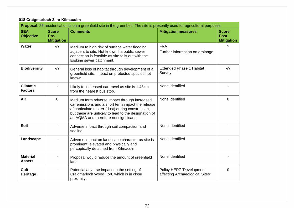
72
018 Craigmarloch 2, nr Kilmacolm
Proposal: 25 residential units on a greenfield site in the greenbelt. The site is presently used for agricultural purposes.
SEA Objective
Score Pre-Mitigation
Comments Mitigation measures Score Post Mitigation
Water -/? Medium to high risk of surface water flooding adjacent to site. Not known if a public sewer connection is feasible as site falls out with the Erskine sewer catchment.
FRA
Further information on drainage
?
Biodiversity -/? General loss of habitat through development of a greenfield site. Impact on protected species not known.
Extended Phase 1 Habitat Survey
-/?
Climatic Factors
- Likely to increased car travel as site is 1.48km from the nearest bus stop.
None identified -
Air 0 Medium term adverse impact through increased car emissions and a short term impact the release of particulate matter (dust) during construction, but these are unlikely to lead to the designation of an AQMA and therefore not significant
None identified 0
Soil - Adverse impact through soil compaction and sealing.
None identified -
Landscape - Adverse impact on landscape character as site is prominent, elevated and physically and perceptually detached from Kilmacolm.
None identified -
Material Assets
- Proposal would reduce the amount of greenfield land
None identified -
Cult Heritage
- Potential adverse impact on the setting of Craigmarloch Wood Fort, which is in close proximity.
Policy HER7 ‘Development affecting Archaeological Sites’
0
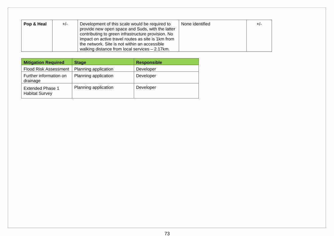
73
Pop & Heal +/- Development of this scale would be required to provide new open space and Suds, with the latter contributing to green infrastructure provision. No impact on active travel routes as site is 1km from the network. Site is not within an accessible walking distance from local services – 2.17km.
None identified +/-
Mitigation Required Stage Responsible
Flood Risk Assessment Planning application Developer
Further information on drainage
Planning application Developer
Extended Phase 1 Habitat Survey
Planning application Developer
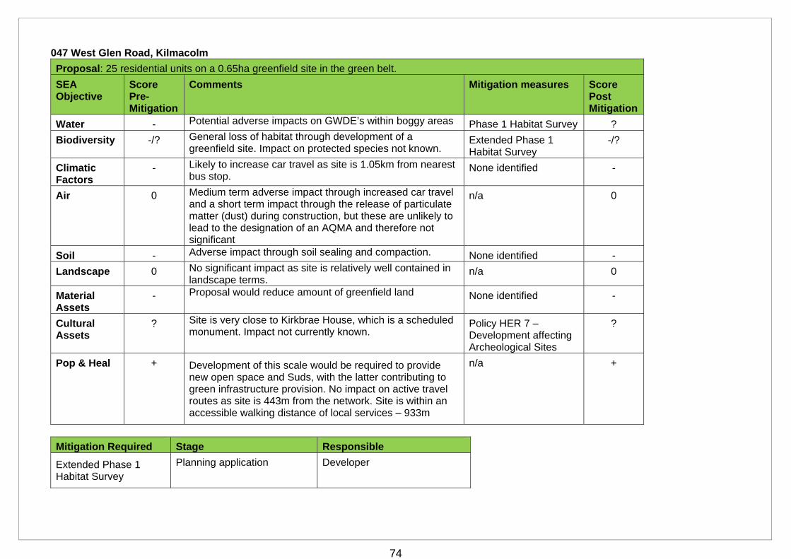
74
047 West Glen Road, Kilmacolm
Proposal: 25 residential units on a 0.65ha greenfield site in the green belt.
SEA Objective
Score Pre-Mitigation
Comments Mitigation measures Score Post Mitigation
Water - Potential adverse impacts on GWDE’s within boggy areas Phase 1 Habitat Survey ?
Biodiversity -/? General loss of habitat through development of a greenfield site. Impact on protected species not known.
Extended Phase 1 Habitat Survey
-/?
Climatic Factors
- Likely to increase car travel as site is 1.05km from nearest bus stop.
None identified -
Air 0 Medium term adverse impact through increased car travel and a short term impact through the release of particulate matter (dust) during construction, but these are unlikely to lead to the designation of an AQMA and therefore not significant
n/a 0
Soil - Adverse impact through soil sealing and compaction. None identified -
Landscape 0 No significant impact as site is relatively well contained in landscape terms.
n/a 0
Material Assets
- Proposal would reduce amount of greenfield land None identified -
Cultural Assets
? Site is very close to Kirkbrae House, which is a scheduled monument. Impact not currently known.
Policy HER 7 – Development affecting Archeological Sites
?
Pop & Heal + Development of this scale would be required to provide new open space and Suds, with the latter contributing to green infrastructure provision. No impact on active travel routes as site is 443m from the network. Site is within an accessible walking distance of local services – 933m
n/a +
Mitigation Required Stage Responsible
Extended Phase 1 Habitat Survey
Planning application Developer
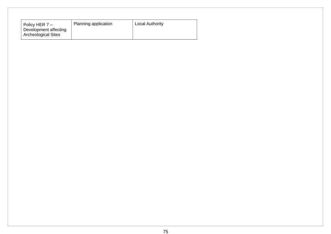
75
Policy HER 7 – Development affecting Archeological Sites
Planning application Local Authority
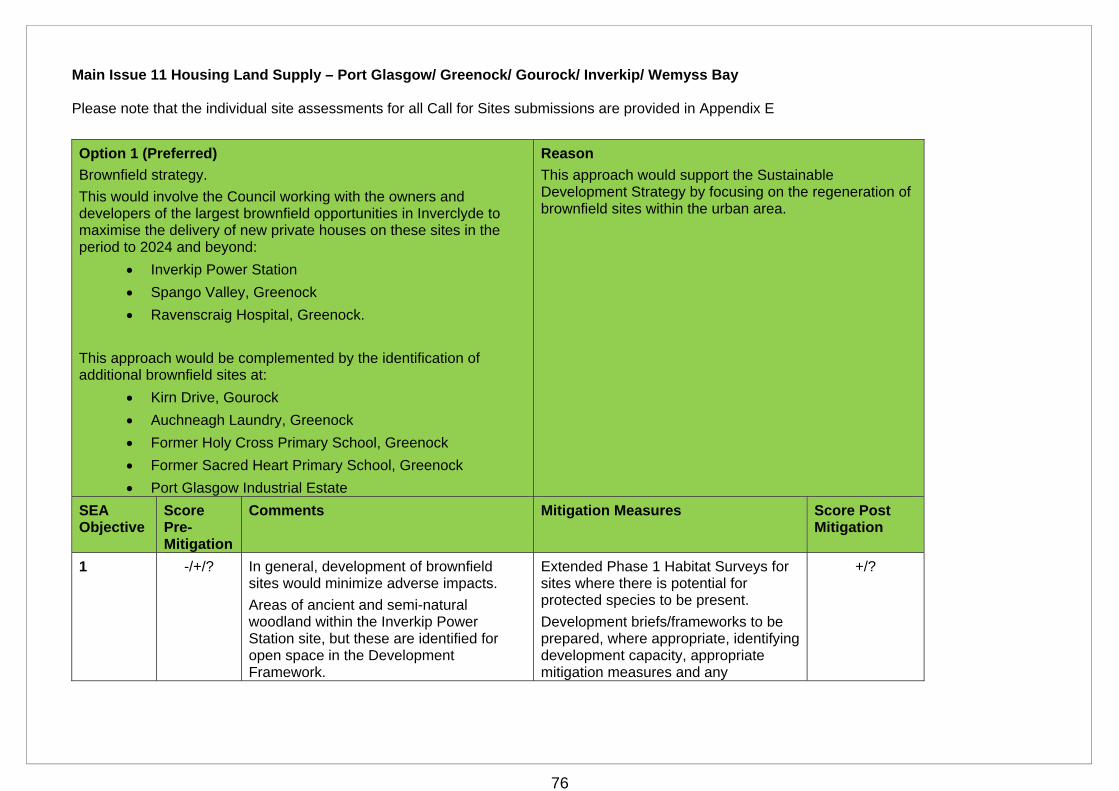
76
Main Issue 11 Housing Land Supply – Port Glasgow/ Greenock/ Gourock/ Inverkip/ Wemyss Bay Please note that the individual site assessments for all Call for Sites submissions are provided in Appendix E
Option 1 (Preferred)
Brownfield strategy.
This would involve the Council working with the owners and developers of the largest brownfield opportunities in Inverclyde to maximise the delivery of new private houses on these sites in the period to 2024 and beyond:
Inverkip Power Station
Spango Valley, Greenock
Ravenscraig Hospital, Greenock.
This approach would be complemented by the identification of additional brownfield sites at:
Kirn Drive, Gourock
Auchneagh Laundry, Greenock
Former Holy Cross Primary School, Greenock
Former Sacred Heart Primary School, Greenock
Port Glasgow Industrial Estate
Reason
This approach would support the Sustainable Development Strategy by focusing on the regeneration of brownfield sites within the urban area.
SEA Objective
Score Pre-Mitigation
Comments Mitigation Measures Score Post Mitigation
1 -/+/? In general, development of brownfield sites would minimize adverse impacts.
Areas of ancient and semi-natural woodland within the Inverkip Power Station site, but these are identified for open space in the Development Framework.
Extended Phase 1 Habitat Surveys for sites where there is potential for protected species to be present.
Development briefs/frameworks to be prepared, where appropriate, identifying development capacity, appropriate mitigation measures and any
+/?
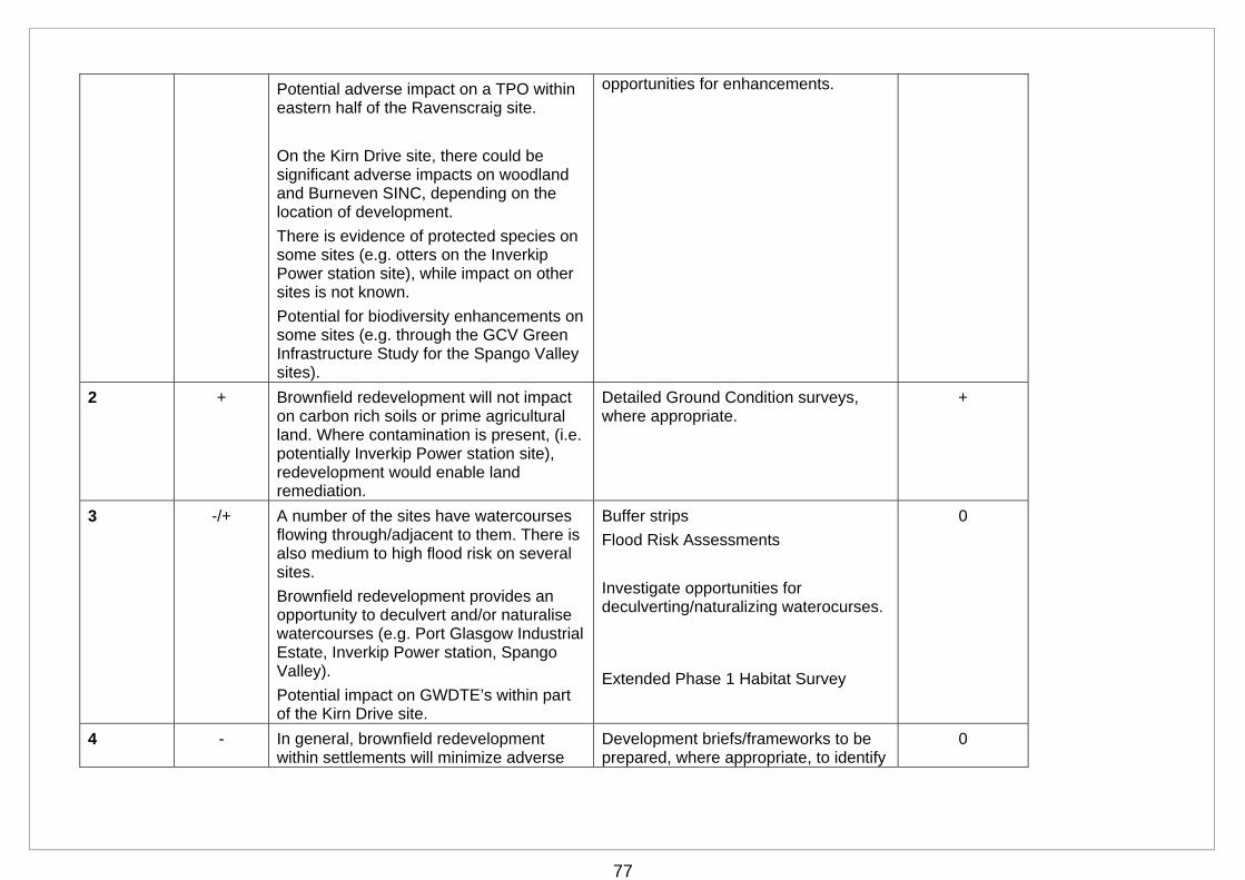
77
Potential adverse impact on a TPO within eastern half of the Ravenscraig site.
On the Kirn Drive site, there could be significant adverse impacts on woodland and Burneven SINC, depending on the location of development.
There is evidence of protected species on some sites (e.g. otters on the Inverkip Power station site), while impact on other sites is not known.
Potential for biodiversity enhancements on some sites (e.g. through the GCV Green Infrastructure Study for the Spango Valley sites).
opportunities for enhancements.
2 + Brownfield redevelopment will not impact on carbon rich soils or prime agricultural land. Where contamination is present, (i.e. potentially Inverkip Power station site), redevelopment would enable land remediation.
Detailed Ground Condition surveys, where appropriate.
+
3 -/+ A number of the sites have watercourses flowing through/adjacent to them. There is also medium to high flood risk on several sites.
Brownfield redevelopment provides an opportunity to deculvert and/or naturalise watercourses (e.g. Port Glasgow Industrial Estate, Inverkip Power station, Spango Valley).
Potential impact on GWDTE’s within part of the Kirn Drive site.
Buffer strips
Flood Risk Assessments
Investigate opportunities for deculverting/naturalizing waterocurses.
Extended Phase 1 Habitat Survey
0
4 - In general, brownfield redevelopment within settlements will minimize adverse
Development briefs/frameworks to be prepared, where appropriate, to identify
0
78
impacts.
Several sites have existing landscape frameworks, which should inform development (i.e. Inverkip Power Station, Spango Valley, Ravenscraig).
On the Ravenscraig site, development could, potentially, have adverse impacts on the strong landscape setting and positive settlement boundary that it provides.
suitable capacity and necessary siting, design, and mitigation measures. These should reflect any existing landscape frameworks.
5 -- It is likely that development of the Ravenscraig site would require the B listed to be demolished.
No known impacts on the other sites.
None identified --
6 + This option would have a cumulative positive impact through the reuse of previously developed land and buildings.
n/a +
7 + There would be a cumulative positive adverse as this option would promote housing and employment opportunities to meet identified needs across Inverclyde. A number of these proposals would also provide opportunities for enhanced access/active travel links. There would also be a cumulative positive impact as all the proposals would be required to provide new open space, and could contribute to green infrastructure through Suds provision.
Development briefs, where appropriate, to identify opportunities for enhancements.
8 + This option promotes development within settlements, where the public transport and active travel networks are most readily accessible, thereby reducing car travel and associated emissions.
Development briefs, where appropriate, to identify opportunities for active travel/access links and enhancements.
+
79
9 0 There are no Air Quality Management Areas (AQMA’s) in Inverclyde. While this option may result in short term adverse impact through the release of particulate matter (dust) during construction, this is unlikely to lead to the designation of an AQMA and therefore not significant.
n/a 0
Mitigation Required Stage Responsible
Flood Risk Assessment Planning application Developer
Extended Phase 1 Habitat Survey
Planning application Developer
Further information on potential to de-culvert
Planning application Developer
Buffer strips Planning application Developer
Ground Condition Survey
Planning application Developer
Development Brief/Framework
Preparation of the Local Development Plan
Local Authority/Developer
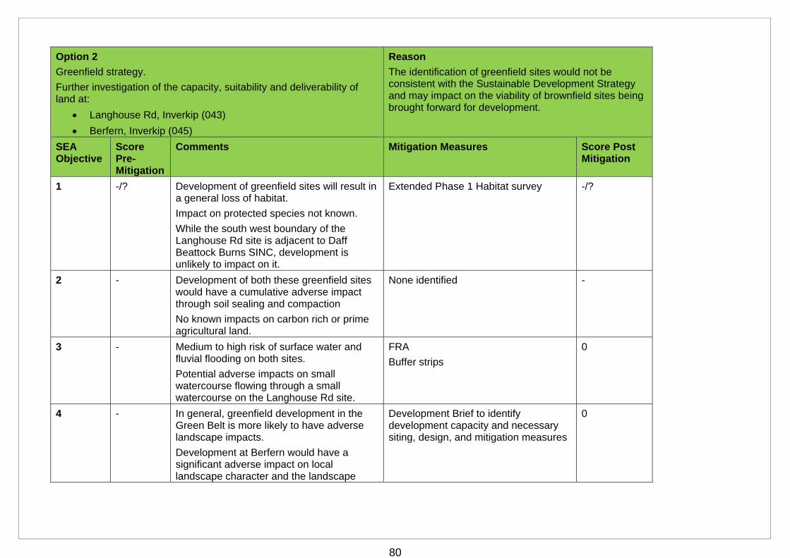
80
Option 2
Greenfield strategy.
Further investigation of the capacity, suitability and deliverability of land at:
Langhouse Rd, Inverkip (043)
Berfern, Inverkip (045)
Reason
The identification of greenfield sites would not be consistent with the Sustainable Development Strategy and may impact on the viability of brownfield sites being brought forward for development.
SEA Objective
Score Pre-Mitigation
Comments Mitigation Measures Score Post Mitigation
1 -/? Development of greenfield sites will result in a general loss of habitat.
Impact on protected species not known.
While the south west boundary of the Langhouse Rd site is adjacent to Daff Beattock Burns SINC, development is unlikely to impact on it.
Extended Phase 1 Habitat survey -/?
2 - Development of both these greenfield sites would have a cumulative adverse impact through soil sealing and compaction
No known impacts on carbon rich or prime agricultural land.
None identified -
3 - Medium to high risk of surface water and fluvial flooding on both sites.
Potential adverse impacts on small watercourse flowing through a small watercourse on the Langhouse Rd site.
FRA
Buffer strips
0
4 - In general, greenfield development in the Green Belt is more likely to have adverse landscape impacts.
Development at Berfern would have a significant adverse impact on local landscape character and the landscape
Development Brief to identify development capacity and necessary siting, design, and mitigation measures
0
81
setting of Inverkip.
There are no landscape designations on the sites.
5 0 No historic sites or designations within or in close proximity to sites.
n/a 0
6 0 Neutral impact as greenfield development would not re-use previously developed land
n/a 0
7 + Development of these sites would provide housing to meet identified needs. Both proposals are also of a scale that would provide new open space, and could contribute to green infrastructure through Suds provision.
Core paths are adjacent/run through the sites, providing an opportunity for directs links into the active travel network. Both sites are also within an accessible walking distance of local services.
Development briefs to identify opportunities for green infrastructure enhancements and active travel/access links.
+
8 - Development of both sites is likely to cumulatively increase car travel and associated emissions as they are both more than 400m from the nearest bus stop and 800m from the nearest train station.
None identified -
9 0 There are no AQMA’s in Inverclyde. Medium term adverse impact through increased car emissions and a short term impact through the release of particulate matter (dust) during construction, but these are unlikely to lead to the designation of an AQMA and therefore not significant.
n/a 0
Mitigation Required Stage Responsible
Flood Risk Assessment Planning application Developer
Extended Phase 1 Planning application Developer
82
Habitat Survey
Buffer strips Planning application Developer
Development Brief Preparation of the Local Development Plan
Local Authority/Developer
83
Main Issue 12: Affordable Housing Policy
Option 1 (Preferred)
Revise the Affordable Housing Policy to seek a 10% affordable housing contribution from all private sector housing sites with a capacity for 20 or more dwellings.
Reason
The draft Local Housing Strategy 2017- 2022 supports the continuation of an affordable housing policy in the new Local Development Plan. The application of the policy to all sites is a more consistent approach. The reduction of contribution to 10% reduces the impact on the viability of private sector development
SEA Objective
Score Pre-Mitigation
Comments Mitigation Measures Score Post Mitigation
1 0 This option will affect the level of affordable housing contribution that will be sought on existing and new private housing sites, but will not lead to any new development taking place. It will therefore have no impact on biodiversity, soil, water, landscape, cultural heritage, material assets, climatic factors or air.
The policy aims to ensure the provision of affordable housing to meet the needs of those who cannot access the private housing market, and would thereby have a cumulative positive impact on population and health.
n/a 0
2 0 n/a 0
3 0 n/a 0
4 0 n/a 0
5 0 n/a 0
6 0 n/a 0
7 + n/a +
8 0 n/a 0
9 0 n/a 0
84
Main Issue 12: Affordable Housing Policy
Option 2
Remove the affordable housing policy i.e. do not seek an affordable housing contribution from private sector sites.
Reason
This option would increase the viability, and therefore deliverability, of private sector housing sites. However, it would not help to increase tenure choice throughout the Council area.
SEA Objective
Score Pre-Mitigation
Comments Mitigation Measures Score Post Mitigation
1 0 This option will affect the level of affordable housing contribution that will be sought on existing and new private housing sites, but will not lead to any new development taking place; therefore it will have no impact on biodiversity, soil, water, landscape, cultural heritage, material assets, population and health, climatic factors or air.
Affordable housing needs under this option would be met solely by the Registered Social Landlords in the area, with no contribution from the private sector.
n/a 0
2 0 n/a 0
3 0 n/a 0
4 0 n/a 0
5 0 n/a 0
6 0 n/a 0
7 0 n/a 0
8 0 n/a 0
9 0 n/a 0

85
Main Issue 12: Affordable Housing Policy
Option 3
Retain the current Local Development Plan approach of seeking a ‘benchmark’ of 25% affordable housing on specified sites, to be provided on site or, subject to negotiation, off-site or via a commuted sum.
Reason
This option is not preferred as it limits the application of the policy to specified sites and in practice has not been successful in obtaining 25% on-site provision of affordable housing.
SEA Objective
Score Pre-Mitigation
Comments Mitigation Measures Score Post Mitigation
1 0 This option will affect the level of affordable housing contribution that will be sought on existing and new private housing sites, but will not lead to any new development taking place. It will therefore have no impact on biodiversity, soil, water, landscape, cultural heritage, material assets, climatic factors or air.
This policy aims to ensure the provision of affordable housing to meet the needs of those who cannot access the private housing market, and therefore have a cumulative positive impact on population and health.
n/a 0
2 0 n/a 0
3 0 n/a 0
4 0 n/a 0
5 0 n/a 0
6 0 n/a 0
7 + n/a +
8 0 n/a 0
9 0 n/a 0
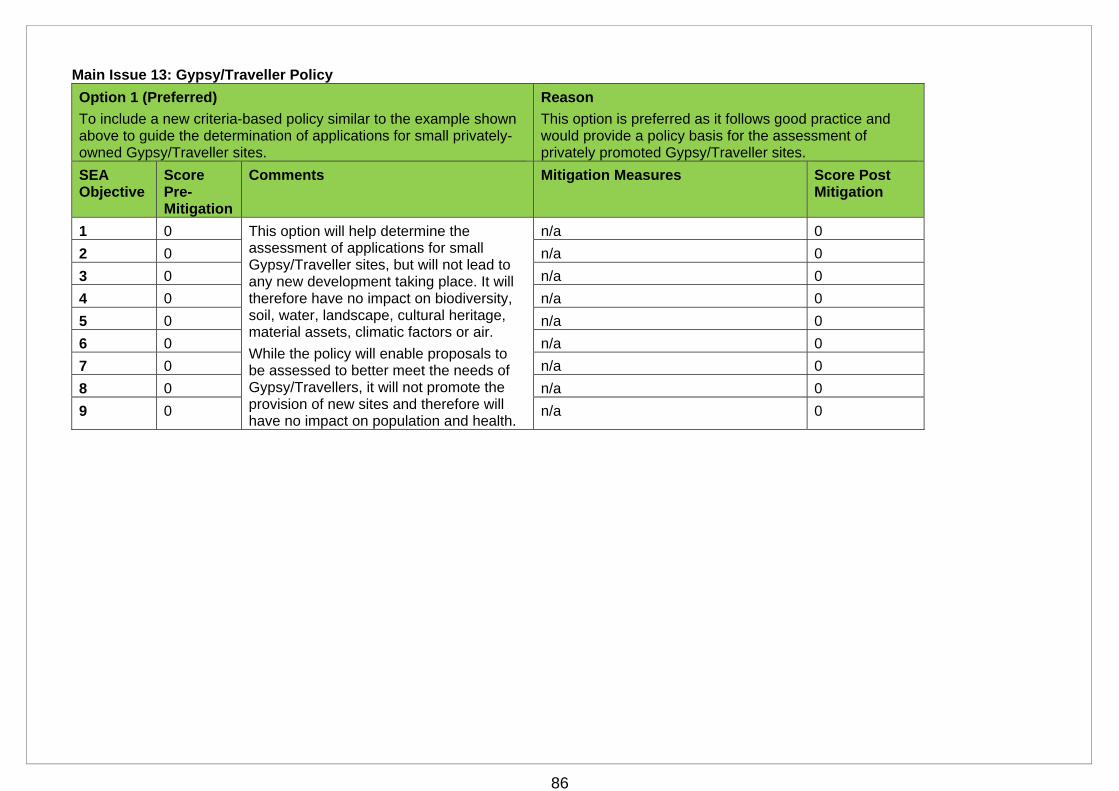
86
Main Issue 13: Gypsy/Traveller Policy
Option 1 (Preferred)
To include a new criteria-based policy similar to the example shown above to guide the determination of applications for small privately-owned Gypsy/Traveller sites.
Reason
This option is preferred as it follows good practice and would provide a policy basis for the assessment of privately promoted Gypsy/Traveller sites.
SEA Objective
Score Pre-Mitigation
Comments Mitigation Measures Score Post Mitigation
1 0 This option will help determine the assessment of applications for small Gypsy/Traveller sites, but will not lead to any new development taking place. It will therefore have no impact on biodiversity, soil, water, landscape, cultural heritage, material assets, climatic factors or air.
While the policy will enable proposals to be assessed to better meet the needs of Gypsy/Travellers, it will not promote the provision of new sites and therefore will have no impact on population and health.
n/a 0
2 0 n/a 0
3 0 n/a 0
4 0 n/a 0
5 0 n/a 0
6 0 n/a 0
7 0 n/a 0
8 0 n/a 0
9 0 n/a 0

87
Main Issue 13: Gypsy/Traveller Policy
Option 2
Do not include a policy for the assessment of Gypsy/Traveller sites.
Reason
This option is not preferred as it would not provide a policy context for the assessment of proposals for Gypsy/Traveller sites.
SEA Objective
Score Pre-Mitigation
Comments Mitigation Measures Score Post Mitigation
1 0 If a specific policy for the assessment of proposals for Gypsy/Traveller sites is not introduced, such proposals will be assessed against the other relevant policies in the plan.
This will not lead to any new development taking place, and will therefore have no impact on biodiversity, soil, water, landscape, cultural heritage, material assets, population and health, climatic factors or air.
n/a 0
2 0 n/a 0
3 0 n/a 0
4 0 n/a 0
5 0 n/a 0
6 0 n/a 0
7 0 n/a 0
8 0 n/a 0
9 0 n/a 0
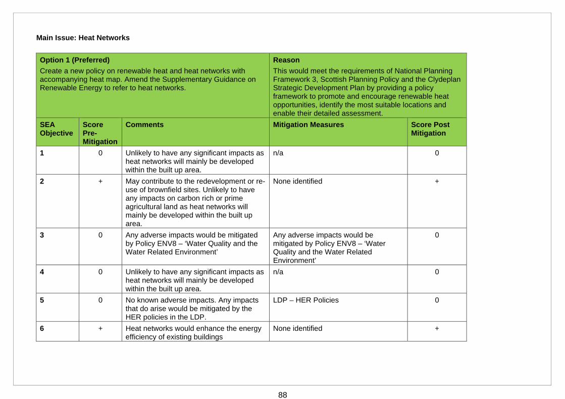
88
Main Issue: Heat Networks
Option 1 (Preferred)
Create a new policy on renewable heat and heat networks with accompanying heat map. Amend the Supplementary Guidance on Renewable Energy to refer to heat networks.
Reason
This would meet the requirements of National Planning Framework 3, Scottish Planning Policy and the Clydeplan Strategic Development Plan by providing a policy framework to promote and encourage renewable heat opportunities, identify the most suitable locations and enable their detailed assessment.
SEA Objective
Score Pre-Mitigation
Comments Mitigation Measures Score Post Mitigation
1 0 Unlikely to have any significant impacts as heat networks will mainly be developed within the built up area.
n/a 0
2 + May contribute to the redevelopment or re-use of brownfield sites. Unlikely to have any impacts on carbon rich or prime agricultural land as heat networks will mainly be developed within the built up area.
None identified +
3 0 Any adverse impacts would be mitigated by Policy ENV8 – ‘Water Quality and the Water Related Environment’
Any adverse impacts would be mitigated by Policy ENV8 – ‘Water Quality and the Water Related Environment’
0
4 0 Unlikely to have any significant impacts as heat networks will mainly be developed within the built up area.
n/a 0
5 0 No known adverse impacts. Any impacts that do arise would be mitigated by the HER policies in the LDP.
LDP – HER Policies 0
6 + Heat networks would enhance the energy efficiency of existing buildings
None identified +
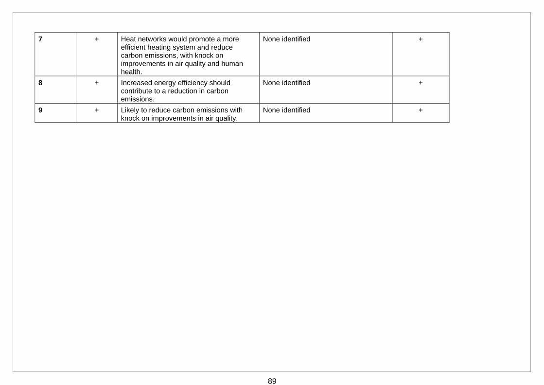
89
7 + Heat networks would promote a more efficient heating system and reduce carbon emissions, with knock on improvements in air quality and human health.
None identified +
8 + Increased energy efficiency should contribute to a reduction in carbon emissions.
None identified +
9 + Likely to reduce carbon emissions with knock on improvements in air quality.
None identified +
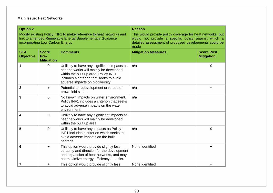
90
Main Issue: Heat Networks
Option 2
Modify existing Policy INF1 to make reference to heat networks and link to amended Renewable Energy Supplementary Guidance incorporating Low Carbon Energy
Reason
This would provide policy coverage for heat networks, but would not provide a specific policy against which a detailed assessment of proposed developments could be made
SEA Objective
Score Pre-Mitigation
Comments Mitigation Measures Score Post Mitigation
1 0 Unlikely to have any significant impacts as heat networks will mainly be developed within the built up area. Policy INF1 includes a criterion that seeks to avoid adverse impacts on biodiversity.
n/a 0
2 + Potential to redevelopment or re-use of brownfield sites.
n/a +
3 0 No known impacts on water environment. Policy INF1 includes a criterion that seeks to avoid adverse impacts on the water environment.
n/a
4 0 Unlikely to have any significant impacts as heat networks will mainly be developed within the built up area.
5 0 Unlikely to have any impacts as Policy INF1 includes a criterion which seeks to avoid adverse impacts on the built heritage.
n/a 0
6 + This option would provide slightly less certainty and direction for the development and expansion of heat networks, and may not maximize energy efficiency benefits.
None identified +
7 + This option would provide slightly less None identified +
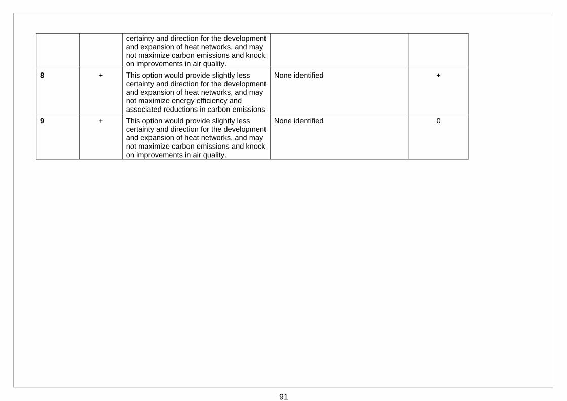
91
certainty and direction for the development and expansion of heat networks, and may not maximize carbon emissions and knock on improvements in air quality.
8 + This option would provide slightly less certainty and direction for the development and expansion of heat networks, and may not maximize energy efficiency and associated reductions in carbon emissions
None identified +
9 + This option would provide slightly less certainty and direction for the development and expansion of heat networks, and may not maximize carbon emissions and knock on improvements in air quality.
None identified 0
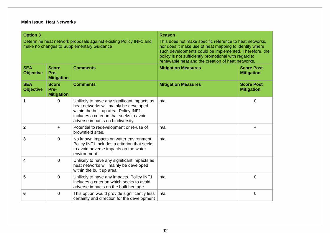
92
Main Issue: Heat Networks
Option 3
Determine heat network proposals against existing Policy INF1 and make no changes to Supplementary Guidance
Reason
This does not make specific reference to heat networks, nor does it make use of heat mapping to identify where such developments could be implemented. Therefore, the policy is not sufficiently promotional with regard to renewable heat and the creation of heat networks.
SEA Objective
Score Pre-Mitigation
Comments Mitigation Measures Score Post Mitigation
SEA Objective
Score Pre-Mitigation
Comments Mitigation Measures Score Post Mitigation
1 0 Unlikely to have any significant impacts as heat networks will mainly be developed within the built up area. Policy INF1 includes a criterion that seeks to avoid adverse impacts on biodiversity.
n/a 0
2 + Potential to redevelopment or re-use of brownfield sites.
n/a +
3 0 No known impacts on water environment. Policy INF1 includes a criterion that seeks to avoid adverse impacts on the water environment.
n/a
4 0 Unlikely to have any significant impacts as heat networks will mainly be developed within the built up area.
5 0 Unlikely to have any impacts. Policy INF1 includes a criterion which seeks to avoid adverse impacts on the built heritage.
n/a 0
6 0 This option would provide significantly less certainty and direction for the development
n/a 0
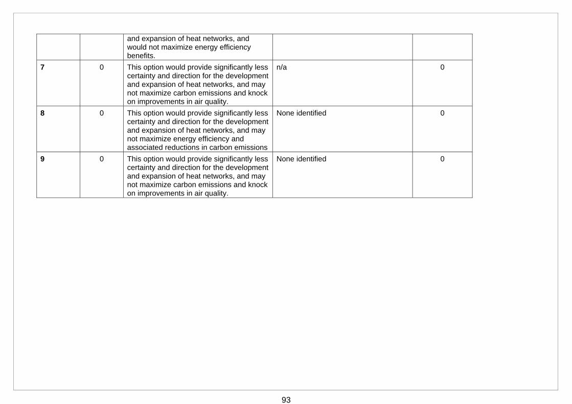
93
and expansion of heat networks, and would not maximize energy efficiency benefits.
7 0 This option would provide significantly less certainty and direction for the development and expansion of heat networks, and may not maximize carbon emissions and knock on improvements in air quality.
n/a 0
8 0 This option would provide significantly less certainty and direction for the development and expansion of heat networks, and may not maximize energy efficiency and associated reductions in carbon emissions
None identified 0
9 0 This option would provide significantly less certainty and direction for the development and expansion of heat networks, and may not maximize carbon emissions and knock on improvements in air quality.
None identified 0
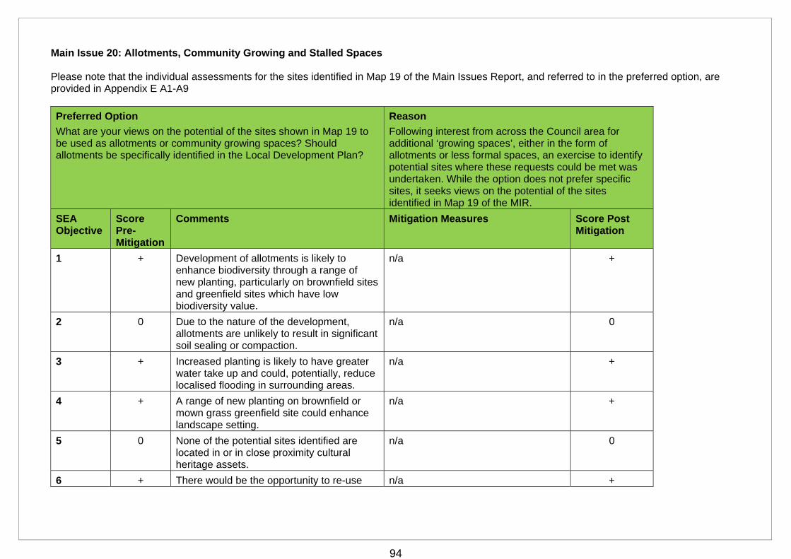
94
Main Issue 20: Allotments, Community Growing and Stalled Spaces Please note that the individual assessments for the sites identified in Map 19 of the Main Issues Report, and referred to in the preferred option, are provided in Appendix E A1-A9
Preferred Option
What are your views on the potential of the sites shown in Map 19 to be used as allotments or community growing spaces? Should allotments be specifically identified in the Local Development Plan?
Reason
Following interest from across the Council area for additional ‘growing spaces’, either in the form of allotments or less formal spaces, an exercise to identify potential sites where these requests could be met was undertaken. While the option does not prefer specific sites, it seeks views on the potential of the sites identified in Map 19 of the MIR.
SEA Objective
Score Pre-Mitigation
Comments Mitigation Measures Score Post Mitigation
1 + Development of allotments is likely to enhance biodiversity through a range of new planting, particularly on brownfield sites and greenfield sites which have low biodiversity value.
n/a +
2 0 Due to the nature of the development, allotments are unlikely to result in significant soil sealing or compaction.
n/a 0
3 + Increased planting is likely to have greater water take up and could, potentially, reduce localised flooding in surrounding areas.
n/a +
4 + A range of new planting on brownfield or mown grass greenfield site could enhance landscape setting.
n/a +
5 0 None of the potential sites identified are located in or in close proximity cultural heritage assets.
n/a 0
6 + There would be the opportunity to re-use n/a +
95
previously developed land.
7 + The provision of allotments would meet an identified community need. As a form of outdoor recreation, allotments would also have positive impacts on human health
n/a +
8 0 No significant impact identified. n/a 0
9 0 No significant impact identified. n/a 0
96
Main Issue 24: Kilmacolm Village Centre Parking
Please note that individual assessments for the proposed sites, which are referred to in the preferred option below and identified in Map 22 of the MIR, are presented in Appendix E (sites 004 – 007)
Preferred Option
Do you agree that there is a need for additional long stay car parking capacity in Kilmacolm? If yes, which of the proposed sites are suitable and why? Do you have an alternative approach to suggest?
Reason
Through the Call for Sites exercise, Kilmacolm Civic Trust has identified long stay parking as an issue that causes difficulty and frustration for residents, businesses and visitors to Kilmacolm. The Civic Trust proposes the construction of up to four long stay car parks in or near Kilmacolm village centre. The proposed sites are identified in Map 22.
SEA Objective
Score Pre-Mitigation
Comments Mitigation Measures Score Post Mitigation
1 -/? Adverse impacts from development of greenfield sites 005 Smithy Brae1 and 006 Smithy Brae 2 (both greenfield). .
Impact on protected species not known.
Extended Phase 1 Habitat survey -/?
2 - Development of the greenfield sites (005 – 006) would have an adverse impact through soil sealing and compaction.
None identified -
3 - Potential fluvial flood risk on both these sites.
Surface water and fluvial flood risk adjacent to the Smithy Brae 2 site.
Flood Risk Assessment 0
4 0 Unlikely to have any significant impacts as proposals are for car parks within the built up area.
n/a 0
5 0 No known impacts on cultural heritage assets
n/a 0
6 - Development of sites 005-006 would reduce the amount of greenfield land.
None identified -
97
7 0 No significant impacts identified n/a 0
8 0 New car parks are likely to cater for existing car journeys and should not increase car travel and associated emissions
n/a 0
9 0 Short term adverse impact through the release of particulate matter (dust) during construction, but this is unlikely to lead to the designation of an Air Quality Management Area
n/a 0
Cumulative/Synergistic Effects:
Mitigation Required Stage Responsible
Flood Risk Assessment Planning application Developer
Extended Phase 1 Habitat Survey
Planning application Developer
Further information on potential to deculvert watercourse.
Planning application Developer
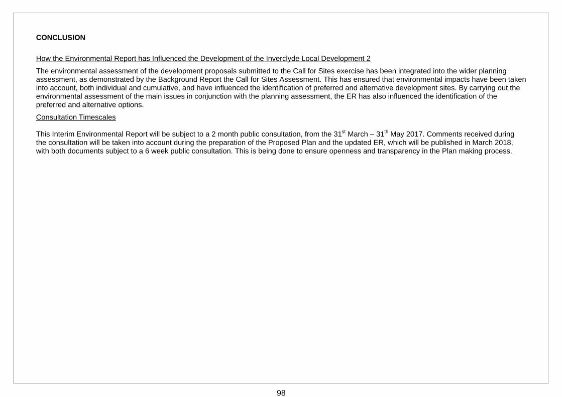
98
CONCLUSION
How the Environmental Report has Influenced the Development of the Inverclyde Local Development 2
The environmental assessment of the development proposals submitted to the Call for Sites exercise has been integrated into the wider planning assessment, as demonstrated by the Background Report the Call for Sites Assessment. This has ensured that environmental impacts have been taken into account, both individual and cumulative, and have influenced the identification of preferred and alternative development sites. By carrying out the environmental assessment of the main issues in conjunction with the planning assessment, the ER has also influenced the identification of the preferred and alternative options.
Consultation Timescales This Interim Environmental Report will be subject to a 2 month public consultation, from the 31st March – 31th May 2017. Comments received during the consultation will be taken into account during the preparation of the Proposed Plan and the updated ER, which will be published in March 2018, with both documents subject to a 6 week public consultation. This is being done to ensure openness and transparency in the Plan making process.
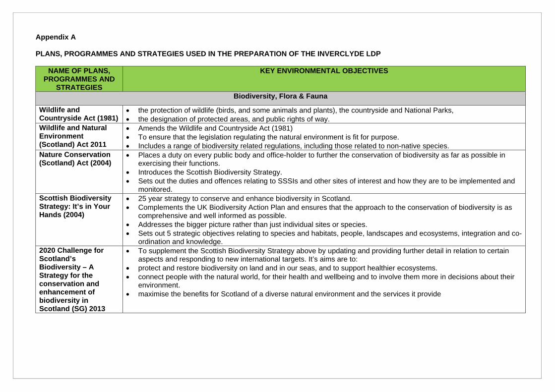
Appendix A PLANS, PROGRAMMES AND STRATEGIES USED IN THE PREPARATION OF THE INVERCLYDE LDP
NAME OF PLANS, PROGRAMMES AND
STRATEGIES
KEY ENVIRONMENTAL OBJECTIVES
Biodiversity, Flora & Fauna
Wildlife and Countryside Act (1981)
the protection of wildlife (birds, and some animals and plants), the countryside and National Parks, the designation of protected areas, and public rights of way.
Wildlife and Natural Environment (Scotland) Act 2011
Amends the Wildlife and Countryside Act (1981) To ensure that the legislation regulating the natural environment is fit for purpose. Includes a range of biodiversity related regulations, including those related to non-native species.
Nature Conservation (Scotland) Act (2004)
Places a duty on every public body and office-holder to further the conservation of biodiversity as far as possible in exercising their functions.
Introduces the Scottish Biodiversity Strategy. Sets out the duties and offences relating to SSSIs and other sites of interest and how they are to be implemented and
monitored. Scottish Biodiversity Strategy: It’s in Your Hands (2004)
25 year strategy to conserve and enhance biodiversity in Scotland. Complements the UK Biodiversity Action Plan and ensures that the approach to the conservation of biodiversity is as
comprehensive and well informed as possible. Addresses the bigger picture rather than just individual sites or species. Sets out 5 strategic objectives relating to species and habitats, people, landscapes and ecosystems, integration and co-
ordination and knowledge. 2020 Challenge for Scotland’s Biodiversity – A Strategy for the conservation and enhancement of biodiversity in Scotland (SG) 2013
To supplement the Scottish Biodiversity Strategy above by updating and providing further detail in relation to certain aspects and responding to new international targets. It’s aims are to:
protect and restore biodiversity on land and in our seas, and to support healthier ecosystems. connect people with the natural world, for their health and wellbeing and to involve them more in decisions about their
environment. maximise the benefits for Scotland of a diverse natural environment and the services it provide
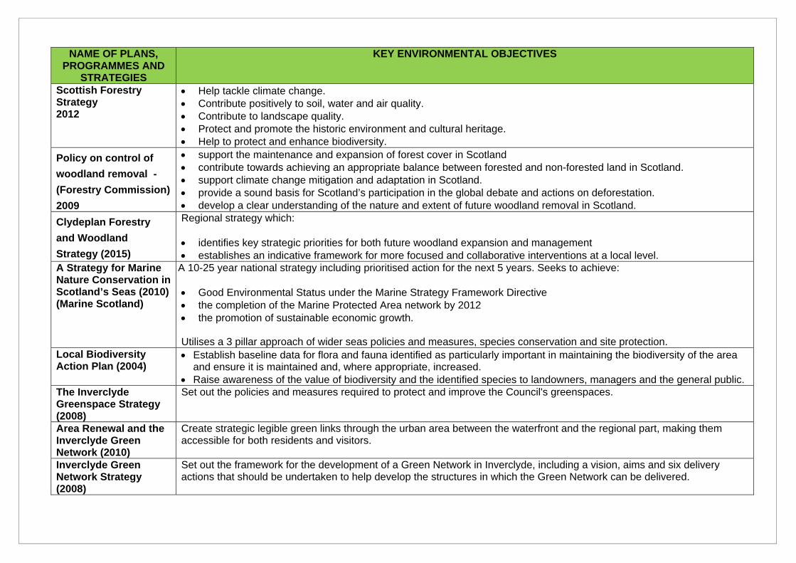
NAME OF PLANS, PROGRAMMES AND
STRATEGIES
KEY ENVIRONMENTAL OBJECTIVES
Scottish Forestry Strategy 2012
Help tackle climate change. Contribute positively to soil, water and air quality. Contribute to landscape quality. Protect and promote the historic environment and cultural heritage. Help to protect and enhance biodiversity.
Policy on control of
woodland removal -
(Forestry Commission)
2009
support the maintenance and expansion of forest cover in Scotland contribute towards achieving an appropriate balance between forested and non-forested land in Scotland. support climate change mitigation and adaptation in Scotland. provide a sound basis for Scotland’s participation in the global debate and actions on deforestation. develop a clear understanding of the nature and extent of future woodland removal in Scotland.
Clydeplan Forestry
and Woodland
Strategy (2015)
Regional strategy which: identifies key strategic priorities for both future woodland expansion and management establishes an indicative framework for more focused and collaborative interventions at a local level.
A Strategy for Marine Nature Conservation in Scotland’s Seas (2010) (Marine Scotland)
A 10-25 year national strategy including prioritised action for the next 5 years. Seeks to achieve: Good Environmental Status under the Marine Strategy Framework Directive the completion of the Marine Protected Area network by 2012 the promotion of sustainable economic growth. Utilises a 3 pillar approach of wider seas policies and measures, species conservation and site protection.
Local Biodiversity Action Plan (2004)
Establish baseline data for flora and fauna identified as particularly important in maintaining the biodiversity of the area and ensure it is maintained and, where appropriate, increased.
Raise awareness of the value of biodiversity and the identified species to landowners, managers and the general public. The Inverclyde Greenspace Strategy (2008)
Set out the policies and measures required to protect and improve the Council's greenspaces.
Area Renewal and the Inverclyde Green Network (2010)
Create strategic legible green links through the urban area between the waterfront and the regional part, making them accessible for both residents and visitors.
Inverclyde Green Network Strategy (2008)
Set out the framework for the development of a Green Network in Inverclyde, including a vision, aims and six delivery actions that should be undertaken to help develop the structures in which the Green Network can be delivered.
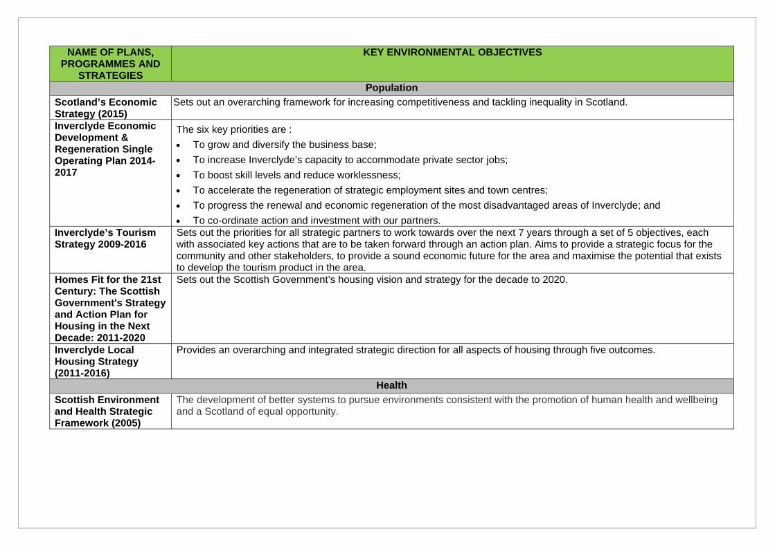
NAME OF PLANS, PROGRAMMES AND
STRATEGIES
KEY ENVIRONMENTAL OBJECTIVES
Population
Scotland’s Economic Strategy (2015)
Sets out an overarching framework for increasing competitiveness and tackling inequality in Scotland.
Inverclyde Economic Development & Regeneration Single Operating Plan 2014-2017
The six key priorities are :
To grow and diversify the business base;
To increase Inverclyde’s capacity to accommodate private sector jobs;
To boost skill levels and reduce worklessness;
To accelerate the regeneration of strategic employment sites and town centres;
To progress the renewal and economic regeneration of the most disadvantaged areas of Inverclyde; and
To co-ordinate action and investment with our partners. Inverclyde’s Tourism Strategy 2009-2016
Sets out the priorities for all strategic partners to work towards over the next 7 years through a set of 5 objectives, each with associated key actions that are to be taken forward through an action plan. Aims to provide a strategic focus for the community and other stakeholders, to provide a sound economic future for the area and maximise the potential that exists to develop the tourism product in the area.
Homes Fit for the 21st Century: The Scottish Government's Strategy and Action Plan for Housing in the Next Decade: 2011-2020
Sets out the Scottish Government’s housing vision and strategy for the decade to 2020.
Inverclyde Local Housing Strategy (2011-2016)
Provides an overarching and integrated strategic direction for all aspects of housing through five outcomes.
Health
Scottish Environment and Health Strategic Framework (2005)
The development of better systems to pursue environments consistent with the promotion of human health and wellbeing and a Scotland of equal opportunity.
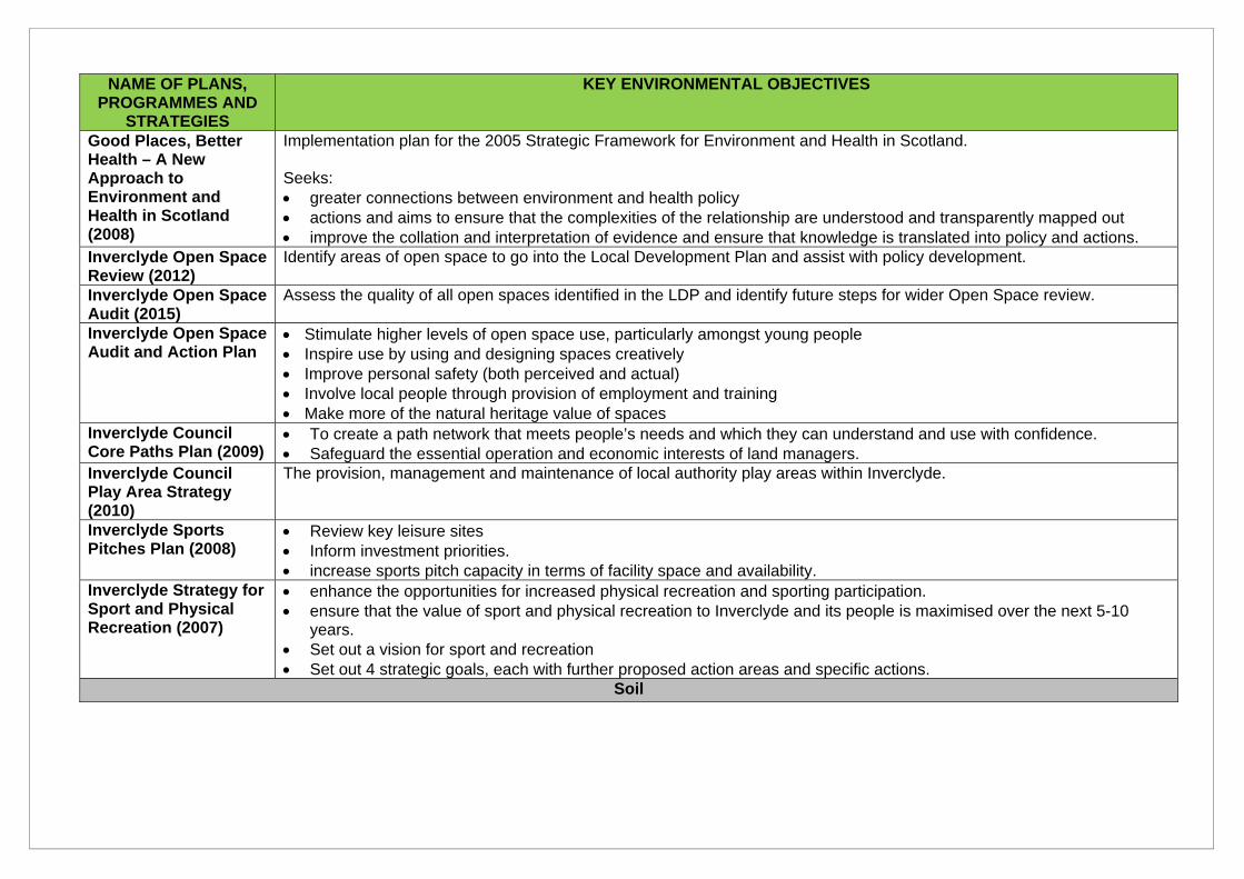
NAME OF PLANS, PROGRAMMES AND
STRATEGIES
KEY ENVIRONMENTAL OBJECTIVES
Good Places, Better Health – A New Approach to Environment and Health in Scotland (2008)
Implementation plan for the 2005 Strategic Framework for Environment and Health in Scotland. Seeks: greater connections between environment and health policy actions and aims to ensure that the complexities of the relationship are understood and transparently mapped out improve the collation and interpretation of evidence and ensure that knowledge is translated into policy and actions.
Inverclyde Open Space Review (2012)
Identify areas of open space to go into the Local Development Plan and assist with policy development.
Inverclyde Open Space Audit (2015)
Assess the quality of all open spaces identified in the LDP and identify future steps for wider Open Space review.
Inverclyde Open Space Audit and Action Plan
Stimulate higher levels of open space use, particularly amongst young people Inspire use by using and designing spaces creatively Improve personal safety (both perceived and actual) Involve local people through provision of employment and training Make more of the natural heritage value of spaces
Inverclyde Council Core Paths Plan (2009)
To create a path network that meets people’s needs and which they can understand and use with confidence. Safeguard the essential operation and economic interests of land managers.
Inverclyde Council Play Area Strategy (2010)
The provision, management and maintenance of local authority play areas within Inverclyde.
Inverclyde Sports Pitches Plan (2008)
Review key leisure sites Inform investment priorities. increase sports pitch capacity in terms of facility space and availability.
Inverclyde Strategy for Sport and Physical Recreation (2007)
enhance the opportunities for increased physical recreation and sporting participation. ensure that the value of sport and physical recreation to Inverclyde and its people is maximised over the next 5-10
years. Set out a vision for sport and recreation Set out 4 strategic goals, each with further proposed action areas and specific actions.
Soil
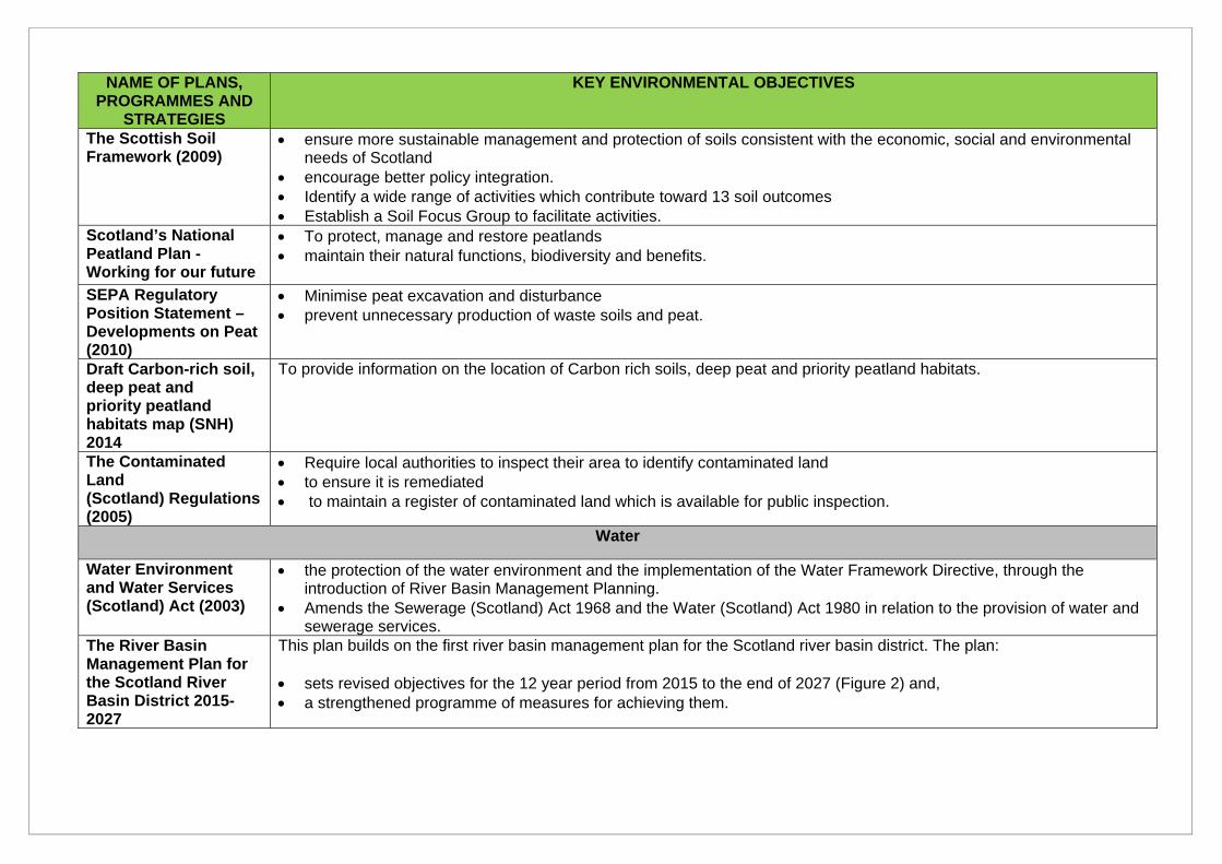
NAME OF PLANS, PROGRAMMES AND
STRATEGIES
KEY ENVIRONMENTAL OBJECTIVES
The Scottish Soil Framework (2009)
ensure more sustainable management and protection of soils consistent with the economic, social and environmental needs of Scotland
encourage better policy integration. Identify a wide range of activities which contribute toward 13 soil outcomes Establish a Soil Focus Group to facilitate activities.
Scotland’s National Peatland Plan - Working for our future
To protect, manage and restore peatlands maintain their natural functions, biodiversity and benefits.
SEPA Regulatory Position Statement – Developments on Peat (2010)
Minimise peat excavation and disturbance prevent unnecessary production of waste soils and peat.
Draft Carbon-rich soil, deep peat and priority peatland habitats map (SNH) 2014
To provide information on the location of Carbon rich soils, deep peat and priority peatland habitats.
The Contaminated Land (Scotland) Regulations (2005)
Require local authorities to inspect their area to identify contaminated land to ensure it is remediated to maintain a register of contaminated land which is available for public inspection.
Water
Water Environment and Water Services (Scotland) Act (2003)
the protection of the water environment and the implementation of the Water Framework Directive, through the introduction of River Basin Management Planning.
Amends the Sewerage (Scotland) Act 1968 and the Water (Scotland) Act 1980 in relation to the provision of water and sewerage services.
The River Basin Management Plan for the Scotland River Basin District 2015-2027
This plan builds on the first river basin management plan for the Scotland river basin district. The plan: sets revised objectives for the 12 year period from 2015 to the end of 2027 (Figure 2) and, a strengthened programme of measures for achieving them.
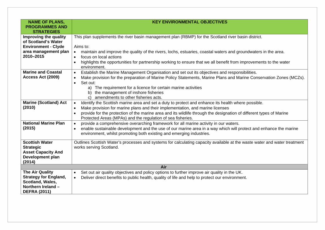
NAME OF PLANS, PROGRAMMES AND
STRATEGIES
KEY ENVIRONMENTAL OBJECTIVES
Improving the quality of Scotland’s Water Environment - Clyde area management plan 2010–2015
This plan supplements the river basin management plan (RBMP) for the Scotland river basin district. Aims to: maintain and improve the quality of the rivers, lochs, estuaries, coastal waters and groundwaters in the area. focus on local actions highlights the opportunities for partnership working to ensure that we all benefit from improvements to the water
environment. Marine and Coastal Access Act (2009)
Establish the Marine Management Organisation and set out its objectives and responsibilities. Make provision for the preparation of Marine Policy Statements, Marine Plans and Marine Conservation Zones (MCZs). Set out:
a) The requirement for a licence for certain marine activities b) the management of inshore fisheries c) amendments to other fisheries acts.
Marine (Scotland) Act (2010)
Identify the Scottish marine area and set a duty to protect and enhance its health where possible. Make provision for marine plans and their implementation, and marine licenses provide for the protection of the marine area and its wildlife through the designation of different types of Marine
Protected Areas (MPAs) and the regulation of sea fisheries. National Marine Plan (2015)
provide a comprehensive overarching framework for all marine activity in our waters. enable sustainable development and the use of our marine area in a way which will protect and enhance the marine
environment, whilst promoting both existing and emerging industries.
Scottish Water Strategic Asset Capacity And Development plan (2014)
Outlines Scottish Water’s processes and systems for calculating capacity available at the waste water and water treatment works serving Scotland.
Air The Air Quality Strategy for England, Scotland, Wales, Northern Ireland – DEFRA (2011)
Set out air quality objectives and policy options to further improve air quality in the UK. Deliver direct benefits to public health, quality of life and help to protect our environment.
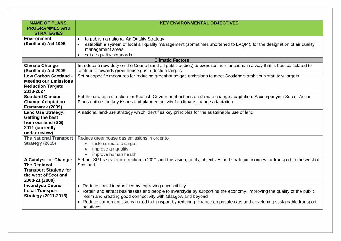
NAME OF PLANS, PROGRAMMES AND
STRATEGIES
KEY ENVIRONMENTAL OBJECTIVES
Environment (Scotland) Act 1995
to publish a national Air Quality Strategy establish a system of local air quality management (sometimes shortened to LAQM), for the designation of air quality
management areas. set air quality standards.
Climatic Factors Climate Change (Scotland) Act 2009
Introduce a new duty on the Council (and all public bodies) to exercise their functions in a way that is best calculated to contribute towards greenhouse gas reduction targets.
Low Carbon Scotland - Meeting our Emissions Reduction Targets 2013-2027
Set out specific measures for reducing greenhouse gas emissions to meet Scotland's ambitious statutory targets.
Scotland Climate Change Adaptation Framework (2009)
Set the strategic direction for Scottish Government actions on climate change adaptation. Accompanying Sector Action Plans outline the key issues and planned activity for climate change adaptation
Land Use Strategy: Getting the best from our land (SG) 2011 (currently under review)
A national land-use strategy which identifies key principles for the sustainable use of land
The National Transport Strategy (2015)
Reduce greenhouse gas emissions in order to: tackle climate change improve air quality improve human health
A Catalyst for Change: The Regional Transport Strategy for the west of Scotland 2008-21 (2008)
Set out SPT’s strategic direction to 2021 and the vision, goals, objectives and strategic priorities for transport in the west of Scotland.
Inverclyde Council Local Transport Strategy (2011-2016)
Reduce social inequalities by improving accessibility Retain and attract businesses and people to Inverclyde by supporting the economy, improving the quality of the public
realm and creating good connectivity with Glasgow and beyond Reduce carbon emissions linked to transport by reducing reliance on private cars and developing sustainable transport
solutions
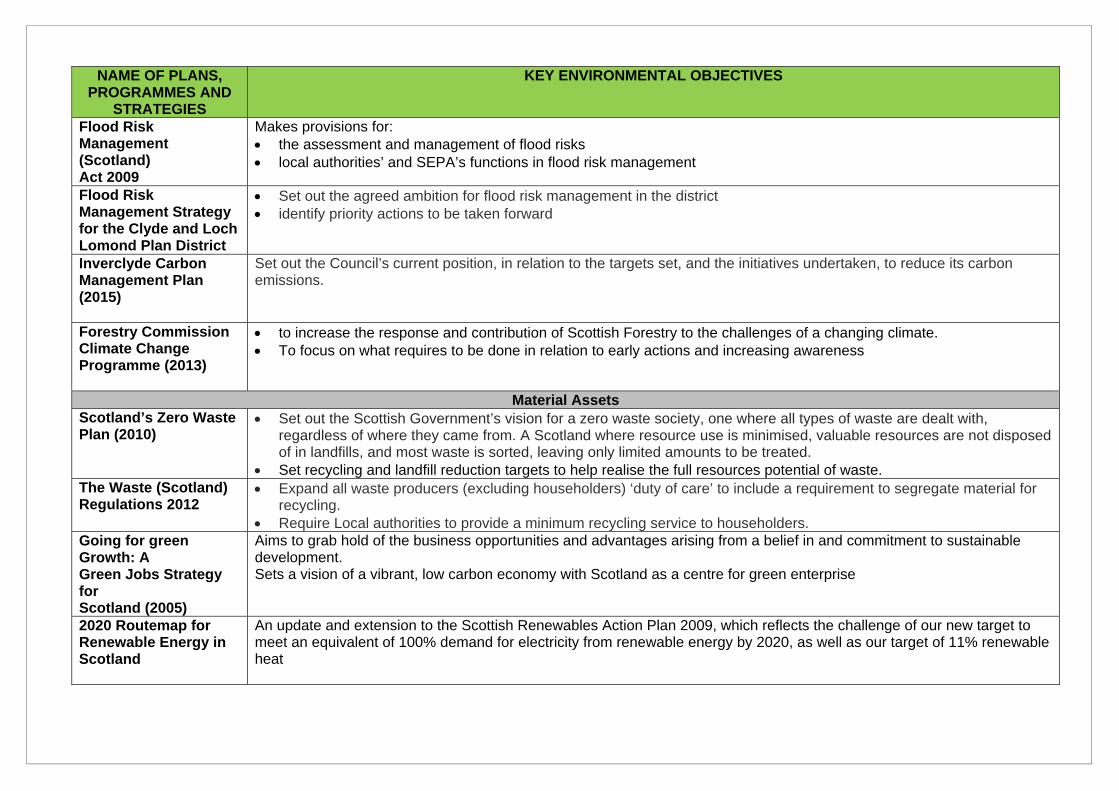
NAME OF PLANS, PROGRAMMES AND
STRATEGIES
KEY ENVIRONMENTAL OBJECTIVES
Flood Risk Management (Scotland) Act 2009
Makes provisions for: the assessment and management of flood risks local authorities’ and SEPA’s functions in flood risk management
Flood Risk Management Strategy for the Clyde and Loch Lomond Plan District
Set out the agreed ambition for flood risk management in the district identify priority actions to be taken forward
Inverclyde Carbon Management Plan (2015)
Set out the Council’s current position, in relation to the targets set, and the initiatives undertaken, to reduce its carbon emissions.
Forestry Commission Climate Change Programme (2013)
to increase the response and contribution of Scottish Forestry to the challenges of a changing climate. To focus on what requires to be done in relation to early actions and increasing awareness
Material Assets Scotland’s Zero Waste Plan (2010)
Set out the Scottish Government’s vision for a zero waste society, one where all types of waste are dealt with, regardless of where they came from. A Scotland where resource use is minimised, valuable resources are not disposed of in landfills, and most waste is sorted, leaving only limited amounts to be treated.
Set recycling and landfill reduction targets to help realise the full resources potential of waste. The Waste (Scotland) Regulations 2012
Expand all waste producers (excluding householders) ‘duty of care’ to include a requirement to segregate material for recycling.
Require Local authorities to provide a minimum recycling service to householders. Going for green Growth: A Green Jobs Strategy for Scotland (2005)
Aims to grab hold of the business opportunities and advantages arising from a belief in and commitment to sustainable development. Sets a vision of a vibrant, low carbon economy with Scotland as a centre for green enterprise
2020 Routemap for Renewable Energy in Scotland
An update and extension to the Scottish Renewables Action Plan 2009, which reflects the challenge of our new target to meet an equivalent of 100% demand for electricity from renewable energy by 2020, as well as our target of 11% renewable heat
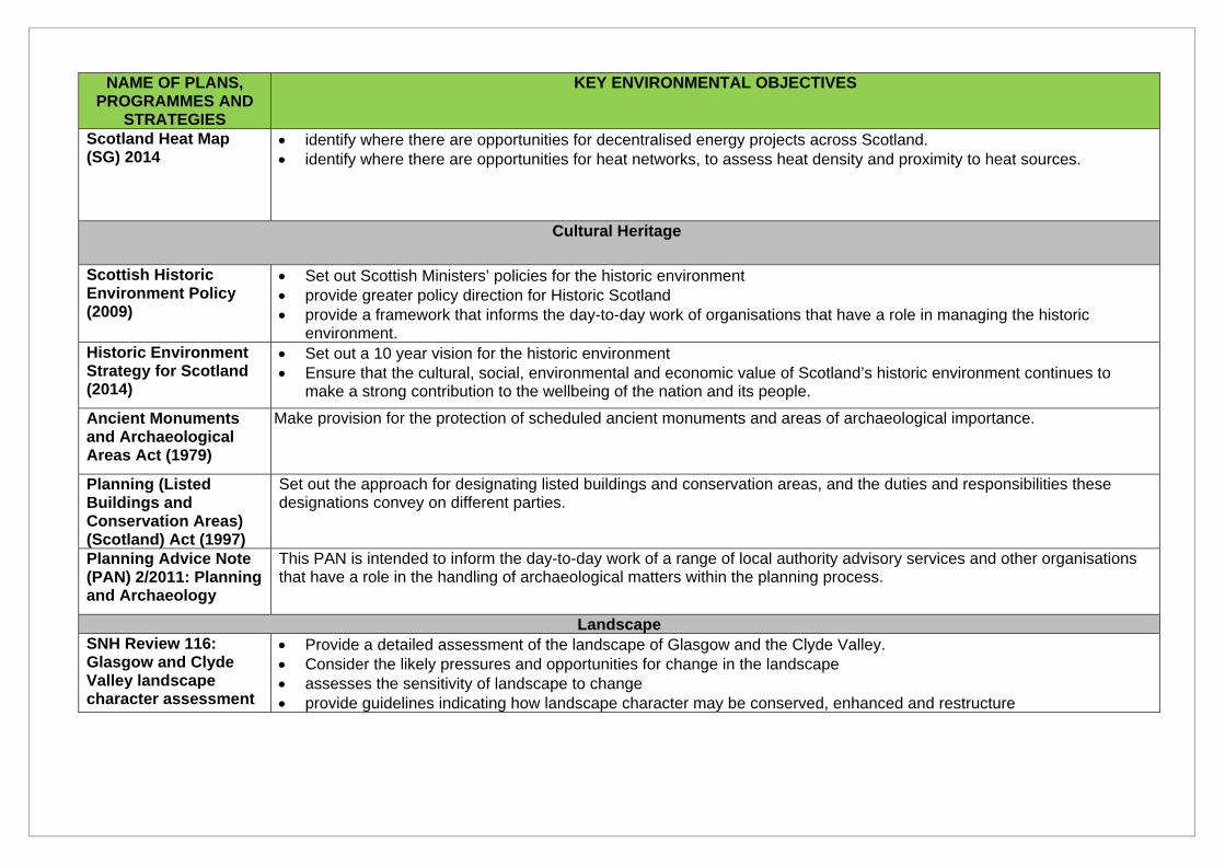
NAME OF PLANS, PROGRAMMES AND
STRATEGIES
KEY ENVIRONMENTAL OBJECTIVES
Scotland Heat Map (SG) 2014
identify where there are opportunities for decentralised energy projects across Scotland. identify where there are opportunities for heat networks, to assess heat density and proximity to heat sources.
Cultural Heritage
Scottish Historic Environment Policy (2009)
Set out Scottish Ministers’ policies for the historic environment provide greater policy direction for Historic Scotland provide a framework that informs the day-to-day work of organisations that have a role in managing the historic
environment. Historic Environment Strategy for Scotland (2014)
Set out a 10 year vision for the historic environment Ensure that the cultural, social, environmental and economic value of Scotland’s historic environment continues to
make a strong contribution to the wellbeing of the nation and its people.
Ancient Monuments and Archaeological Areas Act (1979)
Make provision for the protection of scheduled ancient monuments and areas of archaeological importance.
Planning (Listed Buildings and Conservation Areas) (Scotland) Act (1997)
Set out the approach for designating listed buildings and conservation areas, and the duties and responsibilities these designations convey on different parties.
Planning Advice Note (PAN) 2/2011: Planning and Archaeology
This PAN is intended to inform the day-to-day work of a range of local authority advisory services and other organisations that have a role in the handling of archaeological matters within the planning process.
Landscape SNH Review 116: Glasgow and Clyde Valley landscape character assessment
Provide a detailed assessment of the landscape of Glasgow and the Clyde Valley. Consider the likely pressures and opportunities for change in the landscape assesses the sensitivity of landscape to change provide guidelines indicating how landscape character may be conserved, enhanced and restructure
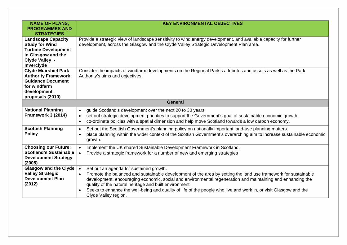
NAME OF PLANS, PROGRAMMES AND
STRATEGIES
KEY ENVIRONMENTAL OBJECTIVES
Landscape Capacity Study for Wind Turbine Development in Glasgow and the Clyde Valley - Inverclyde
Provide a strategic view of landscape sensitivity to wind energy development, and available capacity for further development, across the Glasgow and the Clyde Valley Strategic Development Plan area.
Clyde Muirshiel Park Authority Framework Guidance Document for windfarm development proposals (2010)
Consider the impacts of windfarm developments on the Regional Park’s attributes and assets as well as the Park Authority’s aims and objectives.
General
National Planning Framework 3 (2014)
guide Scotland’s development over the next 20 to 30 years set out strategic development priorities to support the Government’s goal of sustainable economic growth. co-ordinate policies with a spatial dimension and help move Scotland towards a low carbon economy.
Scottish Planning Policy
Set out the Scottish Government's planning policy on nationally important land-use planning matters. place planning within the wider context of the Scottish Government’s overarching aim to increase sustainable economic
growth.
Choosing our Future: Scotland’s Sustainable Development Strategy (2005)
Implement the UK shared Sustainable Development Framework in Scotland. Provide a strategic framework for a number of new and emerging strategies
Glasgow and the Clyde Valley Strategic Development Plan (2012)
Set out an agenda for sustained growth. Promote the balanced and sustainable development of the area by setting the land use framework for sustainable
development, encouraging economic, social and environmental regeneration and maintaining and enhancing the quality of the natural heritage and built environment
Seeks to enhance the well-being and quality of life of the people who live and work in, or visit Glasgow and the Clyde Valley region.
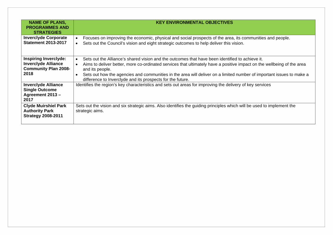
NAME OF PLANS, PROGRAMMES AND
STRATEGIES
KEY ENVIRONMENTAL OBJECTIVES
Inverclyde Corporate Statement 2013-2017
Focuses on improving the economic, physical and social prospects of the area, its communities and people. Sets out the Council’s vision and eight strategic outcomes to help deliver this vision.
Inspiring Inverclyde: Inverclyde Alliance Community Plan 2008-2018
Sets out the Alliance’s shared vision and the outcomes that have been identified to achieve it. Aims to deliver better, more co-ordinated services that ultimately have a positive impact on the wellbeing of the area
and its people. Sets out how the agencies and communities in the area will deliver on a limited number of important issues to make a
difference to Inverclyde and its prospects for the future. Inverclyde Alliance Single Outcome Agreement 2013 – 2017
Identifies the region’s key characteristics and sets out areas for improving the delivery of key services
Clyde Muirshiel Park Authority Park Strategy 2008-2011
Sets out the vision and six strategic aims. Also identifies the guiding principles which will be used to implement the strategic aims.
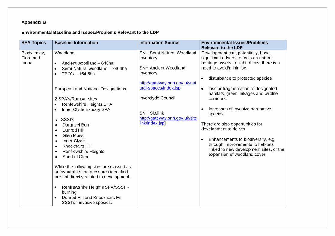
Appendix B Environmental Baseline and Issues/Problems Relevant to the LDP SEA Topics Baseline Information Information Source Environmental Issues/Problems
Relevant to the LDP Biodviersity, Flora and fauna
Woodland Ancient woodland – 648ha Semi-Natural woodland – 2404ha TPO’s – 154.5ha European and National Designations 2 SPA’s/Ramsar sites Renfewshire Heights SPA Inner Clyde Estuary SPA 7 SSSI’s Dargavel Burn Dunrod Hill Glen Moss Inner Clyde Knocknairs Hill Renfrewshire Heights Shielhill Glen While the following sites are classed as unfavourable, the pressures identified are not directly related to development. Renfrewshire Heights SPA/SSSI -
burning Dunrod Hill and Knocknairs Hill
SSSI’s - invasive species.
SNH Semi-Natural Woodland Inventory SNH Ancient Woodland Inventory http://gateway.snh.gov.uk/natural-spaces/index.jsp Inverclyde Council SNH Sitelink http://gateway.snh.gov.uk/sitelink/index.jsp]
Development can, potentially, have significant adverse effects on natural heritage assets. In light of this, there is a need to avoid/minimise: disturbance to protected species
loss or fragmentation of designated
habitats, green linkages and wildlife corridors.
Increases of invasive non-native
species
There are also opportunities for development to deliver: Enhancements to biodiversity, e.g.
through improvements to habitats linked to new development sites, or the expansion of woodland cover.
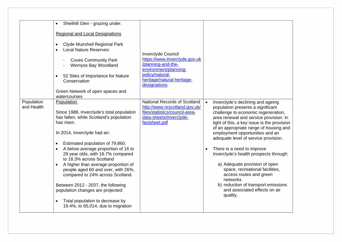
Sheilhill Glen - grazing under. Regional and Local Designations Clyde Muirsheil Regional Park Local Nature Reserves:
‐ Coves Community Park ‐ Wemyss Bay Woodland
52 Sites of Importance for Nature
Conservation Green Network of open spaces and watercourses
Inverclyde Council https://www.inverclyde.gov.uk/planning-and-the-environment/planning-policy/natural-heritage/natural-heritage-designations
Population and Health
Population Since 1988, Inverclyde's total population has fallen, while Scotland's population has risen. In 2014, Inverclyde had an: Estimated population of 79,860. A below average proportion of 16 to
29 year olds, with 16.7% compared to 18.3% across Scotland
A higher than average proportion of people aged 60 and over, with 26%, compared to 24% across Scotland.
Between 2012 - 2037, the following population changes are projected: Total population to decrease by
19.4%, to 65,014, due to migration
National Records of Scotland http://www.nrscotland.gov.uk/files/statistics/council-area-data-sheets/inverclyde-factsheet.pdf
Inverclyde’s declining and ageing population presents a significant challenge to economic regeneration, area renewal and service provision. In light of this, a key issue is the provision of an appropriate range of housing and employment opportunities and an adequate level of service provision.
There is a need to improve Inverclyde’s health prospects through:
a) Adequate provision of open
space, recreational facilities, access routes and green networks
b) reduction of transport emissions and associated effects on air quality.
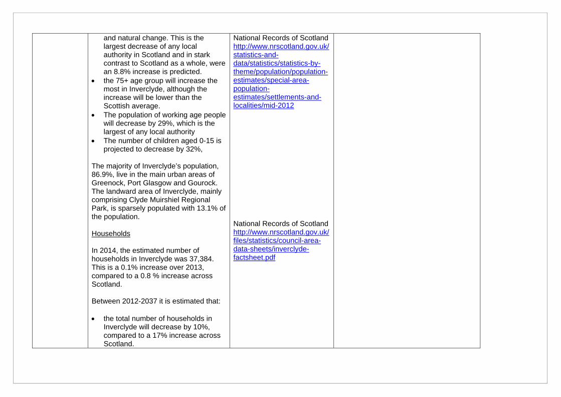
and natural change. This is the largest decrease of any local authority in Scotland and in stark contrast to Scotland as a whole, were an 8.8% increase is predicted.
the 75+ age group will increase the most in Inverclyde, although the increase will be lower than the Scottish average.
The population of working age people will decrease by 29%, which is the largest of any local authority
The number of children aged 0-15 is projected to decrease by 32%,
The majority of Inverclyde’s population, 86.9%, live in the main urban areas of Greenock, Port Glasgow and Gourock. The landward area of Inverclyde, mainly comprising Clyde Muirshiel Regional Park, is sparsely populated with 13.1% of the population. Households In 2014, the estimated number of households in Inverclyde was 37,384. This is a 0.1% increase over 2013, compared to a 0.8 % increase across Scotland. Between 2012-2037 it is estimated that: the total number of households in
Inverclyde will decrease by 10%, compared to a 17% increase across Scotland.
National Records of Scotland http://www.nrscotland.gov.uk/statistics-and-data/statistics/statistics-by-theme/population/population-estimates/special-area-population-estimates/settlements-and-localities/mid-2012 National Records of Scotland http://www.nrscotland.gov.uk/files/statistics/council-area-data-sheets/inverclyde-factsheet.pdf
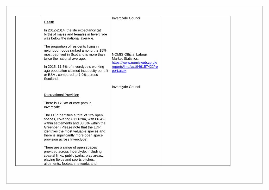
Health In 2012-2014, the life expectancy (at birth) of males and females in Inverclyde was below the national average. The proportion of residents living in neighbourhoods ranked among the 15% most deprived in Scotland is more than twice the national average. In 2015, 11.5% of Inverclyde’s working age population claimed incapacity benefit or ESA , compared to 7.9% across Scotland. Recreational Provision There is 179km of core path in Inverclyde. The LDP identifies a total of 125 open spaces, covering 611.62ha, with 66.4% within settlements and 33.6% within the Greenbelt (Please note that the LDP identifies the most valuable spaces and there is significantly more open space provision across Inverclyde). There are a range of open spaces provided across Inverclyde, including coastal links, public parks, play areas, playing fields and sports pitches, allotments, footpath networks and
Inverclyde Council NOMIS Official Labour Market Statistics. https://www.nomisweb.co.uk/reports/lmp/la/1946157422/report.aspx Inverclyde Council
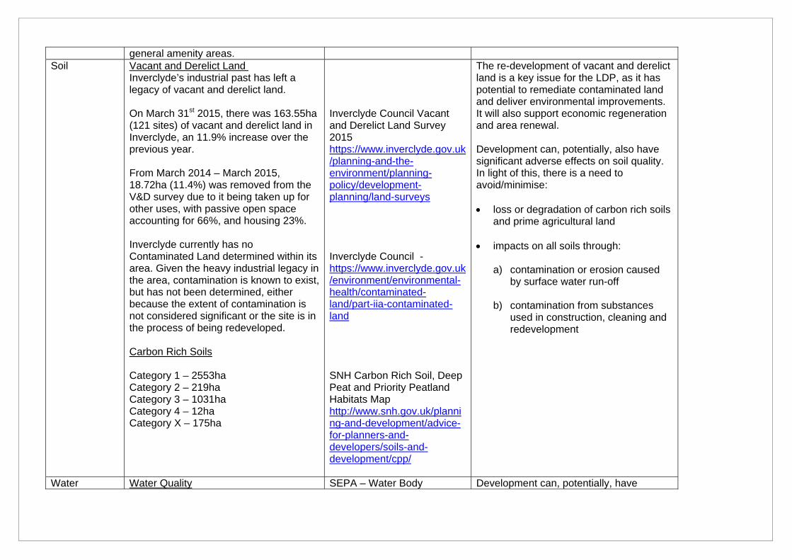
general amenity areas. Soil Vacant and Derelict Land
Inverclyde’s industrial past has left a legacy of vacant and derelict land. On March 31st 2015, there was 163.55ha (121 sites) of vacant and derelict land in Inverclyde, an 11.9% increase over the previous year. From March 2014 – March 2015, 18.72ha (11.4%) was removed from the V&D survey due to it being taken up for other uses, with passive open space accounting for 66%, and housing 23%. Inverclyde currently has no Contaminated Land determined within its area. Given the heavy industrial legacy in the area, contamination is known to exist, but has not been determined, either because the extent of contamination is not considered significant or the site is in the process of being redeveloped. Carbon Rich Soils Category 1 – 2553ha Category 2 – 219ha Category 3 – 1031ha Category 4 – 12ha Category X – 175ha
Inverclyde Council Vacant and Derelict Land Survey 2015 https://www.inverclyde.gov.uk/planning-and-the-environment/planning-policy/development-planning/land-surveys Inverclyde Council - https://www.inverclyde.gov.uk/environment/environmental-health/contaminated-land/part-iia-contaminated-land SNH Carbon Rich Soil, Deep Peat and Priority Peatland Habitats Map http://www.snh.gov.uk/planning-and-development/advice-for-planners-and-developers/soils-and-development/cpp/
The re-development of vacant and derelict land is a key issue for the LDP, as it has potential to remediate contaminated land and deliver environmental improvements. It will also support economic regeneration and area renewal. Development can, potentially, also have significant adverse effects on soil quality. In light of this, there is a need to avoid/minimise: loss or degradation of carbon rich soils
and prime agricultural land
impacts on all soils through:
a) contamination or erosion caused by surface water run-off
b) contamination from substances used in construction, cleaning and redevelopment
Water Water Quality SEPA – Water Body Development can, potentially, have
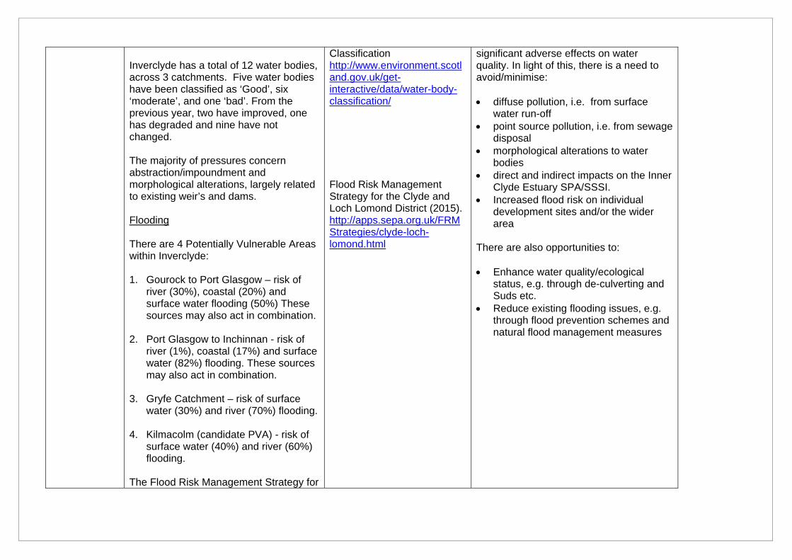
Inverclyde has a total of 12 water bodies, across 3 catchments. Five water bodies have been classified as ‘Good’, six ‘moderate’, and one ‘bad’. From the previous year, two have improved, one has degraded and nine have not changed. The majority of pressures concern abstraction/impoundment and morphological alterations, largely related to existing weir’s and dams. Flooding There are 4 Potentially Vulnerable Areas within Inverclyde: 1. Gourock to Port Glasgow – risk of
river (30%), coastal (20%) and surface water flooding (50%) These sources may also act in combination.
2. Port Glasgow to Inchinnan - risk of river (1%), coastal (17%) and surface water (82%) flooding. These sources may also act in combination.
3. Gryfe Catchment – risk of surface
water (30%) and river (70%) flooding.
4. Kilmacolm (candidate PVA) - risk of surface water (40%) and river (60%) flooding.
The Flood Risk Management Strategy for
Classification http://www.environment.scotland.gov.uk/get-interactive/data/water-body-classification/ Flood Risk Management Strategy for the Clyde and Loch Lomond District (2015). http://apps.sepa.org.uk/FRMStrategies/clyde-loch-lomond.html
significant adverse effects on water quality. In light of this, there is a need to avoid/minimise: diffuse pollution, i.e. from surface
water run-off point source pollution, i.e. from sewage
disposal morphological alterations to water
bodies direct and indirect impacts on the Inner
Clyde Estuary SPA/SSSI. Increased flood risk on individual
development sites and/or the wider area
There are also opportunities to: Enhance water quality/ecological
status, e.g. through de-culverting and Suds etc.
Reduce existing flooding issues, e.g. through flood prevention schemes and natural flood management measures
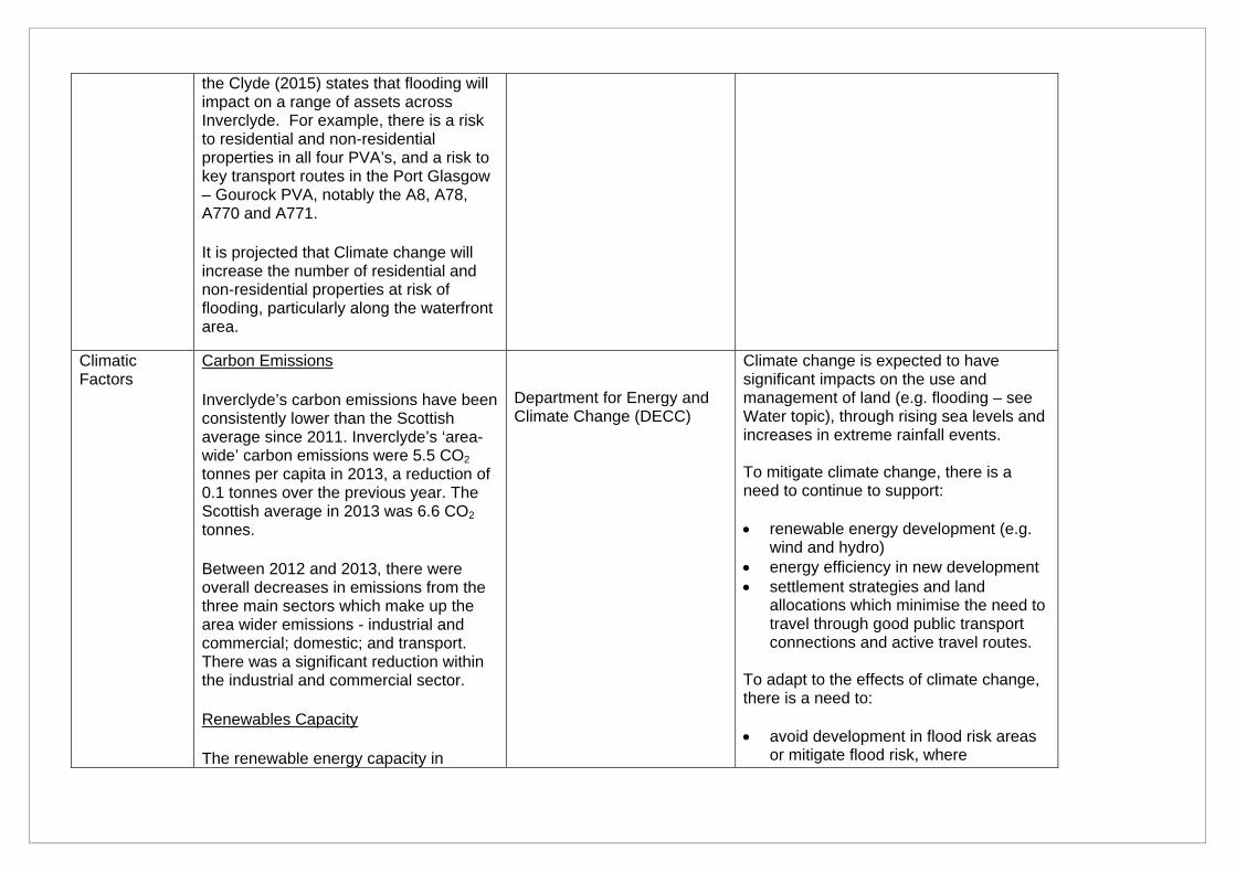
the Clyde (2015) states that flooding will impact on a range of assets across Inverclyde. For example, there is a risk to residential and non-residential properties in all four PVA’s, and a risk to key transport routes in the Port Glasgow – Gourock PVA, notably the A8, A78, A770 and A771.
It is projected that Climate change will increase the number of residential and non-residential properties at risk of flooding, particularly along the waterfront area.
Climatic Factors
Carbon Emissions
Inverclyde’s carbon emissions have been consistently lower than the Scottish average since 2011. Inverclyde’s ‘area-wide’ carbon emissions were 5.5 CO2
tonnes per capita in 2013, a reduction of 0.1 tonnes over the previous year. The Scottish average in 2013 was 6.6 CO2
tonnes.
Between 2012 and 2013, there were overall decreases in emissions from the three main sectors which make up the area wider emissions - industrial and commercial; domestic; and transport. There was a significant reduction within the industrial and commercial sector.
Renewables Capacity
The renewable energy capacity in
Department for Energy and Climate Change (DECC)
Climate change is expected to have significant impacts on the use and management of land (e.g. flooding – see Water topic), through rising sea levels and increases in extreme rainfall events. To mitigate climate change, there is a need to continue to support: renewable energy development (e.g.
wind and hydro) energy efficiency in new development settlement strategies and land
allocations which minimise the need to travel through good public transport connections and active travel routes.
To adapt to the effects of climate change, there is a need to: avoid development in flood risk areas
or mitigate flood risk, where
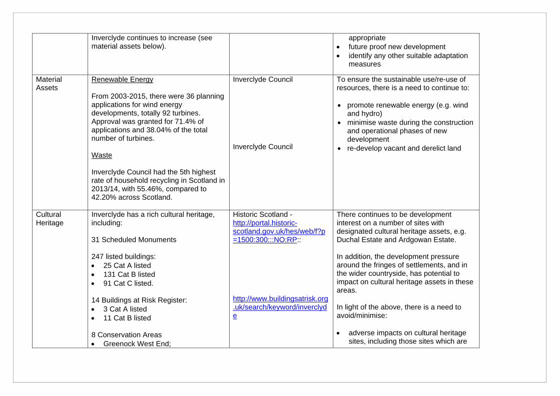
Inverclyde continues to increase (see material assets below).
appropriate future proof new development identify any other suitable adaptation
measures
Material Assets
Renewable Energy From 2003-2015, there were 36 planning applications for wind energy developments, totally 92 turbines. Approval was granted for 71.4% of applications and 38.04% of the total number of turbines. Waste Inverclyde Council had the 5th highest rate of household recycling in Scotland in 2013/14, with 55.46%, compared to 42.20% across Scotland.
Inverclyde Council Inverclyde Council
To ensure the sustainable use/re-use of resources, there is a need to continue to: promote renewable energy (e.g. wind
and hydro) minimise waste during the construction
and operational phases of new development
re-develop vacant and derelict land
Cultural Heritage
Inverclyde has a rich cultural heritage, including: 31 Scheduled Monuments 247 listed buildings: 25 Cat A listed 131 Cat B listed 91 Cat C listed. 14 Buildings at Risk Register: 3 Cat A listed 11 Cat B listed 8 Conservation Areas Greenock West End;
Historic Scotland - http://portal.historic-scotland.gov.uk/hes/web/f?p=1500:300:::NO:RP:: http://www.buildingsatrisk.org.uk/search/keyword/inverclyde
There continues to be development interest on a number of sites with designated cultural heritage assets, e.g. Duchal Estate and Ardgowan Estate. In addition, the development pressure around the fringes of settlements, and in the wider countryside, has potential to impact on cultural heritage assets in these areas. In light of the above, there is a need to avoid/minimise: adverse impacts on cultural heritage
sites, including those sites which are
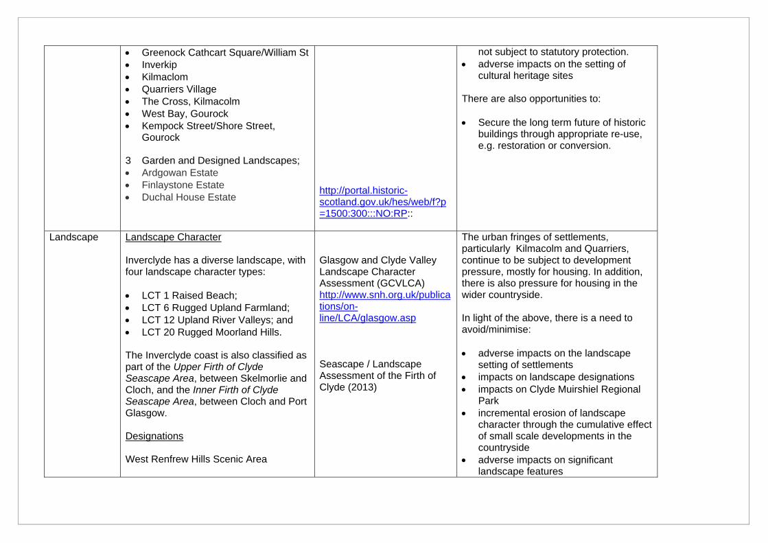
Greenock Cathcart Square/William St Inverkip Kilmaclom Quarriers Village The Cross, Kilmacolm West Bay, Gourock Kempock Street/Shore Street,
Gourock 3 Garden and Designed Landscapes; Ardgowan Estate Finlaystone Estate Duchal House Estate
http://portal.historic-scotland.gov.uk/hes/web/f?p=1500:300:::NO:RP::
not subject to statutory protection. adverse impacts on the setting of
cultural heritage sites There are also opportunities to: Secure the long term future of historic
buildings through appropriate re-use, e.g. restoration or conversion.
Landscape Landscape Character Inverclyde has a diverse landscape, with four landscape character types: LCT 1 Raised Beach; LCT 6 Rugged Upland Farmland; LCT 12 Upland River Valleys; and LCT 20 Rugged Moorland Hills. The Inverclyde coast is also classified as part of the Upper Firth of Clyde Seascape Area, between Skelmorlie and Cloch, and the Inner Firth of Clyde Seascape Area, between Cloch and Port Glasgow. Designations West Renfrew Hills Scenic Area
Glasgow and Clyde Valley Landscape Character Assessment (GCVLCA) http://www.snh.org.uk/publications/on-line/LCA/glasgow.asp Seascape / Landscape Assessment of the Firth of Clyde (2013)
The urban fringes of settlements, particularly Kilmacolm and Quarriers, continue to be subject to development pressure, mostly for housing. In addition, there is also pressure for housing in the wider countryside. In light of the above, there is a need to avoid/minimise: adverse impacts on the landscape
setting of settlements impacts on landscape designations impacts on Clyde Muirshiel Regional
Park incremental erosion of landscape
character through the cumulative effect of small scale developments in the countryside
adverse impacts on significant landscape features
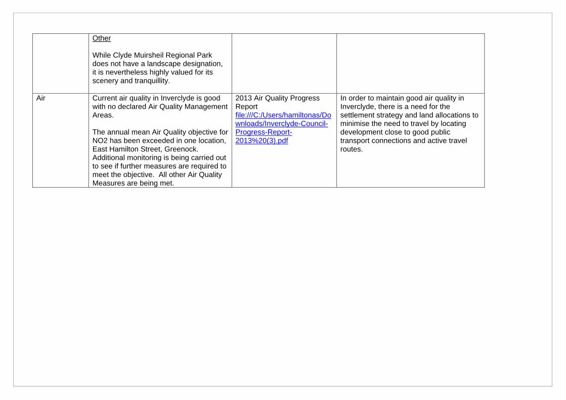
Other While Clyde Muirsheil Regional Park does not have a landscape designation, it is nevertheless highly valued for its scenery and tranquillity.
Air Current air quality in Inverclyde is good with no declared Air Quality Management Areas. The annual mean Air Quality objective for NO2 has been exceeded in one location, East Hamilton Street, Greenock. Additional monitoring is being carried out to see if further measures are required to meet the objective. All other Air Quality Measures are being met.
2013 Air Quality Progress Report file:///C:/Users/hamiltonas/Downloads/Inverclyde-Council-Progress-Report-2013%20(3).pdf
In order to maintain good air quality in Inverclyde, there is a need for the settlement strategy and land allocations to minimise the need to travel by locating development close to good public transport connections and active travel routes.
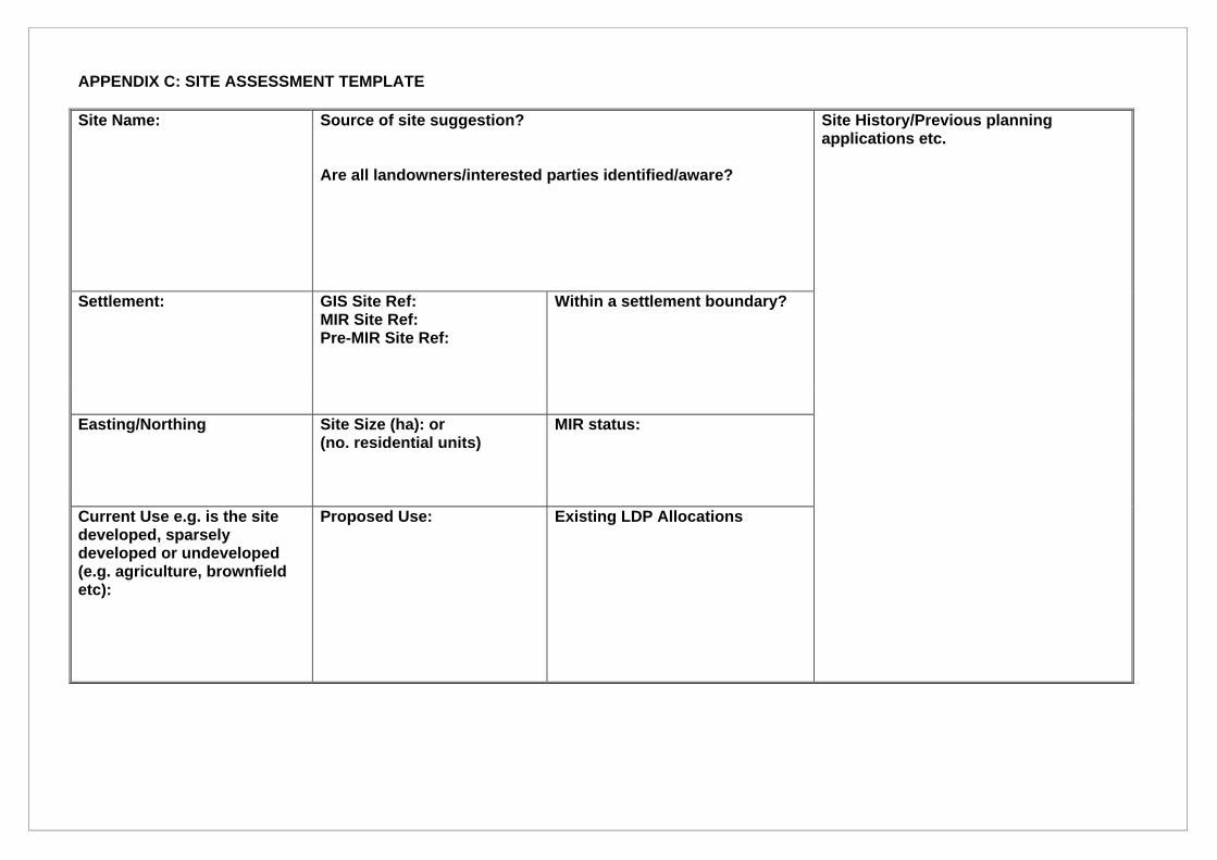
APPENDIX C: SITE ASSESSMENT TEMPLATE Site Name:
Source of site suggestion? Are all landowners/interested parties identified/aware?
Site History/Previous planning applications etc.
Settlement:
GIS Site Ref: MIR Site Ref: Pre-MIR Site Ref:
Within a settlement boundary?
Easting/Northing
Site Size (ha): or (no. residential units)
MIR status:
Current Use e.g. is the site developed, sparsely developed or undeveloped (e.g. agriculture, brownfield etc):
Proposed Use:
Existing LDP Allocations
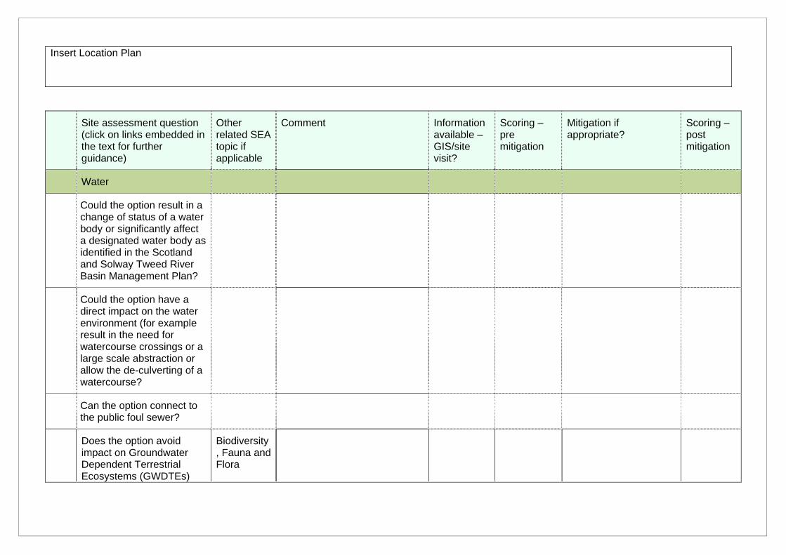
Insert Location Plan
Site assessment question (click on links embedded in the text for further guidance)
Other related SEA topic if applicable
Comment Information available – GIS/site visit?
Scoring – pre mitigation
Mitigation if appropriate?
Scoring – post mitigation
Water
Could the option result in a change of status of a water body or significantly affect a designated water body as identified in the Scotland and Solway Tweed River Basin Management Plan?
Could the option have a direct impact on the water environment (for example result in the need for watercourse crossings or a large scale abstraction or allow the de-culverting of a watercourse?
Can the option connect to the public foul sewer?
Does the option avoid impact on Groundwater Dependent Terrestrial Ecosystems (GWDTEs)
Biodiversity, Fauna and Flora
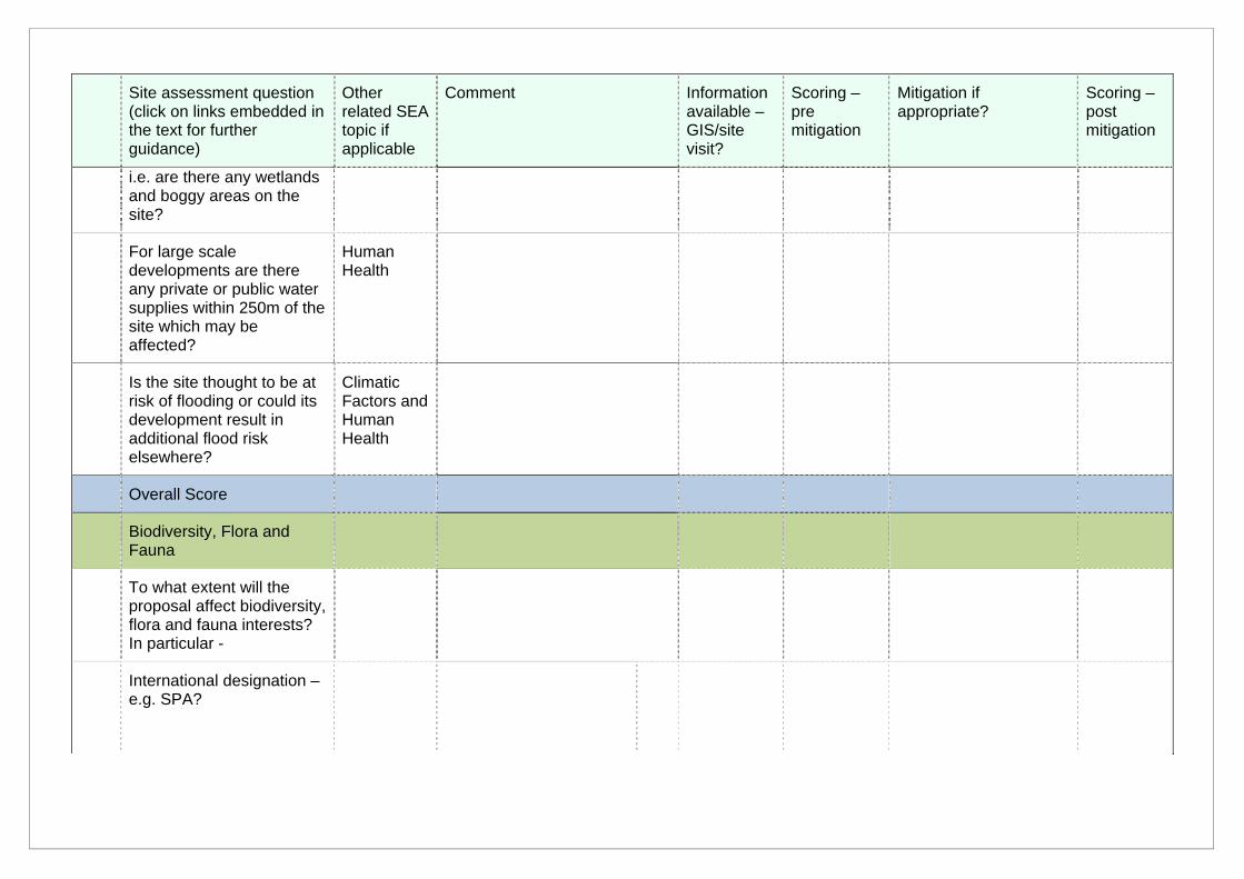
Site assessment question (click on links embedded in the text for further guidance)
Other related SEA topic if applicable
Comment Information available – GIS/site visit?
Scoring – pre mitigation
Mitigation if appropriate?
Scoring – post mitigation
i.e. are there any wetlands and boggy areas on the site?
For large scale developments are there any private or public water supplies within 250m of the site which may be affected?
Human Health
Is the site thought to be at risk of flooding or could its development result in additional flood risk elsewhere?
Climatic Factors and Human Health
Overall Score
Biodiversity, Flora and Fauna
To what extent will the proposal affect biodiversity, flora and fauna interests? In particular -
International designation – e.g. SPA?
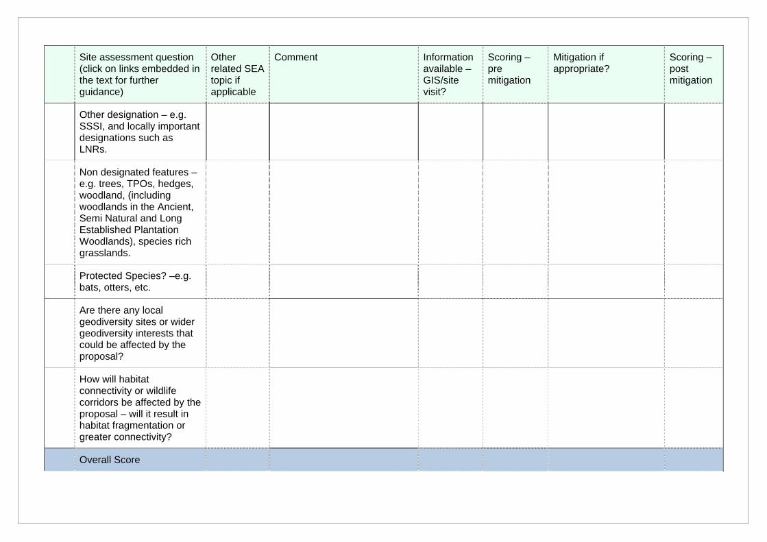
Site assessment question (click on links embedded in the text for further guidance)
Other related SEA topic if applicable
Comment Information available – GIS/site visit?
Scoring – pre mitigation
Mitigation if appropriate?
Scoring – post mitigation
Other designation – e.g. SSSI, and locally important designations such as LNRs.
Non designated features – e.g. trees, TPOs, hedges, woodland, (including woodlands in the Ancient, Semi Natural and Long Established Plantation Woodlands), species rich grasslands.
Protected Species? –e.g. bats, otters, etc.
Are there any local geodiversity sites or wider geodiversity interests that could be affected by the proposal?
How will habitat connectivity or wildlife corridors be affected by the proposal – will it result in habitat fragmentation or greater connectivity?
Overall Score
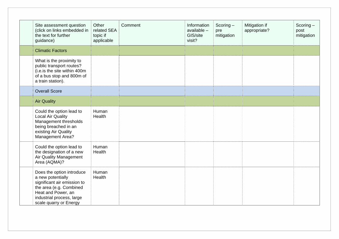
Site assessment question (click on links embedded in the text for further guidance)
Other related SEA topic if applicable
Comment Information available – GIS/site visit?
Scoring – pre mitigation
Mitigation if appropriate?
Scoring – post mitigation
Climatic Factors
What is the proximity to public transport routes? (i.e.is the site within 400m of a bus stop and 800m of a train station).
Overall Score
Air Quality
Could the option lead to Local Air Quality Management thresholds being breached in an existing Air Quality Management Area?
Human Health
Could the option lead to the designation of a new Air Quality Management Area (AQMA)?
Human Health
Does the option introduce a new potentially significant air emission to the area (e.g. Combined Heat and Power, an industrial process, large scale quarry or Energy
Human Health
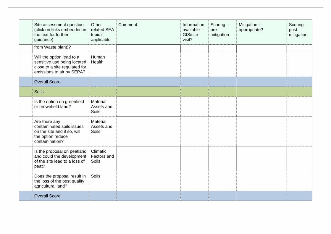
Site assessment question (click on links embedded in the text for further guidance)
Other related SEA topic if applicable
Comment Information available – GIS/site visit?
Scoring – pre mitigation
Mitigation if appropriate?
Scoring – post mitigation
from Waste plant)?
Will the option lead to a sensitive use being located close to a site regulated for emissions to air by SEPA?
Human Health
Overall Score
Soils
Is the option on greenfield or brownfield land?
Material Assets and Soils
Are there any contaminated soils issues on the site and if so, will the option reduce contamination?
Material Assets and Soils
Is the proposal on peatland and could the development of the site lead to a loss of peat?
Climatic Factors and Soils
Does the proposal result in the loss of the best quality agricultural land?
Soils
Overall Score
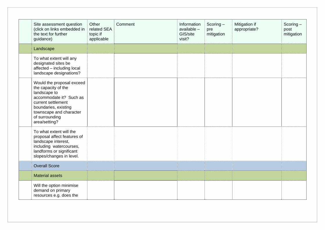
Site assessment question (click on links embedded in the text for further guidance)
Other related SEA topic if applicable
Comment Information available – GIS/site visit?
Scoring – pre mitigation
Mitigation if appropriate?
Scoring – post mitigation
Landscape
To what extent will any designated sites be affected – including local landscape designations?
Would the proposal exceed the capacity of the landscape to accommodate it? Such as current settlement boundaries, existing townscape and character of surrounding area/setting?
To what extent will the proposal affect features of landscape interest, including watercourses, landforms or significant slopes/changes in level.
Overall Score
Material assets
Will the option minimise demand on primary resources e.g. does the
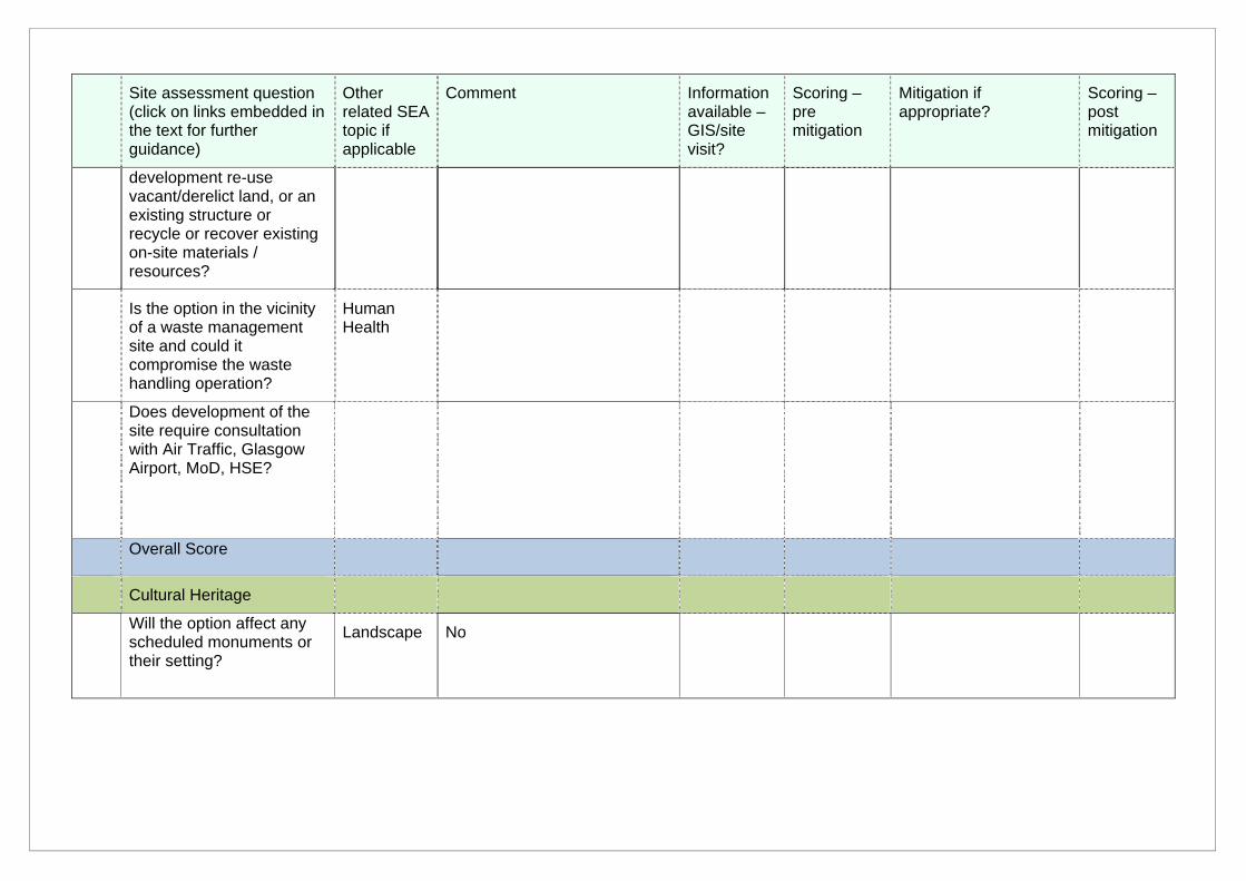
Site assessment question (click on links embedded in the text for further guidance)
Other related SEA topic if applicable
Comment Information available – GIS/site visit?
Scoring – pre mitigation
Mitigation if appropriate?
Scoring – post mitigation
development re-use vacant/derelict land, or an existing structure or recycle or recover existing on-site materials / resources?
Is the option in the vicinity of a waste management site and could it compromise the waste handling operation?
Human Health
Does development of the site require consultation with Air Traffic, Glasgow Airport, MoD, HSE?
Overall Score
Cultural Heritage
Will the option affect any scheduled monuments or their setting?
Landscape No
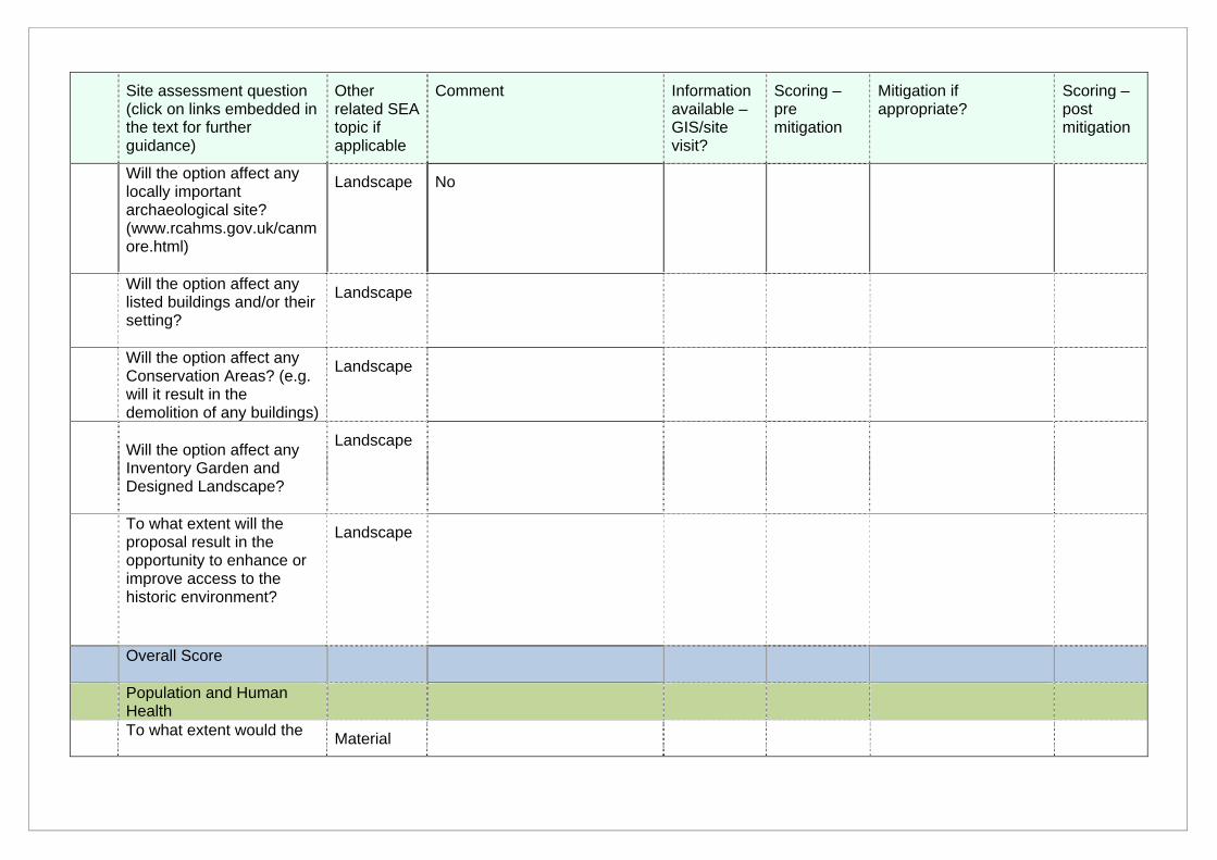
Site assessment question (click on links embedded in the text for further guidance)
Other related SEA topic if applicable
Comment Information available – GIS/site visit?
Scoring – pre mitigation
Mitigation if appropriate?
Scoring – post mitigation
Will the option affect any locally important archaeological site? (www.rcahms.gov.uk/canmore.html)
Landscape No
Will the option affect any listed buildings and/or their setting?
Landscape
Will the option affect any Conservation Areas? (e.g. will it result in the demolition of any buildings)
Landscape
Will the option affect any Inventory Garden and Designed Landscape?
Landscape
To what extent will the proposal result in the opportunity to enhance or improve access to the historic environment?
Landscape
Overall Score
Population and Human Health
To what extent would the Material
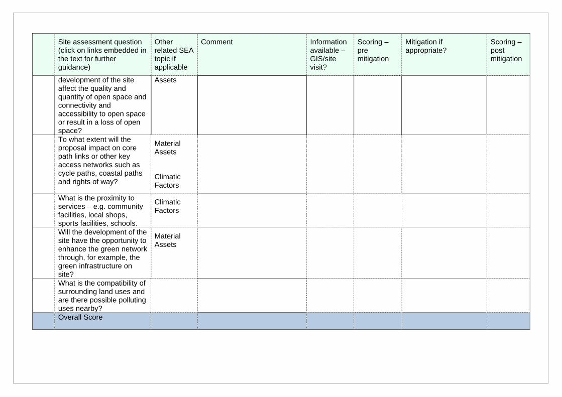
Site assessment question (click on links embedded in the text for further guidance)
Other related SEA topic if applicable
Comment Information available – GIS/site visit?
Scoring – pre mitigation
Mitigation if appropriate?
Scoring – post mitigation
development of the site affect the quality and quantity of open space and connectivity and accessibility to open space or result in a loss of open space?
Assets
To what extent will the proposal impact on core path links or other key access networks such as cycle paths, coastal paths and rights of way?
Material Assets
Climatic Factors
What is the proximity to services – e.g. community facilities, local shops, sports facilities, schools.
Climatic Factors
Will the development of the site have the opportunity to enhance the green network through, for example, the green infrastructure on site?
Material Assets
What is the compatibility of surrounding land uses and are there possible polluting uses nearby?
Overall Score
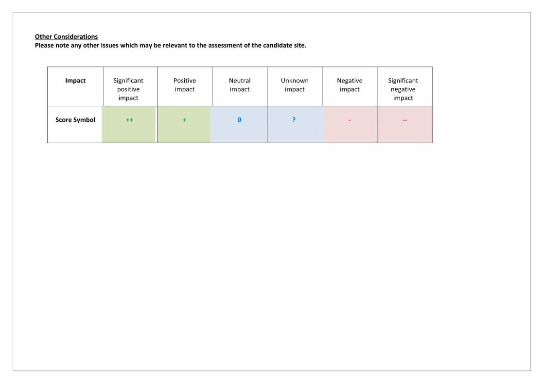
Other Considerations Please note any other issues which may be relevant to the assessment of the candidate site.
Impact
Significant positive impact
Positive impact
Neutral impact
Unknown impact
Negative impact
Significant negative impact
Score Symbol
++
+
0
?
‐
‐‐
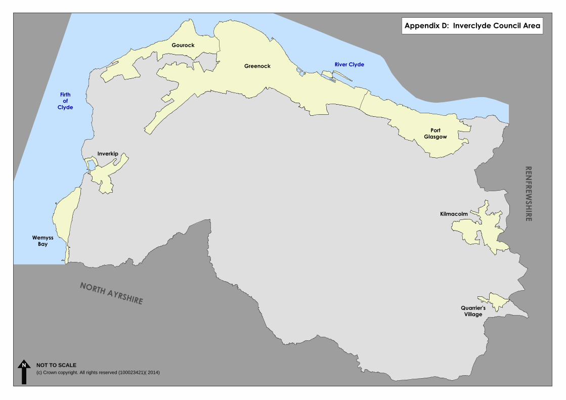
NOT TO SCALE(c) Crown copyright. All rights reserved (100023421)( 2014)
Appendix D: Inverclyde Council AreaREN
FREWSHIRE
NORTH AYRSHIRE
River Clyde
Firthof
Clyde
Inverkip
PortGlasgow
Greenock
Gourock
Kilmacolm
Quarrier'sVillage
WemyssBay
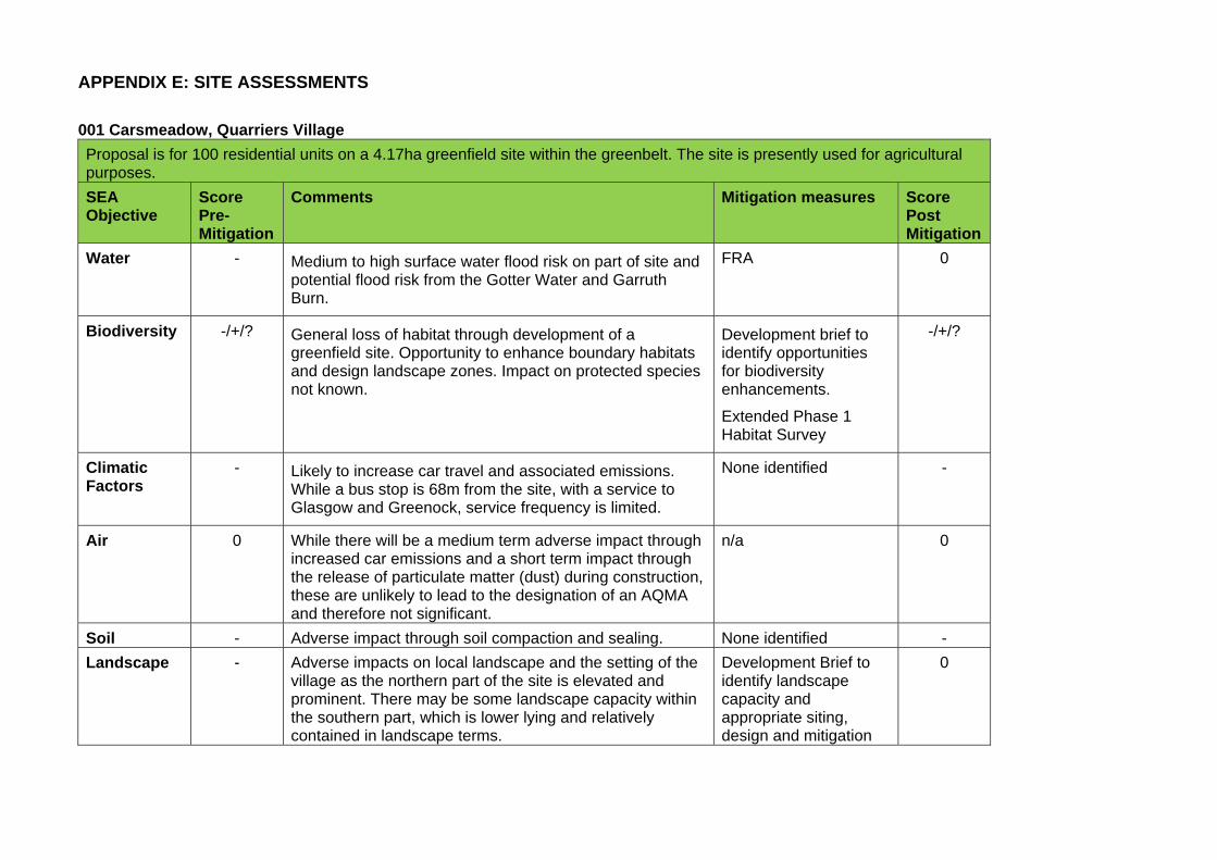
APPENDIX E: SITE ASSESSMENTS
001 Carsmeadow, Quarriers Village
Proposal is for 100 residential units on a 4.17ha greenfield site within the greenbelt. The site is presently used for agricultural purposes.
SEA Objective
Score Pre-Mitigation
Comments Mitigation measures Score Post Mitigation
Water - Medium to high surface water flood risk on part of site and potential flood risk from the Gotter Water and Garruth Burn.
FRA 0
Biodiversity -/+/? General loss of habitat through development of a greenfield site. Opportunity to enhance boundary habitats and design landscape zones. Impact on protected species not known.
Development brief to identify opportunities for biodiversity enhancements.
Extended Phase 1 Habitat Survey
-/+/?
Climatic Factors
- Likely to increase car travel and associated emissions. While a bus stop is 68m from the site, with a service to Glasgow and Greenock, service frequency is limited.
None identified -
Air 0 While there will be a medium term adverse impact through increased car emissions and a short term impact through the release of particulate matter (dust) during construction, these are unlikely to lead to the designation of an AQMA and therefore not significant.
n/a 0
Soil - Adverse impact through soil compaction and sealing. None identified -
Landscape - Adverse impacts on local landscape and the setting of the village as the northern part of the site is elevated and prominent. There may be some landscape capacity within the southern part, which is lower lying and relatively contained in landscape terms.
Development Brief to identify landscape capacity and appropriate siting, design and mitigation
0
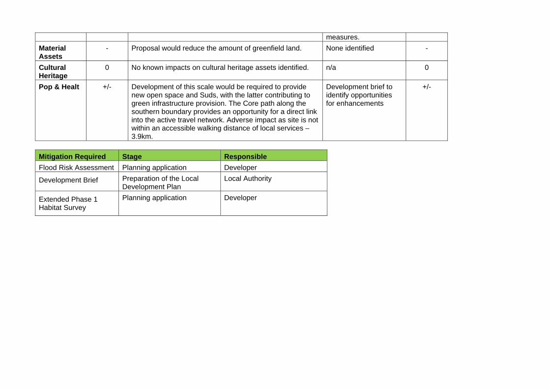
measures.
Material Assets
- Proposal would reduce the amount of greenfield land. None identified -
Cultural Heritage
0 No known impacts on cultural heritage assets identified. n/a 0
Pop & Healt +/- Development of this scale would be required to provide new open space and Suds, with the latter contributing to green infrastructure provision. The Core path along the southern boundary provides an opportunity for a direct link into the active travel network. Adverse impact as site is not within an accessible walking distance of local services – 3.9km.
Development brief to identify opportunities for enhancements
+/-
Mitigation Required Stage Responsible
Flood Risk Assessment Planning application Developer
Development Brief Preparation of the Local Development Plan
Local Authority
Extended Phase 1 Habitat Survey
Planning application Developer
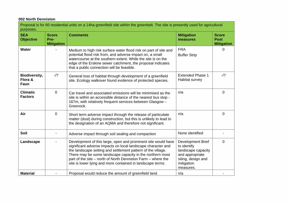
002 North Denniston
Proposal is for 60 residential units on a 14ha greenfield site within the greenbelt. The site is presently used for agricultural purposes.
SEA Objective
Score Pre-Mitigation
Comments Mitigation measures
Score Post Mitigation
Water - Medium to high risk surface water flood risk on part of site and potential flood risk from, and adverse impact on, a small watercourse at the southern extent. While the site is on the edge of the Erskine sewer catchment, the proposal indicates that a public connection will be feasible.
FRA
Buffer Strip
0
Biodiversity, Flora & Faun
-/? General loss of habitat through development of a greenfield site. Ecology walkover found evidence of protected species.
Extended Phase 1 Habitat survey
-/?
Climatic Factors
0 Car travel and associated emissions will be minimised as the site is within an accessible distance of the nearest bus stop - 167m, with relatively frequent services between Glasgow – Greenock.
n/a 0
Air 0 Short term adverse impact through the release of particulate matter (dust) during construction, but this is unlikely to lead to the designation of an AQMA and therefore not significant.
n/a 0
Soil - Adverse impact through soil sealing and compaction None identified -
Landscape - Development of this large, open and prominent site would have significant adverse impacts on local landscape character and the landscape setting and settlement pattern of the village. There may be some landscape capacity in the northern most part of the site – north of North Denniston Farm – where the site is lower lying and more contained in landscape terms.
Development Brief to identify landscape capacity and appropriate siting, design and mitigation measures.
0
Material - Proposal would reduce the amount of greenfield land. n/a -
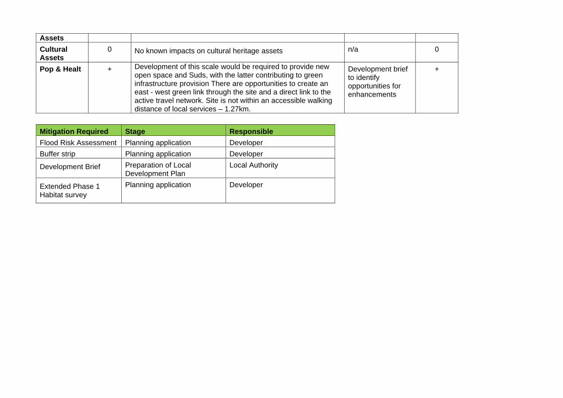
Assets
Cultural Assets
0 No known impacts on cultural heritage assets n/a 0
Pop & Healt + Development of this scale would be required to provide new open space and Suds, with the latter contributing to green infrastructure provision There are opportunities to create an east - west green link through the site and a direct link to the active travel network. Site is not within an accessible walking distance of local services – 1.27km.
Development brief to identify opportunities for enhancements
+
Mitigation Required Stage Responsible
Flood Risk Assessment Planning application Developer
Buffer strip Planning application Developer
Development Brief Preparation of Local Development Plan
Local Authority
Extended Phase 1 Habitat survey
Planning application Developer
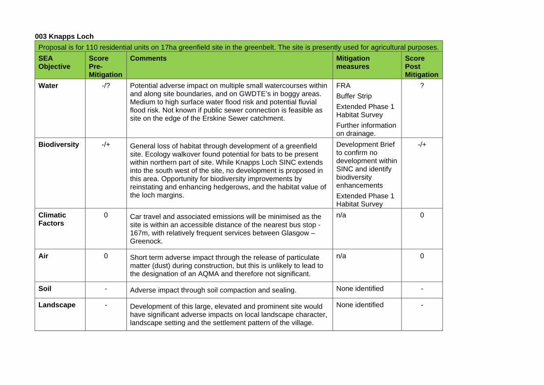
003 Knapps Loch
Proposal is for 110 residential units on 17ha greenfield site in the greenbelt. The site is presently used for agricultural purposes.
SEA Objective
Score Pre-Mitigation
Comments Mitigation measures
Score Post Mitigation
Water -/? Potential adverse impact on multiple small watercourses within and along site boundaries, and on GWDTE’s in boggy areas. Medium to high surface water flood risk and potential fluvial flood risk. Not known if public sewer connection is feasible as site on the edge of the Erskine Sewer catchment.
FRA
Buffer Strip
Extended Phase 1 Habitat Survey
Further information on drainage.
?
Biodiversity -/+ General loss of habitat through development of a greenfield site. Ecology walkover found potential for bats to be present within northern part of site. While Knapps Loch SINC extends into the south west of the site, no development is proposed in this area. Opportunity for biodiversity improvements by reinstating and enhancing hedgerows, and the habitat value of the loch margins.
Development Brief to confirm no development within SINC and identify biodiversity enhancements
Extended Phase 1 Habitat Survey
-/+
Climatic Factors
0 Car travel and associated emissions will be minimised as the site is within an accessible distance of the nearest bus stop - 167m, with relatively frequent services between Glasgow – Greenock.
n/a 0
Air 0 Short term adverse impact through the release of particulate matter (dust) during construction, but this is unlikely to lead to the designation of an AQMA and therefore not significant.
n/a 0
Soil - Adverse impact through soil compaction and sealing. None identified -
Landscape - Development of this large, elevated and prominent site would have significant adverse impacts on local landscape character, landscape setting and the settlement pattern of the village.
None identified -
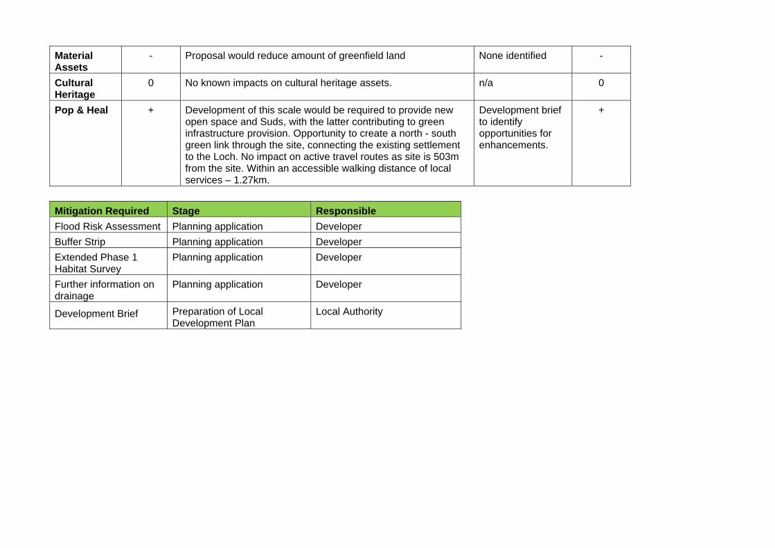
Material Assets
- Proposal would reduce amount of greenfield land None identified -
Cultural Heritage
0 No known impacts on cultural heritage assets. n/a 0
Pop & Heal + Development of this scale would be required to provide new open space and Suds, with the latter contributing to green infrastructure provision. Opportunity to create a north - south green link through the site, connecting the existing settlement to the Loch. No impact on active travel routes as site is 503m from the site. Within an accessible walking distance of local services – 1.27km.
Development brief to identify opportunities for enhancements.
+
Mitigation Required Stage Responsible
Flood Risk Assessment Planning application Developer
Buffer Strip Planning application Developer
Extended Phase 1 Habitat Survey
Planning application Developer
Further information on drainage
Planning application Developer
Development Brief Preparation of Local Development Plan
Local Authority
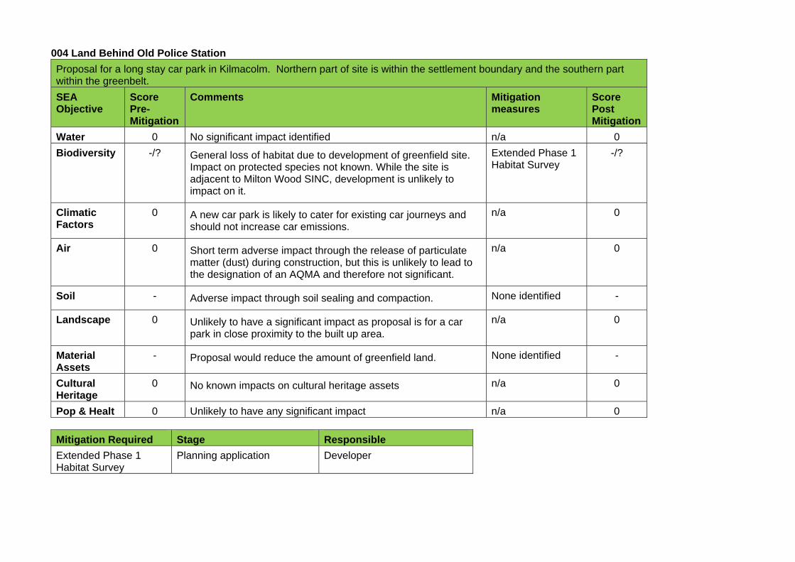
004 Land Behind Old Police Station
Proposal for a long stay car park in Kilmacolm. Northern part of site is within the settlement boundary and the southern part within the greenbelt.
SEA Objective
Score Pre-Mitigation
Comments Mitigation measures
Score Post Mitigation
Water 0 No significant impact identified n/a 0
Biodiversity -/? General loss of habitat due to development of greenfield site. Impact on protected species not known. While the site is adjacent to Milton Wood SINC, development is unlikely to impact on it.
Extended Phase 1 Habitat Survey
-/?
Climatic Factors
0 A new car park is likely to cater for existing car journeys and should not increase car emissions.
n/a 0
Air 0 Short term adverse impact through the release of particulate matter (dust) during construction, but this is unlikely to lead to the designation of an AQMA and therefore not significant.
n/a 0
Soil - Adverse impact through soil sealing and compaction. None identified -
Landscape 0 Unlikely to have a significant impact as proposal is for a car park in close proximity to the built up area.
n/a 0
Material Assets
- Proposal would reduce the amount of greenfield land. None identified -
Cultural Heritage
0 No known impacts on cultural heritage assets n/a 0
Pop & Healt 0 Unlikely to have any significant impact n/a 0
Mitigation Required Stage Responsible
Extended Phase 1 Habitat Survey
Planning application Developer
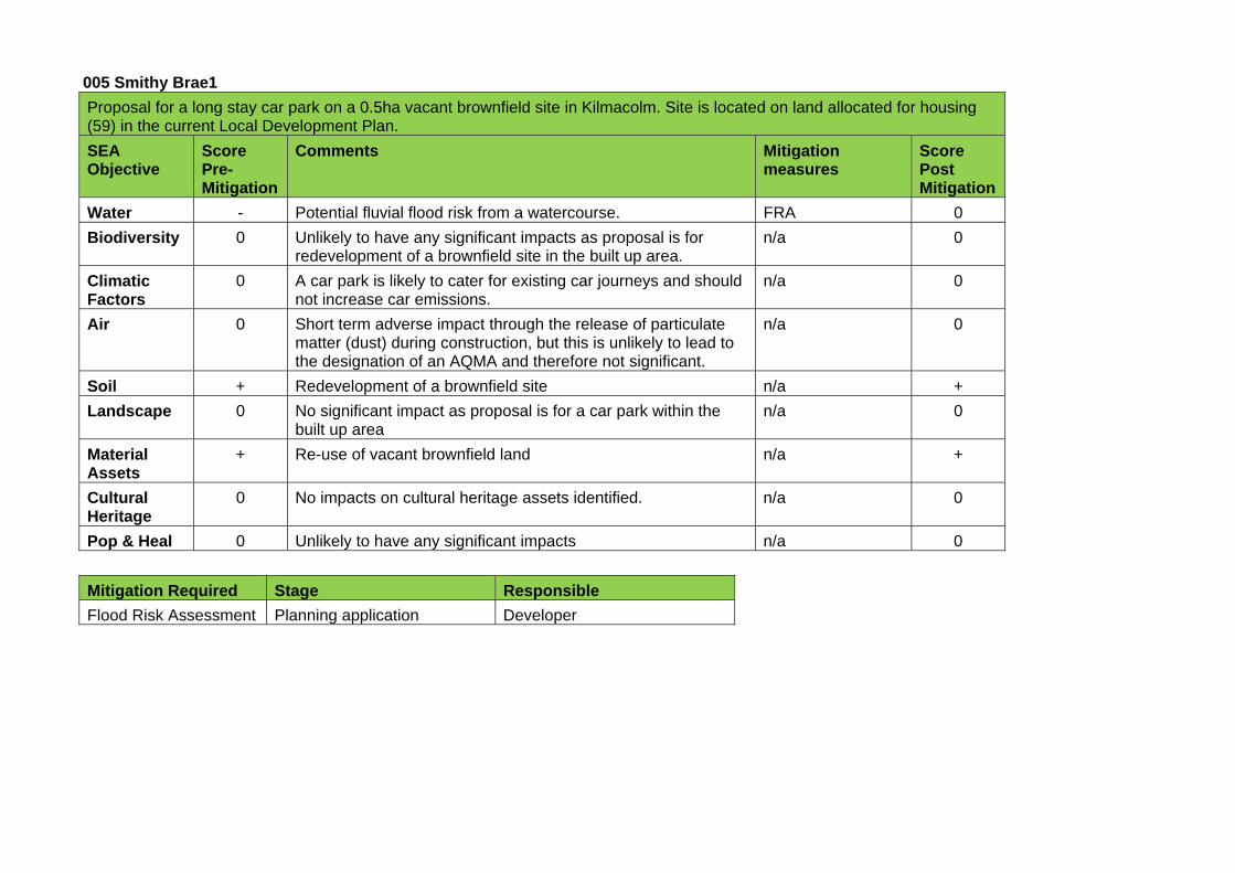
005 Smithy Brae1 Proposal for a long stay car park on a 0.5ha vacant brownfield site in Kilmacolm. Site is located on land allocated for housing (59) in the current Local Development Plan.
SEA Objective
Score Pre-Mitigation
Comments Mitigation measures
Score Post Mitigation
Water - Potential fluvial flood risk from a watercourse. FRA 0
Biodiversity 0 Unlikely to have any significant impacts as proposal is for redevelopment of a brownfield site in the built up area.
n/a 0
Climatic Factors
0 A car park is likely to cater for existing car journeys and should not increase car emissions.
n/a 0
Air 0 Short term adverse impact through the release of particulate matter (dust) during construction, but this is unlikely to lead to the designation of an AQMA and therefore not significant.
n/a 0
Soil + Redevelopment of a brownfield site n/a +
Landscape 0 No significant impact as proposal is for a car park within the built up area
n/a 0
Material Assets
+ Re-use of vacant brownfield land n/a +
Cultural Heritage
0 No impacts on cultural heritage assets identified. n/a 0
Pop & Heal 0 Unlikely to have any significant impacts n/a 0
Mitigation Required Stage Responsible
Flood Risk Assessment Planning application Developer

006 Smithy Brae2
Proposal for a long stay car park on a 0.06ha greenfield site in Kilmacolm.
SEA Objective
Score Pre-Mitigation
Comments Mitigation measures
Score Post Mitigation
Water - Potential adverse impact on watercourse along site boundary. Medium to high surface water flood risk and fluvial flood risk adjacent to site.
Buffer Strip
FRA
0
Biodiversity - Minor loss of habitat through development of a greenfield site. None identified -
Climatic Factors
0 A car park is likely to cater for existing car journeys and should not increase transport emissions.
n/a 0
Air 0 Short term adverse impact through the release of particulate matter (dust) during construction, but this is unlikely to lead to the designation of an AQMA and therefore not significant.
n/a 0
Soil - Minor adverse impact through soil sealing and compaction None identified -
Landscape 0 Unlikely to have any significant impacts as site is within the built up area
n/a 0
Material Assets
- Minor reduction in the amount of greenfield land. None identified -
Cultural Heritage
0 No known impact on cultural assets
Pop & Heal 0 Unlikely to have any significant impacts n/a 0
Mitigation Required Stage Responsible
Flood Risk Assessment Planning application Developer
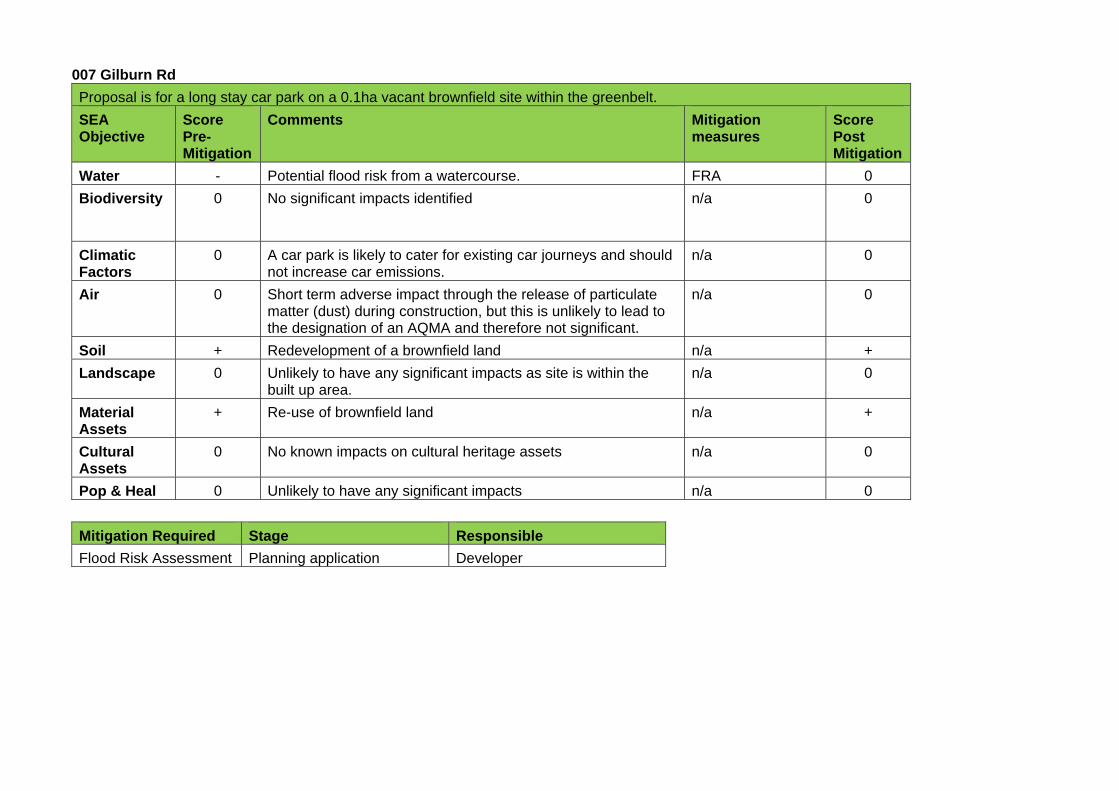
007 Gilburn Rd
Proposal is for a long stay car park on a 0.1ha vacant brownfield site within the greenbelt.
SEA Objective
Score Pre-Mitigation
Comments Mitigation measures
Score Post Mitigation
Water - Potential flood risk from a watercourse. FRA 0
Biodiversity 0 No significant impacts identified n/a 0
Climatic Factors
0 A car park is likely to cater for existing car journeys and should not increase car emissions.
n/a 0
Air 0 Short term adverse impact through the release of particulate matter (dust) during construction, but this is unlikely to lead to the designation of an AQMA and therefore not significant.
n/a 0
Soil + Redevelopment of a brownfield land n/a +
Landscape 0 Unlikely to have any significant impacts as site is within the built up area.
n/a 0
Material Assets
+ Re-use of brownfield land n/a +
Cultural Assets
0 No known impacts on cultural heritage assets n/a 0
Pop & Heal 0 Unlikely to have any significant impacts n/a 0
Mitigation Required Stage Responsible
Flood Risk Assessment Planning application Developer
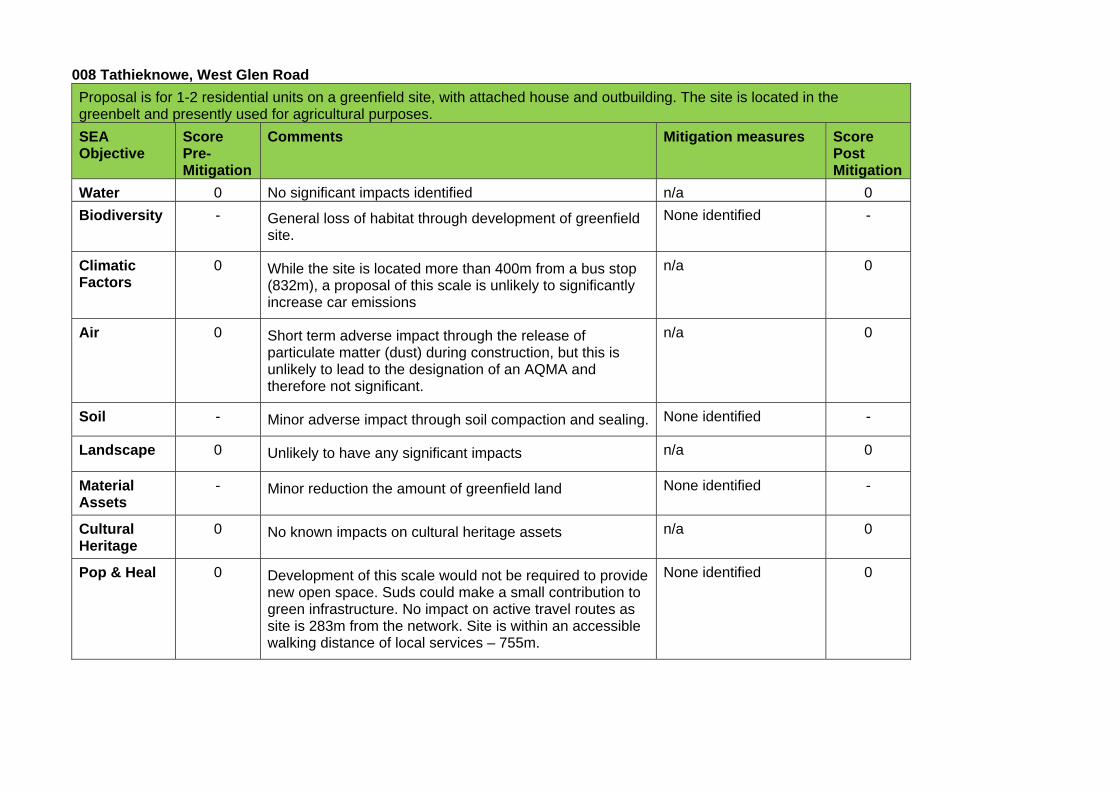
008 Tathieknowe, West Glen Road
Proposal is for 1-2 residential units on a greenfield site, with attached house and outbuilding. The site is located in the greenbelt and presently used for agricultural purposes.
SEA Objective
Score Pre-Mitigation
Comments Mitigation measures Score Post Mitigation
Water 0 No significant impacts identified n/a 0
Biodiversity - General loss of habitat through development of greenfield site.
None identified -
Climatic Factors
0 While the site is located more than 400m from a bus stop (832m), a proposal of this scale is unlikely to significantly increase car emissions
n/a 0
Air 0 Short term adverse impact through the release of particulate matter (dust) during construction, but this is unlikely to lead to the designation of an AQMA and therefore not significant.
n/a 0
Soil - Minor adverse impact through soil compaction and sealing. None identified -
Landscape 0 Unlikely to have any significant impacts n/a 0
Material Assets
- Minor reduction the amount of greenfield land None identified -
Cultural Heritage
0 No known impacts on cultural heritage assets n/a 0
Pop & Heal 0 Development of this scale would not be required to provide new open space. Suds could make a small contribution to green infrastructure. No impact on active travel routes as site is 283m from the network. Site is within an accessible walking distance of local services – 755m.
None identified 0
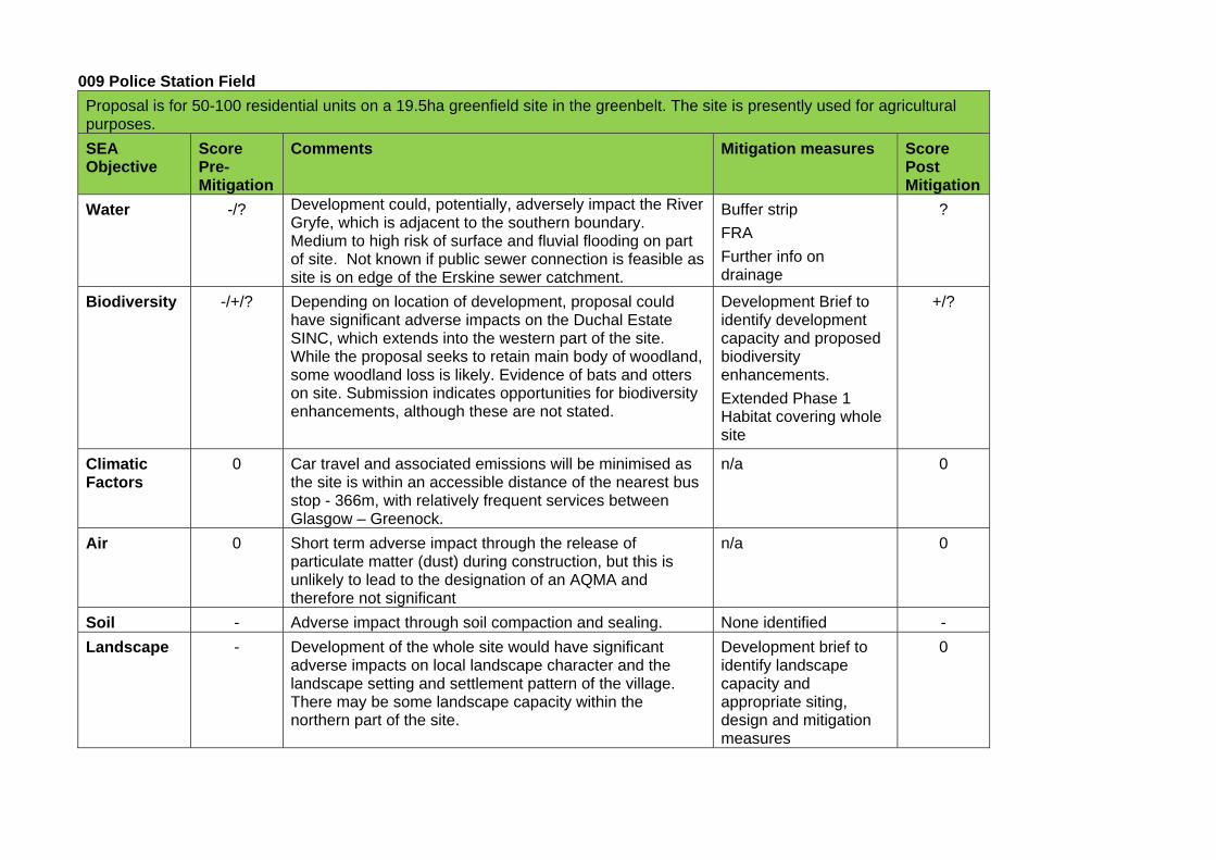
009 Police Station Field
Proposal is for 50-100 residential units on a 19.5ha greenfield site in the greenbelt. The site is presently used for agricultural purposes.
SEA Objective
Score Pre-Mitigation
Comments Mitigation measures Score Post Mitigation
Water -/? Development could, potentially, adversely impact the River Gryfe, which is adjacent to the southern boundary. Medium to high risk of surface and fluvial flooding on part of site. Not known if public sewer connection is feasible as site is on edge of the Erskine sewer catchment.
Buffer strip
FRA
Further info on drainage
?
Biodiversity -/+/? Depending on location of development, proposal could have significant adverse impacts on the Duchal Estate SINC, which extends into the western part of the site. While the proposal seeks to retain main body of woodland, some woodland loss is likely. Evidence of bats and otters on site. Submission indicates opportunities for biodiversity enhancements, although these are not stated.
Development Brief to identify development capacity and proposed biodiversity enhancements.
Extended Phase 1 Habitat covering whole site
+/?
Climatic Factors
0 Car travel and associated emissions will be minimised as the site is within an accessible distance of the nearest bus stop - 366m, with relatively frequent services between Glasgow – Greenock.
n/a 0
Air 0 Short term adverse impact through the release of particulate matter (dust) during construction, but this is unlikely to lead to the designation of an AQMA and therefore not significant
n/a 0
Soil - Adverse impact through soil compaction and sealing. None identified -
Landscape - Development of the whole site would have significant adverse impacts on local landscape character and the landscape setting and settlement pattern of the village. There may be some landscape capacity within the northern part of the site.
Development brief to identify landscape capacity and appropriate siting, design and mitigation measures
0
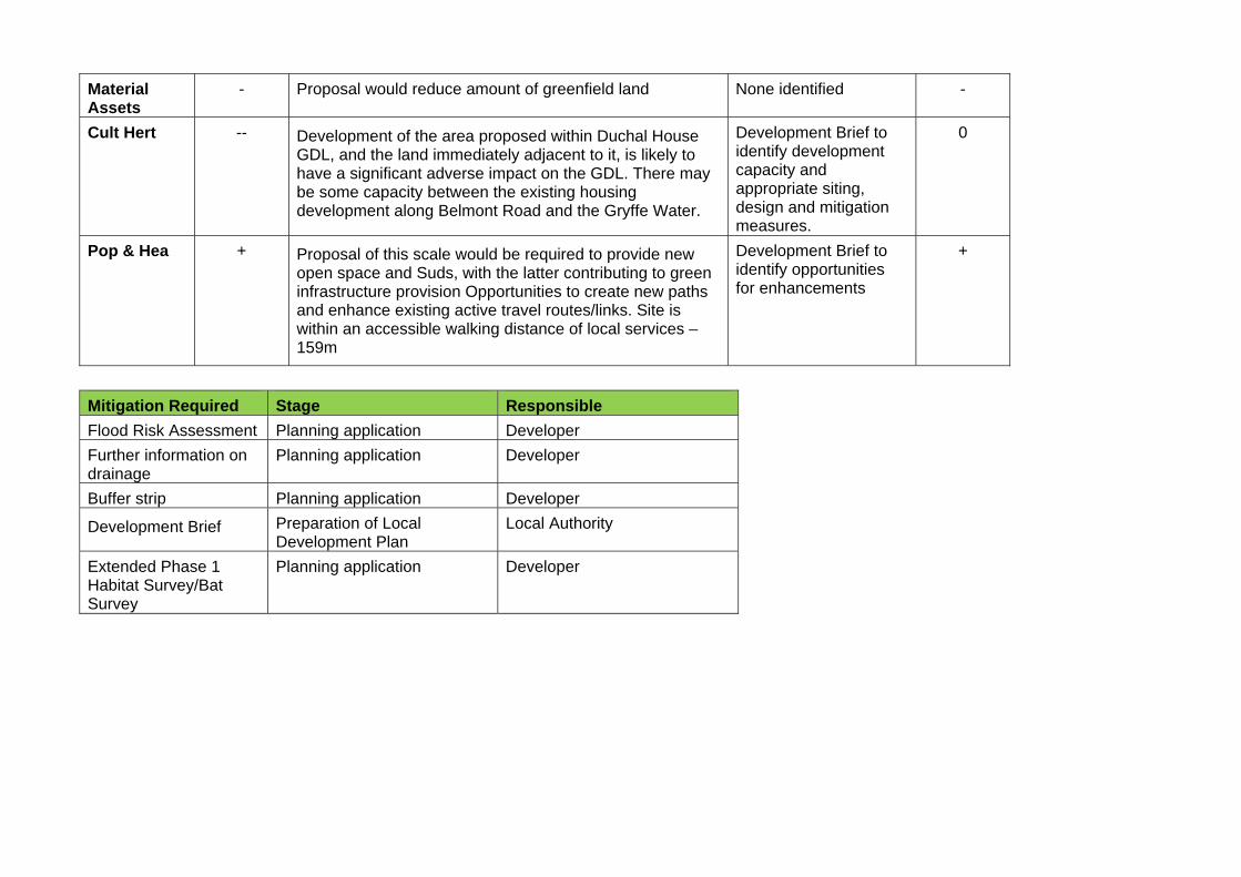
Material Assets
- Proposal would reduce amount of greenfield land None identified -
Cult Hert -- Development of the area proposed within Duchal House GDL, and the land immediately adjacent to it, is likely to have a significant adverse impact on the GDL. There may be some capacity between the existing housing development along Belmont Road and the Gryffe Water.
Development Brief to identify development capacity and appropriate siting, design and mitigation measures.
0
Pop & Hea + Proposal of this scale would be required to provide new open space and Suds, with the latter contributing to green infrastructure provision Opportunities to create new paths and enhance existing active travel routes/links. Site is within an accessible walking distance of local services – 159m
Development Brief to identify opportunities for enhancements
+
Mitigation Required Stage Responsible
Flood Risk Assessment Planning application Developer
Further information on drainage
Planning application Developer
Buffer strip Planning application Developer
Development Brief Preparation of Local Development Plan
Local Authority
Extended Phase 1 Habitat Survey/Bat Survey
Planning application Developer
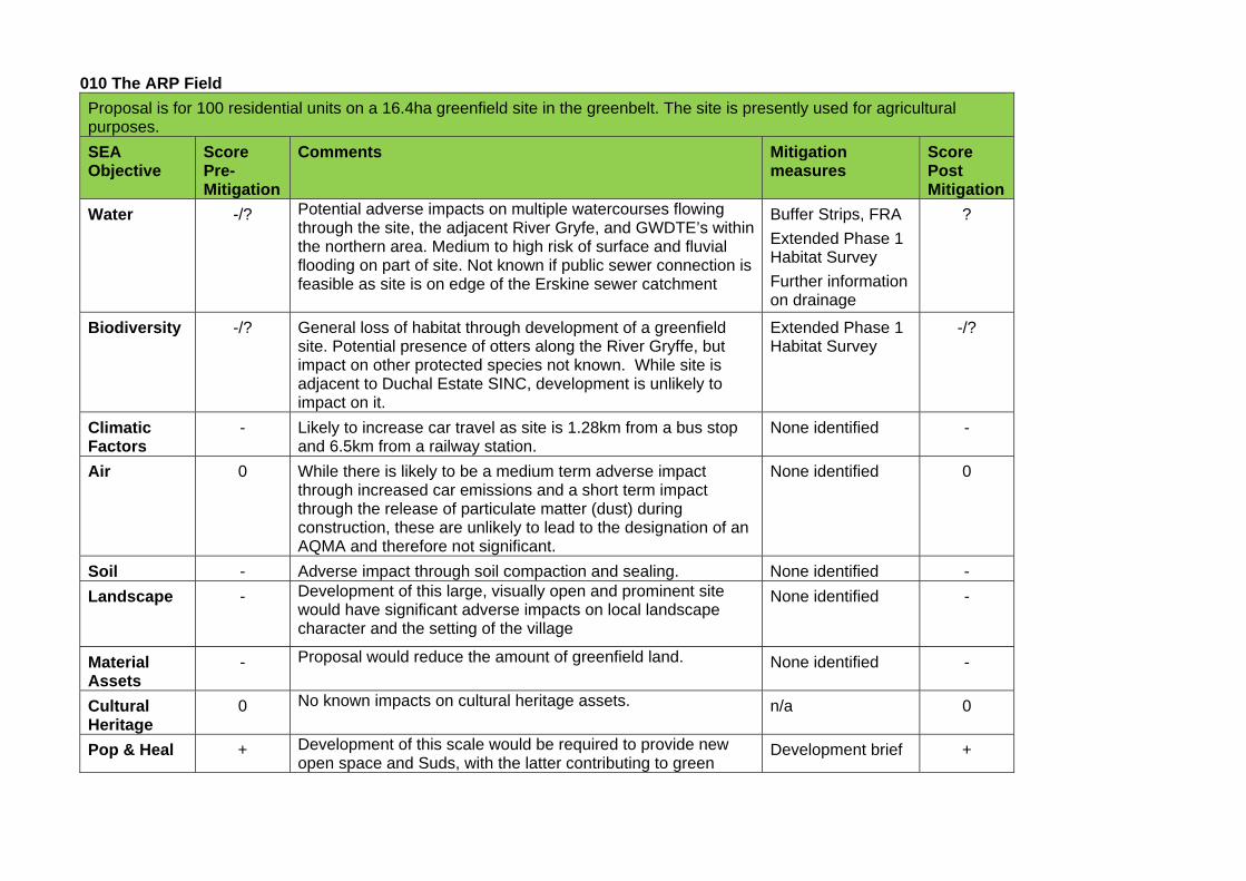
010 The ARP Field
Proposal is for 100 residential units on a 16.4ha greenfield site in the greenbelt. The site is presently used for agricultural purposes.
SEA Objective
Score Pre-Mitigation
Comments Mitigation measures
Score Post Mitigation
Water -/? Potential adverse impacts on multiple watercourses flowing through the site, the adjacent River Gryfe, and GWDTE’s within the northern area. Medium to high risk of surface and fluvial flooding on part of site. Not known if public sewer connection is feasible as site is on edge of the Erskine sewer catchment
Buffer Strips, FRA
Extended Phase 1 Habitat Survey
Further information on drainage
?
Biodiversity -/? General loss of habitat through development of a greenfield site. Potential presence of otters along the River Gryffe, but impact on other protected species not known. While site is adjacent to Duchal Estate SINC, development is unlikely to impact on it.
Extended Phase 1 Habitat Survey
-/?
Climatic Factors
- Likely to increase car travel as site is 1.28km from a bus stop and 6.5km from a railway station.
None identified -
Air 0 While there is likely to be a medium term adverse impact through increased car emissions and a short term impact through the release of particulate matter (dust) during construction, these are unlikely to lead to the designation of an AQMA and therefore not significant.
None identified 0
Soil - Adverse impact through soil compaction and sealing. None identified -
Landscape - Development of this large, visually open and prominent site would have significant adverse impacts on local landscape character and the setting of the village
None identified -
Material Assets
- Proposal would reduce the amount of greenfield land. None identified -
Cultural Heritage
0 No known impacts on cultural heritage assets. n/a 0
Pop & Heal + Development of this scale would be required to provide new open space and Suds, with the latter contributing to green
Development brief +
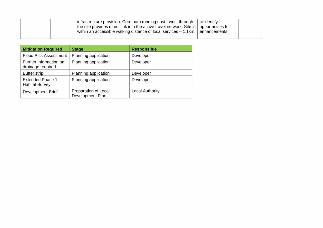
infrastructure provision. Core path running east - west through the site provides direct link into the active travel network. Site is within an accessible walking distance of local services – 1.1km.
to identify opportunities for enhancements.
Mitigation Required Stage Responsible
Flood Risk Assessment Planning application Developer
Further information on drainage required
Planning application Developer
Buffer strip Planning application Developer
Extended Phase 1 Habitat Survey
Planning application Developer
Development Brief Preparation of Local Development Plan
Local Authority

011 West Glen Road
Proposal is for 60 residential units on a 5.65ha greenfield site in the greenbelt. The site is presently used for agricultural purposes.
SEA Objective
Score Pre-Mitigation
Comments Mitigation measures
Score Post Mitigation
Water -/? Potential adverse impact on GWDTE’s within boggy areas. Medium to high surface water flood risk and potential flood risk from adjacent watercourse. Not known if public sewer connection is feasible as site on edge of the Erskine sewer catchment.
FRA
Extended Phase 1 Habitat Survey
?
Biodiversity -/? General loss of habitat through development of a greenfield site. Impact on protected species not known. Further information on hydrology and drainage required to determine impact on the Glen Moss SSSI, which is in close proximity to the site and notified for its Basin Fen wetland habitat.
Further information on hydrology and drainage.
Extended Phase 1 Habitat Survey
-/?
Climatic Factors
- Likely to increase car travel as site is 828m from the nearest bus stop.
None identified -
Air 0 Medium term adverse impact through increased car emissions and a short term impact through the release of particulate matter (dust) during construction, but these are unlikely to lead to the designation of an AQMA and therefore not significant.
n/a 0
Soil - Adverse impact through soil compaction and sealing. None identified -
Landscape 0 Unlikely to be any significant impacts as site is relatively well contained in landscape terms.
n/a 0
Material Assets
- Proposal would reduce the amount of greenfield land None identified -
Cultural Heritage
0 No known impacts on cultural heritage assets. n/a 0
Pop & Heal + Development of this scale would be required to provide new open space and Suds, with the latter contributing to green infrastructure provision No significant impact on active travel routes, as site is 266m from the network. Site is within
n/a +
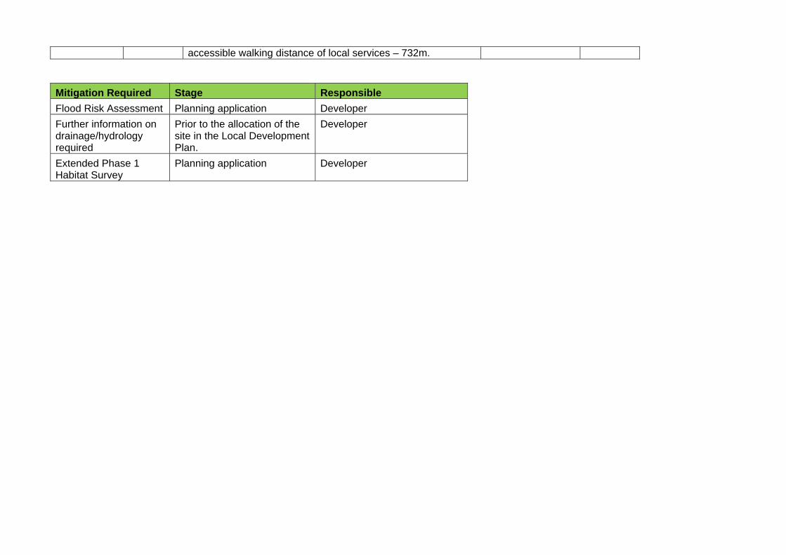
accessible walking distance of local services – 732m.
Mitigation Required Stage Responsible
Flood Risk Assessment Planning application Developer
Further information on drainage/hydrology required
Prior to the allocation of the site in the Local Development Plan.
Developer
Extended Phase 1 Habitat Survey
Planning application Developer
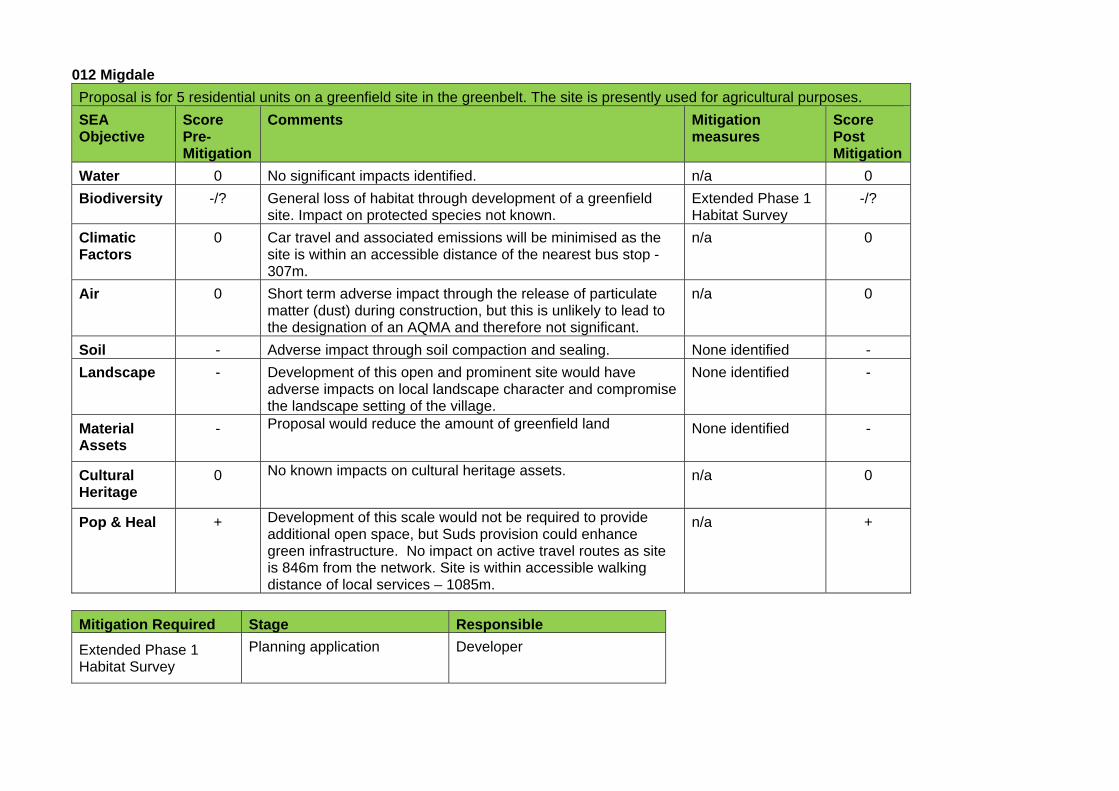
012 Migdale
Proposal is for 5 residential units on a greenfield site in the greenbelt. The site is presently used for agricultural purposes.
SEA Objective
Score Pre-Mitigation
Comments Mitigation measures
Score Post Mitigation
Water 0 No significant impacts identified. n/a 0
Biodiversity -/? General loss of habitat through development of a greenfield site. Impact on protected species not known.
Extended Phase 1 Habitat Survey
-/?
Climatic Factors
0 Car travel and associated emissions will be minimised as the site is within an accessible distance of the nearest bus stop - 307m.
n/a 0
Air 0 Short term adverse impact through the release of particulate matter (dust) during construction, but this is unlikely to lead to the designation of an AQMA and therefore not significant.
n/a 0
Soil - Adverse impact through soil compaction and sealing. None identified -
Landscape - Development of this open and prominent site would have adverse impacts on local landscape character and compromise the landscape setting of the village.
None identified -
Material Assets
- Proposal would reduce the amount of greenfield land None identified -
Cultural Heritage
0 No known impacts on cultural heritage assets. n/a 0
Pop & Heal + Development of this scale would not be required to provide additional open space, but Suds provision could enhance green infrastructure. No impact on active travel routes as site is 846m from the network. Site is within accessible walking distance of local services – 1085m.
n/a +
Mitigation Required Stage Responsible
Extended Phase 1 Habitat Survey
Planning application Developer
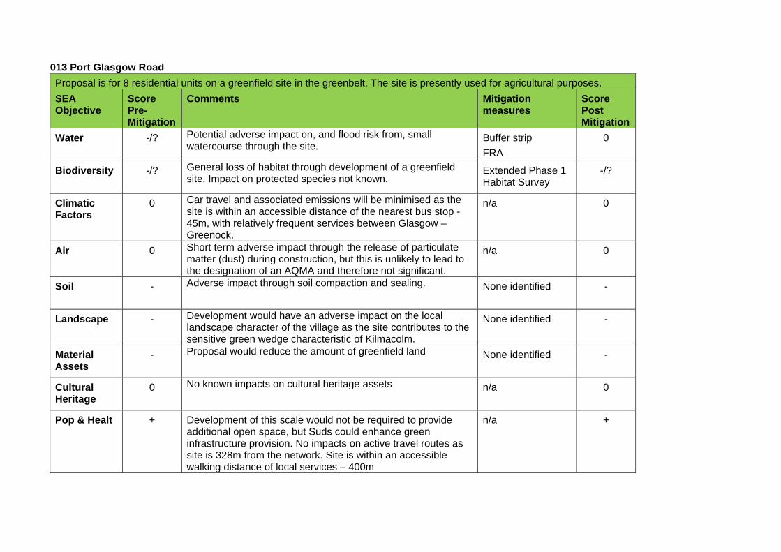
013 Port Glasgow Road
Proposal is for 8 residential units on a greenfield site in the greenbelt. The site is presently used for agricultural purposes.
SEA Objective
Score Pre-Mitigation
Comments Mitigation measures
Score Post Mitigation
Water -/? Potential adverse impact on, and flood risk from, small watercourse through the site.
Buffer strip
FRA
0
Biodiversity -/? General loss of habitat through development of a greenfield site. Impact on protected species not known.
Extended Phase 1 Habitat Survey
-/?
Climatic Factors
0 Car travel and associated emissions will be minimised as the site is within an accessible distance of the nearest bus stop - 45m, with relatively frequent services between Glasgow – Greenock.
n/a 0
Air 0 Short term adverse impact through the release of particulate matter (dust) during construction, but this is unlikely to lead to the designation of an AQMA and therefore not significant.
n/a 0
Soil - Adverse impact through soil compaction and sealing. None identified -
Landscape - Development would have an adverse impact on the local landscape character of the village as the site contributes to the sensitive green wedge characteristic of Kilmacolm.
None identified -
Material Assets
- Proposal would reduce the amount of greenfield land None identified -
Cultural Heritage
0 No known impacts on cultural heritage assets n/a 0
Pop & Healt + Development of this scale would not be required to provide additional open space, but Suds could enhance green infrastructure provision. No impacts on active travel routes as site is 328m from the network. Site is within an accessible walking distance of local services – 400m
n/a +
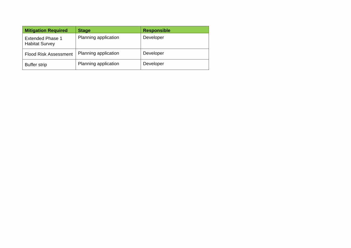
Mitigation Required Stage Responsible
Extended Phase 1 Habitat Survey
Planning application Developer
Flood Risk Assessment Planning application Developer
Buffer strip Planning application Developer
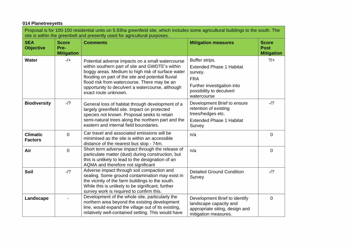
014 Planetreeyetts
Proposal is for 100-150 residential units on 5.93ha greenfield site, which includes some agricultural buildings to the south. The site is within the greenbelt and presently used for agricultural purposes.
SEA Objective
Score Pre-Mitigation
Comments Mitigation measures Score Post Mitigation
Water -/+ Potential adverse impacts on a small watercourse within southern part of site and GWDTE’s within boggy areas. Medium to high risk of surface water flooding on part of the site and potential fluvial flood risk from watercourse. There may be an opportunity to deculvert a watercourse, although exact route unknown.
Buffer strips.
Extended Phase 1 Habitat survey.
FRA
Further investigation into possibility to deculvert watercourse
?/+
Biodiversity -/? General loss of habitat through development of a largely greenfield site. Impact on protected species not known. Proposal seeks to retain semi-natural trees along the northern part and the eastern and internal field boundaries.
Development Brief to ensure retention of existing trees/hedges etc.
Extended Phase 1 Habitat Survey
-/?
Climatic Factors
0 Car travel and associated emissions will be minimised as the site is within an accessible distance of the nearest bus stop - 74m.
n/a 0
Air 0 Short term adverse impact through the release of particulate matter (dust) during construction, but this is unlikely to lead to the designation of an AQMA and therefore not significant
n/a 0
Soil -/? Adverse impact through soil compaction and sealing. Some ground contamination may exist in the vicinity of the farm buildings to the south. While this is unlikely to be significant, further survey work is required to confirm this.
Detailed Ground Condition Survey
-/?
Landscape - Development of the whole site, particularly the northern area beyond the existing development line, would expand the village out of its existing, relatively well-contained setting. This would have
Development Brief to identify landscape capacity and appropriate siting, design and mitigation measures.
0
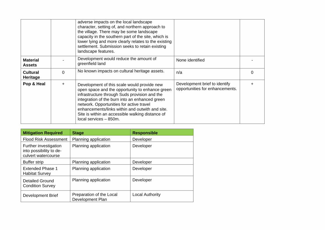
adverse impacts on the local landscape character, setting of, and northern approach to the village. There may be some landscape capacity in the southern part of the site, which is lower lying and more clearly relates to the existing settlement. Submission seeks to retain existing landscape features.
Material Assets
- Development would reduce the amount of greenfield land
None identified -
Cultural Heritage
0 No known impacts on cultural heritage assets. n/a 0
Pop & Heal + Development of this scale would provide new open space and the opportunity to enhance green infrastructure through Suds provision and the integration of the burn into an enhanced green network. Opportunities for active travel enhancements/links within and outwith and site. Site is within an accessible walking distance of local services – 850m.
Development brief to identify opportunities for enhancements.
+
Mitigation Required Stage Responsible
Flood Risk Assessment Planning application Developer
Further investigation into possibility to de-culvert watercourse
Planning application Developer
Buffer strip Planning application Developer
Extended Phase 1 Habitat Survey
Planning application Developer
Detailed Ground Condition Survey
Planning application Developer
Development Brief Preparation of the Local Development Plan
Local Authority
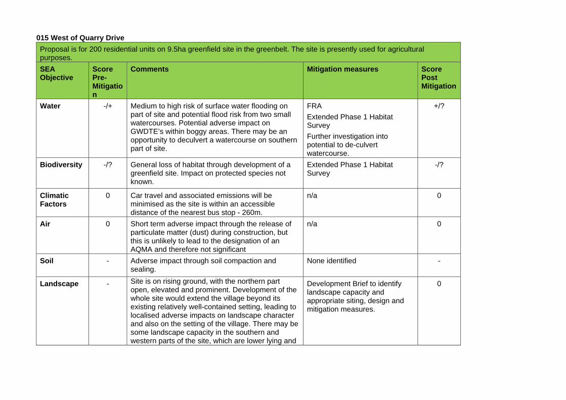
015 West of Quarry Drive
Proposal is for 200 residential units on 9.5ha greenfield site in the greenbelt. The site is presently used for agricultural purposes.
SEA Objective
Score Pre-Mitigation
Comments Mitigation measures Score Post Mitigation
Water -/+ Medium to high risk of surface water flooding on part of site and potential flood risk from two small watercourses. Potential adverse impact on GWDTE’s within boggy areas. There may be an opportunity to deculvert a watercourse on southern part of site.
FRA
Extended Phase 1 Habitat Survey
Further investigation into potential to de-culvert watercourse.
+/?
Biodiversity -/? General loss of habitat through development of a greenfield site. Impact on protected species not known.
Extended Phase 1 Habitat Survey
-/?
Climatic Factors
0 Car travel and associated emissions will be minimised as the site is within an accessible distance of the nearest bus stop - 260m.
n/a 0
Air 0 Short term adverse impact through the release of particulate matter (dust) during construction, but this is unlikely to lead to the designation of an AQMA and therefore not significant
n/a 0
Soil - Adverse impact through soil compaction and sealing.
None identified -
Landscape - Site is on rising ground, with the northern part open, elevated and prominent. Development of the whole site would extend the village beyond its existing relatively well-contained setting, leading to localised adverse impacts on landscape character and also on the setting of the village. There may be some landscape capacity in the southern and western parts of the site, which are lower lying and
Development Brief to identify landscape capacity and appropriate siting, design and mitigation measures.
0
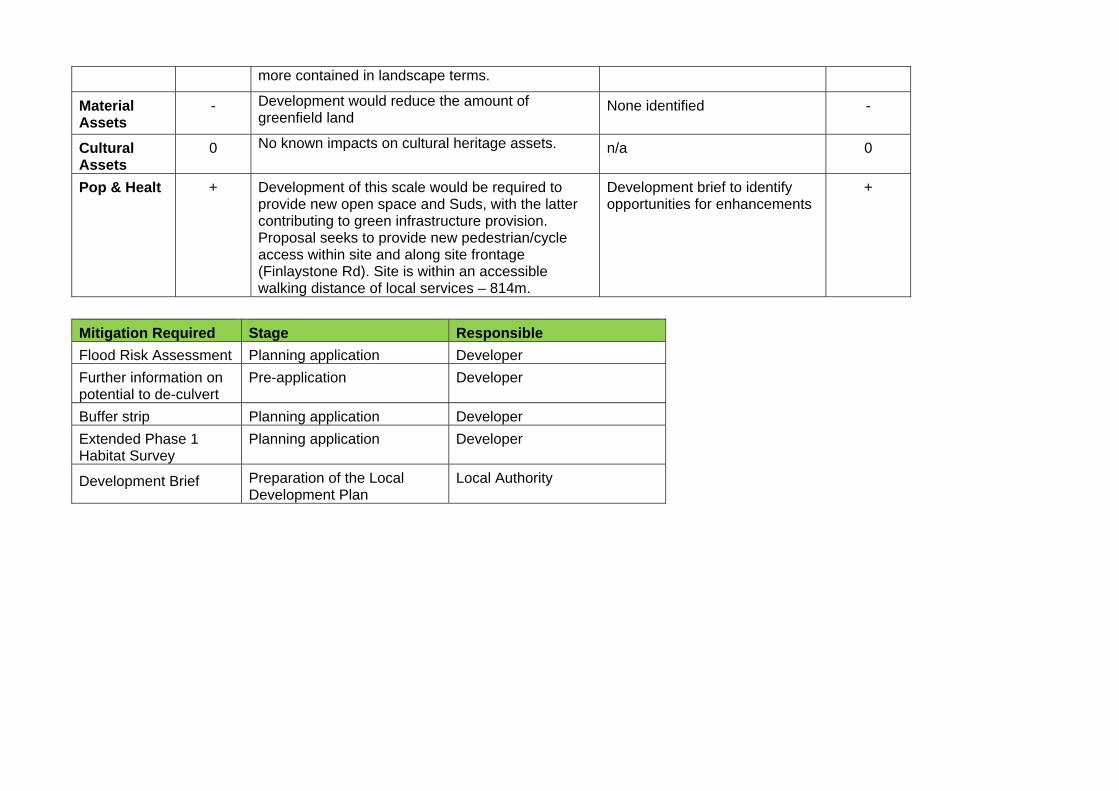
more contained in landscape terms.
Material Assets
- Development would reduce the amount of greenfield land
None identified -
Cultural Assets
0 No known impacts on cultural heritage assets. n/a 0
Pop & Healt + Development of this scale would be required to provide new open space and Suds, with the latter contributing to green infrastructure provision. Proposal seeks to provide new pedestrian/cycle access within site and along site frontage (Finlaystone Rd). Site is within an accessible walking distance of local services – 814m.
Development brief to identify opportunities for enhancements
+
Mitigation Required Stage Responsible
Flood Risk Assessment Planning application Developer
Further information on potential to de-culvert
Pre-application Developer
Buffer strip Planning application Developer
Extended Phase 1 Habitat Survey
Planning application Developer
Development Brief Preparation of the Local Development Plan
Local Authority
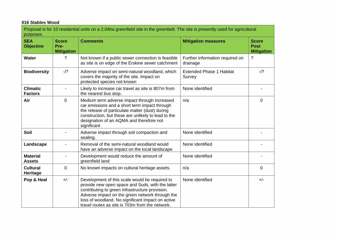
016 Stables Wood
Proposal is for 10 residential units on a 2.04ha greenfield site in the greenbelt. The site is presently used for agricultural purposes.
SEA Objective
Score Pre-Mitigation
Comments Mitigation measures Score Post Mitigation
Water ? Not known if a public sewer connection is feasible as site is on edge of the Erskine sewer catchment
Further information required on drainage
?
Biodiversity -/? Adverse impact on semi-natural woodland, which covers the majority of the site. Impact on protected species not known
Extended Phase 1 Habitat Survey
-/?
Climatic Factors
- Likely to increase car travel as site is 807m from the nearest bus stop.
None identified -
Air 0 Medium term adverse impact through increased car emissions and a short term impact through the release of particulate matter (dust) during construction, but these are unlikely to lead to the designation of an AQMA and therefore not significant
n/a 0
Soil - Adverse impact through soil compaction and sealing.
None identified -
Landscape - Removal of the semi-natural woodland would have an adverse impact on the local landscape
None identified -
Material Assets
- Development would reduce the amount of greenfield land
None identified -
Cultural Heritage
0 No known impacts on cultural heritage assets. n/a 0
Pop & Heal +/- Development of this scale would be required to provide new open space and Suds, with the latter contributing to green infrastructure provision. Adverse impact on the green network through the loss of woodland. No significant impact on active travel routes as site is 703m from the network.
None identified +/-
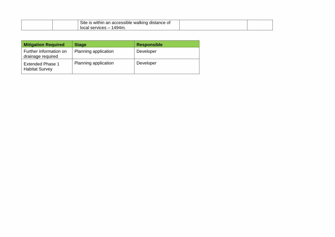
Site is within an accessible walking distance of local services – 1494m.
Mitigation Required Stage Responsible
Further information on drainage required
Planning application Developer
Extended Phase 1 Habitat Survey
Planning application Developer
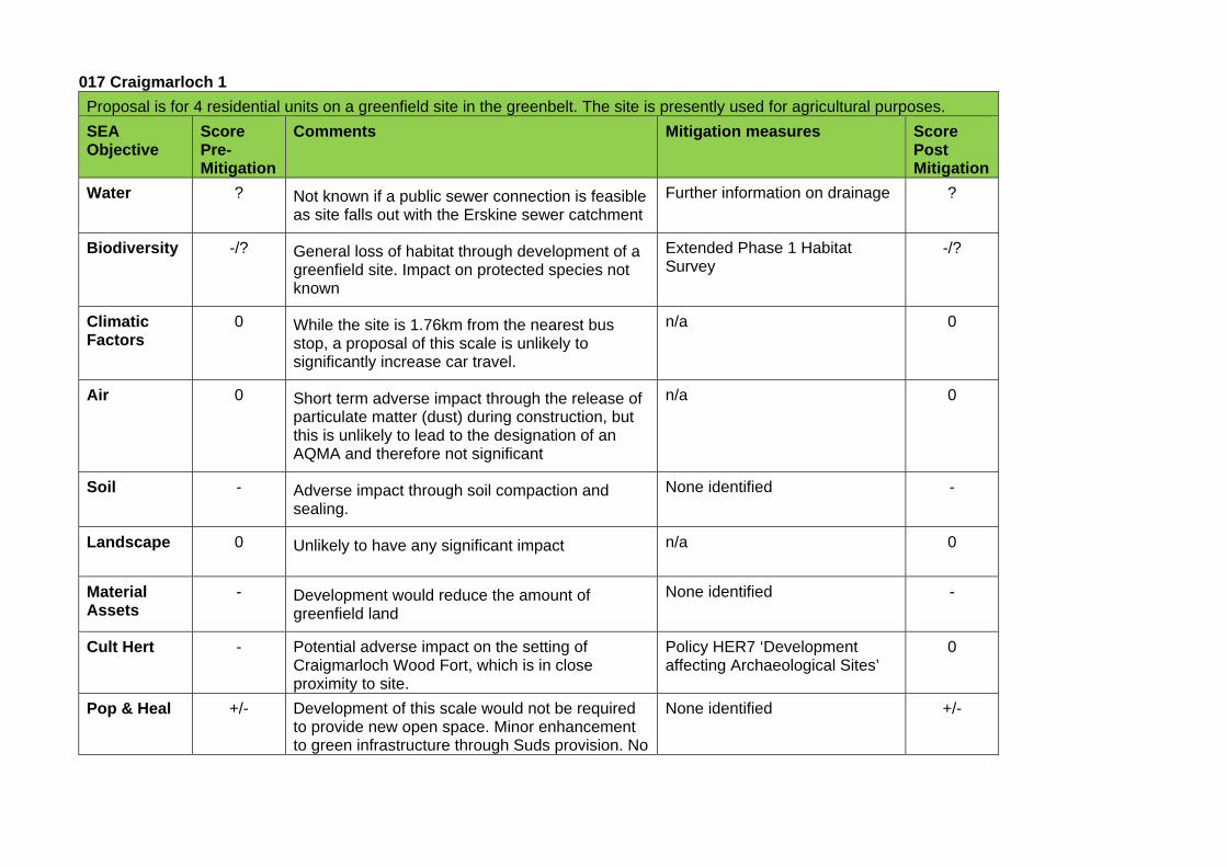
017 Craigmarloch 1
Proposal is for 4 residential units on a greenfield site in the greenbelt. The site is presently used for agricultural purposes.
SEA Objective
Score Pre-Mitigation
Comments Mitigation measures Score Post Mitigation
Water ? Not known if a public sewer connection is feasible as site falls out with the Erskine sewer catchment
Further information on drainage ?
Biodiversity -/? General loss of habitat through development of a greenfield site. Impact on protected species not known
Extended Phase 1 Habitat Survey
-/?
Climatic Factors
0 While the site is 1.76km from the nearest bus stop, a proposal of this scale is unlikely to significantly increase car travel.
n/a 0
Air 0 Short term adverse impact through the release of particulate matter (dust) during construction, but this is unlikely to lead to the designation of an AQMA and therefore not significant
n/a 0
Soil - Adverse impact through soil compaction and sealing.
None identified -
Landscape 0 Unlikely to have any significant impact n/a 0
Material Assets
- Development would reduce the amount of greenfield land
None identified -
Cult Hert - Potential adverse impact on the setting of Craigmarloch Wood Fort, which is in close proximity to site.
Policy HER7 ‘Development affecting Archaeological Sites’
0
Pop & Heal +/- Development of this scale would not be required to provide new open space. Minor enhancement to green infrastructure through Suds provision. No
None identified +/-
impact on active travel routes as site is1.27km from the network. Site is not within an accessible walking distance of local services – 2.4km.
Mitigation Required Stage Responsible
Further information on drainage
Planning application Developer
Extended Phase 1 Habitat Survey
Planning application Developer
Policy HER7 ‘Development affecting Archaeological Sites’
Planning application Local Authority
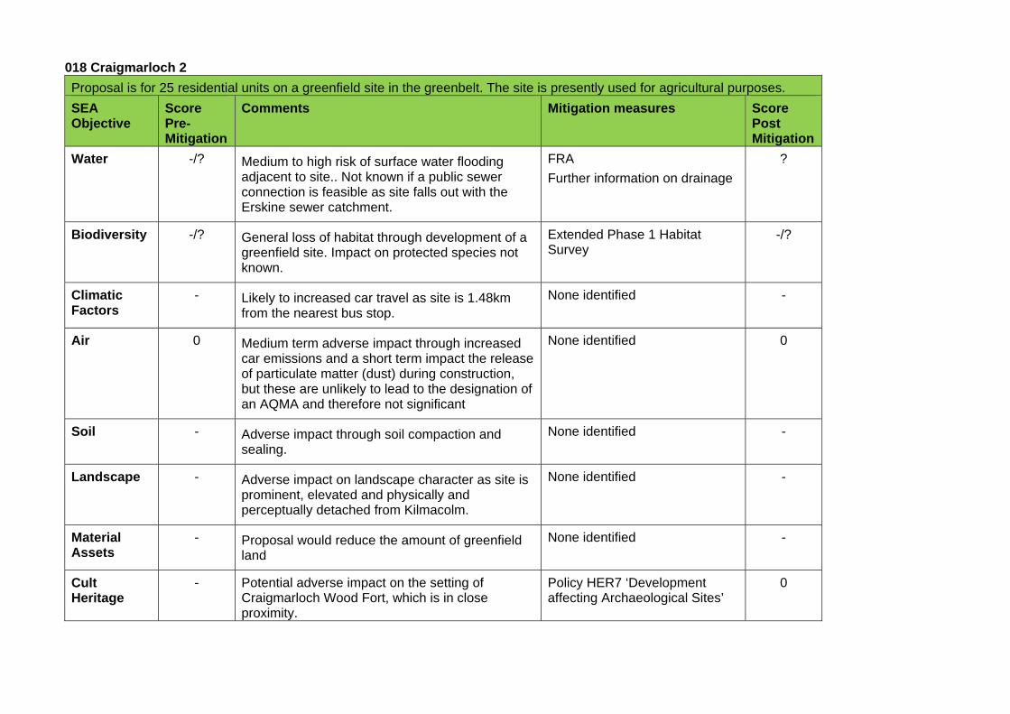
018 Craigmarloch 2
Proposal is for 25 residential units on a greenfield site in the greenbelt. The site is presently used for agricultural purposes.
SEA Objective
Score Pre-Mitigation
Comments Mitigation measures Score Post Mitigation
Water -/? Medium to high risk of surface water flooding adjacent to site.. Not known if a public sewer connection is feasible as site falls out with the Erskine sewer catchment.
FRA
Further information on drainage
?
Biodiversity -/? General loss of habitat through development of a greenfield site. Impact on protected species not known.
Extended Phase 1 Habitat Survey
-/?
Climatic Factors
- Likely to increased car travel as site is 1.48km from the nearest bus stop.
None identified -
Air 0 Medium term adverse impact through increased car emissions and a short term impact the release of particulate matter (dust) during construction, but these are unlikely to lead to the designation of an AQMA and therefore not significant
None identified 0
Soil - Adverse impact through soil compaction and sealing.
None identified -
Landscape - Adverse impact on landscape character as site is prominent, elevated and physically and perceptually detached from Kilmacolm.
None identified -
Material Assets
- Proposal would reduce the amount of greenfield land
None identified -
Cult Heritage
- Potential adverse impact on the setting of Craigmarloch Wood Fort, which is in close proximity.
Policy HER7 ‘Development affecting Archaeological Sites’
0
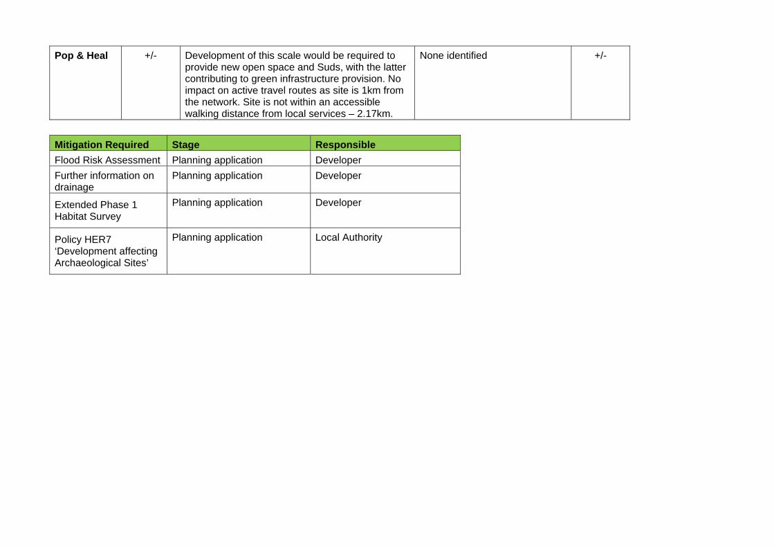
Pop & Heal +/- Development of this scale would be required to provide new open space and Suds, with the latter contributing to green infrastructure provision. No impact on active travel routes as site is 1km from the network. Site is not within an accessible walking distance from local services – 2.17km.
None identified +/-
Mitigation Required Stage Responsible
Flood Risk Assessment Planning application Developer
Further information on drainage
Planning application Developer
Extended Phase 1 Habitat Survey
Planning application Developer
Policy HER7 ‘Development affecting Archaeological Sites’
Planning application Local Authority
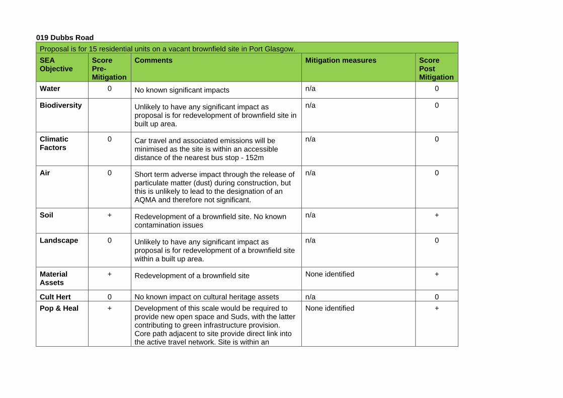
019 Dubbs Road
Proposal is for 15 residential units on a vacant brownfield site in Port Glasgow.
SEA Objective
Score Pre-Mitigation
Comments Mitigation measures Score Post Mitigation
Water 0 No known significant impacts n/a 0
Biodiversity Unlikely to have any significant impact as proposal is for redevelopment of brownfield site in built up area.
n/a 0
Climatic Factors
0 Car travel and associated emissions will be minimised as the site is within an accessible distance of the nearest bus stop - 152m
n/a 0
Air 0 Short term adverse impact through the release of particulate matter (dust) during construction, but this is unlikely to lead to the designation of an AQMA and therefore not significant.
n/a 0
Soil + Redevelopment of a brownfield site. No known contamination issues
n/a +
Landscape 0 Unlikely to have any significant impact as proposal is for redevelopment of a brownfield site within a built up area.
n/a 0
Material Assets
+ Redevelopment of a brownfield site None identified +
Cult Hert 0 No known impact on cultural heritage assets n/a 0
Pop & Heal + Development of this scale would be required to provide new open space and Suds, with the latter contributing to green infrastructure provision. Core path adjacent to site provide direct link into the active travel network. Site is within an
None identified +
accessible walking distance of local services – 150m
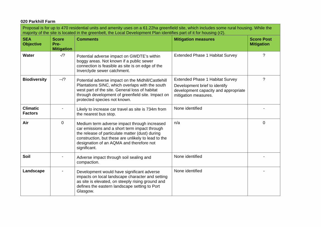
020 Parkhill Farm
Proposal is for up to 470 residential units and amenity uses on a 61.22ha greenfield site, which includes some rural housing. While the majority of the site is located in the greenbelt, the Local Development Plan identifies part of it for housing (r2).
SEA Objective
Score Pre-Mitigation
Comments Mitigation measures Score Post Mitigation
Water -/? Potential adverse impact on GWDTE’s within boggy areas. Not known if a public sewer connection is feasible as site is on edge of the Inverclyde sewer catchment.
Extended Phase 1 Habitat Survey ?
Biodiversity --/? Potential adverse impact on the Midhill/Castlehill Plantations SINC, which overlaps with the south west part of the site. General loss of habitat through development of greenfield site. Impact on protected species not known.
Extended Phase 1 Habitat Survey
Development brief to identify development capacity and appropriate mitigation measures.
?
Climatic Factors
- Likely to increase car travel as site is 734m from the nearest bus stop.
None identified -
Air 0 Medium term adverse impact through increased car emissions and a short term impact through the release of particulate matter (dust) during construction, but these are unlikely to lead to the designation of an AQMA and therefore not significant.
n/a 0
Soil - Adverse impact through soil sealing and compaction.
None identified -
Landscape - Development would have significant adverse impacts on local landscape character and setting as site is elevated, on steeply rising ground and defines the eastern landscape setting to Port Glasgow.
None identified -
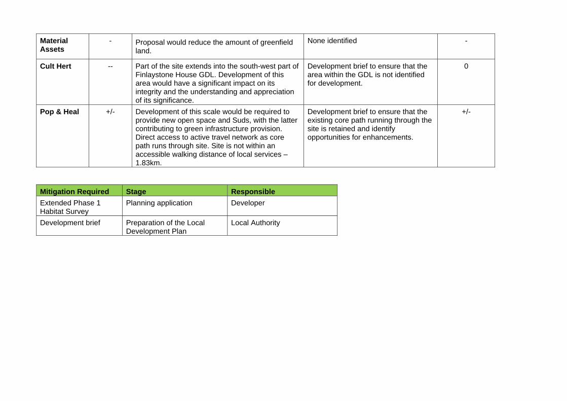
Material Assets
- Proposal would reduce the amount of greenfield land.
None identified -
Cult Hert -- Part of the site extends into the south-west part of Finlaystone House GDL. Development of this area would have a significant impact on its integrity and the understanding and appreciation of its significance.
Development brief to ensure that the area within the GDL is not identified for development.
0
Pop & Heal +/- Development of this scale would be required to provide new open space and Suds, with the latter contributing to green infrastructure provision. Direct access to active travel network as core path runs through site. Site is not within an accessible walking distance of local services – 1.83km.
Development brief to ensure that the existing core path running through the site is retained and identify opportunities for enhancements.
+/-
Mitigation Required Stage Responsible
Extended Phase 1 Habitat Survey
Planning application Developer
Development brief Preparation of the Local Development Plan
Local Authority

021 Parkhill
Proposal is for 50 residential units on a 2.4ha greenfield site in the greenbelt.
SEA Objective
Score Pre-Mitigation
Comments Mitigation measures Score Post Mitigation
Water -/? Potential adverse impact on GWDTE’s within boggy parts of site. Not known if a public sewer connection is feasible as site is on edge of Inverclyde sewer catchment.
Extended Phase 1 Habitat Survey
Further information on drainage
?
Biodiversity -/? General loss of habitat through development of greenfield site. Impact on protected species not known. Site is adjacent to Midhill/Castlehill SINC, but development is unlikely to impact on it
Extended Phase 1 Habitat Survey
-/?
Climatic Factors
- Likely to increase car travel as site is 734m from the nearest bus stop.
None identified -
Air 0 Medium term adverse impact through increased car emissions and a short term impact through the release of particulate matter (dust) during construction, but these are unlikely to lead to the designation of an AQMA and is therefore not significant
n/a 0
Soil - Adverse impact through soil sealing and compaction.
None identified -
Landscape - Development would have significant adverse impacts on local landscape character as site is elevated, on steeply rising ground, and physically, visually and perceptually detached from Port Glasgow.
None identified -
Material Assets
- Development would reduce the amount of greenfield land
None identified -
Cult Heritage
- Potential adverse impact on Finlaystone House GDL, which is in close proximity to site.
Policy HER7 ‘Development affecting Archaeological Sites’
0
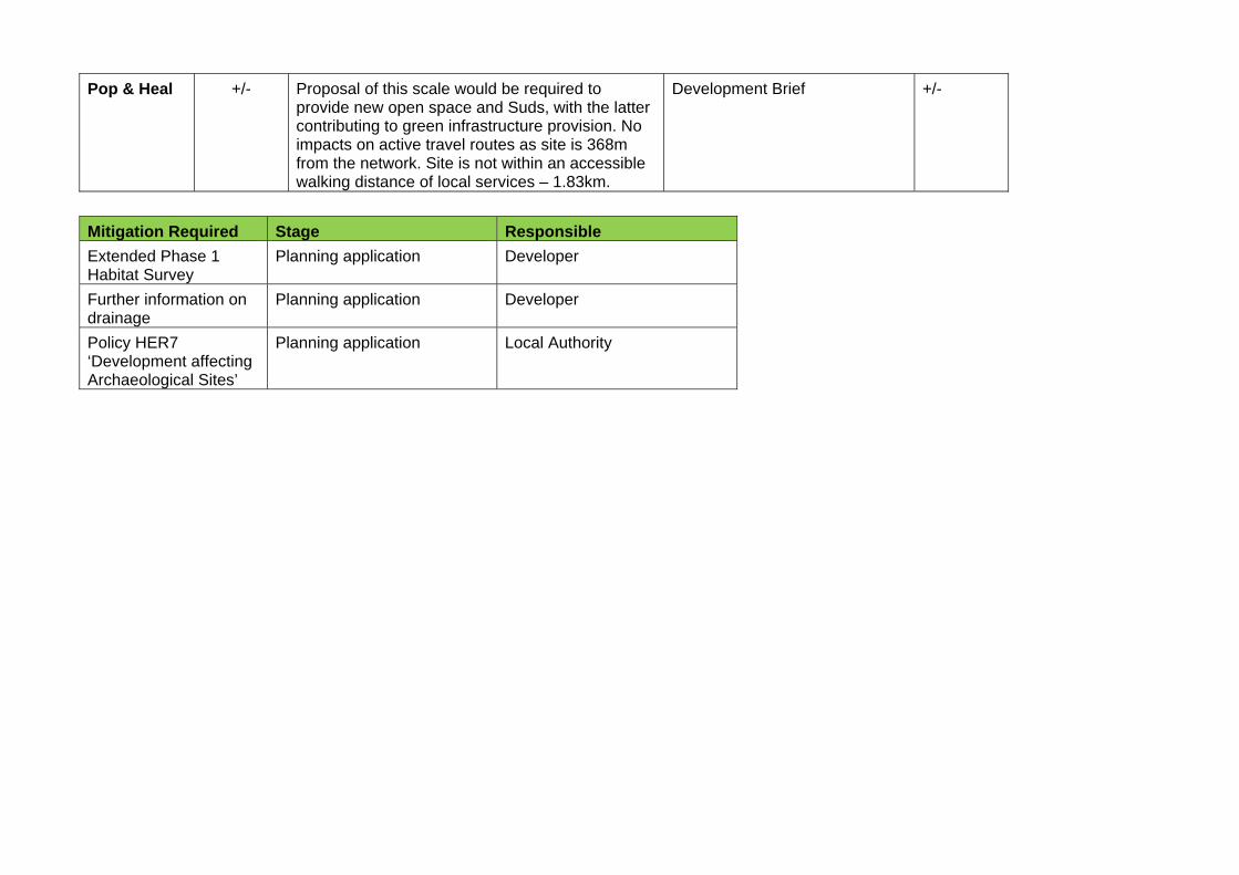
Pop & Heal +/- Proposal of this scale would be required to provide new open space and Suds, with the latter contributing to green infrastructure provision. No impacts on active travel routes as site is 368m from the network. Site is not within an accessible walking distance of local services – 1.83km.
Development Brief +/-
Mitigation Required Stage Responsible
Extended Phase 1 Habitat Survey
Planning application Developer
Further information on drainage
Planning application Developer
Policy HER7 ‘Development affecting Archaeological Sites’
Planning application Local Authority
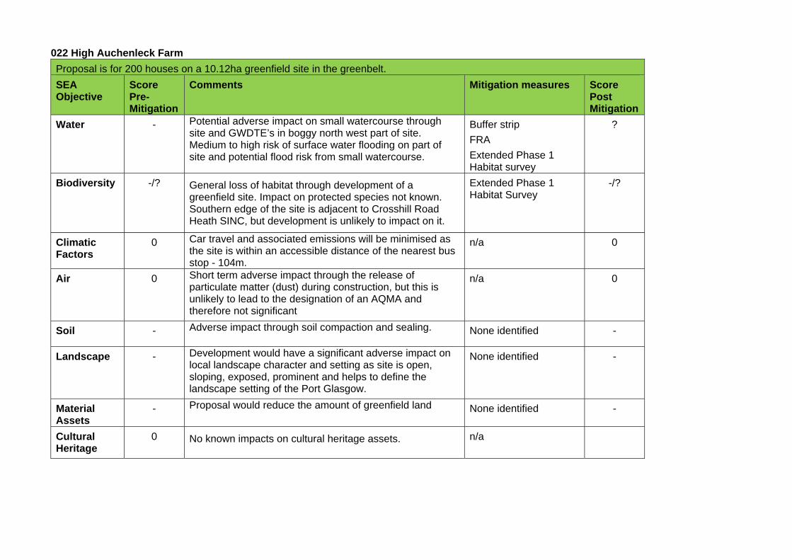
022 High Auchenleck Farm
Proposal is for 200 houses on a 10.12ha greenfield site in the greenbelt.
SEA Objective
Score Pre-Mitigation
Comments Mitigation measures Score Post Mitigation
Water - Potential adverse impact on small watercourse through site and GWDTE’s in boggy north west part of site. Medium to high risk of surface water flooding on part of site and potential flood risk from small watercourse.
Buffer strip
FRA
Extended Phase 1 Habitat survey
?
Biodiversity -/? General loss of habitat through development of a greenfield site. Impact on protected species not known. Southern edge of the site is adjacent to Crosshill Road Heath SINC, but development is unlikely to impact on it.
Extended Phase 1 Habitat Survey
-/?
Climatic Factors
0 Car travel and associated emissions will be minimised as the site is within an accessible distance of the nearest bus stop - 104m.
n/a 0
Air 0 Short term adverse impact through the release of particulate matter (dust) during construction, but this is unlikely to lead to the designation of an AQMA and therefore not significant
n/a 0
Soil - Adverse impact through soil compaction and sealing. None identified -
Landscape - Development would have a significant adverse impact on local landscape character and setting as site is open, sloping, exposed, prominent and helps to define the landscape setting of the Port Glasgow.
None identified -
Material Assets
- Proposal would reduce the amount of greenfield land None identified -
Cultural Heritage
0 No known impacts on cultural heritage assets. n/a
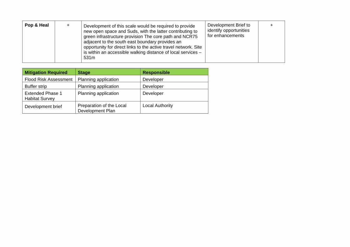
Pop & Heal + Development of this scale would be required to provide new open space and Suds, with the latter contributing to green infrastructure provision The core path and NCR75 adjacent to the south east boundary provides an opportunity for direct links to the active travel network. Site is within an accessible walking distance of local services – 531m
Development Brief to identify opportunities for enhancements
+
Mitigation Required Stage Responsible
Flood Risk Assessment Planning application Developer
Buffer strip Planning application Developer
Extended Phase 1 Habitat Survey
Planning application Developer
Development brief Preparation of the Local Development Plan
Local Authority
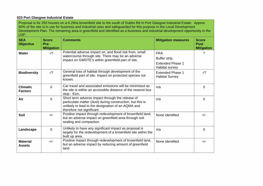
023 Port Glasgow Industrial Estate
Proposal is for 250 houses on a 6.29ha brownfield site to the south of Dubbs Rd in Port Glasgow Industrial Estate. Approx 60% of the site is in use for business and industrial uses and safeguarded for this purpose in the Local Development Development Plan. The remaining area is greenfield and identified as a business and industrial development opportunity in the LDP.
SEA Objective
Score Pre-Mitigation
Comments Mitigation measures Score Post Mitigation
Water -/? Potential adverse impact on, and flood risk from, small watercourse through site. There may be an adverse impact on GWDTE’s within greenfield part of site.
FRA
Buffer strip
Extended Phase 1 Habitat survey
?
Biodiversity -/? General loss of habitat through development of the greenfield part of site. Impact on protected species not known.
Extended Phase 1 Habitat Survey
-/?
Climatic Factors
0 Car travel and associated emissions will be minimised as the site is within an accessible distance of the nearest bus stop - 81m.
n/a 0
Air 0 Short term adverse impact through the release of particulate matter (dust) during construction, but this is unlikely to lead to the designation of an AQMA and therefore not significant
n/a 0
Soil +/- Positive impact through redevelopment of brownfield land, but an adverse impact on greenfield area through soil sealing and compaction.
None identified +/-
Landscape 0 Unlikely to have any significant impact as proposal is largely for the redevelopment of a brownfield site within the built up area.
n/a 0
Material Assets
+/- Positive impact through redevelopment of brownfield land, but an adverse impact by reducing amount of greenfield land
None identified +/-
Cultural Assets
0 No known impacts on cultural heritage assets n/a 0
Pop & Heal + Development of this scale would be required to provide new open space and Suds, with the latter contributing to green infrastructure provision. The core path adjacent to western boundary and within north west part of site provides opportunity for a direct link to the active travel network. Site is within an accessible walking distance of local services – 668m.
n/a +
Mitigation Required Stage Responsible
Flood Risk Assessment Planning application Developer
Buffer strip Planning application Developer
Extended Phase 1 Habitat Survey
Planning application Developer
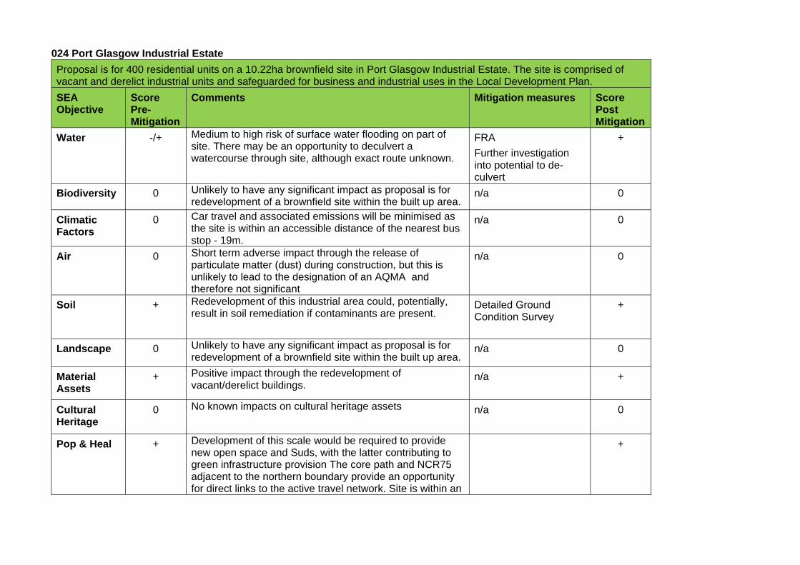
024 Port Glasgow Industrial Estate
Proposal is for 400 residential units on a 10.22ha brownfield site in Port Glasgow Industrial Estate. The site is comprised of vacant and derelict industrial units and safeguarded for business and industrial uses in the Local Development Plan.
SEA Objective
Score Pre-Mitigation
Comments Mitigation measures Score Post Mitigation
Water -/+ Medium to high risk of surface water flooding on part of site. There may be an opportunity to deculvert a watercourse through site, although exact route unknown.
FRA
Further investigation into potential to de-culvert
+
Biodiversity 0 Unlikely to have any significant impact as proposal is for redevelopment of a brownfield site within the built up area.
n/a 0
Climatic Factors
0 Car travel and associated emissions will be minimised as the site is within an accessible distance of the nearest bus stop - 19m.
n/a 0
Air 0 Short term adverse impact through the release of particulate matter (dust) during construction, but this is unlikely to lead to the designation of an AQMA and therefore not significant
n/a 0
Soil + Redevelopment of this industrial area could, potentially, result in soil remediation if contaminants are present.
Detailed Ground Condition Survey
+
Landscape 0 Unlikely to have any significant impact as proposal is for redevelopment of a brownfield site within the built up area.
n/a 0
Material Assets
+ Positive impact through the redevelopment of vacant/derelict buildings.
n/a +
Cultural Heritage
0 No known impacts on cultural heritage assets n/a 0
Pop & Heal + Development of this scale would be required to provide new open space and Suds, with the latter contributing to green infrastructure provision The core path and NCR75 adjacent to the northern boundary provide an opportunity for direct links to the active travel network. Site is within an
+
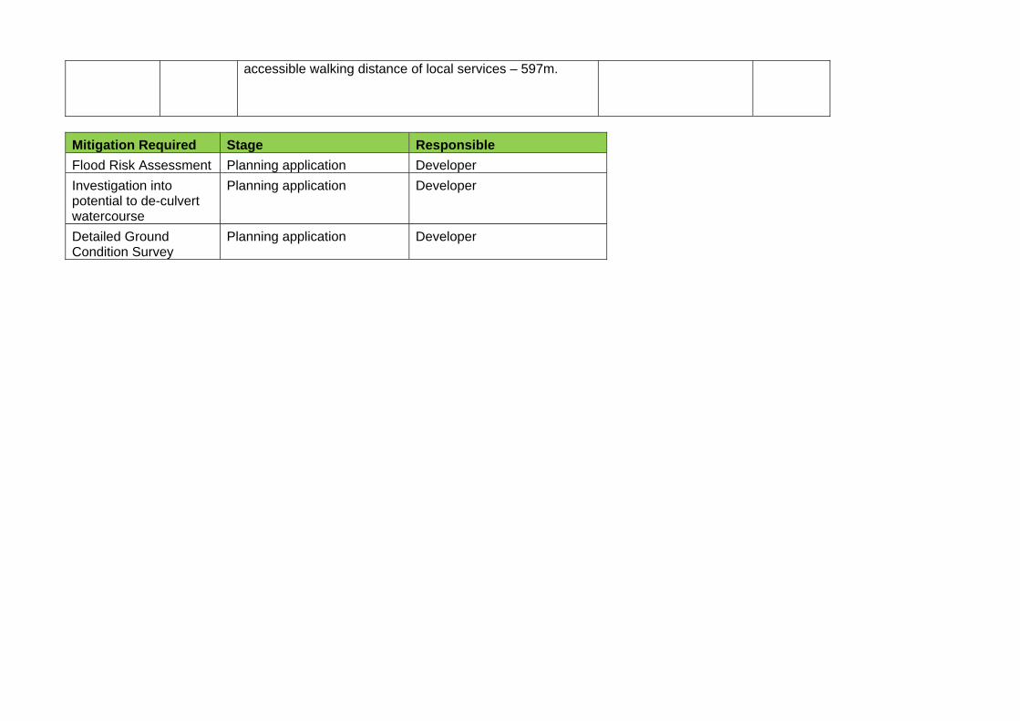
accessible walking distance of local services – 597m.
Mitigation Required Stage Responsible
Flood Risk Assessment Planning application Developer
Investigation into potential to de-culvert watercourse
Planning application Developer
Detailed Ground Condition Survey
Planning application Developer
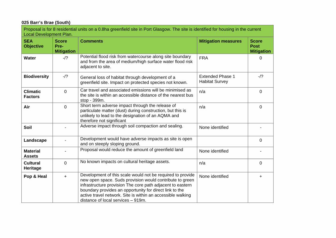
025 Barr’s Brae (South)
Proposal is for 8 residential units on a 0.8ha greenfield site in Port Glasgow. The site is identified for housing in the current Local Development Plan.
SEA Objective
Score Pre-Mitigation
Comments Mitigation measures Score Post Mitigation
Water -/? Potential flood risk from watercourse along site boundary and from the area of medium/high surface water flood risk adjacent to site.
FRA
0
Biodiversity -/? General loss of habitat through development of a greenfield site. Impact on protected species not known.
Extended Phase 1 Habitat Survey
-/?
Climatic Factors
0 Car travel and associated emissions will be minimised as the site is within an accessible distance of the nearest bus stop - 399m.
n/a 0
Air 0 Short term adverse impact through the release of particulate matter (dust) during construction, but this is unlikely to lead to the designation of an AQMA and therefore not significant
n/a 0
Soil - Adverse impact through soil compaction and sealing. None identified -
Landscape - Development would have adverse impacts as site is open and on steeply sloping ground.
0
Material Assets
- Proposal would reduce the amount of greenfield land None identified -
Cultural Heritage
0 No known impacts on cultural heritage assets. n/a 0
Pop & Heal + Development of this scale would not be required to provide new open space. Suds provision would contribute to green infrastructure provision The core path adjacent to eastern boundary provides an opportunity for direct link to the active travel network. Site is within an accessible walking distance of local services – 919m.
None identified +
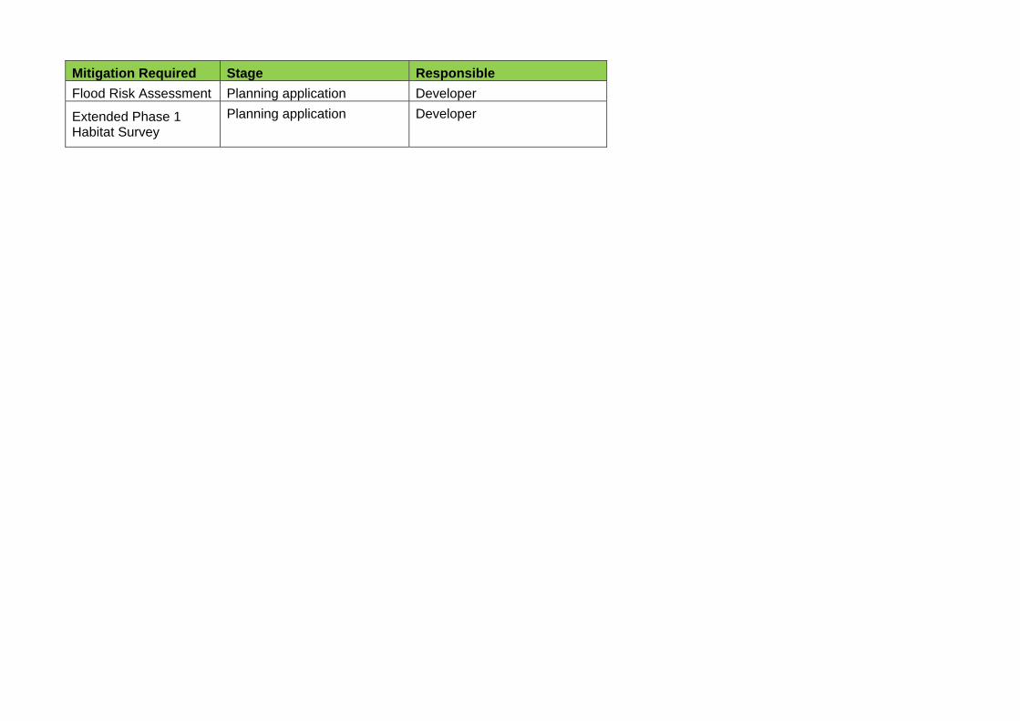
Mitigation Required Stage Responsible
Flood Risk Assessment Planning application Developer
Extended Phase 1 Habitat Survey
Planning application Developer
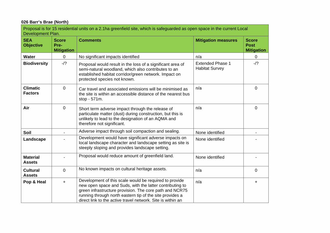
026 Barr’s Brae (North)
Proposal is for 15 residential units on a 2.1ha greenfield site, which is safeguarded as open space in the current Local Development Plan.
SEA Objective
Score Pre-Mitigation
Comments Mitigation measures Score Post Mitigation
Water 0 No significant impacts identified n/a 0
Biodiversity -/? Proposal would result in the loss of a significant area of semi-natural woodland, which also contributes to an established habitat corridor/green network. Impact on protected species not known.
Extended Phase 1 Habitat Survey
-/?
Climatic Factors
0 Car travel and associated emissions will be minimised as the site is within an accessible distance of the nearest bus stop - 571m.
n/a 0
Air 0 Short term adverse impact through the release of particulate matter (dust) during construction, but this is unlikely to lead to the designation of an AQMA and therefore not significant.
n/a 0
Soil - Adverse impact through soil compaction and sealing. None identified -
Landscape - Development would have significant adverse impacts on local landscape character and landscape setting as site is steeply sloping and provides landscape setting.
None identified
-
Material Assets
- Proposal would reduce amount of greenfield land. None identified -
Cultural Assets
0 No known impacts on cultural heritage assets. n/a 0
Pop & Heal + Development of this scale would be required to provide new open space and Suds, with the latter contributing to green infrastructure provision. The core path and NCR75 running through north eastern tip of the site provides a direct link to the active travel network. Site is within an
n/a +
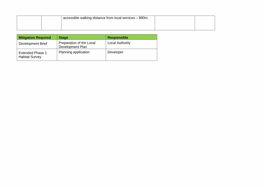
accessible walking distance from local services – 890m.
Mitigation Required Stage Responsible
Development Brief Preparation of the Local Development Plan
Local Authority
Extended Phase 1 Habitat Survey
Planning application Developer
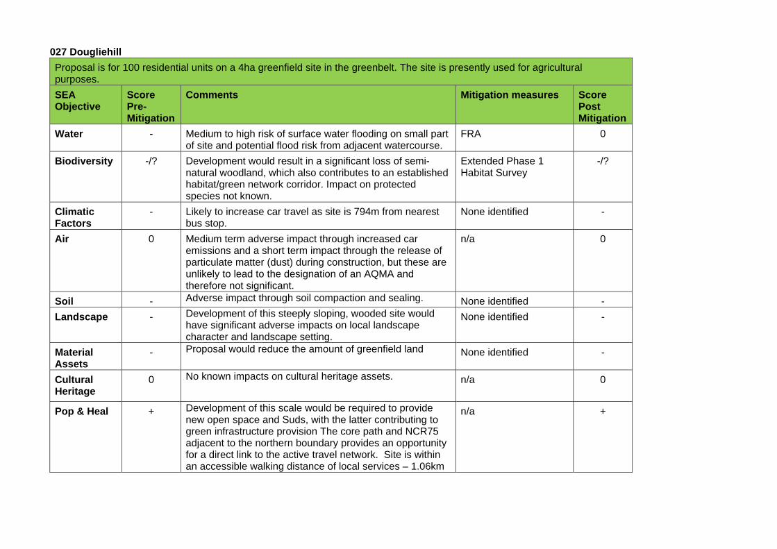
027 Dougliehill
Proposal is for 100 residential units on a 4ha greenfield site in the greenbelt. The site is presently used for agricultural purposes.
SEA Objective
Score Pre-Mitigation
Comments Mitigation measures Score Post Mitigation
Water - Medium to high risk of surface water flooding on small part of site and potential flood risk from adjacent watercourse.
FRA 0
Biodiversity -/? Development would result in a significant loss of semi-natural woodland, which also contributes to an established habitat/green network corridor. Impact on protected species not known.
Extended Phase 1 Habitat Survey
-/?
Climatic Factors
- Likely to increase car travel as site is 794m from nearest bus stop.
None identified -
Air 0 Medium term adverse impact through increased car emissions and a short term impact through the release of particulate matter (dust) during construction, but these are unlikely to lead to the designation of an AQMA and therefore not significant.
n/a 0
Soil - Adverse impact through soil compaction and sealing. None identified -
Landscape - Development of this steeply sloping, wooded site would have significant adverse impacts on local landscape character and landscape setting.
None identified -
Material Assets
- Proposal would reduce the amount of greenfield land None identified -
Cultural Heritage
0 No known impacts on cultural heritage assets. n/a 0
Pop & Heal + Development of this scale would be required to provide new open space and Suds, with the latter contributing to green infrastructure provision The core path and NCR75 adjacent to the northern boundary provides an opportunity for a direct link to the active travel network. Site is within an accessible walking distance of local services – 1.06km
n/a +
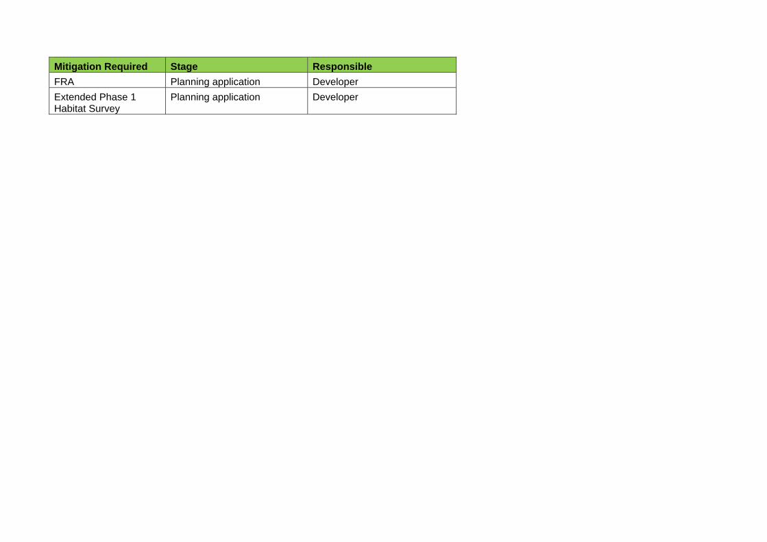
Mitigation Required Stage Responsible
FRA Planning application Developer
Extended Phase 1 Habitat Survey
Planning application Developer
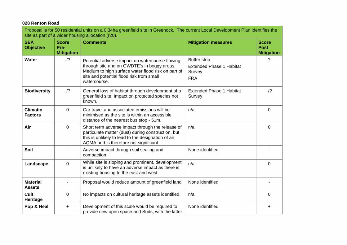
028 Renton Road
Proposal is for 50 residential units on a 0.34ha greenfield site in Greenock. The current Local Development Plan identifies the site as part of a wider housing allocation (r20).
SEA Objective
Score Pre-Mitigation
Comments Mitigation measures Score Post Mitigation
Water -/? Potential adverse impact on watercourse flowing through site and on GWDTE’s in boggy areas. Medium to high surface water flood risk on part of site and potential flood risk from small watercourse.
Buffer strip
Extended Phase 1 Habitat Survey
FRA
?
Biodiversity -/? General loss of habitat through development of a greenfield site. Impact on protected species not known.
Extended Phase 1 Habitat Survey
-/?
Climatic Factors
0 Car travel and associated emissions will be minimised as the site is within an accessible distance of the nearest bus stop - 51m.
n/a 0
Air 0 Short term adverse impact through the release of particulate matter (dust) during construction, but this is unlikely to lead to the designation of an AQMA and is therefore not significant
n/a 0
Soil - Adverse impact through soil sealing and compaction
None identified -
Landscape 0 While site is sloping and prominent, development is unlikely to have an adverse impact as there is existing housing to the east and west.
n/a 0
Material Assets
- Proposal would reduce amount of greenfield land None identified -
Cult Heritage
0 No impacts on cultural heritage assets identified. n/a 0
Pop & Heal + Development of this scale would be required to provide new open space and Suds, with the latter
None identified +
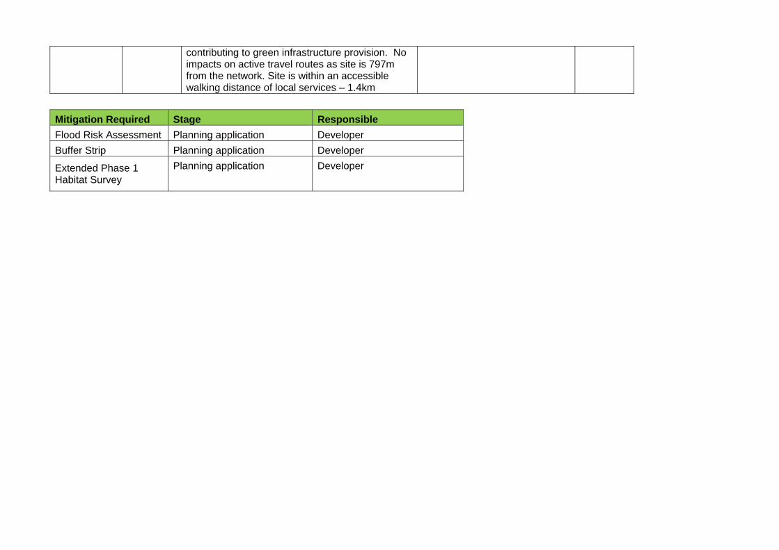
contributing to green infrastructure provision. No impacts on active travel routes as site is 797m from the network. Site is within an accessible walking distance of local services – 1.4km
Mitigation Required Stage Responsible
Flood Risk Assessment Planning application Developer
Buffer Strip Planning application Developer
Extended Phase 1 Habitat Survey
Planning application Developer
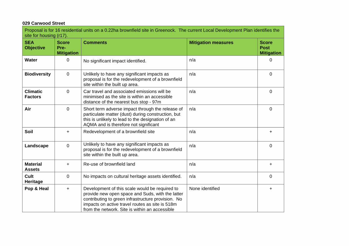
029 Carwood Street
Proposal is for 16 residential units on a 0.22ha brownfield site in Greenock. The current Local Development Plan identifies the site for housing (r17).
SEA Objective
Score Pre-Mitigation
Comments Mitigation measures Score Post Mitigation
Water 0 No significant impact identified. n/a 0
Biodiversity 0 Unlikely to have any significant impacts as proposal is for the redevelopment of a brownfield site within the built up area.
n/a 0
Climatic Factors
0 Car travel and associated emissions will be minimised as the site is within an accessible distance of the nearest bus stop - 97m
n/a 0
Air 0 Short term adverse impact through the release of particulate matter (dust) during construction, but this is unlikely to lead to the designation of an AQMA and is therefore not significant
n/a 0
Soil + Redevelopment of a brownfield site n/a +
Landscape 0 Unlikely to have any significant impacts as proposal is for the redevelopment of a brownfield site within the built up area.
n/a 0
Material Assets
+ Re-use of brownfield land n/a +
Cult Heritage
0 No impacts on cultural heritage assets identified. n/a 0
Pop & Heal + Development of this scale would be required to provide new open space and Suds, with the latter contributing to green infrastructure provision. No impacts on active travel routes as site is 518m from the network. Site is within an accessible
None identified +
walking distance of local services – 518m

030 King Street Car Park
Proposal is for 35 residential units on a 0.6ha brownfield site in Greenock Town centre. Site is currently used as a car park.
SEA Objective
Score Pre-Mitigation
Comments Mitigation measures Score Post Mitigation
Water - Medium to high surface water flood risk on part of site. FRA 0
Biodiversity 0 Unlikely to have any significant impact as proposal is for redevelopment of a brownfield site within the built up area.
n/a 0
Climatic Factors
0 Car travel and associated emissions will be minimised as the site is within an accessible distance of the nearest bus stop - 393m.
n/a 0
Air 0 Short term adverse impact on air quality through the release of particulate matter (dust) during construction, but this is unlikely to lead to the designation of an AQMA and is therefore not significant
n/a 0
Soil + Redevelopment of brownfield site. No known contamination issues
n/a +
Landscape 0 Unlikely to have any significant impact as proposal is for redevelopment of a brownfield site within the built up area.
n/a 0
Material Assets
+ Re-use of brownfield land n/a +
Cultural Assets
0 No known impacts on cultural heritage assets. n/a 0
Pop & Heal + Development of this scale would be required to provide new open space and Suds, with the latter contributing to green infrastructure provision No impact on active travel routes as site is 561m from the network. Within an accessible walking distance of local services as site within town centre.
None identified +
Mitigation Required Stage Responsible
FRA Planning application Developer
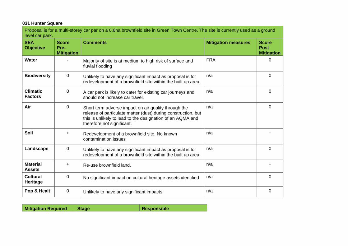
031 Hunter Square
Proposal is for a multi-storey car par on a 0.6ha brownfield site in Green Town Centre. The site is currently used as a ground level car park.
SEA Objective
Score Pre-Mitigation
Comments Mitigation measures Score Post Mitigation
Water - Majority of site is at medium to high risk of surface and fluvial flooding
FRA
0
Biodiversity 0 Unlikely to have any significant impact as proposal is for redevelopment of a brownfield site within the built up area.
n/a 0
Climatic Factors
0 A car park is likely to cater for existing car journeys and should not increase car travel.
n/a 0
Air 0 Short term adverse impact on air quality through the release of particulate matter (dust) during construction, but this is unlikely to lead to the designation of an AQMA and therefore not significant.
n/a 0
Soil + Redevelopment of a brownfield site. No known contamination issues
n/a +
Landscape 0 Unlikely to have any significant impact as proposal is for redevelopment of a brownfield site within the built up area.
n/a 0
Material Assets
+ Re-use brownfield land. n/a +
Cultural Heritage
0 No significant impact on cultural heritage assets identified n/a 0
Pop & Healt 0 Unlikely to have any significant impacts n/a 0
Mitigation Required Stage Responsible

Flood Risk Assessment Planning application Developer
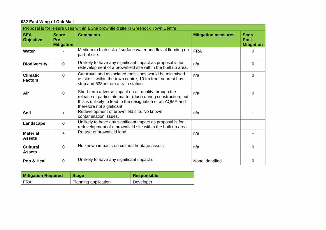
032 East Wing of Oak Mall
Proposal is for leisure uses within a 3ha brownfield site in Greenock Town Centre.
SEA Objective
Score Pre-Mitigation
Comments Mitigation measures Score Post Mitigation
Water - Medium to high risk of surface water and fluvial flooding on part of site.
FRA
0
Biodiversity 0 Unlikely to have any significant impact as proposal is for redevelopment of a brownfield site within the built up area.
n/a 0
Climatic Factors
0 Car travel and associated emissions would be minimised as site is within the town centre, 101m from nearest bus stop and 638m from a train station.
n/a 0
Air 0 Short term adverse impact on air quality through the release of particulate matter (dust) during construction, but this is unlikely to lead to the designation of an AQMA and therefore not significant.
n/a 0
Soil + Redevelopment of brownfield site. No known contamination issues.
n/a +
Landscape 0 Unlikely to have any significant impact as proposal is for redevelopment of a brownfield site within the built up area.
Material Assets
+ Re-use of brownfield land. n/a +
Cultural Assets
0 No known impacts on cultural heritage assets n/a 0
Pop & Heal 0 Unlikely to have any significant impact s None identified 0
Mitigation Required Stage Responsible
FRA Planning application Developer
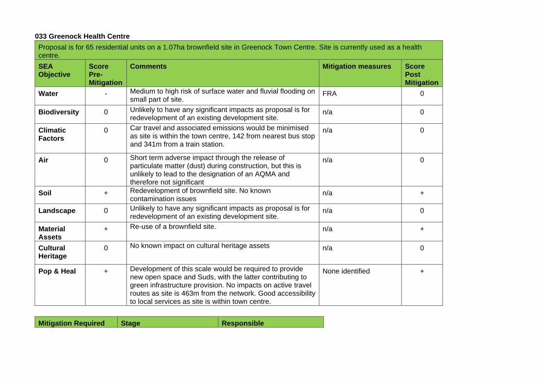
033 Greenock Health Centre
Proposal is for 65 residential units on a 1.07ha brownfield site in Greenock Town Centre. Site is currently used as a health centre.
SEA Objective
Score Pre-Mitigation
Comments Mitigation measures Score Post Mitigation
Water - Medium to high risk of surface water and fluvial flooding on small part of site.
FRA 0
Biodiversity 0 Unlikely to have any significant impacts as proposal is for redevelopment of an existing development site.
n/a 0
Climatic Factors
0 Car travel and associated emissions would be minimised as site is within the town centre, 142 from nearest bus stop and 341m from a train station.
n/a 0
Air 0 Short term adverse impact through the release of particulate matter (dust) during construction, but this is unlikely to lead to the designation of an AQMA and therefore not significant
n/a 0
Soil + Redevelopment of brownfield site. No known contamination issues
n/a +
Landscape 0 Unlikely to have any significant impacts as proposal is for redevelopment of an existing development site.
n/a 0
Material Assets
+ Re-use of a brownfield site. n/a +
Cultural Heritage
0 No known impact on cultural heritage assets n/a 0
Pop & Heal + Development of this scale would be required to provide new open space and Suds, with the latter contributing to green infrastructure provision. No impacts on active travel routes as site is 463m from the network. Good accessibility to local services as site is within town centre.
None identified +
Mitigation Required Stage Responsible

Flood Risk Assessment Planning application Developer
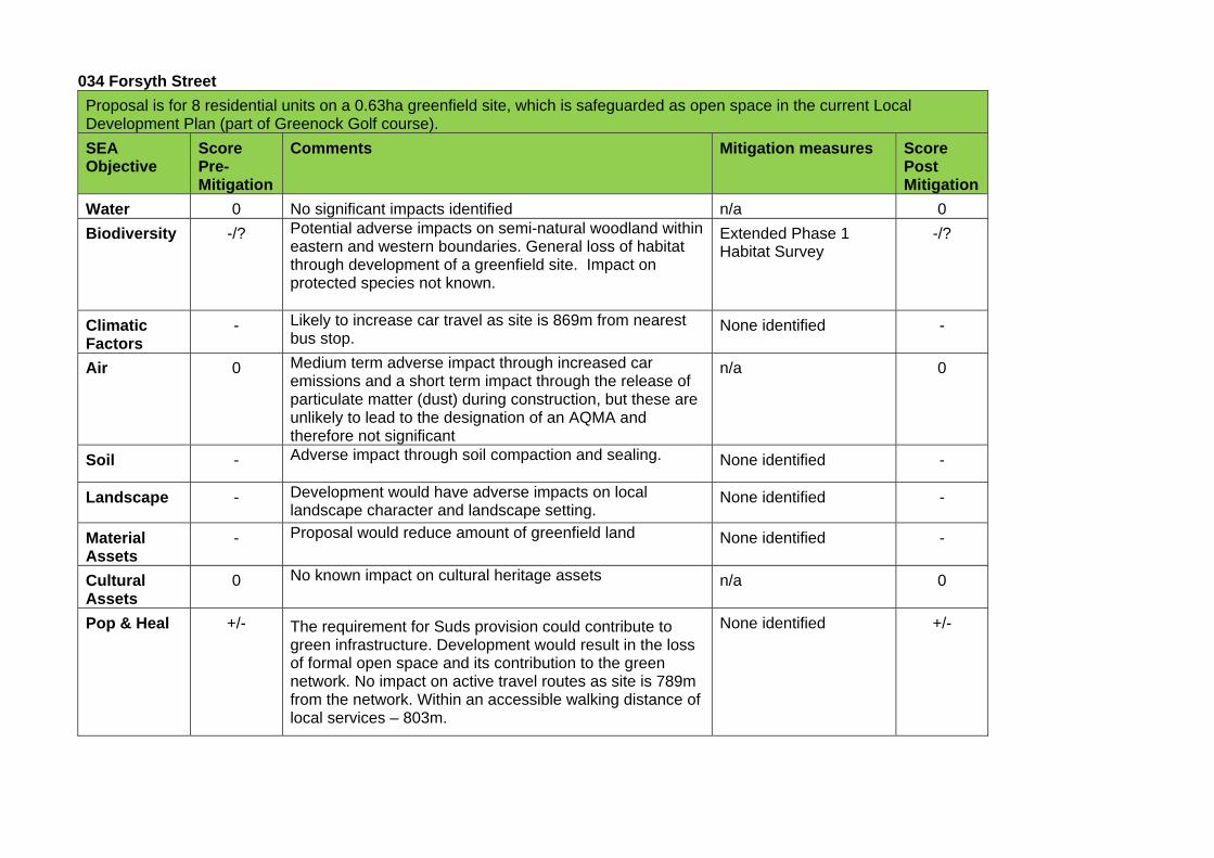
034 Forsyth Street
Proposal is for 8 residential units on a 0.63ha greenfield site, which is safeguarded as open space in the current Local Development Plan (part of Greenock Golf course).
SEA Objective
Score Pre-Mitigation
Comments Mitigation measures Score Post Mitigation
Water 0 No significant impacts identified n/a 0
Biodiversity -/? Potential adverse impacts on semi-natural woodland within eastern and western boundaries. General loss of habitat through development of a greenfield site. Impact on protected species not known.
Extended Phase 1 Habitat Survey
-/?
Climatic Factors
- Likely to increase car travel as site is 869m from nearest bus stop.
None identified -
Air 0 Medium term adverse impact through increased car emissions and a short term impact through the release of particulate matter (dust) during construction, but these are unlikely to lead to the designation of an AQMA and therefore not significant
n/a 0
Soil - Adverse impact through soil compaction and sealing. None identified -
Landscape - Development would have adverse impacts on local landscape character and landscape setting.
None identified -
Material Assets
- Proposal would reduce amount of greenfield land None identified -
Cultural Assets
0 No known impact on cultural heritage assets n/a 0
Pop & Heal +/- The requirement for Suds provision could contribute to green infrastructure. Development would result in the loss of formal open space and its contribution to the green network. No impact on active travel routes as site is 789m from the network. Within an accessible walking distance of local services – 803m.
None identified +/-
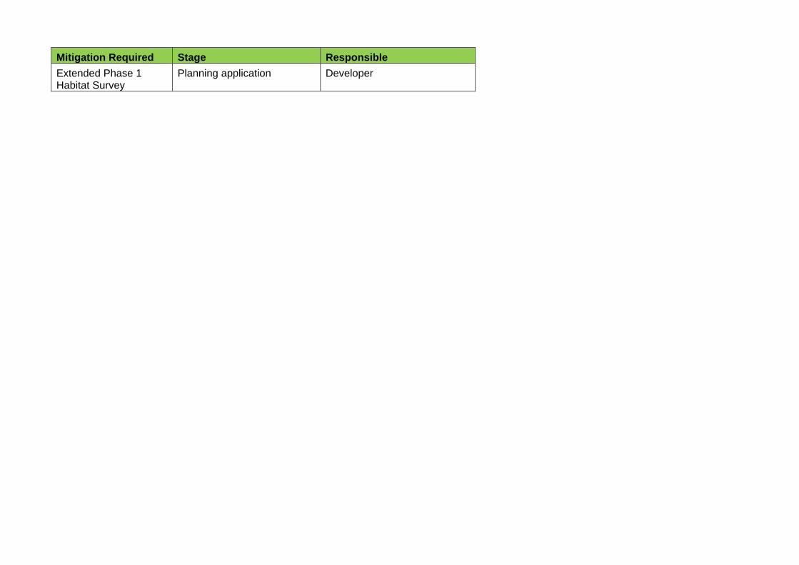
Mitigation Required Stage Responsible
Extended Phase 1 Habitat Survey
Planning application Developer
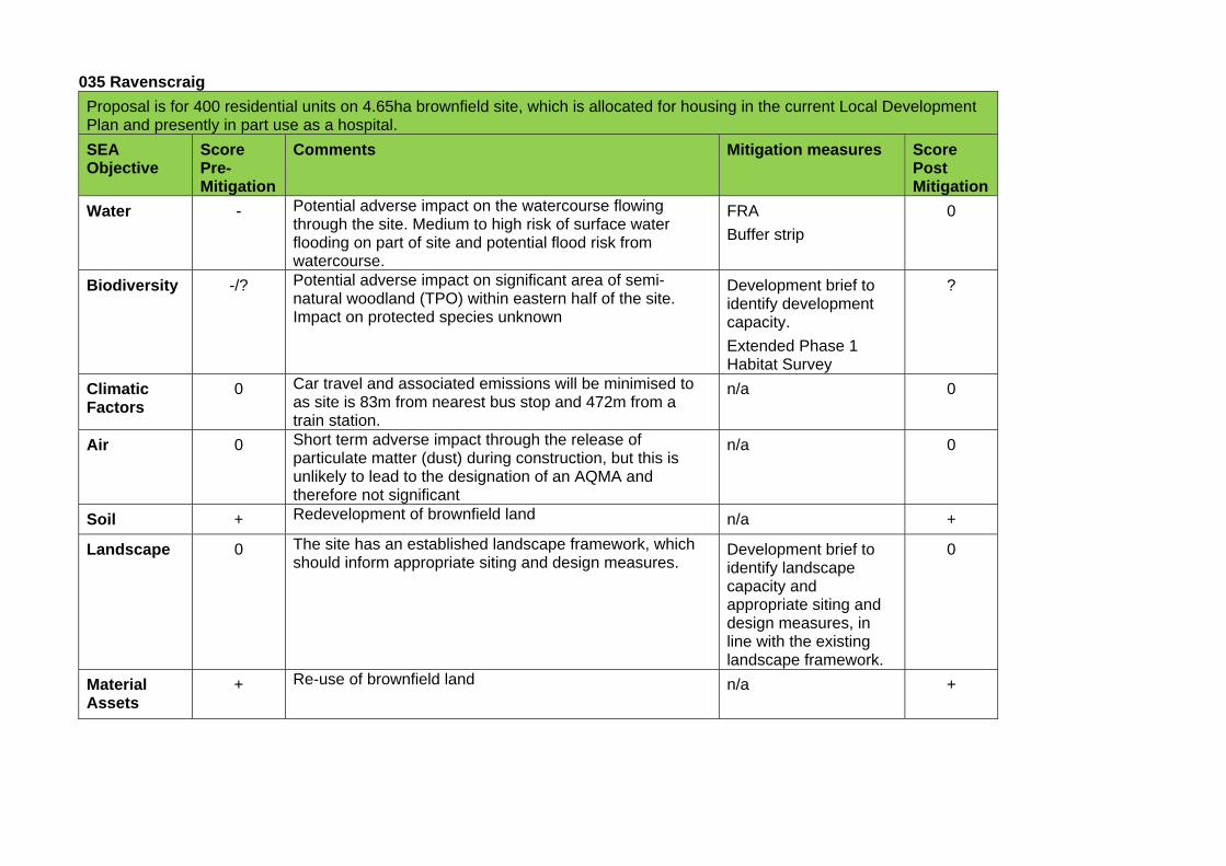
035 Ravenscraig
Proposal is for 400 residential units on 4.65ha brownfield site, which is allocated for housing in the current Local Development Plan and presently in part use as a hospital.
SEA Objective
Score Pre-Mitigation
Comments Mitigation measures Score Post Mitigation
Water - Potential adverse impact on the watercourse flowing through the site. Medium to high risk of surface water flooding on part of site and potential flood risk from watercourse.
FRA
Buffer strip
0
Biodiversity -/? Potential adverse impact on significant area of semi-natural woodland (TPO) within eastern half of the site. Impact on protected species unknown
Development brief to identify development capacity.
Extended Phase 1 Habitat Survey
?
Climatic Factors
0 Car travel and associated emissions will be minimised to as site is 83m from nearest bus stop and 472m from a train station.
n/a 0
Air 0 Short term adverse impact through the release of particulate matter (dust) during construction, but this is unlikely to lead to the designation of an AQMA and therefore not significant
n/a 0
Soil + Redevelopment of brownfield land n/a +
Landscape 0 The site has an established landscape framework, which should inform appropriate siting and design measures.
Development brief to identify landscape capacity and appropriate siting and design measures, in line with the existing landscape framework.
0
Material Assets
+ Re-use of brownfield land n/a +
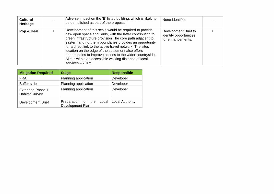
Cultural Heritage
-- Adverse impact on the ‘B’ listed building, which is likely to be demolished as part of the proposal.
None identified --
Pop & Heal + Development of this scale would be required to provide new open space and Suds, with the latter contributing to green infrastructure provision The core path adjacent to eastern and northern boundaries provides an opportunity for a direct link to the active travel network. The sites location on the edge of the settlement also offers opportunities to improve access to the wider countryside. Site is within an accessible walking distance of local services – 701m
Development Brief to identify opportunities for enhancements.
+
Mitigation Required Stage Responsible
FRA Planning application Developer
Buffer strip Planning application Developer
Extended Phase 1 Habitat Survey
Planning application Developer
Development Brief Preparation of the Local Development Plan
Local Authority
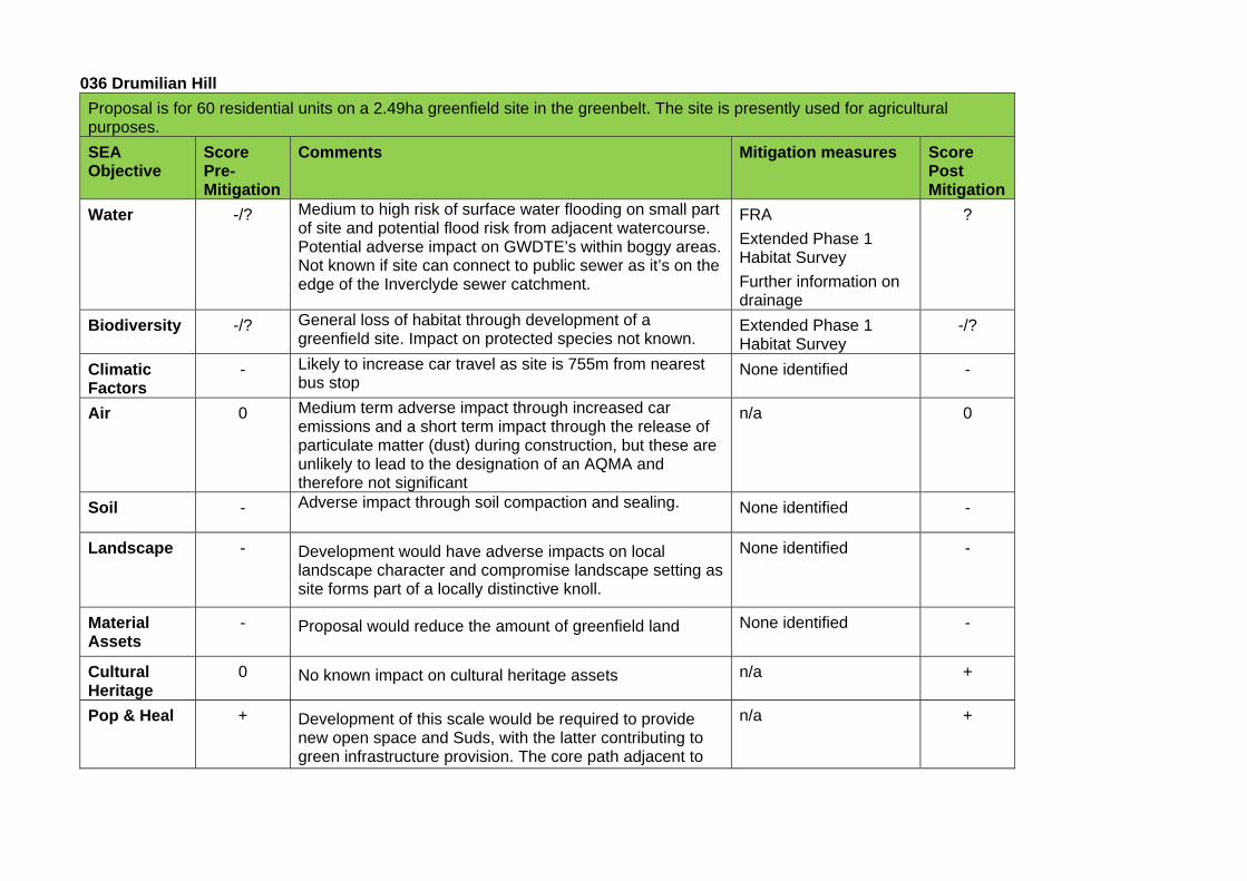
036 Drumilian Hill
Proposal is for 60 residential units on a 2.49ha greenfield site in the greenbelt. The site is presently used for agricultural purposes.
SEA Objective
Score Pre-Mitigation
Comments Mitigation measures Score Post Mitigation
Water -/? Medium to high risk of surface water flooding on small part of site and potential flood risk from adjacent watercourse. Potential adverse impact on GWDTE’s within boggy areas. Not known if site can connect to public sewer as it’s on the edge of the Inverclyde sewer catchment.
FRA
Extended Phase 1 Habitat Survey
Further information on drainage
?
Biodiversity -/? General loss of habitat through development of a greenfield site. Impact on protected species not known.
Extended Phase 1 Habitat Survey
-/?
Climatic Factors
- Likely to increase car travel as site is 755m from nearest bus stop
None identified -
Air 0 Medium term adverse impact through increased car emissions and a short term impact through the release of particulate matter (dust) during construction, but these are unlikely to lead to the designation of an AQMA and therefore not significant
n/a 0
Soil - Adverse impact through soil compaction and sealing. None identified -
Landscape - Development would have adverse impacts on local landscape character and compromise landscape setting as site forms part of a locally distinctive knoll.
None identified -
Material Assets
- Proposal would reduce the amount of greenfield land None identified -
Cultural Heritage
0 No known impact on cultural heritage assets n/a +
Pop & Heal + Development of this scale would be required to provide new open space and Suds, with the latter contributing to green infrastructure provision. The core path adjacent to
n/a +
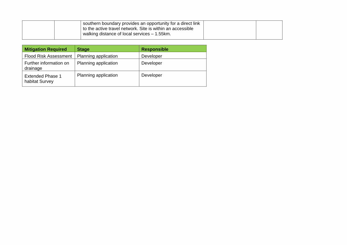
southern boundary provides an opportunity for a direct link to the active travel network. Site is within an accessible walking distance of local services – 1.55km.
Mitigation Required Stage Responsible
Flood Risk Assessment Planning application Developer
Further information on drainage
Planning application Developer
Extended Phase 1 habitat Survey
Planning application Developer
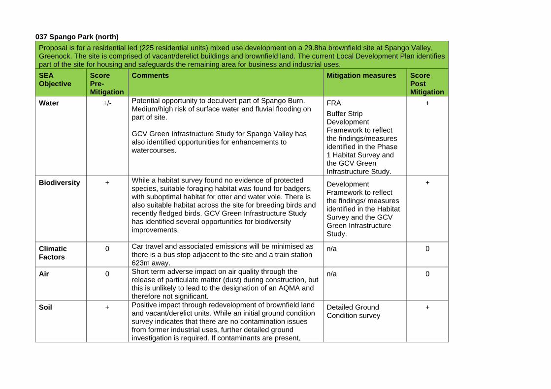
037 Spango Park (north)
Proposal is for a residential led (225 residential units) mixed use development on a 29.8ha brownfield site at Spango Valley, Greenock. The site is comprised of vacant/derelict buildings and brownfield land. The current Local Development Plan identifies part of the site for housing and safeguards the remaining area for business and industrial uses.
SEA Objective
Score Pre-Mitigation
Comments Mitigation measures Score Post Mitigation
Water +/- Potential opportunity to deculvert part of Spango Burn. Medium/high risk of surface water and fluvial flooding on part of site. GCV Green Infrastructure Study for Spango Valley has also identified opportunities for enhancements to watercourses.
FRA
Buffer Strip Development Framework to reflect the findings/measures identified in the Phase 1 Habitat Survey and the GCV Green Infrastructure Study.
+
Biodiversity + While a habitat survey found no evidence of protected species, suitable foraging habitat was found for badgers, with suboptimal habitat for otter and water vole. There is also suitable habitat across the site for breeding birds and recently fledged birds. GCV Green Infrastructure Study has identified several opportunities for biodiversity improvements.
Development Framework to reflect the findings/ measures identified in the Habitat Survey and the GCV Green Infrastructure Study.
+
Climatic Factors
0 Car travel and associated emissions will be minimised as there is a bus stop adjacent to the site and a train station 623m away.
n/a 0
Air 0 Short term adverse impact on air quality through the release of particulate matter (dust) during construction, but this is unlikely to lead to the designation of an AQMA and therefore not significant.
n/a 0
Soil + Positive impact through redevelopment of brownfield land and vacant/derelict units. While an initial ground condition survey indicates that there are no contamination issues from former industrial uses, further detailed ground investigation is required. If contaminants are present,
Detailed Ground Condition survey
+
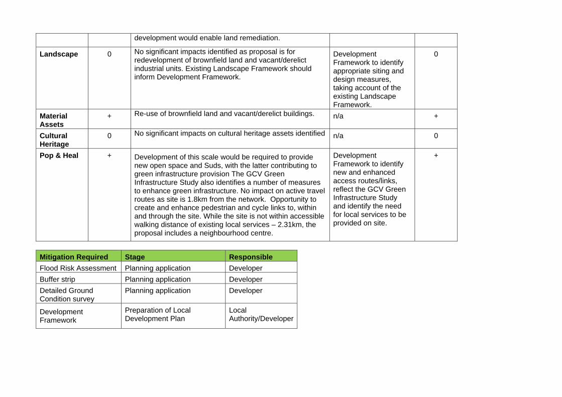
development would enable land remediation.
Landscape 0 No significant impacts identified as proposal is for redevelopment of brownfield land and vacant/derelict industrial units. Existing Landscape Framework should inform Development Framework.
Development Framework to identify appropriate siting and design measures, taking account of the existing Landscape Framework.
0
Material Assets
+ Re-use of brownfield land and vacant/derelict buildings. n/a +
Cultural Heritage
0 No significant impacts on cultural heritage assets identified n/a 0
Pop & Heal + Development of this scale would be required to provide new open space and Suds, with the latter contributing to green infrastructure provision The GCV Green Infrastructure Study also identifies a number of measures to enhance green infrastructure. No impact on active travel routes as site is 1.8km from the network. Opportunity to create and enhance pedestrian and cycle links to, within and through the site. While the site is not within accessible walking distance of existing local services – 2.31km, the proposal includes a neighbourhood centre.
Development Framework to identify new and enhanced access routes/links, reflect the GCV Green Infrastructure Study and identify the need for local services to be provided on site.
+
Mitigation Required Stage Responsible
Flood Risk Assessment Planning application Developer
Buffer strip Planning application Developer
Detailed Ground Condition survey
Planning application Developer
Development Framework
Preparation of Local Development Plan
Local Authority/Developer
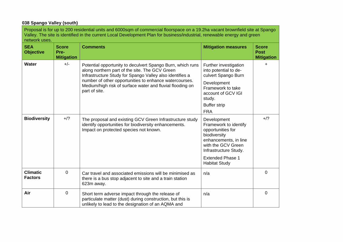
038 Spango Valley (south)
Proposal is for up to 200 residential units and 6000sqm of commercial floorspace on a 19.2ha vacant brownfield site at Spango Valley. The site is identified in the current Local Development Plan for business/industrial, renewable energy and green network uses.
SEA Objective
Score Pre-Mitigation
Comments Mitigation measures Score Post Mitigation
Water +/- Potential opportunity to deculvert Spango Burn, which runs along northern part of the site. The GCV Green Infrastructure Study for Spango Valley also identifies a number of other opportunities to enhance watercourses. Medium/high risk of surface water and fluvial flooding on part of site.
Further investigation into potential to de-culvert Spango Burn
Development Framework to take account of GCV IGI study.
Buffer strip
FRA
+
Biodiversity +/? The proposal and existing GCV Green Infrastructure study identify opportunities for biodiversity enhancements. Impact on protected species not known.
Development Framework to identify opportunities for biodiversity enhancements, in line with the GCV Green Infrastructure Study.
Extended Phase 1 Habitat Study
+/?
Climatic Factors
0 Car travel and associated emissions will be minimised as there is a bus stop adjacent to site and a train station 623m away.
n/a 0
Air 0 Short term adverse impact through the release of particulate matter (dust) during construction, but this is unlikely to lead to the designation of an AQMA and
n/a 0
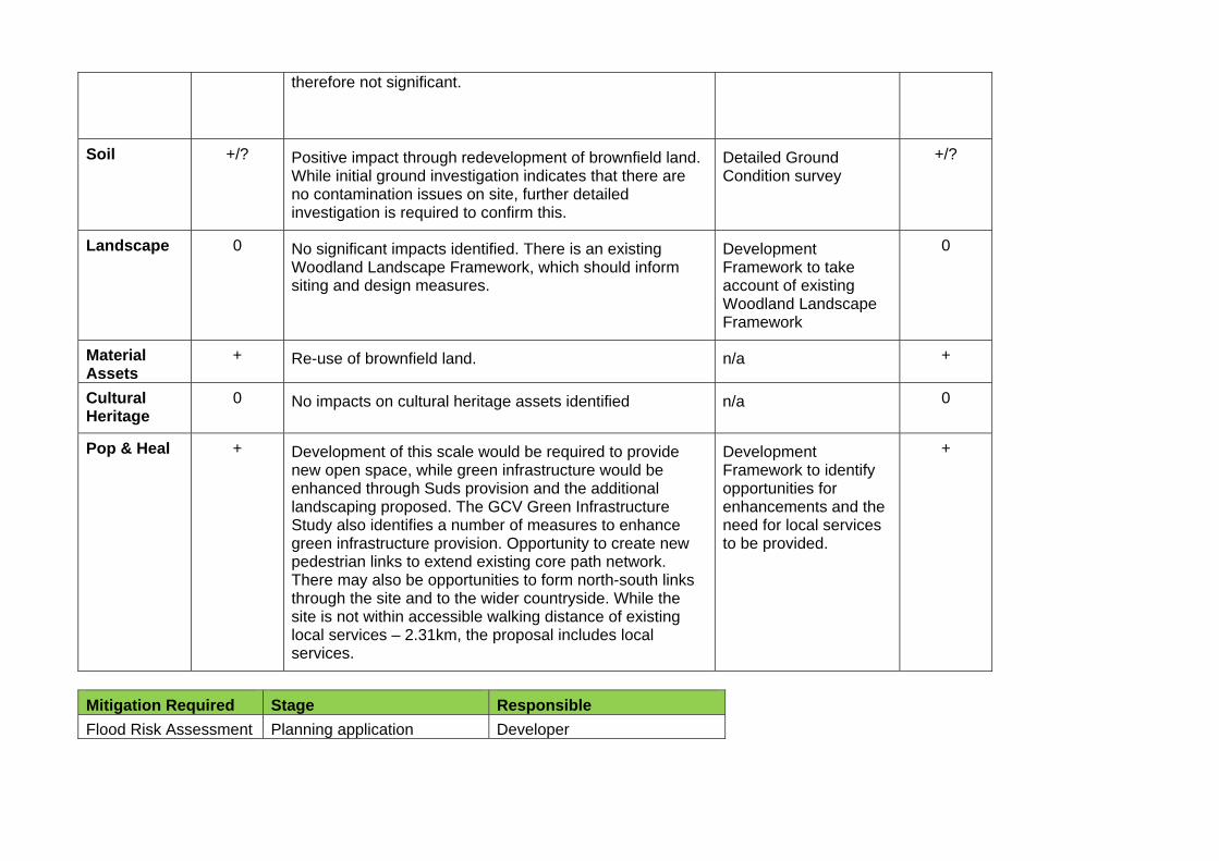
therefore not significant.
Soil +/? Positive impact through redevelopment of brownfield land. While initial ground investigation indicates that there are no contamination issues on site, further detailed investigation is required to confirm this.
Detailed Ground Condition survey
+/?
Landscape 0 No significant impacts identified. There is an existing Woodland Landscape Framework, which should inform siting and design measures.
Development Framework to take account of existing Woodland Landscape Framework
0
Material Assets
+ Re-use of brownfield land. n/a +
Cultural Heritage
0 No impacts on cultural heritage assets identified n/a 0
Pop & Heal + Development of this scale would be required to provide new open space, while green infrastructure would be enhanced through Suds provision and the additional landscaping proposed. The GCV Green Infrastructure Study also identifies a number of measures to enhance green infrastructure provision. Opportunity to create new pedestrian links to extend existing core path network. There may also be opportunities to form north-south links through the site and to the wider countryside. While the site is not within accessible walking distance of existing local services – 2.31km, the proposal includes local services.
Development Framework to identify opportunities for enhancements and the need for local services to be provided.
+
Mitigation Required Stage Responsible
Flood Risk Assessment Planning application Developer
Buffer strip Planning application Developer
Development Framework
Preparation of Local Development Plan
Developer
Extended Phase 1 Habitat Survey
Planning application Developer
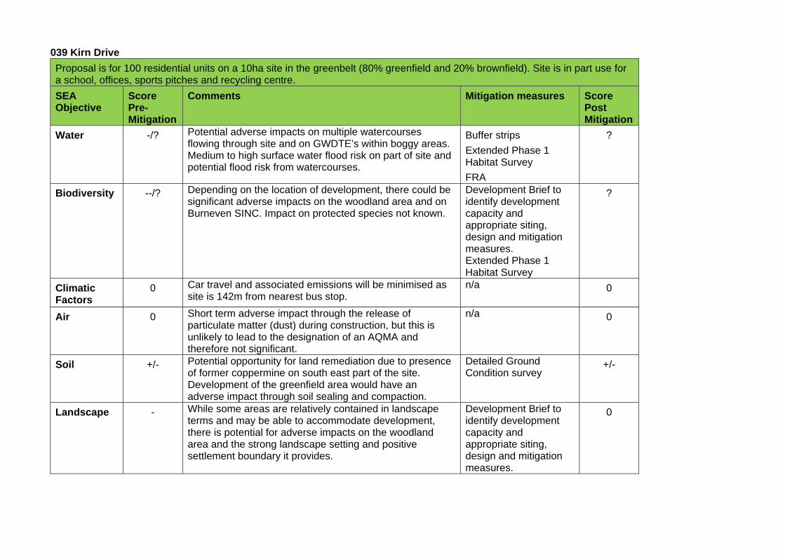
039 Kirn Drive
Proposal is for 100 residential units on a 10ha site in the greenbelt (80% greenfield and 20% brownfield). Site is in part use for a school, offices, sports pitches and recycling centre.
SEA Objective
Score Pre-Mitigation
Comments Mitigation measures Score Post Mitigation
Water -/? Potential adverse impacts on multiple watercourses flowing through site and on GWDTE’s within boggy areas. Medium to high surface water flood risk on part of site and potential flood risk from watercourses.
Buffer strips
Extended Phase 1 Habitat Survey
FRA
?
Biodiversity --/? Depending on the location of development, there could be significant adverse impacts on the woodland area and on Burneven SINC. Impact on protected species not known.
Development Brief to identify development capacity and appropriate siting, design and mitigation measures. Extended Phase 1 Habitat Survey
?
Climatic Factors
0 Car travel and associated emissions will be minimised as site is 142m from nearest bus stop.
n/a 0
Air 0 Short term adverse impact through the release of particulate matter (dust) during construction, but this is unlikely to lead to the designation of an AQMA and therefore not significant.
n/a 0
Soil +/- Potential opportunity for land remediation due to presence of former coppermine on south east part of the site. Development of the greenfield area would have an adverse impact through soil sealing and compaction.
Detailed Ground Condition survey
+/-
Landscape - While some areas are relatively contained in landscape terms and may be able to accommodate development, there is potential for adverse impacts on the woodland area and the strong landscape setting and positive settlement boundary it provides.
Development Brief to identify development capacity and appropriate siting, design and mitigation measures.
0
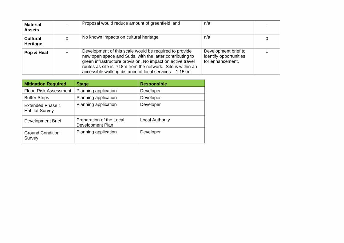
Material Assets
- Proposal would reduce amount of greenfield land n/a -
Cultural Heritage
0 No known impacts on cultural heritage n/a 0
Pop & Heal + Development of this scale would be required to provide new open space and Suds, with the latter contributing to green infrastructure provision. No impact on active travel routes as site is. 718m from the network. Site is within an accessible walking distance of local services – 1.15km.
Development brief to identify opportunities for enhancement.
+
Mitigation Required Stage Responsible
Flood Risk Assessment Planning application Developer
Buffer Strips Planning application Developer
Extended Phase 1 Habitat Survey
Planning application Developer
Development Brief Preparation of the Local Development Plan
Local Authority
Ground Condition Survey
Planning application Developer
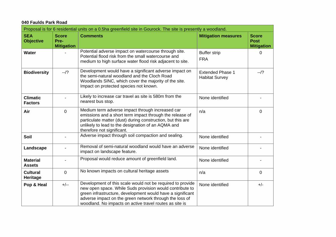
040 Faulds Park Road
Proposal is for 6 residential units on a 0.5ha greenfield site in Gourock. The site is presently a woodland.
SEA Objective
Score Pre-Mitigation
Comments Mitigation measures Score Post Mitigation
Water - Potential adverse impact on watercourse through site. Potential flood risk from the small watercourse and medium to high surface water flood risk adjacent to site.
Buffer strip
FRA
0
Biodiversity --/? Development would have a significant adverse impact on the semi-natural woodland and the Cloch Road Woodlands SINC, which cover the majority of the site. Impact on protected species not known.
Extended Phase 1 Habitat Survey
--/?
Climatic Factors
- Likely to increase car travel as site is 580m from the nearest bus stop.
None identified -
Air 0 Medium term adverse impact through increased car emissions and a short term impact through the release of particulate matter (dust) during construction, but this are unlikely to lead to the designation of an AQMA and therefore not significant.
n/a 0
Soil - Adverse impact through soil compaction and sealing. None identified -
Landscape - Removal of semi-natural woodland would have an adverse impact on landscape feature.
None identified -
Material Assets
- Proposal would reduce amount of greenfield land. None identified -
Cultural Heritage
0 No known impacts on cultural heritage assets n/a 0
Pop & Heal +/-- Development of this scale would not be required to provide new open space. While Suds provision would contribute to green infrastructure, development would have a significant adverse impact on the green network through the loss of woodland. No impacts on active travel routes as site is
None identified +/-
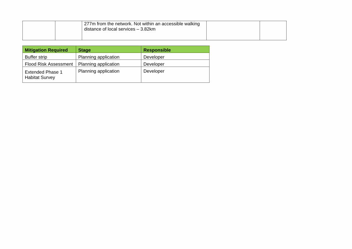
277m from the network. Not within an accessible walking distance of local services – 3.82km
Mitigation Required Stage Responsible
Buffer strip Planning application Developer
Flood Risk Assessment Planning application Developer
Extended Phase 1 Habitat Survey
Planning application Developer
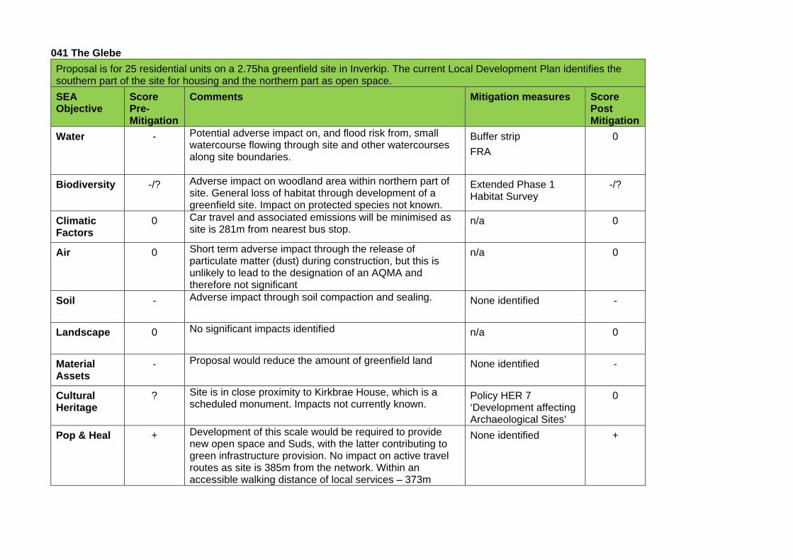
041 The Glebe
Proposal is for 25 residential units on a 2.75ha greenfield site in Inverkip. The current Local Development Plan identifies the southern part of the site for housing and the northern part as open space.
SEA Objective
Score Pre-Mitigation
Comments Mitigation measures Score Post Mitigation
Water - Potential adverse impact on, and flood risk from, small watercourse flowing through site and other watercourses along site boundaries.
Buffer strip
FRA
0
Biodiversity -/? Adverse impact on woodland area within northern part of site. General loss of habitat through development of a greenfield site. Impact on protected species not known.
Extended Phase 1 Habitat Survey
-/?
Climatic Factors
0 Car travel and associated emissions will be minimised as site is 281m from nearest bus stop.
n/a 0
Air 0 Short term adverse impact through the release of particulate matter (dust) during construction, but this is unlikely to lead to the designation of an AQMA and therefore not significant
n/a 0
Soil - Adverse impact through soil compaction and sealing. None identified -
Landscape 0 No significant impacts identified n/a 0
Material Assets
- Proposal would reduce the amount of greenfield land None identified -
Cultural Heritage
? Site is in close proximity to Kirkbrae House, which is a scheduled monument. Impacts not currently known.
Policy HER 7 ‘Development affecting Archaeological Sites’
0
Pop & Heal + Development of this scale would be required to provide new open space and Suds, with the latter contributing to green infrastructure provision. No impact on active travel routes as site is 385m from the network. Within an accessible walking distance of local services – 373m
None identified +
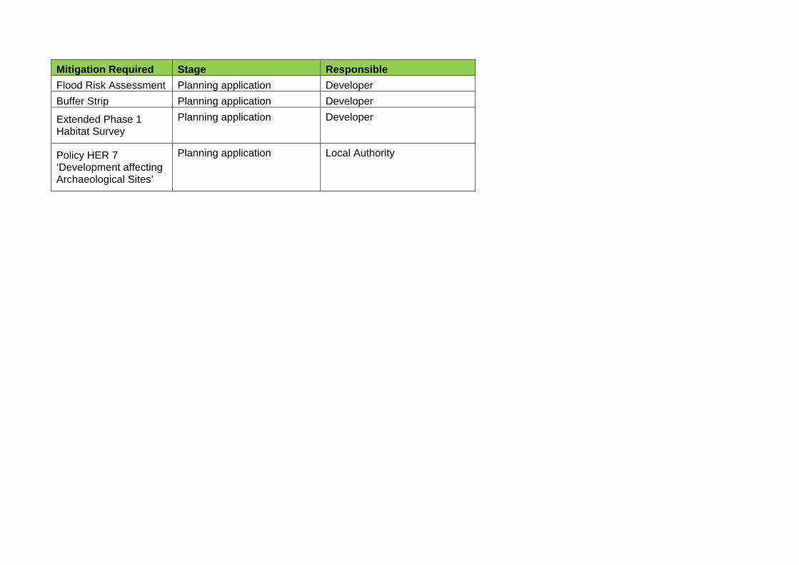
Mitigation Required Stage Responsible
Flood Risk Assessment Planning application Developer
Buffer Strip Planning application Developer
Extended Phase 1 Habitat Survey
Planning application Developer
Policy HER 7 ‘Development affecting Archaeological Sites’
Planning application Local Authority
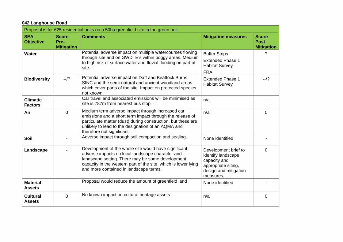
042 Langhouse Road
Proposal is for 625 residential units on a 50ha greenfield site in the green belt.
SEA Objective
Score Pre-Mitigation
Comments Mitigation measures Score Post Mitigation
Water - Potential adverse impact on multiple watercourses flowing through site and on GWDTE’s within boggy areas. Medium to high risk of surface water and fluvial flooding on part of site.
Buffer Strips
Extended Phase 1 Habitat Survey
FRA
?
Biodiversity --/? Potential adverse impact on Daff and Beattock Burns SINC and the semi-natural and ancient woodland areas which cover parts of the site. Impact on protected species not known.
Extended Phase 1 Habitat Survey
--/?
Climatic Factors
- Car travel and associated emissions will be minimised as site is 787m from nearest bus stop.
n/a -
Air 0 Medium term adverse impact through increased car emissions and a short term impact through the release of particulate matter (dust) during construction, but these are unlikely to lead to the designation of an AQMA and therefore not significant
n/a 0
Soil - Adverse impact through soil compaction and sealing. None identified -
Landscape - Development of the whole site would have significant adverse impacts on local landscape character and landscape setting. There may be some development capacity in the western part of the site, which is lower lying and more contained in landscape terms.
Development brief to identify landscape capacity and appropriate siting, design and mitigation measures.
0
Material Assets
- Proposal would reduce the amount of greenfield land None identified -
Cultural Assets
0 No known impact on cultural heritage assets n/a 0
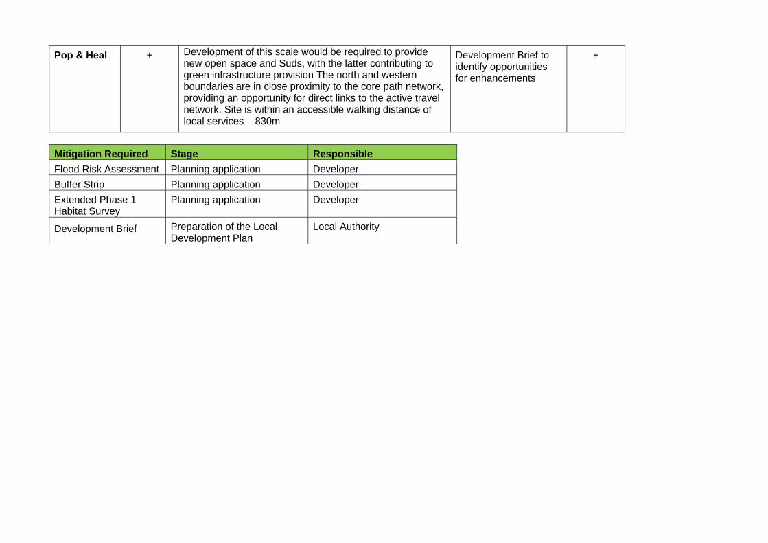
Pop & Heal + Development of this scale would be required to provide new open space and Suds, with the latter contributing to green infrastructure provision The north and western boundaries are in close proximity to the core path network, providing an opportunity for direct links to the active travel network. Site is within an accessible walking distance of local services – 830m
Development Brief to identify opportunities for enhancements
+
Mitigation Required Stage Responsible
Flood Risk Assessment Planning application Developer
Buffer Strip Planning application Developer
Extended Phase 1 Habitat Survey
Planning application Developer
Development Brief Preparation of the Local Development Plan
Local Authority
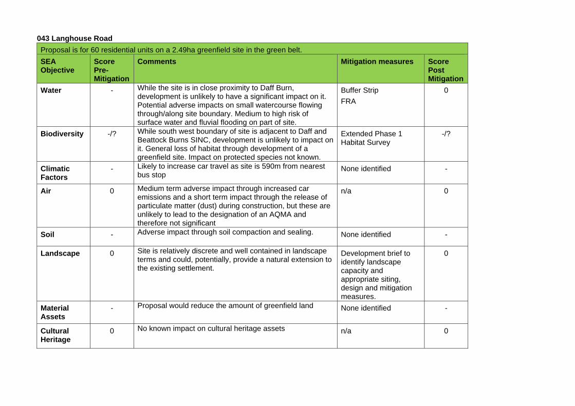
043 Langhouse Road
Proposal is for 60 residential units on a 2.49ha greenfield site in the green belt.
SEA Objective
Score Pre-Mitigation
Comments Mitigation measures Score Post Mitigation
Water - While the site is in close proximity to Daff Burn, development is unlikely to have a significant impact on it. Potential adverse impacts on small watercourse flowing through/along site boundary. Medium to high risk of surface water and fluvial flooding on part of site.
Buffer Strip
FRA
0
Biodiversity -/? While south west boundary of site is adjacent to Daff and Beattock Burns SINC, development is unlikely to impact on it. General loss of habitat through development of a greenfield site. Impact on protected species not known.
Extended Phase 1 Habitat Survey
-/?
Climatic Factors
- Likely to increase car travel as site is 590m from nearest bus stop
None identified -
Air 0 Medium term adverse impact through increased car emissions and a short term impact through the release of particulate matter (dust) during construction, but these are unlikely to lead to the designation of an AQMA and therefore not significant
n/a 0
Soil - Adverse impact through soil compaction and sealing. None identified -
Landscape 0 Site is relatively discrete and well contained in landscape terms and could, potentially, provide a natural extension to the existing settlement.
Development brief to identify landscape capacity and appropriate siting, design and mitigation measures.
0
Material Assets
- Proposal would reduce the amount of greenfield land None identified -
Cultural Heritage
0 No known impact on cultural heritage assets n/a 0
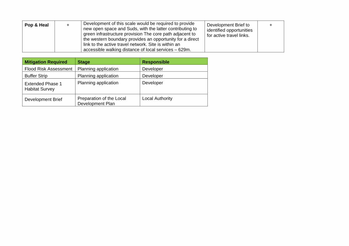
Pop & Heal + Development of this scale would be required to provide new open space and Suds, with the latter contributing to green infrastructure provision The core path adjacent to the western boundary provides an opportunity for a direct link to the active travel network. Site is within an accessible walking distance of local services – 629m.
Development Brief to identified opportunities for active travel links.
+
Mitigation Required Stage Responsible
Flood Risk Assessment Planning application Developer
Buffer Strip Planning application Developer
Extended Phase 1 Habitat Survey
Planning application Developer
Development Brief Preparation of the Local Development Plan
Local Authority
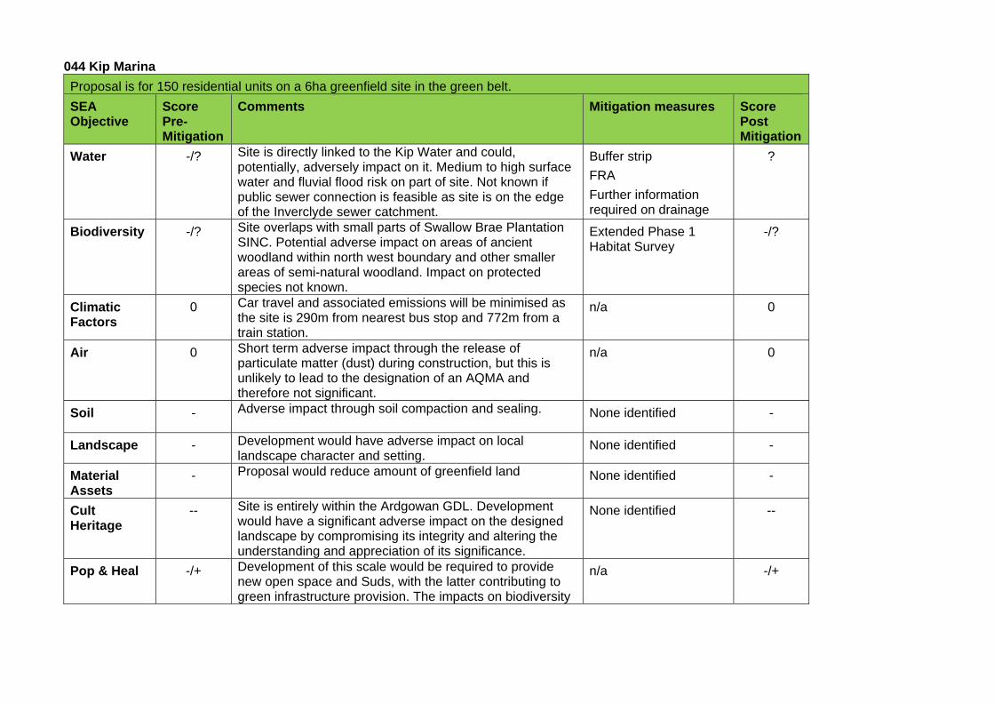
044 Kip Marina
Proposal is for 150 residential units on a 6ha greenfield site in the green belt.
SEA Objective
Score Pre-Mitigation
Comments Mitigation measures Score Post Mitigation
Water -/? Site is directly linked to the Kip Water and could, potentially, adversely impact on it. Medium to high surface water and fluvial flood risk on part of site. Not known if public sewer connection is feasible as site is on the edge of the Inverclyde sewer catchment.
Buffer strip
FRA
Further information required on drainage
?
Biodiversity -/? Site overlaps with small parts of Swallow Brae Plantation SINC. Potential adverse impact on areas of ancient woodland within north west boundary and other smaller areas of semi-natural woodland. Impact on protected species not known.
Extended Phase 1 Habitat Survey
-/?
Climatic Factors
0 Car travel and associated emissions will be minimised as the site is 290m from nearest bus stop and 772m from a train station.
n/a 0
Air 0 Short term adverse impact through the release of particulate matter (dust) during construction, but this is unlikely to lead to the designation of an AQMA and therefore not significant.
n/a 0
Soil - Adverse impact through soil compaction and sealing. None identified -
Landscape - Development would have adverse impact on local landscape character and setting.
None identified -
Material Assets
- Proposal would reduce amount of greenfield land None identified -
Cult Heritage
-- Site is entirely within the Ardgowan GDL. Development would have a significant adverse impact on the designed landscape by compromising its integrity and altering the understanding and appreciation of its significance.
None identified --
Pop & Heal -/+ Development of this scale would be required to provide new open space and Suds, with the latter contributing to green infrastructure provision. The impacts on biodiversity
n/a -/+
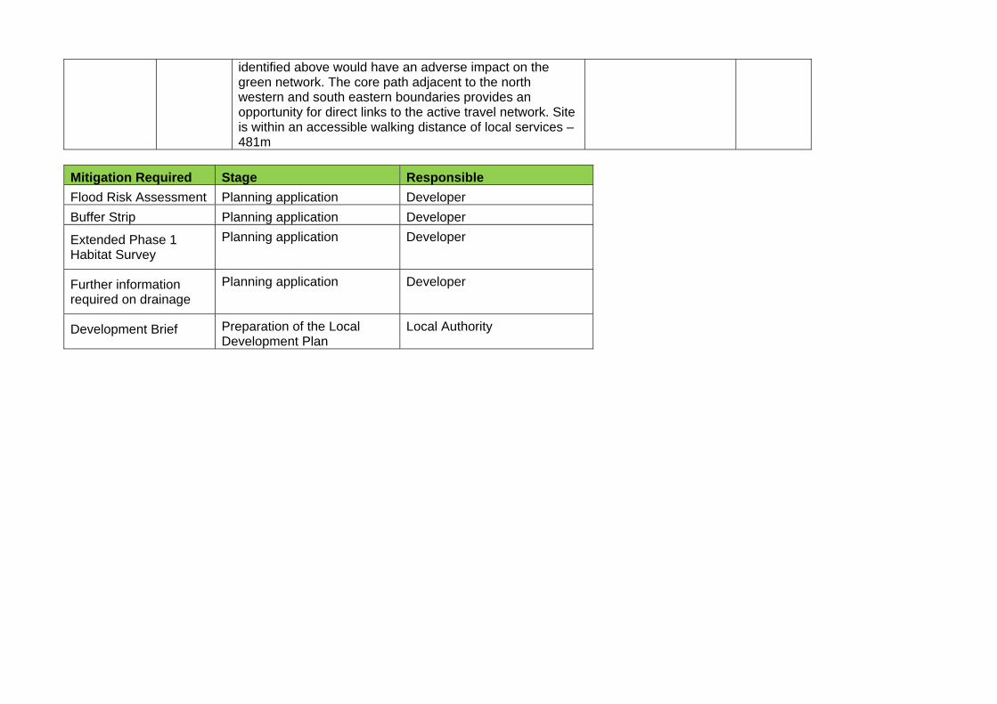
identified above would have an adverse impact on the green network. The core path adjacent to the north western and south eastern boundaries provides an opportunity for direct links to the active travel network. Site is within an accessible walking distance of local services – 481m
Mitigation Required Stage Responsible
Flood Risk Assessment Planning application Developer
Buffer Strip Planning application Developer
Extended Phase 1 Habitat Survey
Planning application Developer
Further information required on drainage
Planning application Developer
Development Brief Preparation of the Local Development Plan
Local Authority
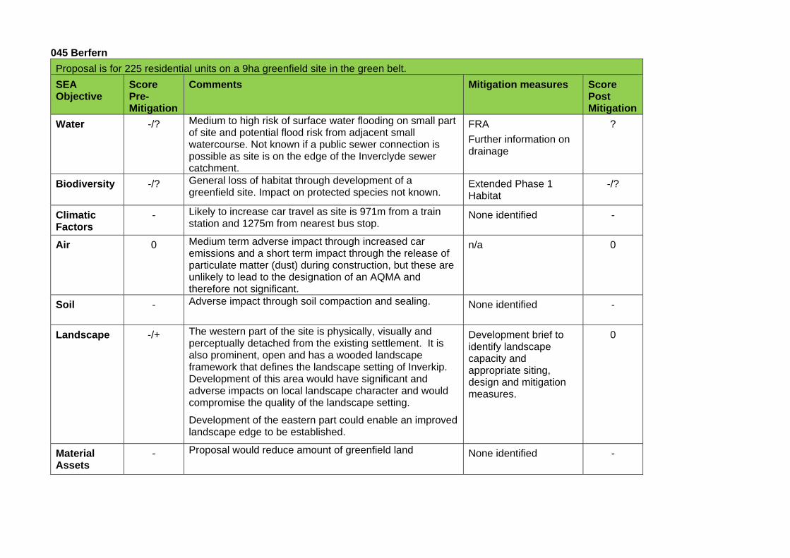
045 Berfern
Proposal is for 225 residential units on a 9ha greenfield site in the green belt.
SEA Objective
Score Pre-Mitigation
Comments Mitigation measures Score Post Mitigation
Water -/? Medium to high risk of surface water flooding on small part of site and potential flood risk from adjacent small watercourse. Not known if a public sewer connection is possible as site is on the edge of the Inverclyde sewer catchment.
FRA
Further information on drainage
?
Biodiversity -/? General loss of habitat through development of a greenfield site. Impact on protected species not known.
Extended Phase 1 Habitat
-/?
Climatic Factors
- Likely to increase car travel as site is 971m from a train station and 1275m from nearest bus stop.
None identified -
Air 0 Medium term adverse impact through increased car emissions and a short term impact through the release of particulate matter (dust) during construction, but these are unlikely to lead to the designation of an AQMA and therefore not significant.
n/a 0
Soil - Adverse impact through soil compaction and sealing. None identified -
Landscape -/+ The western part of the site is physically, visually and perceptually detached from the existing settlement. It is also prominent, open and has a wooded landscape framework that defines the landscape setting of Inverkip. Development of this area would have significant and adverse impacts on local landscape character and would compromise the quality of the landscape setting.
Development of the eastern part could enable an improved landscape edge to be established.
Development brief to identify landscape capacity and appropriate siting, design and mitigation measures.
0
Material Assets
- Proposal would reduce amount of greenfield land None identified -
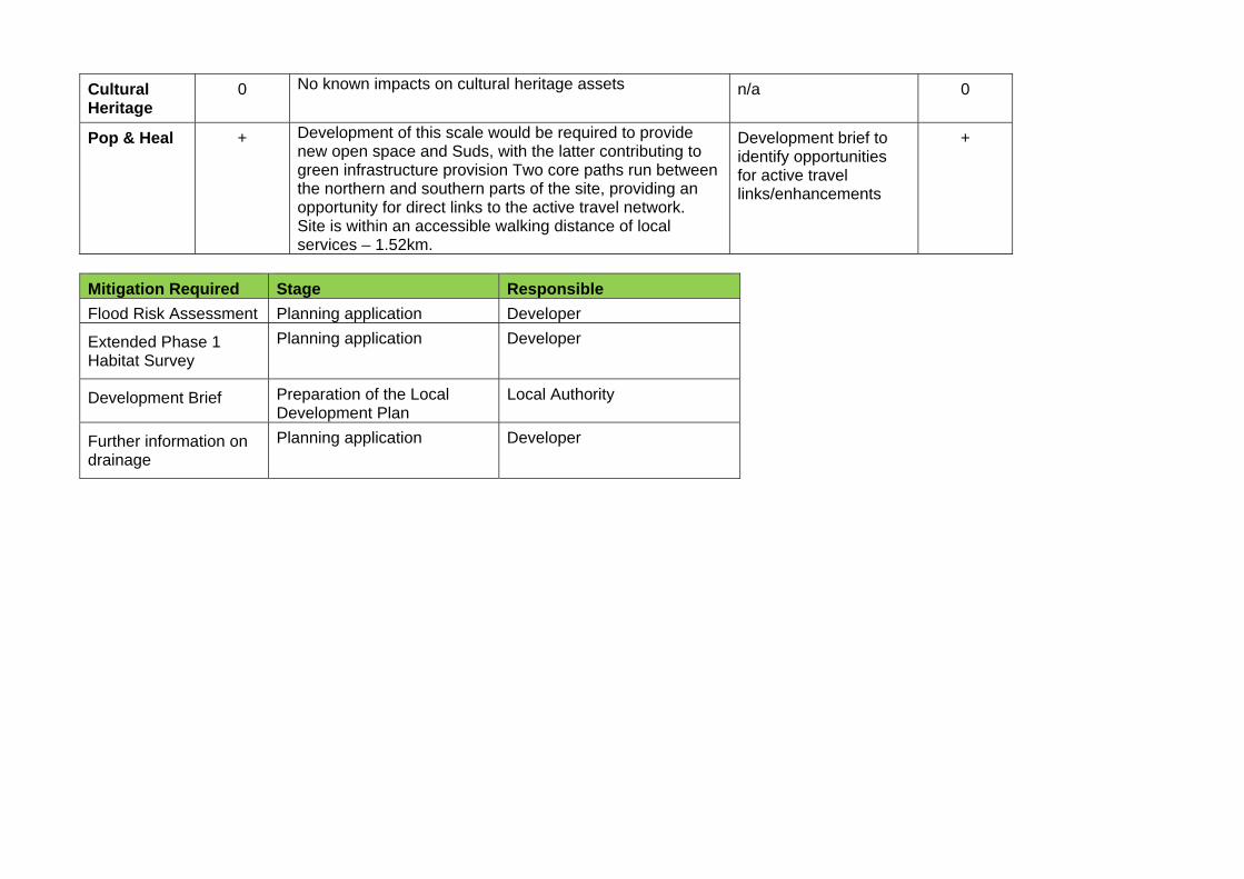
Cultural Heritage
0 No known impacts on cultural heritage assets n/a 0
Pop & Heal + Development of this scale would be required to provide new open space and Suds, with the latter contributing to green infrastructure provision Two core paths run between the northern and southern parts of the site, providing an opportunity for direct links to the active travel network. Site is within an accessible walking distance of local services – 1.52km.
Development brief to identify opportunities for active travel links/enhancements
+
Mitigation Required Stage Responsible
Flood Risk Assessment Planning application Developer
Extended Phase 1 Habitat Survey
Planning application Developer
Development Brief Preparation of the Local Development Plan
Local Authority
Further information on drainage
Planning application Developer
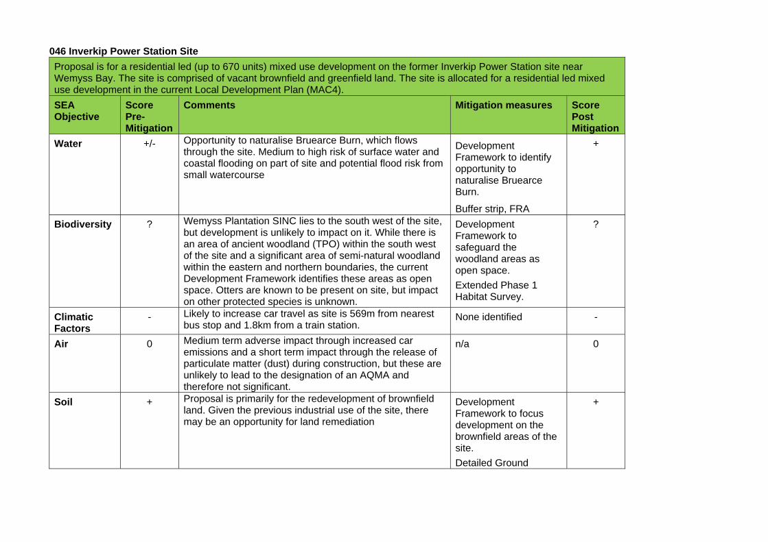
046 Inverkip Power Station Site
Proposal is for a residential led (up to 670 units) mixed use development on the former Inverkip Power Station site near Wemyss Bay. The site is comprised of vacant brownfield and greenfield land. The site is allocated for a residential led mixed use development in the current Local Development Plan (MAC4).
SEA Objective
Score Pre-Mitigation
Comments Mitigation measures Score Post Mitigation
Water +/- Opportunity to naturalise Bruearce Burn, which flows through the site. Medium to high risk of surface water and coastal flooding on part of site and potential flood risk from small watercourse
Development Framework to identify opportunity to naturalise Bruearce Burn.
Buffer strip, FRA
+
Biodiversity ? Wemyss Plantation SINC lies to the south west of the site, but development is unlikely to impact on it. While there is an area of ancient woodland (TPO) within the south west of the site and a significant area of semi-natural woodland within the eastern and northern boundaries, the current Development Framework identifies these areas as open space. Otters are known to be present on site, but impact on other protected species is unknown.
Development Framework to safeguard the woodland areas as open space.
Extended Phase 1 Habitat Survey.
?
Climatic Factors
- Likely to increase car travel as site is 569m from nearest bus stop and 1.8km from a train station.
None identified -
Air 0 Medium term adverse impact through increased car emissions and a short term impact through the release of particulate matter (dust) during construction, but these are unlikely to lead to the designation of an AQMA and therefore not significant.
n/a 0
Soil + Proposal is primarily for the redevelopment of brownfield land. Given the previous industrial use of the site, there may be an opportunity for land remediation
Development Framework to focus development on the brownfield areas of the site.
Detailed Ground
+
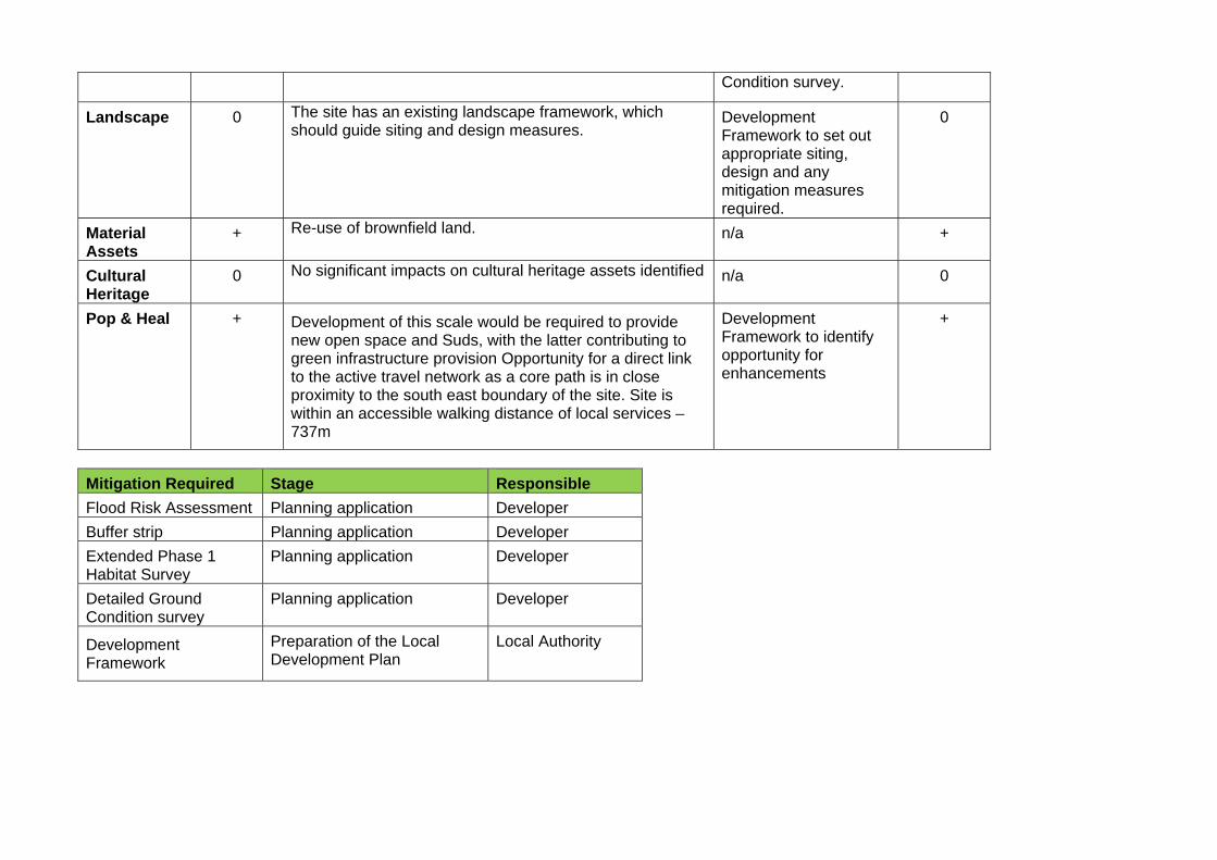
Condition survey.
Landscape 0 The site has an existing landscape framework, which should guide siting and design measures.
Development Framework to set out appropriate siting, design and any mitigation measures required.
0
Material Assets
+ Re-use of brownfield land. n/a +
Cultural Heritage
0 No significant impacts on cultural heritage assets identified n/a 0
Pop & Heal + Development of this scale would be required to provide new open space and Suds, with the latter contributing to green infrastructure provision Opportunity for a direct link to the active travel network as a core path is in close proximity to the south east boundary of the site. Site is within an accessible walking distance of local services – 737m
Development Framework to identify opportunity for enhancements
+
Mitigation Required Stage Responsible
Flood Risk Assessment Planning application Developer
Buffer strip Planning application Developer
Extended Phase 1 Habitat Survey
Planning application Developer
Detailed Ground Condition survey
Planning application Developer
Development Framework
Preparation of the Local Development Plan
Local Authority
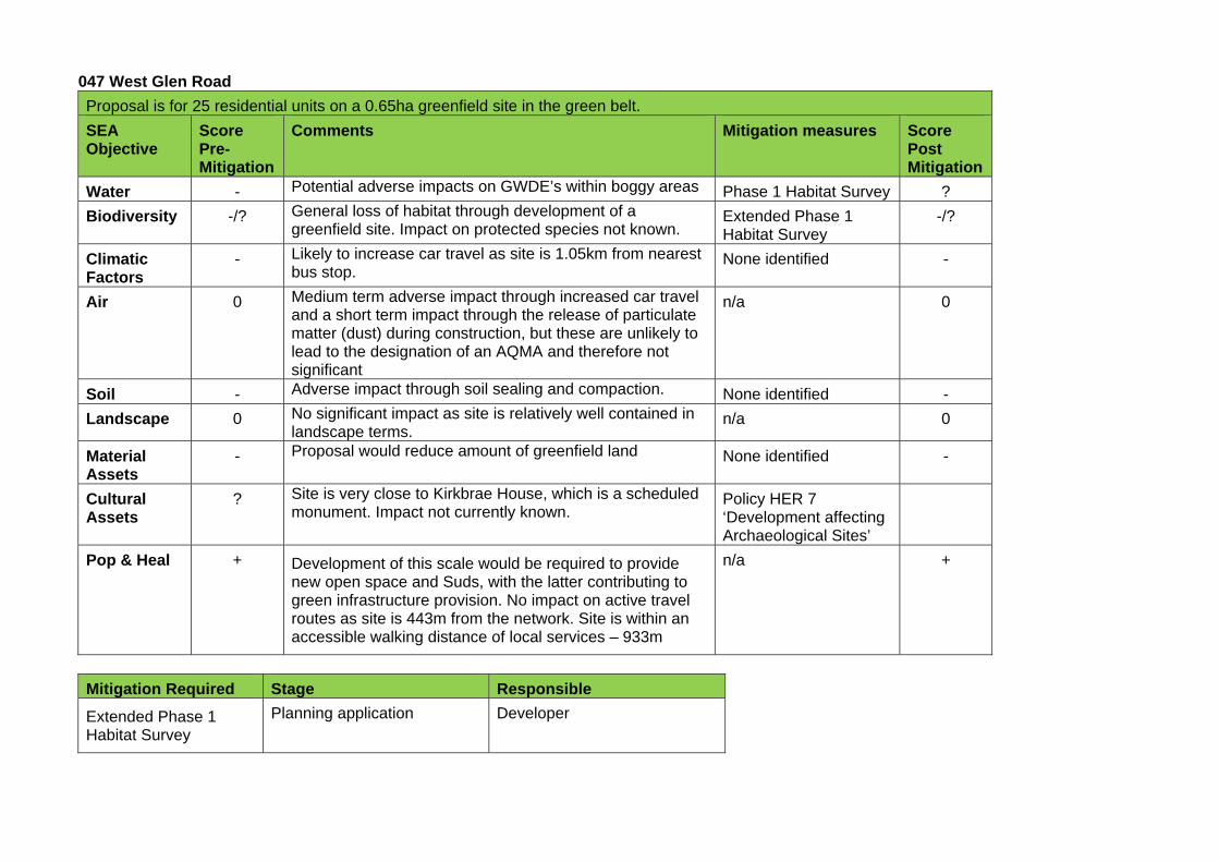
047 West Glen Road
Proposal is for 25 residential units on a 0.65ha greenfield site in the green belt.
SEA Objective
Score Pre-Mitigation
Comments Mitigation measures Score Post Mitigation
Water - Potential adverse impacts on GWDE’s within boggy areas Phase 1 Habitat Survey ?
Biodiversity -/? General loss of habitat through development of a greenfield site. Impact on protected species not known.
Extended Phase 1 Habitat Survey
-/?
Climatic Factors
- Likely to increase car travel as site is 1.05km from nearest bus stop.
None identified -
Air 0 Medium term adverse impact through increased car travel and a short term impact through the release of particulate matter (dust) during construction, but these are unlikely to lead to the designation of an AQMA and therefore not significant
n/a 0
Soil - Adverse impact through soil sealing and compaction. None identified -
Landscape 0 No significant impact as site is relatively well contained in landscape terms.
n/a 0
Material Assets
- Proposal would reduce amount of greenfield land None identified -
Cultural Assets
? Site is very close to Kirkbrae House, which is a scheduled monument. Impact not currently known.
Policy HER 7 ‘Development affecting Archaeological Sites’
Pop & Heal + Development of this scale would be required to provide new open space and Suds, with the latter contributing to green infrastructure provision. No impact on active travel routes as site is 443m from the network. Site is within an accessible walking distance of local services – 933m
n/a +
Mitigation Required Stage Responsible
Extended Phase 1 Habitat Survey
Planning application Developer
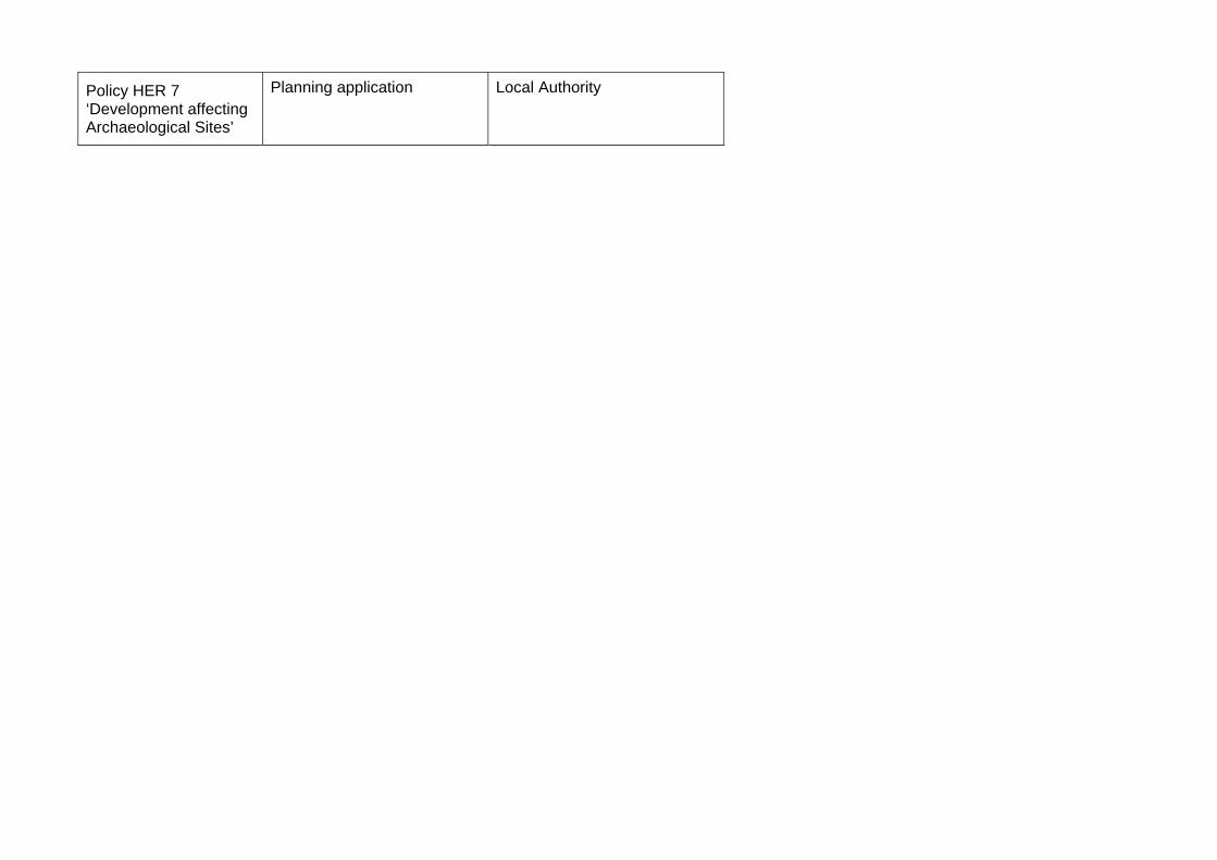
Policy HER 7 ‘Development affecting Archaeological Sites’
Planning application Local Authority
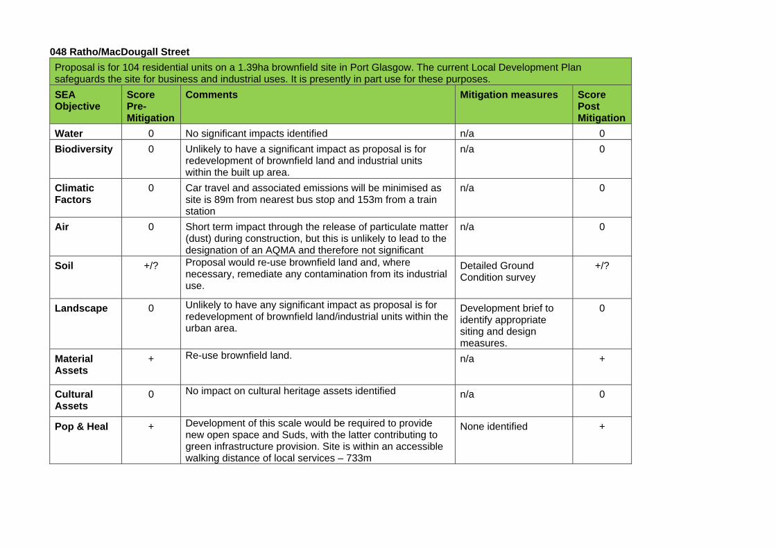
048 Ratho/MacDougall Street
Proposal is for 104 residential units on a 1.39ha brownfield site in Port Glasgow. The current Local Development Plan safeguards the site for business and industrial uses. It is presently in part use for these purposes.
SEA Objective
Score Pre-Mitigation
Comments Mitigation measures Score Post Mitigation
Water 0 No significant impacts identified n/a 0
Biodiversity 0 Unlikely to have a significant impact as proposal is for redevelopment of brownfield land and industrial units within the built up area.
n/a 0
Climatic Factors
0 Car travel and associated emissions will be minimised as site is 89m from nearest bus stop and 153m from a train station
n/a 0
Air 0 Short term impact through the release of particulate matter (dust) during construction, but this is unlikely to lead to the designation of an AQMA and therefore not significant
n/a 0
Soil +/? Proposal would re-use brownfield land and, where necessary, remediate any contamination from its industrial use.
Detailed Ground Condition survey
+/?
Landscape 0 Unlikely to have any significant impact as proposal is for redevelopment of brownfield land/industrial units within the urban area.
Development brief to identify appropriate siting and design measures.
0
Material Assets
+ Re-use brownfield land. n/a +
Cultural Assets
0 No impact on cultural heritage assets identified n/a 0
Pop & Heal + Development of this scale would be required to provide new open space and Suds, with the latter contributing to green infrastructure provision. Site is within an accessible walking distance of local services – 733m
None identified +
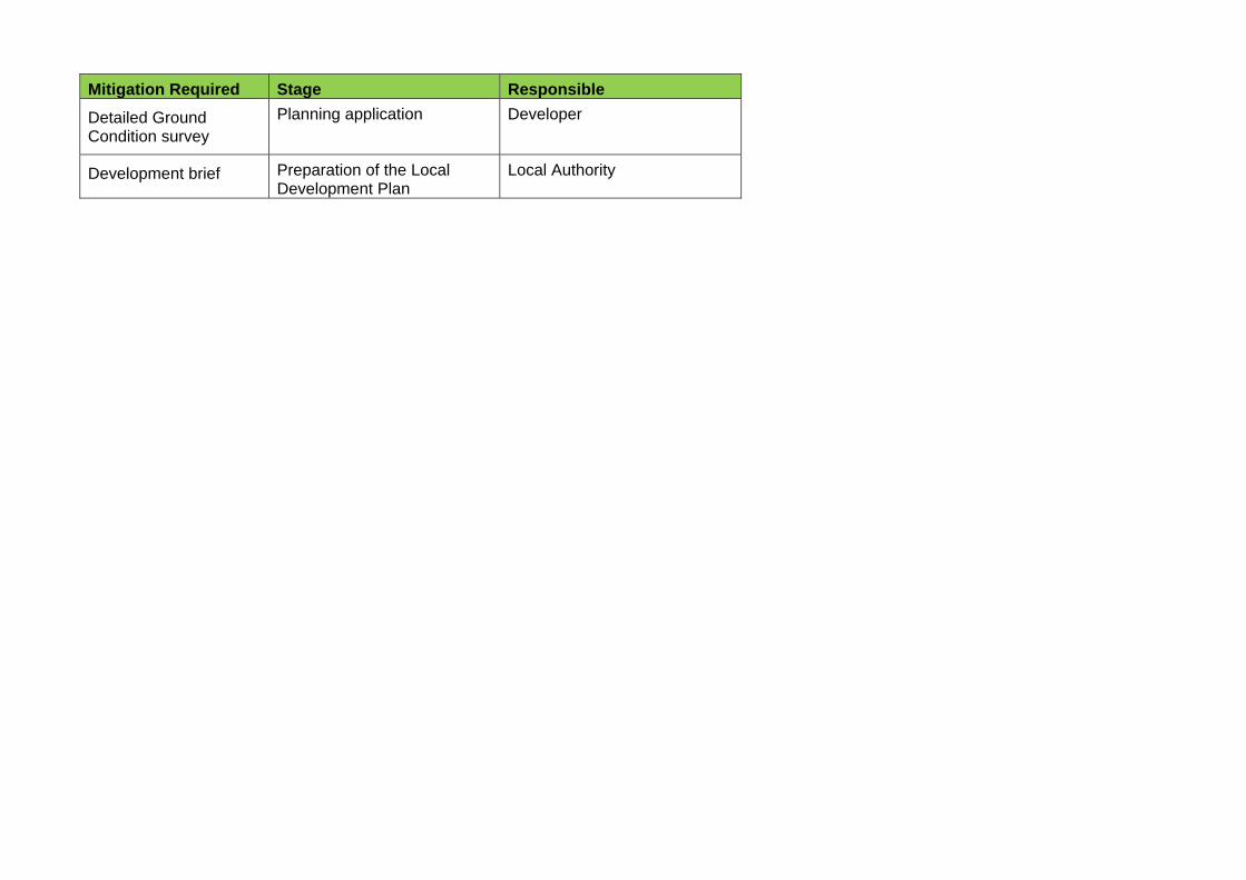
Mitigation Required Stage Responsible
Detailed Ground Condition survey
Planning application Developer
Development brief Preparation of the Local Development Plan
Local Authority
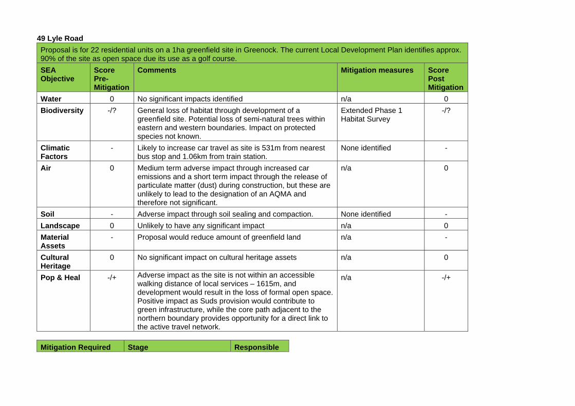
49 Lyle Road
Proposal is for 22 residential units on a 1ha greenfield site in Greenock. The current Local Development Plan identifies approx. 90% of the site as open space due its use as a golf course.
SEA Objective
Score Pre-Mitigation
Comments Mitigation measures Score Post Mitigation
Water 0 No significant impacts identified n/a 0
Biodiversity -/? General loss of habitat through development of a greenfield site. Potential loss of semi-natural trees within eastern and western boundaries. Impact on protected species not known.
Extended Phase 1 Habitat Survey
-/?
Climatic Factors
- Likely to increase car travel as site is 531m from nearest bus stop and 1.06km from train station.
None identified -
Air 0 Medium term adverse impact through increased car emissions and a short term impact through the release of particulate matter (dust) during construction, but these are unlikely to lead to the designation of an AQMA and therefore not significant.
n/a 0
Soil - Adverse impact through soil sealing and compaction. None identified -
Landscape 0 Unlikely to have any significant impact n/a 0
Material Assets
- Proposal would reduce amount of greenfield land n/a -
Cultural Heritage
0 No significant impact on cultural heritage assets n/a 0
Pop & Heal -/+ Adverse impact as the site is not within an accessible walking distance of local services – 1615m, and development would result in the loss of formal open space. Positive impact as Suds provision would contribute to green infrastructure, while the core path adjacent to the northern boundary provides opportunity for a direct link to the active travel network.
n/a -/+
Mitigation Required Stage Responsible
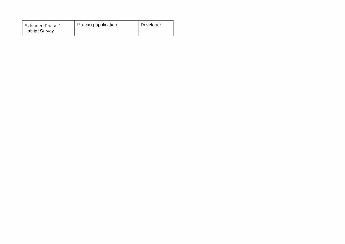
Extended Phase 1 Habitat Survey
Planning application Developer
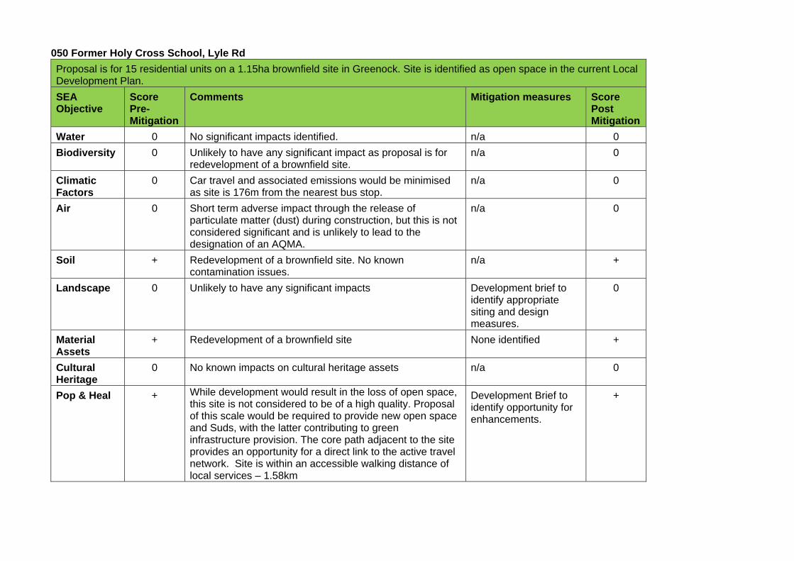
050 Former Holy Cross School, Lyle Rd
Proposal is for 15 residential units on a 1.15ha brownfield site in Greenock. Site is identified as open space in the current Local Development Plan.
SEA Objective
Score Pre-Mitigation
Comments Mitigation measures Score Post Mitigation
Water 0 No significant impacts identified. n/a 0
Biodiversity 0 Unlikely to have any significant impact as proposal is for redevelopment of a brownfield site.
n/a 0
Climatic Factors
0 Car travel and associated emissions would be minimised as site is 176m from the nearest bus stop.
n/a 0
Air 0 Short term adverse impact through the release of particulate matter (dust) during construction, but this is not considered significant and is unlikely to lead to the designation of an AQMA.
n/a 0
Soil + Redevelopment of a brownfield site. No known contamination issues.
n/a +
Landscape 0 Unlikely to have any significant impacts Development brief to identify appropriate siting and design measures.
0
Material Assets
+ Redevelopment of a brownfield site None identified +
Cultural Heritage
0 No known impacts on cultural heritage assets n/a 0
Pop & Heal + While development would result in the loss of open space, this site is not considered to be of a high quality. Proposal of this scale would be required to provide new open space and Suds, with the latter contributing to green infrastructure provision. The core path adjacent to the site provides an opportunity for a direct link to the active travel network. Site is within an accessible walking distance of local services – 1.58km
Development Brief to identify opportunity for enhancements.
+

Mitigation Required Stage Responsible
Development Brief Preparation of the Local Development Plan
Local Authority
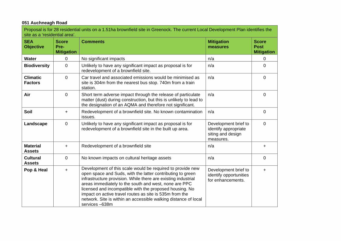
051 Auchneagh Road
Proposal is for 28 residential units on a 1.51ha brownfield site in Greenock. The current Local Development Plan identifies the site as a ‘residential area’.
SEA Objective
Score Pre-Mitigation
Comments Mitigation measures
Score Post Mitigation
Water 0 No significant impacts n/a 0
Biodiversity 0 Unlikely to have any significant impact as proposal is for redevelopment of a brownfield site.
n/a 0
Climatic Factors
0 Car travel and associated emissions would be minimised as site is 304m from the nearest bus stop. 740m from a train station.
n/a 0
Air 0 Short term adverse impact through the release of particulate matter (dust) during construction, but this is unlikely to lead to the designation of an AQMA and therefore not significant.
n/a 0
Soil + Redevelopment of a brownfield site. No known contamination issues.
n/a 0
Landscape 0 Unlikely to have any significant impact as proposal is for redevelopment of a brownfield site in the built up area.
Development brief to identify appropriate siting and design measures.
0
Material Assets
+ Redevelopment of a brownfield site n/a +
Cultural Assets
0 No known impacts on cultural heritage assets n/a 0
Pop & Heal + Development of this scale would be required to provide new open space and Suds, with the latter contributing to green infrastructure provision. While there are existing industrial areas immediately to the south and west, none are PPC licensed and incompatible with the proposed housing. No impact on active travel routes as site is 535m from the network. Site is within an accessible walking distance of local services –638m
Development brief to identify opportunities for enhancements.
+
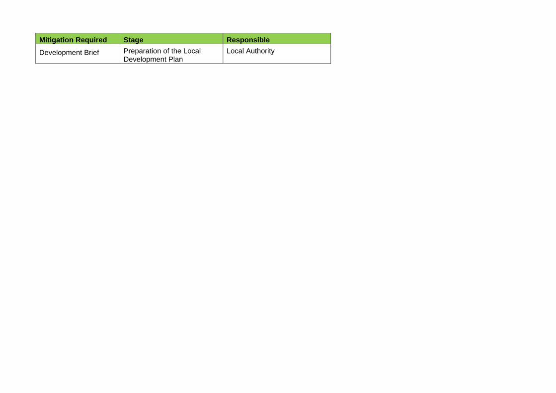
Mitigation Required Stage Responsible
Development Brief Preparation of the Local Development Plan
Local Authority
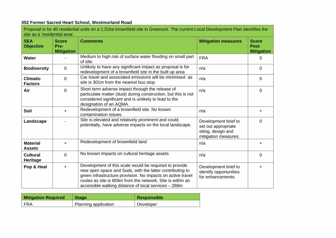
052 Former Sacred Heart School, Westmorland Road
Proposal is for 40 residential units on a 1.31ha brownfield site in Greenock. The current Local Development Plan identifies the site as a ‘residential area’.
SEA Objective
Score Pre-Mitigation
Comments Mitigation measures Score Post Mitigation
Water - Medium to high risk of surface water flooding on small part of site.
FRA 0
Biodiversity 0 Unlikely to have any significant impact as proposal is for redevelopment of a brownfield site in the built up area
n/a 0
Climatic Factors
0 Car travel and associated emissions will be minimised as site is 301m from the nearest bus stop.
n/a 0
Air 0 Short term adverse impact through the release of particulate matter (dust) during construction, but this is not considered significant and is unlikely to lead to the designation of an AQMA.
n/a 0
Soil + Redevelopment of a brownfield site. No known contamination issues.
n/a +
Landscape - Site is elevated and relatively prominent and could, potentially, have adverse impacts on the local landscape.
Development brief to set out appropriate siting, design and mitigation measures.
0
Material Assets
+ Redevelopment of brownfield land n/a +
Cultural Heritage
0 No known impacts on cultural heritage assets n/a 0
Pop & Heal + Development of this scale would be required to provide new open space and Suds, with the latter contributing to green infrastructure provision. No impacts on active travel routes as site is 859m from the network. Site is within an accessible walking distance of local services – 268m
Development brief to identify opportunities for enhancements.
+
Mitigation Required Stage Responsible
FRA Planning application Developer
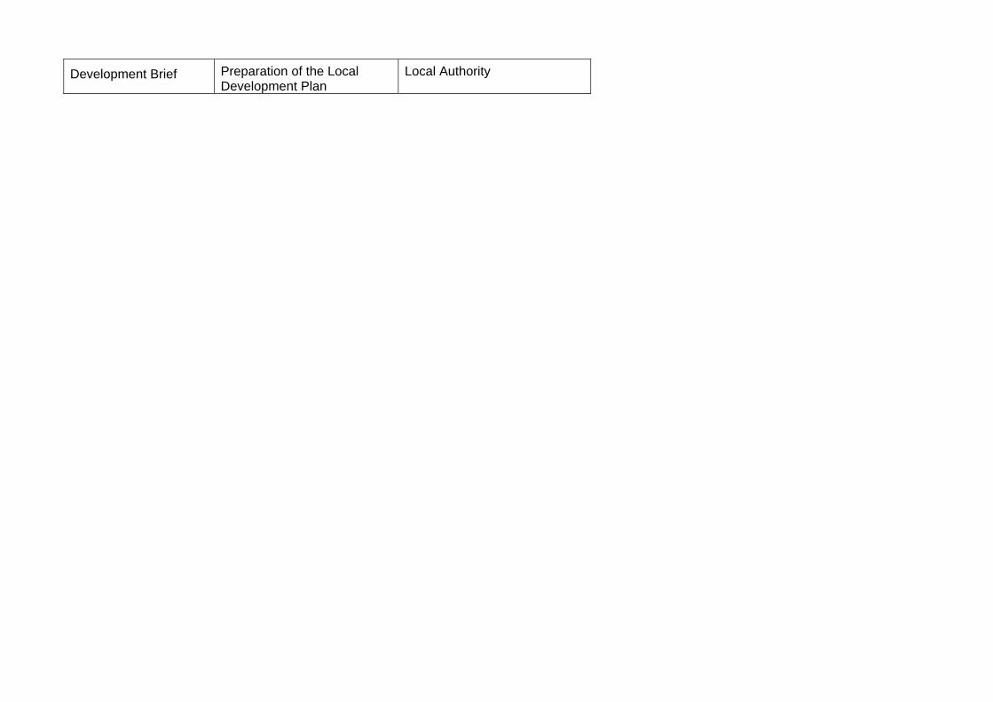
Development Brief Preparation of the Local Development Plan
Local Authority
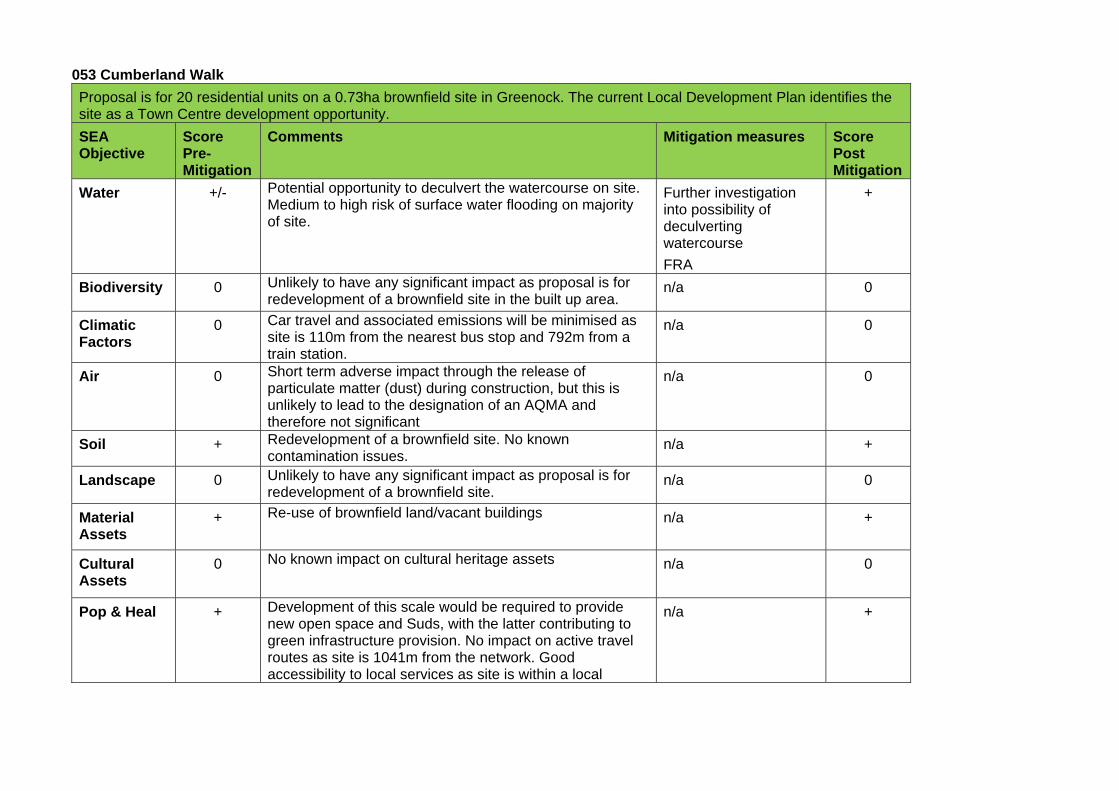
053 Cumberland Walk
Proposal is for 20 residential units on a 0.73ha brownfield site in Greenock. The current Local Development Plan identifies the site as a Town Centre development opportunity.
SEA Objective
Score Pre-Mitigation
Comments Mitigation measures Score Post Mitigation
Water +/- Potential opportunity to deculvert the watercourse on site. Medium to high risk of surface water flooding on majority of site.
Further investigation into possibility of deculverting watercourse
FRA
+
Biodiversity 0 Unlikely to have any significant impact as proposal is for redevelopment of a brownfield site in the built up area.
n/a 0
Climatic Factors
0 Car travel and associated emissions will be minimised as site is 110m from the nearest bus stop and 792m from a train station.
n/a 0
Air 0 Short term adverse impact through the release of particulate matter (dust) during construction, but this is unlikely to lead to the designation of an AQMA and therefore not significant
n/a 0
Soil + Redevelopment of a brownfield site. No known contamination issues.
n/a +
Landscape 0 Unlikely to have any significant impact as proposal is for redevelopment of a brownfield site.
n/a 0
Material Assets
+ Re-use of brownfield land/vacant buildings n/a +
Cultural Assets
0 No known impact on cultural heritage assets n/a 0
Pop & Heal + Development of this scale would be required to provide new open space and Suds, with the latter contributing to green infrastructure provision. No impact on active travel routes as site is 1041m from the network. Good accessibility to local services as site is within a local
n/a +
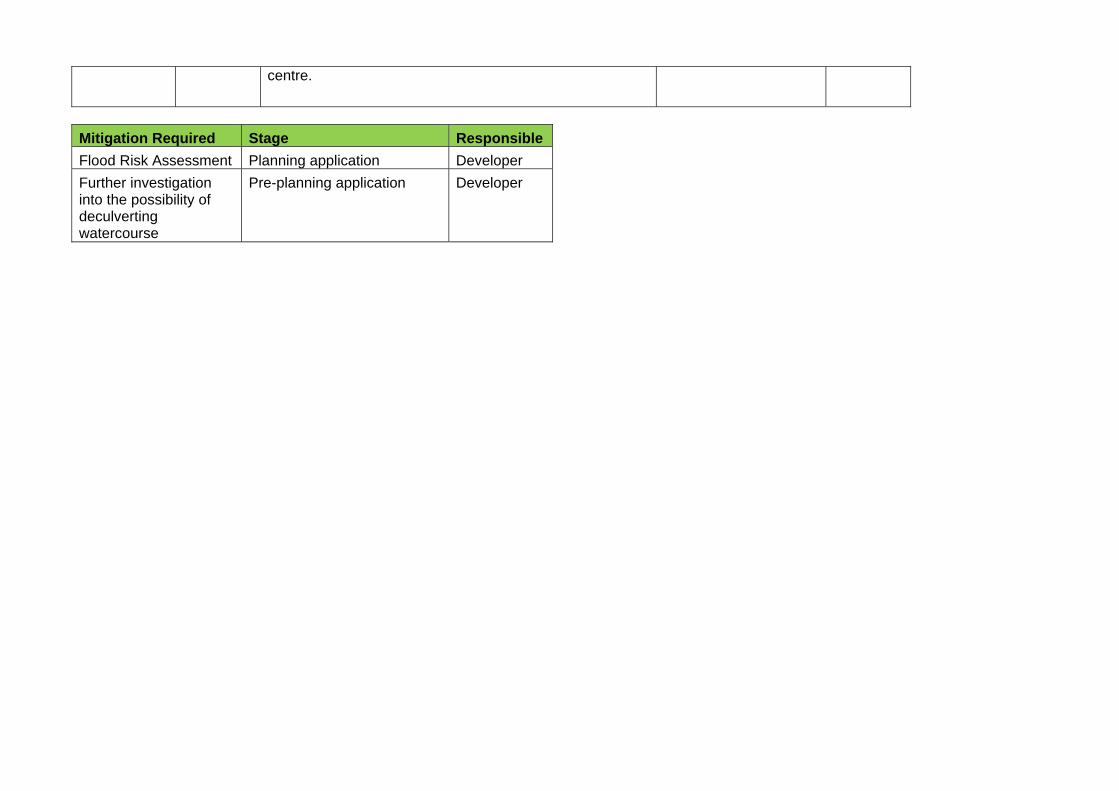
centre.
Mitigation Required Stage Responsible
Flood Risk Assessment Planning application Developer
Further investigation into the possibility of deculverting watercourse
Pre-planning application Developer
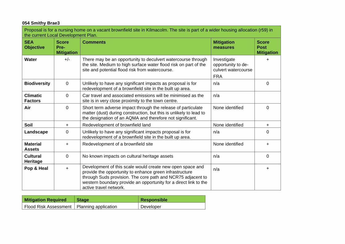
054 Smithy Brae3
Proposal is for a nursing home on a vacant brownfield site in Kilmacolm. The site is part of a wider housing allocation (r59) in the current Local Development Plan.
SEA Objective
Score Pre-Mitigation
Comments Mitigation measures
Score Post Mitigation
Water +/- There may be an opportunity to deculvert watercourse through the site. Medium to high surface water flood risk on part of the site and potential flood risk from watercourse.
Investigate opportunity to de-culvert watercourse
FRA
+
Biodiversity 0 Unlikely to have any significant impacts as proposal is for redevelopment of a brownfield site in the built up area.
n/a 0
Climatic Factors
0 Car travel and associated emissions will be minimised as the site is in very close proximity to the town centre.
n/a
Air 0 Short term adverse impact through the release of particulate matter (dust) during construction, but this is unlikely to lead to the designation of an AQMA and therefore not significant.
None identified 0
Soil + Redevelopment of brownfield land None identified +
Landscape 0 Unlikely to have any significant impacts proposal is for redevelopment of a brownfield site in the built up area.
n/a 0
Material Assets
+ Redevelopment of a brownfield site None identified +
Cultural Heritage
0 No known impacts on cultural heritage assets n/a 0
Pop & Heal + Development of this scale would create new open space and provide the opportunity to enhance green infrastructure through Suds provision. The core path and NCR75 adjacent to western boundary provide an opportunity for a direct link to the active travel network.
n/a +
Mitigation Required Stage Responsible
Flood Risk Assessment Planning application Developer
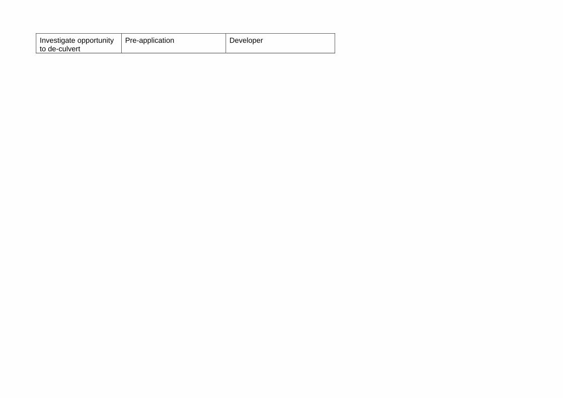
Investigate opportunity to de-culvert
Pre-application Developer
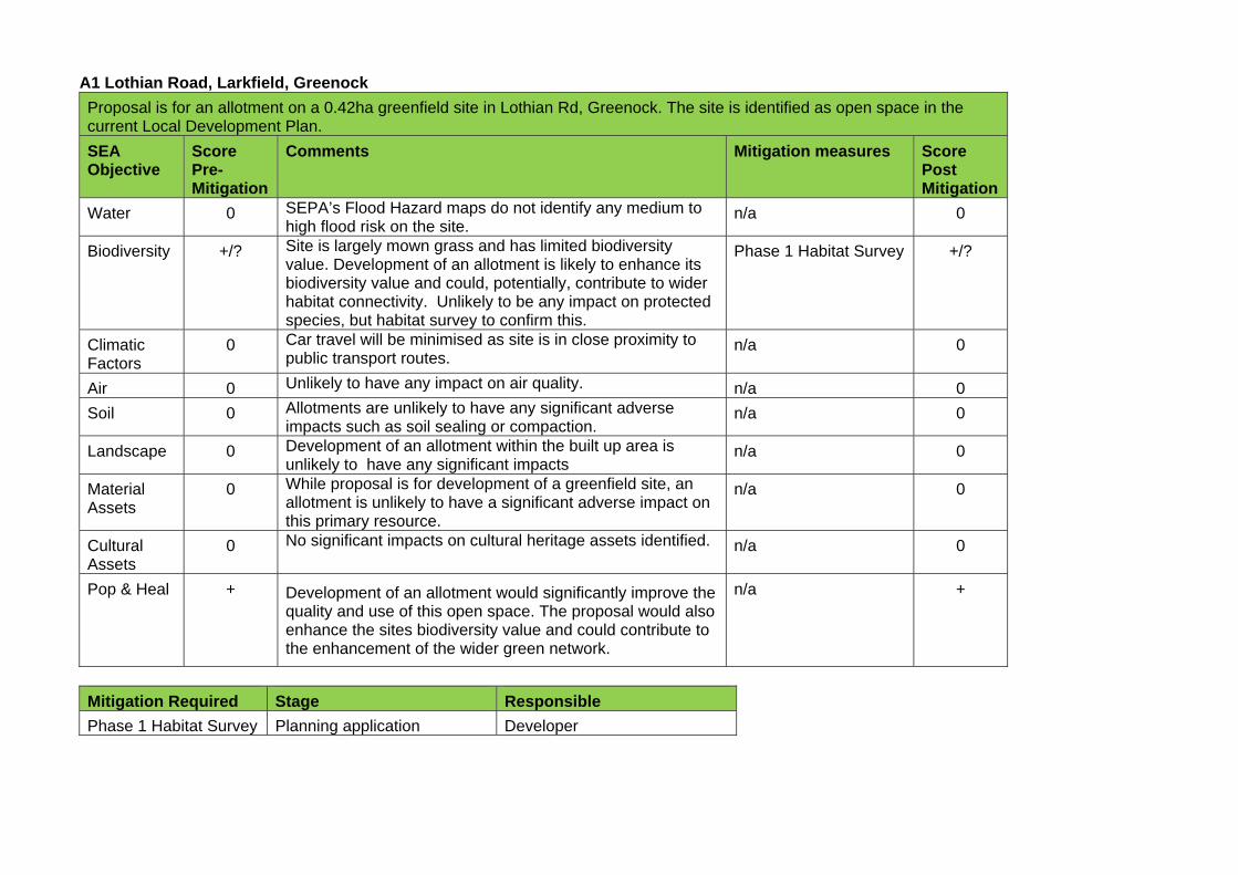
A1 Lothian Road, Larkfield, Greenock
Proposal is for an allotment on a 0.42ha greenfield site in Lothian Rd, Greenock. The site is identified as open space in the current Local Development Plan.
SEA Objective
Score Pre-Mitigation
Comments Mitigation measures Score Post Mitigation
Water 0 SEPA’s Flood Hazard maps do not identify any medium to high flood risk on the site.
n/a 0
Biodiversity +/? Site is largely mown grass and has limited biodiversity value. Development of an allotment is likely to enhance its biodiversity value and could, potentially, contribute to wider habitat connectivity. Unlikely to be any impact on protected species, but habitat survey to confirm this.
Phase 1 Habitat Survey +/?
Climatic Factors
0 Car travel will be minimised as site is in close proximity to public transport routes.
n/a 0
Air 0 Unlikely to have any impact on air quality. n/a 0
Soil 0 Allotments are unlikely to have any significant adverse impacts such as soil sealing or compaction.
n/a 0
Landscape 0 Development of an allotment within the built up area is unlikely to have any significant impacts
n/a 0
Material Assets
0 While proposal is for development of a greenfield site, an allotment is unlikely to have a significant adverse impact on this primary resource.
n/a 0
Cultural Assets
0 No significant impacts on cultural heritage assets identified. n/a 0
Pop & Heal + Development of an allotment would significantly improve the quality and use of this open space. The proposal would also enhance the sites biodiversity value and could contribute to the enhancement of the wider green network.
n/a +
Mitigation Required Stage Responsible
Phase 1 Habitat Survey Planning application Developer
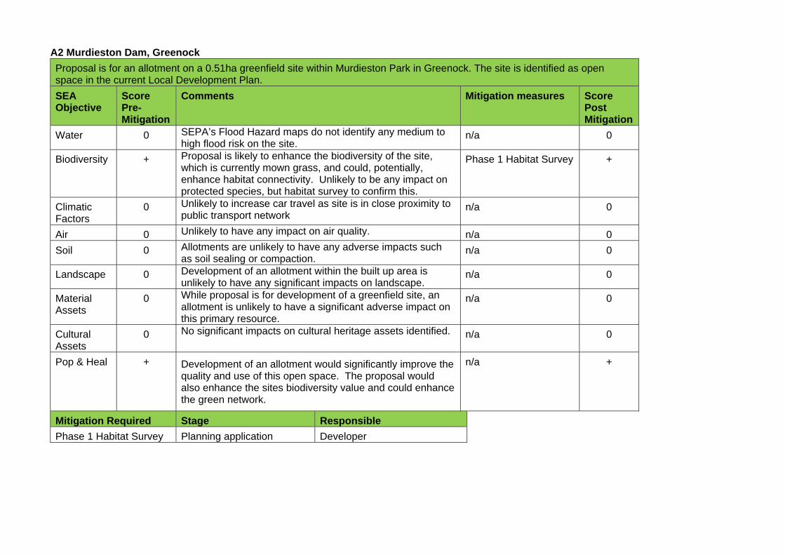
A2 Murdieston Dam, Greenock
Proposal is for an allotment on a 0.51ha greenfield site within Murdieston Park in Greenock. The site is identified as open space in the current Local Development Plan.
SEA Objective
Score Pre-Mitigation
Comments Mitigation measures Score Post Mitigation
Water 0 SEPA’s Flood Hazard maps do not identify any medium to high flood risk on the site.
n/a 0
Biodiversity + Proposal is likely to enhance the biodiversity of the site, which is currently mown grass, and could, potentially, enhance habitat connectivity. Unlikely to be any impact on protected species, but habitat survey to confirm this.
Phase 1 Habitat Survey +
Climatic Factors
0 Unlikely to increase car travel as site is in close proximity to public transport network
n/a 0
Air 0 Unlikely to have any impact on air quality. n/a 0
Soil 0 Allotments are unlikely to have any adverse impacts such as soil sealing or compaction.
n/a 0
Landscape 0 Development of an allotment within the built up area is unlikely to have any significant impacts on landscape.
n/a 0
Material Assets
0 While proposal is for development of a greenfield site, an allotment is unlikely to have a significant adverse impact on this primary resource.
n/a 0
Cultural Assets
0 No significant impacts on cultural heritage assets identified. n/a 0
Pop & Heal + Development of an allotment would significantly improve the quality and use of this open space. The proposal would also enhance the sites biodiversity value and could enhance the green network.
n/a +
Mitigation Required Stage Responsible
Phase 1 Habitat Survey Planning application Developer
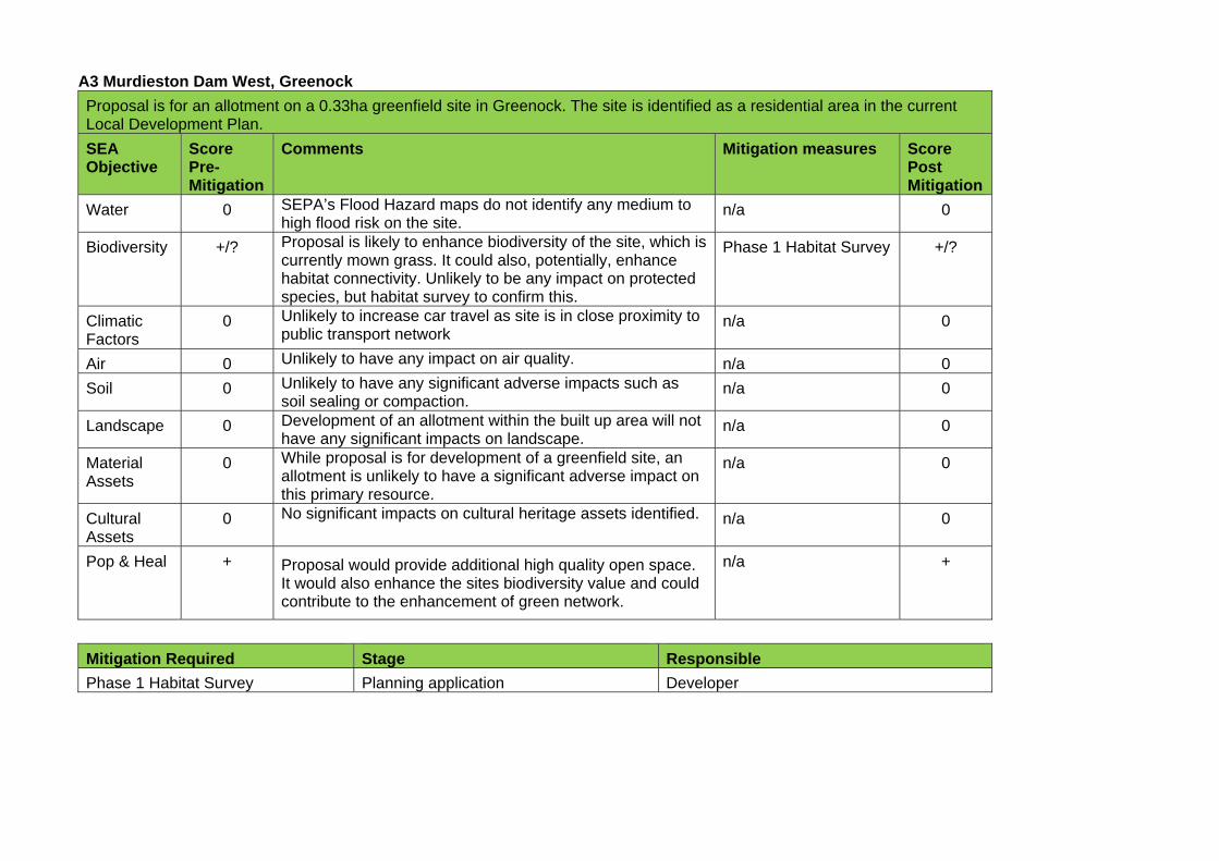
A3 Murdieston Dam West, Greenock
Proposal is for an allotment on a 0.33ha greenfield site in Greenock. The site is identified as a residential area in the current Local Development Plan.
SEA Objective
Score Pre-Mitigation
Comments Mitigation measures Score Post Mitigation
Water 0 SEPA’s Flood Hazard maps do not identify any medium to high flood risk on the site.
n/a 0
Biodiversity +/? Proposal is likely to enhance biodiversity of the site, which is currently mown grass. It could also, potentially, enhance habitat connectivity. Unlikely to be any impact on protected species, but habitat survey to confirm this.
Phase 1 Habitat Survey +/?
Climatic Factors
0 Unlikely to increase car travel as site is in close proximity to public transport network
n/a 0
Air 0 Unlikely to have any impact on air quality. n/a 0
Soil 0 Unlikely to have any significant adverse impacts such as soil sealing or compaction.
n/a 0
Landscape 0 Development of an allotment within the built up area will not have any significant impacts on landscape.
n/a 0
Material Assets
0 While proposal is for development of a greenfield site, an allotment is unlikely to have a significant adverse impact on this primary resource.
n/a 0
Cultural Assets
0 No significant impacts on cultural heritage assets identified. n/a 0
Pop & Heal + Proposal would provide additional high quality open space. It would also enhance the sites biodiversity value and could contribute to the enhancement of green network.
n/a +
Mitigation Required Stage Responsible
Phase 1 Habitat Survey Planning application Developer
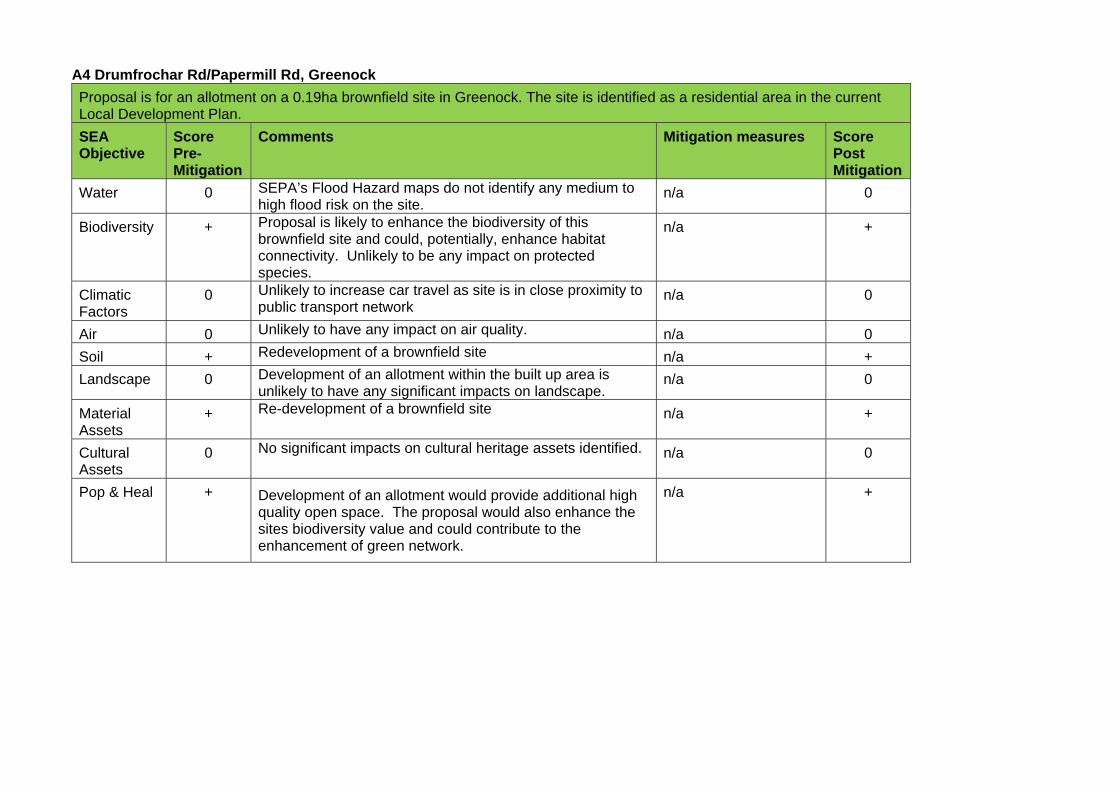
A4 Drumfrochar Rd/Papermill Rd, Greenock
Proposal is for an allotment on a 0.19ha brownfield site in Greenock. The site is identified as a residential area in the current Local Development Plan.
SEA Objective
Score Pre-Mitigation
Comments Mitigation measures Score Post Mitigation
Water 0 SEPA’s Flood Hazard maps do not identify any medium to high flood risk on the site.
n/a 0
Biodiversity + Proposal is likely to enhance the biodiversity of this brownfield site and could, potentially, enhance habitat connectivity. Unlikely to be any impact on protected species.
n/a +
Climatic Factors
0 Unlikely to increase car travel as site is in close proximity to public transport network
n/a 0
Air 0 Unlikely to have any impact on air quality. n/a 0
Soil + Redevelopment of a brownfield site n/a +
Landscape 0 Development of an allotment within the built up area is unlikely to have any significant impacts on landscape.
n/a 0
Material Assets
+ Re-development of a brownfield site n/a +
Cultural Assets
0 No significant impacts on cultural heritage assets identified. n/a 0
Pop & Heal + Development of an allotment would provide additional high quality open space. The proposal would also enhance the sites biodiversity value and could contribute to the enhancement of green network.
n/a +
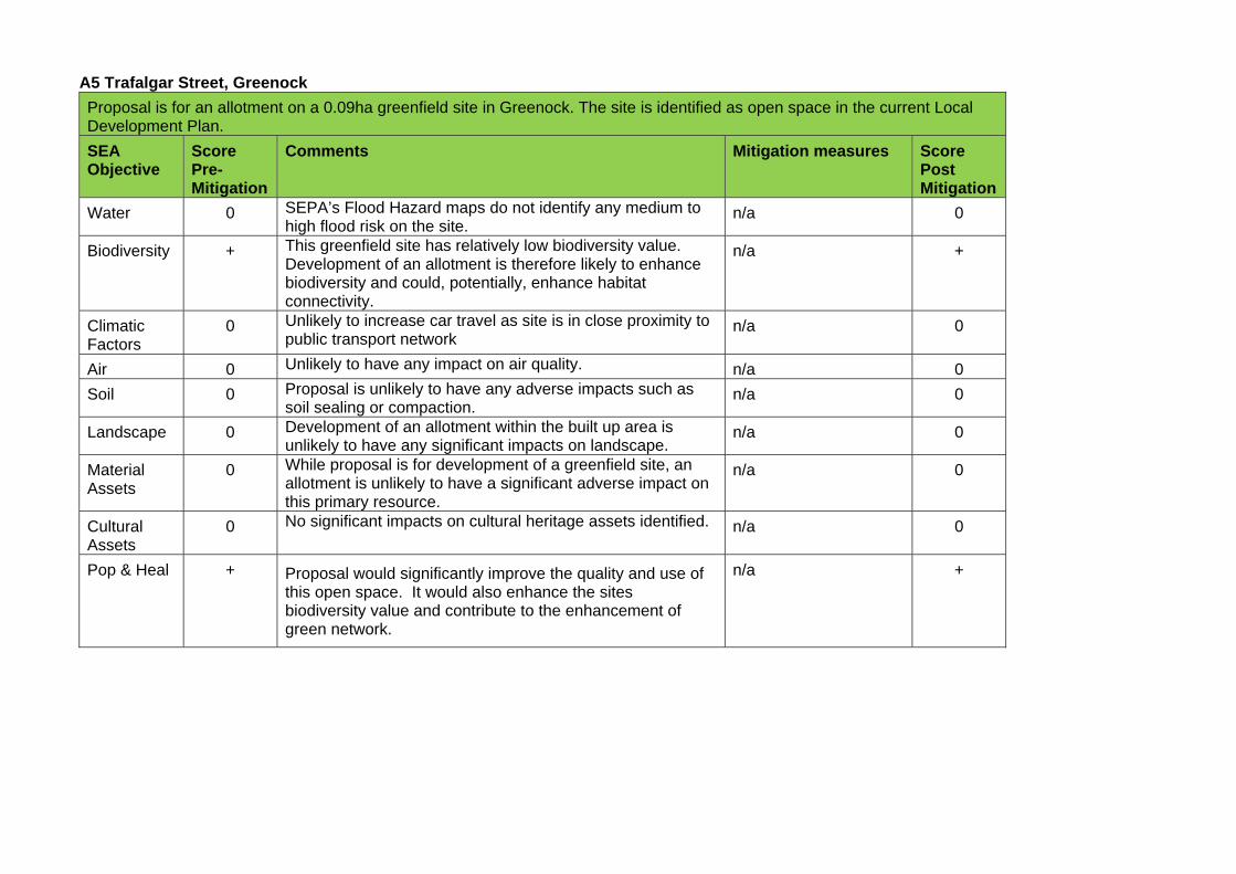
A5 Trafalgar Street, Greenock
Proposal is for an allotment on a 0.09ha greenfield site in Greenock. The site is identified as open space in the current Local Development Plan.
SEA Objective
Score Pre-Mitigation
Comments Mitigation measures Score Post Mitigation
Water 0 SEPA’s Flood Hazard maps do not identify any medium to high flood risk on the site.
n/a 0
Biodiversity + This greenfield site has relatively low biodiversity value. Development of an allotment is therefore likely to enhance biodiversity and could, potentially, enhance habitat connectivity.
n/a +
Climatic Factors
0 Unlikely to increase car travel as site is in close proximity to public transport network
n/a 0
Air 0 Unlikely to have any impact on air quality. n/a 0
Soil 0 Proposal is unlikely to have any adverse impacts such as soil sealing or compaction.
n/a 0
Landscape 0 Development of an allotment within the built up area is unlikely to have any significant impacts on landscape.
n/a 0
Material Assets
0 While proposal is for development of a greenfield site, an allotment is unlikely to have a significant adverse impact on this primary resource.
n/a 0
Cultural Assets
0 No significant impacts on cultural heritage assets identified. n/a 0
Pop & Heal + Proposal would significantly improve the quality and use of this open space. It would also enhance the sites biodiversity value and contribute to the enhancement of green network.
n/a +
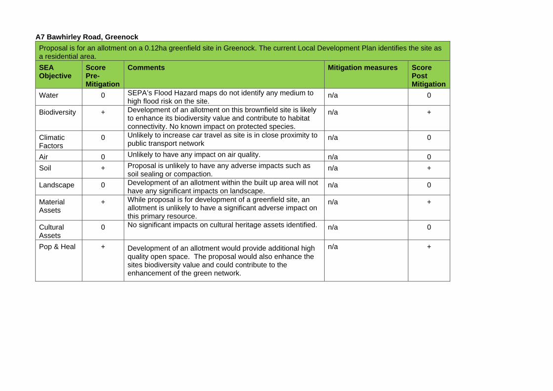
A7 Bawhirley Road, Greenock
Proposal is for an allotment on a 0.12ha greenfield site in Greenock. The current Local Development Plan identifies the site as a residential area.
SEA Objective
Score Pre-Mitigation
Comments Mitigation measures Score Post Mitigation
Water 0 SEPA’s Flood Hazard maps do not identify any medium to high flood risk on the site.
n/a 0
Biodiversity + Development of an allotment on this brownfield site is likely to enhance its biodiversity value and contribute to habitat connectivity. No known impact on protected species.
n/a +
Climatic Factors
0 Unlikely to increase car travel as site is in close proximity to public transport network
n/a 0
Air 0 Unlikely to have any impact on air quality. n/a 0
Soil + Proposal is unlikely to have any adverse impacts such as soil sealing or compaction.
n/a +
Landscape 0 Development of an allotment within the built up area will not have any significant impacts on landscape.
n/a 0
Material Assets
+ While proposal is for development of a greenfield site, an allotment is unlikely to have a significant adverse impact on this primary resource.
n/a +
Cultural Assets
0 No significant impacts on cultural heritage assets identified. n/a 0
Pop & Heal + Development of an allotment would provide additional high quality open space. The proposal would also enhance the sites biodiversity value and could contribute to the enhancement of the green network.
n/a +
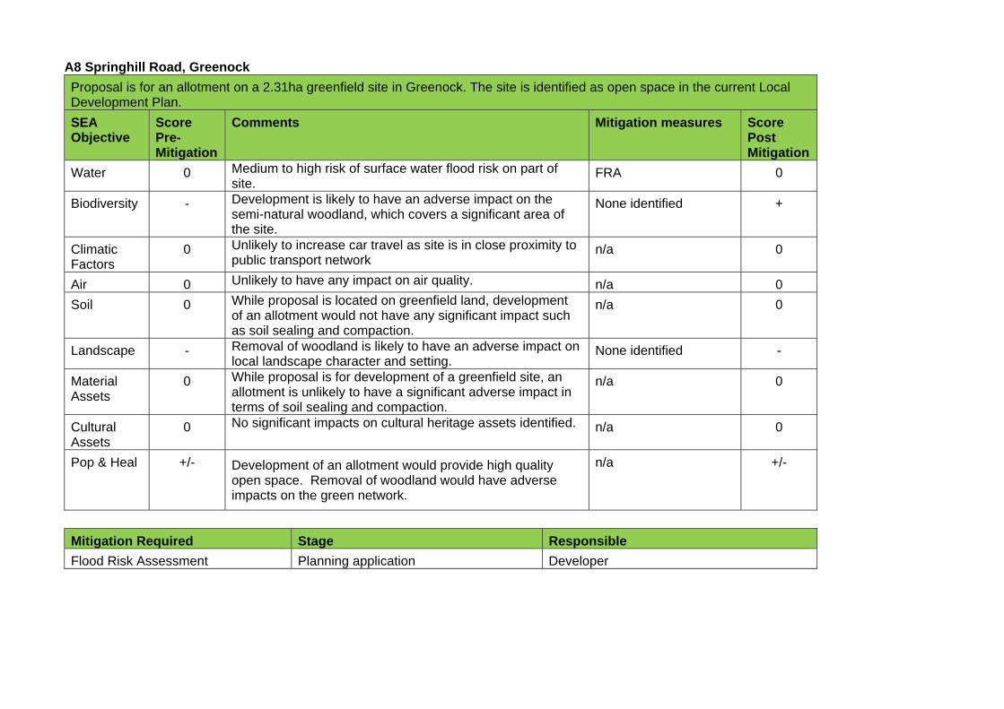
A8 Springhill Road, Greenock
Proposal is for an allotment on a 2.31ha greenfield site in Greenock. The site is identified as open space in the current Local Development Plan.
SEA Objective
Score Pre-Mitigation
Comments Mitigation measures Score Post Mitigation
Water 0 Medium to high risk of surface water flood risk on part of site.
FRA 0
Biodiversity - Development is likely to have an adverse impact on the semi-natural woodland, which covers a significant area of the site.
None identified +
Climatic Factors
0 Unlikely to increase car travel as site is in close proximity to public transport network
n/a 0
Air 0 Unlikely to have any impact on air quality. n/a 0
Soil 0 While proposal is located on greenfield land, development of an allotment would not have any significant impact such as soil sealing and compaction.
n/a 0
Landscape - Removal of woodland is likely to have an adverse impact on local landscape character and setting.
None identified -
Material Assets
0 While proposal is for development of a greenfield site, an allotment is unlikely to have a significant adverse impact in terms of soil sealing and compaction.
n/a 0
Cultural Assets
0 No significant impacts on cultural heritage assets identified. n/a 0
Pop & Heal +/- Development of an allotment would provide high quality open space. Removal of woodland would have adverse impacts on the green network.
n/a +/-
Mitigation Required Stage Responsible
Flood Risk Assessment Planning application Developer
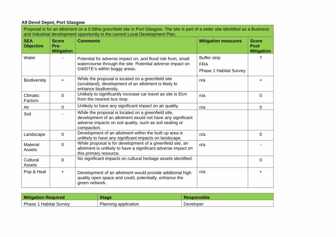
A9 Devol Depot, Port Glasgow
Proposal is for an allotment on a 0.58ha greenfield site in Port Glasgow. The site is part of a wider site identified as a Business and Industrial development opportunity in the current Local Development Plan.
SEA Objective
Score Pre-Mitigation
Comments Mitigation measures Score Post Mitigation
Water - Potential for adverse impact on, and flood risk from, small watercourse through the site. Potential adverse impact on GWDTE’s within boggy areas.
Buffer strip
FRA
Phase 1 Habitat Survey
?
Biodiversity + While the proposal is located on a greenfield site (scrubland), development of an allotment is likely to enhance biodiversity.
n/a +
Climatic Factors
0 Unlikely to significantly increase car travel as site is 81m from the nearest bus stop.
n/a 0
Air 0 Unlikely to have any significant impact on air quality. n/a 0
Soil - While the proposal is located on a greenfield site, development of an allotment would not have any significant adverse impacts on soil quality, such as soil sealing or compaction.
Landscape 0 Development of an allotment within the built up area is unlikely to have any significant impacts on landscape.
n/a 0
Material Assets
0 While proposal is for development of a greenfield site, an allotment is unlikely to have a significant adverse impact on this primary resource.
n/a -
Cultural Assets
0 No significant impacts on cultural heritage assets identified. 0
Pop & Heal + Development of an allotment would provide additional high quality open space and could, potentially, enhance the green network.
n/a +
Mitigation Required Stage Responsible
Phase 1 Habitat Survey Planning application Developer
Buffer strip Planning application Developer
Flood Risk Assessment Planning application Developer

APPENDIX F: ENVIRONMENTAL CONSTRAINTS MAP
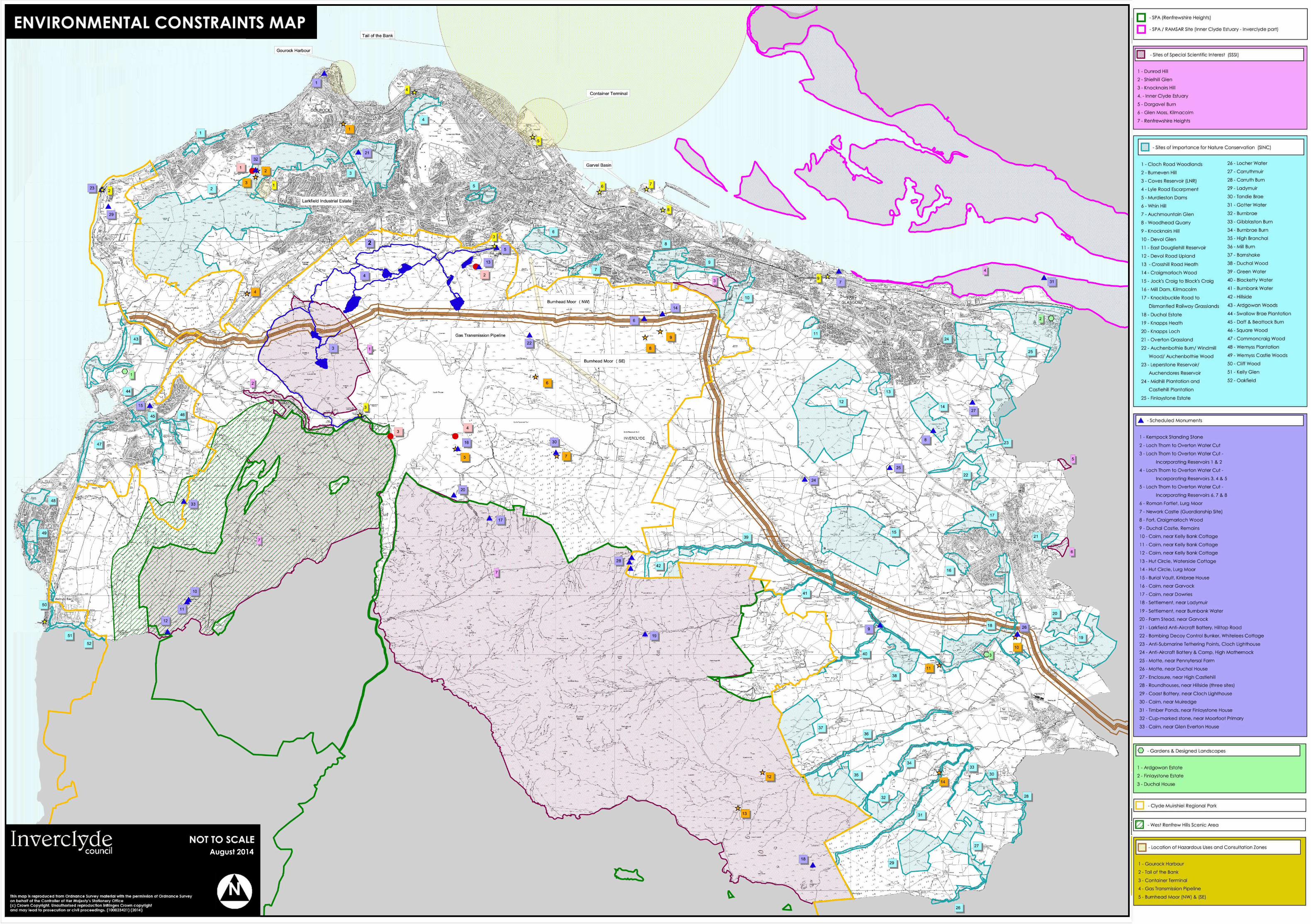

Regeneration and PlanningInverclyde CouncilMunicipal BuildingsClyde SquareGreenockPA15 1LY
Telephone:Telephone: 01475 712491
E-mail: [email protected]
Web: www.inverclyde.gov.uk/newldp