Embed Size (px)
Citation preview
Louisville District
Shoreline Management Plan Barren River Lake Nolin River Lake Rough River Lake 2011

- i -
Shoreline Management Plan
Table of Contents
Section Title Page
1. Purpose and Scope…………………………………………… 1 1.1. Purpose ………….………………………………. 1
1.2. Scope…………………………………………….. 1 2. Policy………………………………………………………….. 1 3. References……………………………………………………. 1 4. Objectives…………………………………………………….. 2 5. Development of Shoreline Management Plan……………… 2 5.1. Background………………………………………. 2 5.2. Revisions and Updates…………………………... 3 6. Shoreline Allocation…………………………………………. 3
6.1. General…………………………………………... 3 6.2. Types of Zoning…………………………………... 3 7. Zoning Changes……………………………………………… 4 7.1. Approved Zoning………………………………… 4 7.2. Re-evaluation of Limited Development Areas….. 4 8. Encroachments and Trespasses…………………………….. 5 8.1. Consequences……………………………………. 5 8.2. Private Survey…………………………………… 6 8.3. Removal of Unauthorized Structures…………… 6 9. Boundary Identification…………………………………….. 6 9.1. Corps of Engineers Actions……………………… 6 9.2. Landowners Actions……………………………… 7 10. Flowage Easements…………………………………………… 7 11. Shoreline Use in Limited Development Areas………………. 7 11.1. General…………………………………………... 7 11.2. Compliance with Approved Plans……………….. 8 11.3. Compliance Inspections…………………………. 8 11.4. Renewals………………………………………… 8 11.5. Transfer of Licenses/Permits……………………. 8 11.6. Grandfathered Facilities…………………………. 9

- ii -
Section Title Page
11.7. Appeal Rights……………………………………... 9
11.8. Prohibited Items or Activities…………………….. 9 12. Licenses…………………………………………………………. 11 12.1. Encroachment or Trespass………………………... 11 12.2. Fees……………………………………………….. 12 12.3. Conditions………………………………………… 12 13. Water Lines and Water Withdrawal (license)……………….. 12 14 Improved Pedestrian Access (license)………………………… 12 14.1. Purpose and Scope………………………………… 13 14.2 Grandfathered Facilities…………………………… 13 14.3. Limits and Shared Access Requirements…………. 13 14.4. Eligibility…………………………………………. 13 14.5. Improved Footpaths………………………………. 14 14.6. Cart Paths…………………………………………. 14 Drawing No. 1 (Cart Path)………………………. 16 14.7 Incline Elevators and Similar Devices 17 14.8. Footbridges………………………………………... 17 14.9. Stairways and Steps……………………………….. 18 Drawing No. 2 (Step Plan)………………………. 20 Drawing No. 3 (Anchoring)…………………….. 21 Drawing No. 4 (Foot Path)……………………… 22 15. Roadways, Turnarounds, Parking
Areas and Ramps (license)……………………………. 23 15.1. Ramps……………………………………………. 23 Drawing No. 5 (Ramp Specifications)……….... 24 15.2. Roads…………………………………………….. 25 15.3. Parking Areas and Turnarounds…………………. 25 15.4. Special Considerations…………………………… 25 16. Grandfathered Electrical Use (license)………………………. 26 16.1. Safety and Interference…………………………… 26 16.2. Electric Codes……………………………………. 26 16.3. Inspections……………………………………….. 26 16.4. Ground Fault Interrupters………………………… 26 16.5. Wire……………………………………………… 27 16.6. Conduit Boxes…………………………………… 27 16.7. Security Lights…………………………………… 27 16.8. Convenience Outlets……………………………… 27
- iii -
Section Title Page
17. Permits………………………………………………………. 27 17.1. Encroachment or Trespass…………………….. 27 17.2. Fees……………………………………………. 27
17.3. Conditions……………………………………... 28 17.4. Permit Revocation……………………………... 32 18. Use of Electricity (Permit).................................................... 32 18.1. Electrical Generating Equipment……………… 32 18.2. Solar Power……………………………………. 32 18.3. Storage of Electrical Generating Equipment….. 32 18.4. Conditions……………………………………… 32 19. Erosion Control Devices (Permit)………………………….. 33 19.1. Purpose………………………………………… 33 19.2. Fee……………………………………………... 33 19.3. Erosion at Permitted Structures……………….. 33 19.4. Materials and Limits…………………………... 34 20. Groups Boat Docks (Permit)……………………………….. 34 20.1. Individual Slips………………………………... 34 20.2. Point of Contact……………………………….. 34 20.3. Privacy Act……………………………………. 34 20.4. Eligibility……………………………………… 35 20.5. Purchase of Existing Slips…………………….. 36 20.6. Grandfathered Facilities………………………. 36 20.7. Location of Group Docks…….……………….. 37 20.8. Size and Configuration……….……………….. 38 20.9. Slip Design…………………….……………… 39 20.10. Anchoring……………………………………. 40 20.11. Appurtenant Structures………………………. 41 20.12. Special Considerations………………………. 42 Group Floating Dock Specifications Drawings Nos. 6 thru 12…………..... 44 - 50 21. Vegetation Alteration and
Unimproved Paths (Permit)……………………….. 51 21.1. Purpose………………………………………… 51 21.2. Permit Terms………………………………….. 51 21.3. Eligibility……………………………………… 51 21.4. Size and Configuration……………………….. 51 21.5. Grandfathered Permits for VA and Unimproved Paths………………………….. 52
- iv -
Section Title Page
21.6. Scope………………………………………….. 52
21.7. Marking Boundary Line………………………. 53 Typical Vegetation Alteration Drawings Nos. 13 and 14…………… 54 - 55 22. Specified Act Permits………………………………………. 56 22.1. Purpose……………………………….……….. 56 22.2. Habitat Mitigation…………………….………. 56 22.3. Habitat Enhancement and Restoration..………. 56
22.4. Application……………………………………. 56 22.5. Term…………………………………………… 56 22.6. Fee……………………………………………... 56 23. Section 404 and Section 10 Permits………………………… 56 24. Duck Blinds………………………………………………….. 57 25. Fish and Wildlife…………………………………………….. 57 26. Grandfathered Facilities Unique to
Rough River Lake…………………………………… 57 26.1. General…………………………………………. 57 26.2. Vegetation Alteration………………………….. 57 26.3. Group Boat Docks……………………………... 57 26.4. Access Improvements…………………………. 58 26.5. Grandfathered Permits and Licenses………….. 58
- 1 -
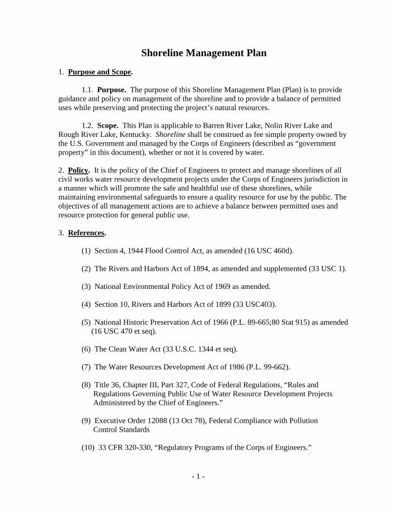
Shoreline Management Plan 1. Purpose and Scope
.
1.1. Purpose. The purpose of this Shoreline Management Plan (Plan) is to provide guidance and policy on management of the shoreline and to provide a balance of permitted uses while preserving and protecting the project’s natural resources.
1.2. Scope. This Plan is applicable to Barren River Lake, Nolin River Lake and Rough River Lake, Kentucky. Shoreline shall be construed as fee simple property owned by the U.S. Government and managed by the Corps of Engineers (described as “government property” in this document), whether or not it is covered by water. 2. Policy
. It is the policy of the Chief of Engineers to protect and manage shorelines of all civil works water resource development projects under the Corps of Engineers jurisdiction in a manner which will promote the safe and healthful use of these shorelines, while maintaining environmental safeguards to ensure a quality resource for use by the public. The objectives of all management actions are to achieve a balance between permitted uses and resource protection for general public use.
3. References
.
(1) Section 4, 1944 Flood Control Act, as amended (16 USC 460d). (2) The Rivers and Harbors Act of 1894, as amended and supplemented (33 USC 1). (3) National Environmental Policy Act of 1969 as amended. (4) Section 10, Rivers and Harbors Act of 1899 (33 USC403). (5) National Historic Preservation Act of 1966 (P.L. 89-665;80 Stat 915) as amended (16 USC 470 et seq). (6) The Clean Water Act (33 U.S.C. 1344 et seq). (7) The Water Resources Development Act of 1986 (P.L. 99-662). (8) Title 36, Chapter III, Part 327, Code of Federal Regulations, “Rules and Regulations Governing Public Use of Water Resource Development Projects Administered by the Chief of Engineers.”
(9) Executive Order 12088 (13 Oct 78), Federal Compliance with Pollution Control Standards
(10) 33 CFR 320-330, “Regulatory Programs of the Corps of Engineers.”

- 2 -
(11) ER 1130-2-540, “Environmental Stewardship Operations and Maintenance Policies” (including EP 1130-2-540 Guidance) (12) ER 1130-2-550, “Recreation Operations and Maintenance Policies” (including EP 1130-2-550 Guidance) (13) ER 1130-2-406, “Shoreline Management at Civil Works Projects.” (14) EM 385-1-1, “Safety and Health Requirements Manual.”
(15) CEORDR 405-2-13, “Issuance of Minor Licenses and Permits at Water Resource Projects.” (16) LEDR 1130-1-14, “Impoundment and Disposal of Abandoned Private Personal Property.”
(17) ER 1110-2-4401, “Clearances for Power and Communication Lines Over Reservoirs.”
4. Objectives
. The objectives of this Plan are:
(1) To promote the safe and healthful use of the shoreline for recreational purposes for the general public. (2) To preserve and protect the lake’s natural resources and environmental quality.
(3) To manage use of public property in a manner that maintains a balance between development and the protection of the resource for general public use. (4) To minimize the impact of authorized uses upon resources.
(5) To promote restoration of the shoreline where degradation has occurred. (6) To manage the project shoreline to establish, enhance and maintain fish and wildlife habitat. (7) To protect aesthetic quality and sustain natural conditions. 5. Development of Shoreline Management Plan
.
5.1. Background. A Shoreline Management Plan is required for each Corps of Engineers’ project where shoreline use is allowed (paragraph 4.c of reference 3 (13)). The original Shoreline (Lakeshore) Management Plan was developed through a public participation process and put into effect in 1976. This plan allocated the lakeshore for the entire lake into the various classifications or zones and outlined the authorized activities for each zone. The last update was in August 2005, and was approved after completing the

- 3 -
public review process and incorporating valid public concerns. Current guidance requires that Shoreline Management Plans be reviewed periodically by the District Commander, but no less often than every five years, to determine the need for an update.
5.2. Revisions and Updates. Zoning changes are considered a major change to the Plan requiring a formal revision or update, including public involvement. The Plan must also be formally updated when it is determined that other substantial changes are needed. A moratorium may be placed on issuing new permits and licenses in areas considered for a zoning (or other) change, until the formal update can be completed. District Commanders may make minor revisions to the Plan when the revisions are consistent with policy, and funds for a complete Plan update are not available. A change in the fee schedules for permits and/or licenses does not constitute a major revision of the Plan and will not require an update of the Plan. 6. Shoreline Allocation
.
6.1. General. Shoreline allocation (zoning) is the designation of government property into various classifications under which specific activities or uses are permitted for each classification. The allocations have been made to provide for management and protection of project resources for the benefit of the general public, while allowing a level of development to adjacent property owners. The entire shoreline has been allocated into the classifications outlined in Section 6.2. below. A large map identifying the shoreline zoning is available for viewing at the applicable project offices. The classification assigned to the shoreline applies to the land and water. When different classifications exist on opposite sides of the lake or a cove, the respective zonings apply to the mid-point between the shorelines. 6.2. Types of Zoning. 6.2.1. Prohibited Access. Public access is not allowed in Prohibited Access Areas for health, safety or security reasons. These areas generally include the dams, outlet structures, spillways, and adjacent areas that are set aside for project operations. No other shoreline development is permitted in or near these areas. 6.2.2. Public Recreation Areas. These are areas designated for concentrated use by the general public and include Corps of Engineers operated campgrounds, day use areas and launching ramps, commercial concessionaire facilities, and recreation areas operated by other Federal, state or local agencies. No other shoreline development is permitted in or near these areas. 6.2.3 Protected Shoreline Areas. These are areas where no new shoreline use permits for floating facilities or new licenses for fixed facilities are authorized. The areas have been so designated to maintain aesthetic features, maintain fish and wildlife habitat, protect specific resources, or for other environmental considerations. Other factors considered are the potential for erosion, excessive siltation, high wind and wave action and water depth. The only types of development allowed in these areas are minor vegetation alteration for an unimproved path to the shoreline; normal foot traffic for access, hunting or

- 4 -
other purposes not involving alteration of the resource; and erosion control activities. Vegetation alteration for a path and erosion control activities are allowed only after the Park Manager has determined that no adverse environmental impact will result and a permit has been issued. No permission is required for entry upon Protected Shoreline Areas and no individual shall attempt to impede free access by the general public to government property from the lakeside of the area. 6.2.4 Limited Development Areas. Limited Development Areas are shoreline areas where facilities or activities may be authorized by a permit or license. The specific uses and activities allowed are shown in Sections 13 – 16 and 18 – 22 of this Plan. The impact of permitted uses was carefully evaluated before classifying an area as Limited Development. Most of these areas are adjacent to the developed subdivisions in existence during the initial zoning in 1976. The maximum density of floating and fixed recreation facilities in Limited Development Areas is established as 50%, in accordance with guidance provided in reference 3 (13). Density of development is determined by comparing the total length of shoreline that is obstructed by docks and/or other facilities to the total length of the segment that is zoned as Limited Development. When a segment of Limited Development Area reaches maximum density, no additional facilities or improvements will be allowed in that segment.
7. Zoning Changes
.
7.1. Approved Zoning. When the Commander, Great Lakes and Ohio River Division approved the zoning contained in the 1994 Plan, it was stipulated that no future changes from Protected Shoreline Area to Limited Development Area would be permitted. The Commander, Great Lakes and Ohio River Division, approves the zoning contained in this Plan in accordance with that stipulation. Exceptions to this policy will only be considered in instances where the Government accepts a zoning trade that results in a net gain in Protected Shoreline footage in a location determined by the Government to be of greater value relative to natural resource management.
7.2. Re-evaluation of Limited Development Areas. Areas currently zoned as Limited Development will periodically be re-evaluated by the Park Manager based on the evaluation factors contained below. The Park Manager may recommend that segments of shoreline be changed from Limited Development to Protected Shoreline or other classification based on these factors, and such recommendations will be considered in the next update of the Plan. When the Park Manager has determined that a change is needed, a moratorium will be put into effect on new permits and licenses in the affected area until the public participation process is completed. Existing, permitted facilities and activities in these areas may be grandfathered. Specific information pertaining to grandfathered facilities can be found throughout this Plan in the individual Sections pertaining to each specific type of facility. Evaluation factors are defined as: 7.2.1. Availability of Access. An evaluation will be made to determine the availability of access and mooring facilities in the area, within a reasonable distance, that have the capacity to serve the needs of adjacent landowners. Zoning may be revised if
- 5 -
sufficient access and mooring facilities exist in the area from commercial or public recreation areas.
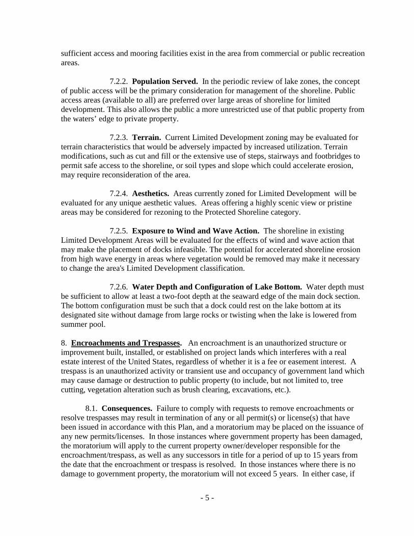
7.2.2. Population Served. In the periodic review of lake zones, the concept of public access will be the primary consideration for management of the shoreline. Public access areas (available to all) are preferred over large areas of shoreline for limited development. This also allows the public a more unrestricted use of that public property from the waters’ edge to private property. 7.2.3. Terrain. Current Limited Development zoning may be evaluated for terrain characteristics that would be adversely impacted by increased utilization. Terrain modifications, such as cut and fill or the extensive use of steps, stairways and footbridges to permit safe access to the shoreline, or soil types and slope which could accelerate erosion, may require reconsideration of the area. 7.2.4. Aesthetics. Areas currently zoned for Limited Development will be evaluated for any unique aesthetic values. Areas offering a highly scenic view or pristine areas may be considered for rezoning to the Protected Shoreline category. 7.2.5. Exposure to Wind and Wave Action. The shoreline in existing Limited Development Areas will be evaluated for the effects of wind and wave action that may make the placement of docks infeasible. The potential for accelerated shoreline erosion from high wave energy in areas where vegetation would be removed may make it necessary to change the area's Limited Development classification. 7.2.6. Water Depth and Configuration of Lake Bottom. Water depth must be sufficient to allow at least a two-foot depth at the seaward edge of the main dock section. The bottom configuration must be such that a dock could rest on the lake bottom at its designated site without damage from large rocks or twisting when the lake is lowered from summer pool. 8. Encroachments and Trespasses
. An encroachment is an unauthorized structure or improvement built, installed, or established on project lands which interferes with a real estate interest of the United States, regardless of whether it is a fee or easement interest. A trespass is an unauthorized activity or transient use and occupancy of government land which may cause damage or destruction to public property (to include, but not limited to, tree cutting, vegetation alteration such as brush clearing, excavations, etc.).
8.1. Consequences. Failure to comply with requests to remove encroachments or resolve trespasses may result in termination of any or all permit(s) or license(s) that have been issued in accordance with this Plan, and a moratorium may be placed on the issuance of any new permits/licenses. In those instances where government property has been damaged, the moratorium will apply to the current property owner/developer responsible for the encroachment/trespass, as well as any successors in title for a period of up to 15 years from the date that the encroachment or trespass is resolved. In those instances where there is no damage to government property, the moratorium will not exceed 5 years. In either case, if

- 6 -
shoreline zoning is changed during the moratorium to Protected Shoreline, a request for reinstatement of the permit/license will not be considered, and/or any previously grandfathered rights (as to location, limits, design, etc.) will be null and void and will not be reinstated. In instances where vegetation has been damaged, destroyed, altered or removed from government property, the amount of restitution and the length of the moratorium will be determined based on the International Society of Arboriculture’s (ISA) Guide for Plant Appraisal by applying the Trunk Formula Method to appraise the value of damage to government property. Other types of damages will be appraised on a case-by-case basis using the best available method. The length of the moratorium will be based on the following appraised values: Appraised Damages Length of Moratorium Less than $10,000 Up to 5 Years $10,000 - $15,000 Up to 10 Years Greater than $15,000 Up to 15 Years
8.2. Private Survey. A private survey is recommended prior to any construction
adjacent to public lands to avoid the possibility of an inadvertent encroachment.
8.3. Removal of Unauthorized Structures. Unauthorized structures may be removed by the Government in accordance with the provisions of Title 36, Chapter III, Part 327, Code of Federal Regulations, and the violator may be cited into Federal Court. The violator may be responsible for any costs incurred by the Government as a result of the removal of any unauthorized structure(s). 9. Boundary Identification
.
9.1. Corps of Engineers Actions.
9.1.1. The boundary line between government property and adjacent private property has been surveyed and marked either by concrete monuments or survey pins and boundary markers. Corps personnel periodically inspect and maintain the boundary line. The approximate location is marked by painted trees or metal placards with decals immediately adjacent to the line on either side and typically within five feet of the line.
9.1.2. Any encroachment or trespass on government fee or easement land, by an individual or organization precludes the granting of shoreline use permits and licenses. Therefore, any encroachment or trespass must be resolved prior to the granting of the permit or license. A visual inspection of government property will be part of the permit/license application process, as well as a review of government records to insure that there is no moratorium in place (See Section 8.1) that would preclude the issuance of a permit or license.

- 7 -
9.2. Landowner Actions.
9.2.1. It is the adjacent landowner’s responsibility to determine the exact location of the boundary line prior to initiating any action that might result in a trespass or encroachment upon government property. A private survey is recommended prior to any construction adjacent to public lands. While the Corps of Engineers makes a concerted effort to maintain boundary markers, adjacent landowners are responsible for verifying their own property lines before initiating any construction. Government boundary line data is available at the local Corps office and at the District office, and can be supplied for reference upon request.
9.2.2. The holders of vegetation alteration permits are required to mark the property line as specified in Section 21.7. of this Plan. Other adjacent landowners are encouraged to mark the line in a similar manner for their own benefit at no cost to the Government.
9.2.3. The placement of licensed/permitted facilities requires the precise location of common property lines. It is the applicant’s responsibility to ensure that the licensed/permitted facilities do not encroach on adjacent private property.
9.2.4. Landowners adjacent to government property who are performing logging operations or removing trees or vegetation on private property, or having this work performed for them, must be certain as to the location of the common property line in order to ensure that government trees are not removed or damaged. In the event that trees are trimmed, cut, removed, or damaged on government property, the landowner may be cited to Federal court. Activities that cause damage and/or destruction to public lands may result in termination of any or all permit(s)or license(s), and/or denial of future applications in accordance with the provisions of Section 8.1. of this Plan.
10. Flowage Easements
. Flowage easements acquired around the lake allow the Government to flood those lands and prohibit the construction of any structure, other than farm fences, without the prior written approval of the Government. That approval is given in the form of a Consent to Easement Structure, and is not governed by this Plan. Habitable structures are strictly prohibited on flowage easement lands. The restrictions on construction are necessary to prevent any actions that could interfere with the Government’s right to use the properties for flood storage. Owners of property subject to these easements are encouraged to know the boundaries of the easements and the restrictions imposed on their use of the property. Violation of the easement restrictions creates an encroachment, and it is the landowner’s responsibility to resolve any encroachment activity.
11. Shoreline Use in Limited Development Areas
.
11.1. General. All facilities on government property must be authorized by a permit, license, or other formal document. The specific types of development identified in this Plan that do not interfere with project operation may be authorized in Limited Development Areas with a permit or license. Permits and licenses may be issued only to adjacent property

- 8 -
owners, or property owners within a developed subdivision adjacent to government property, who have legal right of access to the shoreline. The Park Manager may request documentation of the right of access. Should the right of access be revoked by the grantor or lost for any reason, the permittee will immediately remove the permitted facility from government property. Applications for all structures or actions requiring a permit or license shall be submitted to the Park Manager to schedule a joint inspection of the area. If the proposed action is not acceptable under the provisions of this Plan, the request will be denied and documented in the files. If the request is acceptable, the applicant will be given instructions to complete the request. The Park Manager will process the completed application and issue the permit, or forward the completed license application to the District Real Estate Office where the license will be issued.
11.2. Compliance with Approved Plans. Anyone performing work authorized by a permit or license must be in possession of a copy of that permit/license while work is being performed. All construction on government property will be inspected to insure compliance with approved plans. When deviations from the approved plans are noted, all work will stop immediately until satisfactory measures are taken to insure that the provisions of this Plan are met. Continued noncompliance may result in the license or permit being revoked and the owner removing the structure and restoring the area to its original condition. Structures which are not removed within 30 days after written notice is provided may be impounded and/or removed by the Corps of Engineers in accordance with reference 3(16). The owner will be assessed the costs incurred by the Corps for any impoundment and/or removal. All new or reconstructed group docks will be inspected for compliance with submitted plans and specifications before being placed on the lake.
11.3. Compliance Inspections. The Park Manager will perform compliance inspections of all licensed or permitted facilities and activities. The Park Manager, or an authorized representative, will be allowed access through the permittee’s or licensee’s property to conduct these inspections. The instrument holder will correct non-compliance with the license or permit provisions.
11.4. Renewals. Although courtesy renewal reminders are mailed prior to expiration of the permit/license, renewal is the responsibility of the permittee/licensee at no cost to the Government. It is imperative that permit and/or license holders take appropriate action to renew their permit(s) and/or license(s) before the term expires. Regardless of when the permit/license is renewed, the term of the new permit/license will begin the day following expiration of the expiring permit/license to insure no shortening of the original term. HOWEVER, if a permit or license is not renewed within 30 days of its expiration, the permitted or licensed facility becomes an unauthorized structure and will be treated as an encroachment, in accordance with the provisions of Section 8 of this Plan, and the permittee and/or licensee may be denied a new permit/license for up to five (5) years.
11.5. Transfer of Licenses/Permits. Permits and licenses are not transferable except as noted below. Upon the sale or other transfer of the permitted/licensed facility or the death of the permittee/licensee and his/her legal spouse, the permit or license is null and void. When the permit holder for a group dock having multiple members relinquishes his/her
- 9 -
interest in the group dock, the permit will be reissued in the name of another member of the group dock without assessing an additional fee.
11.6. Grandfathered Facilities.
11.6.1. As noted throughout this Plan, some existing permits and licenses have been exempted from the current requirements to recognize commitments made in previous shoreline management plans. Conditions that apply to those particular grandfathered facilities are included in the sections of this Plan that deal with each particular type of facility.
11.6.2. Additionally, there are a limited number of group docks (and related permits and licenses) in areas rezoned from Limited Development to Protected Shoreline at Rough River Lake. Conditions that apply to those facilities at Rough River Lake are discussed in Section 26.
11.7. Appeal Rights.
11.7.1. The District Commander or his/her designee may revoke any permit when it is determined that the public interest requires such revocation or when the permittee fails to comply with the terms and conditions of the permit. The permittee will be notified by certified letter.
11.7.2. The Park Manager may deny a permit application when the applicant does not meet the eligibility requirements set forth in this Plan, or if the permit would violate the conditions set forth in this Plan.
11.7.3. In either case, the applicant or permittee will be allowed a 30-day period from the date of notification to submit an appeal request in writing to the Park Manager. The Park Manager will review the appeal request and forward for review by the Operations Manager for the Green River Area. The Operations Manager will make a decision on the appeal, and notify the applicant or permittee by certified letter.
11.7.4. If the applicant chooses to contest the decision of the Operations Manager a second appeal may be submitted within 15 days of notification to the Operations Manager for forwarding to the District Office for review. Following the final District Office review, a written decision will be mailed to the person making the appeal by certified letter.
11.7.5. The terms for revocation of a license are addressed in the license document and are coordinated with the Real Estate Division.
11.8. Prohibited Items or Activities. The following is a list of items or activities that are prohibited on government property, but is not intended to be all inclusive.
- 10 -
11.8.1. Items:
(1) Flower, plant, or vegetable gardens.
(2) Formal arrangements of hedges and shrubs. (3) Swings, picnic tables, signs, patios, etc. (4) Boat houses. (5) Piers or jetties. (6) Marking buoys. (7) Buildings or any structure not covered by a permit, license/lease. (8) Sewage lines or related structures. (9) A well or spring development. (10) Fences (except farm fences on the property line). The adjacent land owner erecting the fence is responsible for determining the exact location of the property line, which may require a professional survey. (11) Anchor posts or devices such as fenders, bumpers, tires, logs, etc. (12) Garbage, debris or refuse dumps or garbage pickup points (unless covered by a license or lease). (13) Fuel tanks or other fuel storage containers. (14) Chairs, tables, umbrellas, and/or carpet may not be left on government property or on docks unless in use at the time. If not in use, they must be kept on boats, in an approved storage cabinet on the dock, or removed from government property. No permanent mounting of items of this type. (15) Diving boards, rope swings, (or similar devices). (16) Any other structures, items, or equipment on docks or land not specifically approved by permit or license. (17) Inflatable Items moored around docks or on government property (i.e., water trampolines, tubes, floating toys, floating platforms, floating diving platforms, other water toys not described here). Items must be placed on boats, in an approved storage cabinet on the dock, or removed from government property when not in immediate use.
- 11 -
(18) Planting of any herb, grass, shrub or tree not native to the county in which the property lies. (19) Zip lines, swings or any other item attached to or going through or over government property.
11.8.2. Activities: (1) Painting or whitewashing of any tree trunk, boulder, rock outcrop, stump or other feature. (2) Alteration of the natural terrain by making cuts or fills, unless in conjunction with the construction of a licensed or permitted facility. (3) Ranging, grazing, watering or allowing livestock on project lands. (4) Brush clearing, tree cutting, or any type of vegetation removal (unless specifically authorized by permit or license).
11.8.3. Environmental / Cultural Issues:
(1) Excavation or disturbance of an archaeological site, or the removal of an artifact. (2) Metal detector use and digging activities related to metal detector use is prohibited (without written permission from the District Engineer, or authorized representative) except as permitted in Title 36, Chapter III, Section 327 CFR. (3) Use of herbicides or pesticides for vegetative, animal, or insect control. (4) Use of soaps, solvents, cleaners, strippers, or mechanical processes (such as sanders, grinders, or power washers) that result in chemical, particle, or other materials/pollutants being deposited on government land or water. (5) Disturbance of any environmental feature, animal home, wildlife habitat, fishery habitat, or other environmental feature not described here. 12. Licenses
. Licenses are issued by the Louisville District’s Real Estate Division and authorize the placement, use, and maintenance of land based facilities.
12.1. Encroachment or Trespass. A visual inspection of government property will be part of the license application process. Any encroachment or trespass on government fee or easement property by an individual or organization precludes the granting of a shoreline
- 12 -
use license. Therefore, any encroachment or trespass must be resolved prior to the granting of a license. In certain instances where an encroachment or trespass has resulted in damage to government property a moratorium may be placed, or may already be in effect, on the issuance of any new permits/licenses in accordance with Section 8.1. of this Plan.
12.2. Fees.
12.2.1. License fees are collected for improved pedestrian access (i.e., cart paths, footpaths, etc.), grandfathered electrical service, existing water lines, grandfathered boat ramps, etc. License fees are based on the fair market value and the administrative cost of processing and administering the license. License fees are reviewed annually and are subject to change as the market values and/or administrative costs change. Current license fees will be provided by the Park Managers upon request. All license fees will be paid in advance. Cash will not be accepted. Licenses are not transferable and no refunds will be made if the licensee terminates the license before the expiration date. A refund may be issued if the Government terminates the license through no fault of the licensee. 12.2.2. The benefit to the public for ramps and appurtenant structures that are open to the public is reflected in the appraised market value for the license. Ramps that are not open to the public are appraised on the basis of a “private” ramp facility, which results in a higher market value. The administrative costs for public and private ramps are the same.
12.3. Conditions. The conditions for licenses are found in the license instrument. The licensee agrees to abide by those conditions upon acceptance of a license, and failure to do so will result in termination of the license. Upon termination of any license, the licensee is required to remove all improvements and restore the premises to the satisfaction of the Park Manager. Failure to do so results in an unauthorized structure that will be resolved in accordance with the provisions of Title 36 cited above in Section 8.3. of this Plan. 13. Water Lines and Water Withdrawal (license)
. Grandfathered licenses for water lines and/or water withdrawal for domestic use will be authorized for current and subsequent owners until a public water supply becomes available. No new licenses for water lines and/or water withdrawal will be issued. The withdrawal of water for irrigation is not permitted under this Plan. The Corps may issue temporary water withdrawal agreements during periods of drought, but these agreements are not regulated in this Plan.
14. Improved Pedestrian Access (license)
. Improved footpaths, cart paths and incline elevators or similar devices for disabled access, footbridges, stairways, and steps are designated as improved pedestrian access facilities, and may be authorized for access to permitted boat dock facilities in Limited Development Areas. A limited number of grandfathered group docks remain in areas that were rezoned from Limited Development to Protected Shoreline at Rough River Lake. Special considerations to accommodate access to those grandfathered docks are specified in Section 26.4.

- 13 -
14.1. Purpose and Scope. The structures will be approved only where necessary to provide access to a permitted boat dock, and will not be authorized for landscaping or ornamental purposes. Nor will they be allowed over gentle terrain presenting no major obstacles to foot traffic, with the exception of improvements that are needed to provide disabled access. Staircases will not be permitted over cliffs or bluffs that are near vertical. Safety and environmental concerns will be considered prior to issuing any license.
14.2 Grandfathered Facilities. Existing or previously approved facilities that do
not meet the structural guidelines in this Plan will be grandfathered to current and future owners as long as they are properly maintained. Should the licensee fail to properly maintain the structure, the structure will be replaced with an approved structure meeting current standards and complying with current policy, or the structure will be removed and the area restored by the current licensee in accordance with the conditions in the license.
14.3. Limits and Shared Access Requirements.
14.3.1. This Plan specifies limits on the allowable length for each type of
improved pedestrian access. Exceptions to those limits may be considered on a case-by-case basis, provided there is minimal change to the limits to allow reasonable access to an authorized group dock, and no other provisions or requirements of this Plan are violated.
14.3.2. It is the Government’s intent to limit the number of pathways to the greatest extent possible to minimize the impacts on natural resources. In areas where more than one adjacent property owner has applied for an improved pedestrian access license, joint use of a new or existing pathway will be required to the greatest extent possible. A 3’ minimum opening may be required on all improved pathways, stairs, and steps with handrails to allow property owners access from either side, at a point(s) approved by the Park Manager. If necessary to insure safe access, the Park Manger may also require an appropriate landing. Licensees cannot restrict use of that portion of a licensed facility located on government property.
14.4. Eligibility.
14.4.1. Improved Access. Applicants must own property in a developed subdivision which is adjacent to government property, or own a tract of land which adjoins government property. Owners of interior lots that are not adjacent to government property must have legal right of access through a documented public access area. Each qualifying lot owner/household will be limited to one license for improving access to a permitted boat dock at each lake.
14.4.2 Mobility Impairment Access. If an eligible applicant or a member of their household has a permanent impairment that limits mobility, the applicant may apply for an upgrade to a footpath to accommodate use of a wheel chair, or a cart path for disabled access. The applicant must submit written certification, in a format acceptable to the Park Manager, that documents the existence of a permanent mobility impairment affecting the applicant or a member of their household. Owners of interior lots, not adjacent to
- 14 -
government property, must utilize legal access through a documented public access easement if it is available within 500’ of the permitted dock facility. If legal access through a documented public access area is not available within 500’, the applicant may utilize legal access across private property, but must provide a notarized letter of permission from the landowner. When ownership of the private property is transferred, the licensee must obtain a notarized letter of permission from the new landowner. Should the license holder lose right of access across private property, the license will be terminated, and licensee must remove the access improvement and restore government property to the satisfaction of the Park Manager. Each qualifying lot owner/household will be limited to one license for improving access to a permitted boat dock at each lake.
14.5. Improved Footpaths.
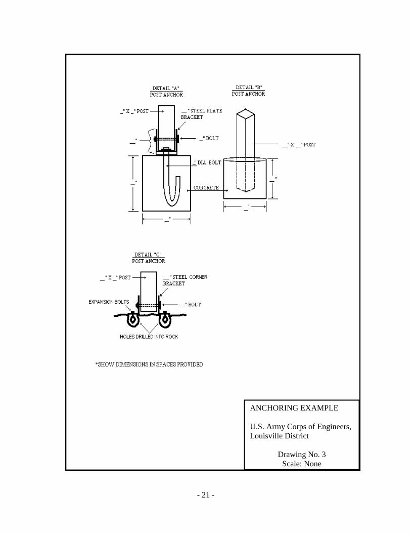
14.5.1. Improved footpaths shall not exceed four feet in width, with a combined length of pathways, stairways, landings and steps not to exceed 500 feet in length. Pathways may be covered with creek gravel, crushed stone, tan bark, wood chips, stepping stones or other readily removable material. Asphalt, concrete, or other permanent surfacing will not be used. At the licensee's option, pre-treated lumber or naturally-colored composite lumber may be used to edge the path and confine the covering material, although the timbers must be securely anchored to prevent floating. No significant alteration (over 6 inch cut and fill) will be permitted for a footpath. The slope of the path should be held to a minimum through the use of switchbacks to reduce erosion damage.
14.5.2. Pre-treated 4” x 4” timbers (minimum), cast paving blocks, naturally- colored composite lumber, or natural stones should be used as steps where possible in lieu of a staircase. Use of these alternative materials in place of a staircase is encouraged in order to minimize the environmental and visual impact of the licensed facility.
14.5.3. If the applicant or a member of their household has a documented permanent disability that limits mobility over unconsolidated materials, the path surface may be constructed of materials approved by the Park Manager that are suitable for wheelchair access.
14.6. Cart Paths.
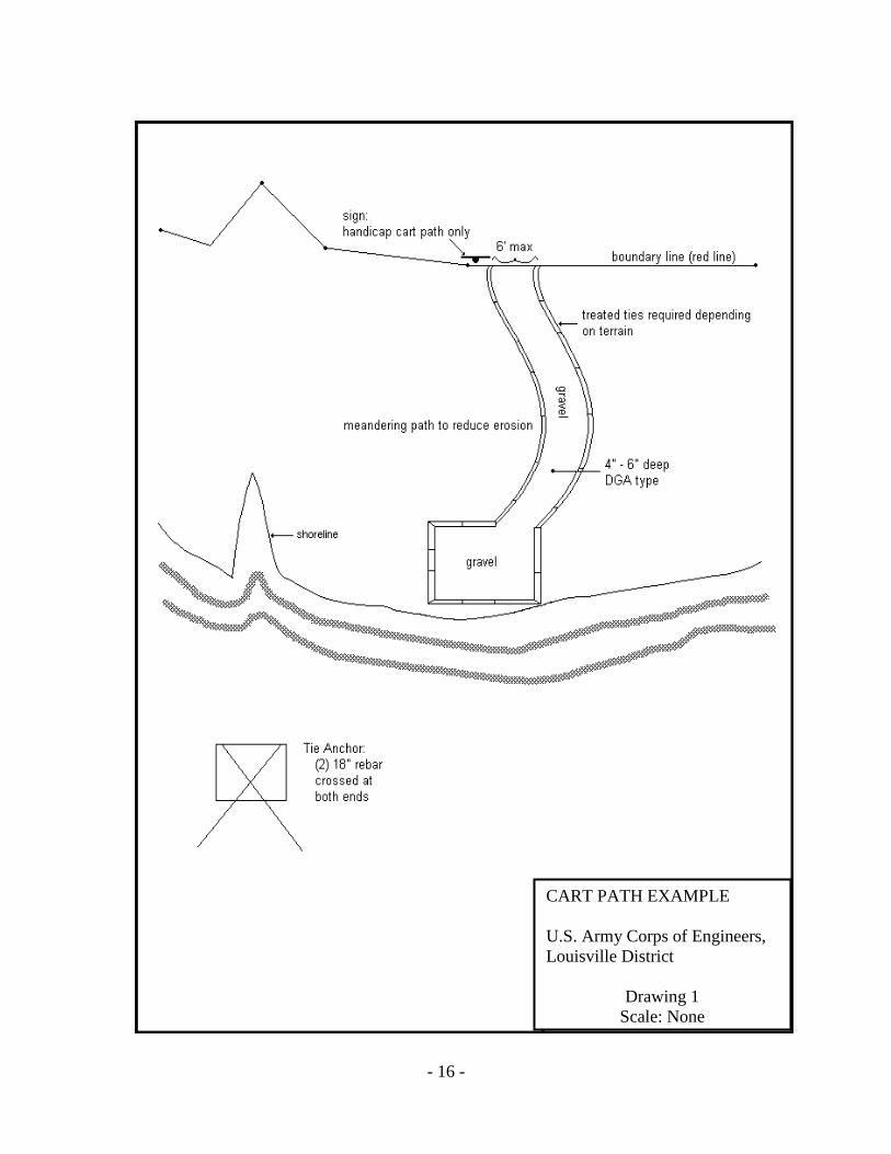
14.6.1. The surface, layout, and construction will minimize erosion and
comply with the plan approved with the license application. Drawing No. 1 on page 16 is an example of a cart path which can be used for developing site specific plans to be submitted with the license application. Cut and fill will not exceed 12 inches unless small culverts are approved for crossing ditches. The Park Manager may require the placement of gravel or other erosion control measures where needed to protect natural resources and to insure stability of the cart path. If timber borders are used, they must be secured to prevent floating. A small turnaround may be constructed at the end of the path. The maximum length of the cart path is 500 feet, or to the nearest dock location, whichever distance is shorter, with a maximum width of 6 feet.
- 15 -
14.6.2. Authorized conveyances may be used to transport the individual with the documented mobility impairment and for activities directly associated with that individual’s use of permitted or licensed facilities. Only golf carts, riding lawnmowers and similar low speed conveyances may be used. Authorized conveyances must display a sticker issued by the Corps of Engineers. All terrain vehicles, motorcycles, and/or vehicles licensed for highway use are prohibited. Since the tremendous variety of available conveyances cannot be listed here, permission to use conveyances other than golf carts and riding mowers must be obtained from the Park Manager.
14.6.3. Operation is allowed only on the approved path, and violators may be cited to Federal court. Licenses for cart paths may be revoked if they are not used in accordance with these provisions. Revoked licenses will not be eligible for reinstatement for a period of up to five years.
- 16 -
CART PATH EXAMPLE U.S. Army Corps of Engineers, Louisville District
Drawing 1 Scale: None
- 17 -
14.7 Incline Elevators and Similar Devices. Requests will be considered on a case-by-case basis, and allowed only where the terrain will not accommodate the use of a cart path and a low speed conveyance vehicle for disabled access. Installation will be accomplished in such a manner to minimize erosion and will comply with the plan approved with the license application.
14.7.1 The overall length of tracks and landings will be limited to 500 linear feet, or to the nearest dock location, whichever distance is shorter. Tracks and/or the supporting structure for the device will not extend more than two (2) feet above ground. The maximum width of the entire device will not exceed four (4) feet. 14.7.2 The approved unit must blend with the natural surroundings to the greatest extent possible. The rail system may be galvanized or painted. The carriage and landing gates will be painted. Paint colors are limited to brown or muted green that will blend with the natural surroundings. The park manager may make exceptions to this requirement if painting of an individual component would violate the manufacturer’s warranty. 14.7.3 Cut and/or fill will not exceed 12 inches unless small culverts are approved for crossing of ditches.
14.7.4 Only devices designed and manufactured for such use will be considered, and an annual inspection report provided by the manufacturer or a licensed mechanical engineer will be required to certify that the device and electrical service is properly maintained and safe for use.
14.7.5 All electrical connections must be made above the designated flood pool elevation. Solar power may be used as an alternative.
14.7.6 The Park Manager will designate a location for such a device that results in the least impact on the environment and natural resources. In no event will tracked or heavy equipment be allowed on Government property for the purpose of installing such a device. The Park Manager may require the placement of gravel or other erosion control measures where needed to protect natural resources and to insure stability of the device.
14.8. Footbridges. Footbridges may be authorized to traverse ditches or
ravines that impede access to the shoreline or a dock. Bridges will not be authorized solely for ornamental or landscaping purposes. Bridges will be constructed of wood that has been treated with a preservative that is not harmful to the environment. As an alternative, composite decking may be used on the walkways and railings. However, additional bracing may be required in accordance with manufacturer’s recommendations. Bridges will not be painted, but a clear sealer may be applied to wood components. Structures will be firmly anchored to prevent flotation. Trees will not be used for anchoring devices or as any part of the structure. Footbridges will not exceed 14 feet in length.

- 18 -
14.9. Stairways and Steps. Drawings 2, 3, and 4 on pages 20 - 22 contain examples
of stairway features which can be used for developing site specific plans to be submitted with the license application. When steps have been authorized, they should be angled or designed in an offset configuration to blend with the terrain and minimize erosion damage. The overall length of steps is to be minimized, and shall not exceed 100 feet. Steps are to be built as close to the ground as possible. In general, height of landings will not exceed 18 inches above ground level. Design of staircases should be made in accordance with the following Dimensions and Material specifications, and construction of stairways and steps must comply with all applicable building codes.
14.9.1. Dimensions.
Stringers for Steps. 2" x 12"
Step Treads. 2" x 12", two 2" x 6", or three 2” x 4”
Step Riser. Minimum 4” and Maximum 7”
Landing Platform. No greater than 4' x 6' with 2" x 10" joists
and 2" x 6" decking or greater. Cross support joists to be on 2’ centers. Landings should not be greater than 18 inches in height, in general, as measured from ground level to the base of the landing.
Columns/Post for Support and Handrails. 4" x 4" if under a 12' run 6" x 6" (or 6" - 8" pole) if over a 12' run
Handrails. 42" high above stair treads/decking with 2" x 4" railing if posts are greater than 6’ apart. Greater spacing of posts requires 2” x 6” railing with 2” x 4” supplemental railing attached under the 2” x 6” at top of post.
Guardrails. 2" x 4" or greater guardrail 20" above steps/decking.
Hardware. Fasteners and fittings acceptable for use with pressure-
treated lumber shall be used.
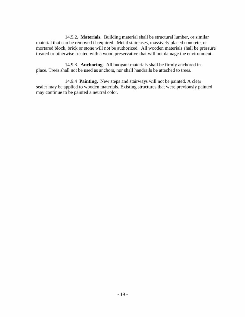
Concrete Anchors. Secure anchors are required for all columns/posts; however, anchors shall be kept flush with ground level. Posts may be secured either by a 1/4" steel bracket or by placement directly into the concrete.
Width. Staircases are to be 3’ to 4’ in width. Staircases exceeding
3 feet in width require a center stringer.
- 19 -
14.9.2. Materials. Building material shall be structural lumber, or similar
material that can be removed if required. Metal staircases, massively placed concrete, or mortared block, brick or stone will not be authorized. All wooden materials shall be pressure treated or otherwise treated with a wood preservative that will not damage the environment.
14.9.3. Anchoring. All buoyant materials shall be firmly anchored in place. Trees shall not be used as anchors, nor shall handrails be attached to trees.
14.9.4 Painting. New steps and stairways will not be painted. A clear
sealer may be applied to wooden materials. Existing structures that were previously painted may continue to be painted a neutral color.

- 20 -
STEP PLAN U.S. Army Corps of Engineers, Louisville District
Drawing No. 2 Scale: None
- 21 -
ANCHORING EXAMPLE U.S. Army Corps of Engineers, Louisville District
Drawing No. 3 Scale: None
- 22 -
4’
FOOT PATH U.S. Army Corps of Engineers, Louisville District
Drawing 4 Scale: None

- 23 -
15. Roadways, Turnarounds, Parking Areas and Ramps (license)
. Applications for licenses to construct new access boat ramps, roads, parking areas, and turnarounds will not be considered under this Plan. Licenses for existing roadways, turnarounds, parking areas and ramps will be grandfathered to the current licensee and his/her successors for as long as the facilities are safely maintained. Improvements to these grandfathered facilities will be considered on a case-by-case basis to address safety and environmental issues. The following design standards and special considerations, and Drawing No. 5 on page 24, are applicable to the maintenance and continued use of grandfathered ramps, roads, parking lots, and turnarounds.
15.1. Ramps:
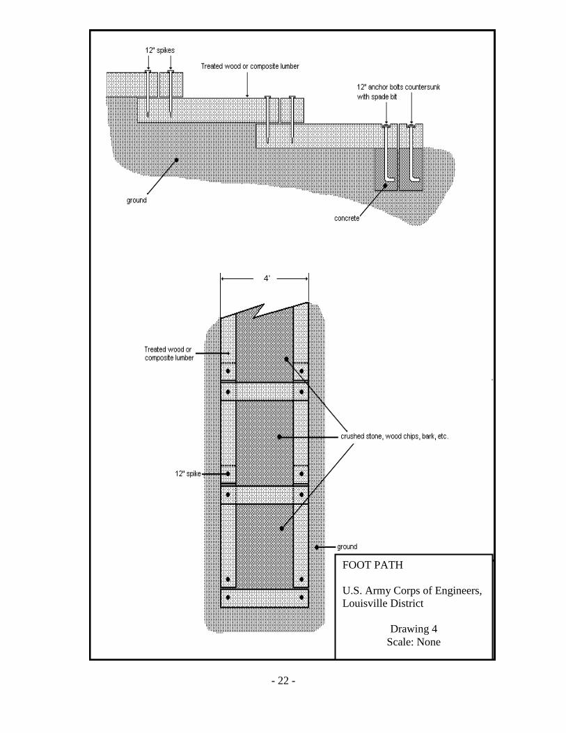
15.1.1. Ramp shall have six inches of 3000-psi concrete over a minimum of four inches of crushed limestone.
15.1.2. Ramp will extend a minimum of five feet vertically above and five feet vertically below summer pool.
15.1.3. Slope of the ramp must be not less than 12% or more than 15%, and must be uniform for the entire length.
15.1.4. Minimum width of the ramp will be 12 feet.
15.1.5. Concrete slab and end sections will be reinforced as shown in Drawing No. 5. on page 23. Size and quantity of steel are as follows: Fourteen #3 bars - three feet long
Two #6 bars - 12 feet long 6 x 6 – W1.4 x W1.4 welded wire fabric that is 12+ feet wide
and the length of the slab.
15.1.6. Contraction and expansion joints shall be installed as shown in Drawing No. 5 on page 23.
15.1.7. Surface of the ramp shall have a broom finish with a rough surface to increase the traction of the launching vehicle.
15.1.8. Edges and seaward end of the ramp will be protected with Class II channel liner to prevent undermining of the slab. Stone shall be placed a minimum of two feet wide around the perimeter of the ramp and to a minimum of six inches deep. Unsafe conditions, such as undermining of the concrete, may result in termination of the license.
- 24 -
OPTIMUM GRA
RAMP SPECIFICATIONS U.S. Army Corps of Engineers, Louisville District
Drawing No. 5 Scale: None

- 25 -
15.2. Roads.
15.2.1. Roadways will be surfaced with crushed stone or creek gravel. No asphalt or concrete will be used. Existing roadways constructed of concrete materials may remain through their useful life, but cannot be resurfaced.
15.2.2. Roadway width shall be 12 feet. The right-of-way or disturbed area shall not exceed 18 feet in width. Drainage structures will be permitted where required.
15.2.3. Roadways will follow the natural contour of the land to the maximum extent possible. Cuts or fills in excess of 18 inches will not be permitted except to install drainage structures.
15.3. Parking Areas and Turnarounds.
15.3.1. Surface of parking lots and turnarounds will be crushed stone or creek gravel.
15.3.2. Turnarounds shall have a minimum radius of 40 feet measured from the centerline of the ramp road.
15.3.3. Ramp parking lots shall be of sufficient width to accommodate a vehicle and a boat trailer without interference with the launching of a boat or the use of the turnaround.
15.4. Special Considerations.
15.4.1. Commercial Activities. No commercial operations will be conducted at any licensed ramp, road, parking area or turnaround. No launch fees or use fees will be collected unless the District Commander gives specific authorization.
15.4.2. Vegetation Alteration. A shoreline use permit may be issued to the licensee of a boat ramp and/or turnaround, and/or parking area along with any associated road on government property to trim vegetation in this area. The mowing area shall be a ten foot maximum strip (ten feet on each side of road, etc.) along the edges of these areas. Vegetation alteration includes removing selected trees, underbrush, or driftwood, trimming, pruning, and mowing. Prior to the removal of any vegetation, the permittee shall meet with a Corps Ranger who will outline the limits of the permit area and designate certain trees or stems that must be left in the permit area. The Ranger will attempt to leave a minimum of one tree or viable stem for each ten feet square (100 square feet). Clear cutting will not be allowed. Trees larger than 3” in diameter at ground level will not be cut unless dead, diseased, or damaged and approved for cutting. Existing boat ramp licensees shall contact the local Corps office to obtain this permit before any mowing is conducted along existing facilities. The fee for this permit is in addition to that charged for the license.
- 26 -
15.4.3. Although permits will normally be for five years, permits of varying
length (whole year only) may be issued for administrative reasons. The expiration date of the permit will be a whole year multiple from the anniversary date of the initial issue.
15.4.4. Garbage Removal. Licensee shall be responsible for collecting and properly disposing of all garbage and debris deposited on the licensed facility, regardless of the source.
15.4.5. Signs. Licensee shall provide and maintain such signs as the
Corps of Engineers deems necessary to provide for public safety on ramps and roadways leading to the water. 16. Grandfathered Electrical Use (license)
. The continued upkeep of existing land based electrical service to authorized facilities on fee land is granted under the provisions of a grandfathered license. Corps of Engineers personnel will periodically inspect to assure that facilities are properly maintained in compliance with these conditions, and the Park Manager will require the immediate upgrade or removal of any electrical service that is not certified, does not meet code, or is not safely maintained. Existing electrical service may be allowed to remain for the lifetime of the licensee or his/her spouse provided all other conditions are met. Upon change of ownership, the licensee must remove all electrical service from government property. All grandfathered electrical service is subject to the following conditions:
16.1. Safety and Interference. The service shall pose no safety hazard to any individual nor interfere with any aspect of project operations. Grandfathered service to group docks will be by drop cord only, and cords will be removed when not in immediate use.
16.2. Electric Codes. All electrical service must conform to the National Electrical Code, the National Electrical Safety Code and all other applicable state and local codes and regulations.
16.3. Inspections. All electrical service must be inspected and approved by a State of Kentucky certified inspector. Proof of compliance shall be provided to the Park Manager every five (5) years, with the next certification due five (5) years from the date of the last renewal of the license and before the license is renewed.
16.4. Ground Fault Interrupters. All electrical circuits that extend onto government property must have a properly operating ground fault interrupter (GFI) installed above the maximum flood pool elevation. Failure to provide or maintain the GFI in proper working condition may result in revocation of the license. The GFI shall be maintained on a post or on the exterior of a building in plain view where it is readily accessible, and shall be approximately 5 feet above the ground. Licensees are required to turn off the power at the GFI’s and lock-out access when not in use.
- 27 -
16.5. Wire. All permanently installed electrical wiring extending onto government property shall be buried to the depth required by the referenced codes, except that the option of encasement in concrete is not allowed. The location of the cable or conduit shall be marked with warning tape buried at a depth of 9 - 12 inches above the electric wire. Underground wiring must be direct burial type (UF or USE) which can be installed without conduit, or THW or equal standard wiring installed in non-metallic conduit. Other wiring suitable for wet or submerged locations may also be appropriate.
16.6. Conduit and Boxes. All above ground wiring shall be maintained
in an approved electrical conduit. All enclosures such as breaker boxes, switch boxes, and receptacles shall be rain-tight and weather resistant, and shall be maintained on a securely mounted treated wooden post or pole a minimum of 5 feet above the ground.
16.7. Security Lights. Existing security lights shall be maintained on treated
wooden posts or poles not less than 12 feet above the base of the pole. The height of the light bulb shall not be lower than the calculated five-year flood pool, which can be obtained at the applicable project office. Lights or wiring to lights shall not be installed on trees. New requests for the addition of security lights to existing electrical service, or any other type of lighting, on government property, or on a permitted or licensed facility under this Plan, will be reviewed on a case-by-case basis. All new lighting and/or replacements of grandfathered lighting shall have directional shielding that prevents loss of light skyward or across the lake beyond the immediate vicinity of the permitted or licensed facility.
16.8. Convenience Outlets. Convenience outlets may be allowed to be maintained
adjacent to group docks under the provisions of a grandfathered license. Temporary drop cords extending onto government land, used in conjunction with a grandfathered license for electrical service are subject to these same conditions, and must have prior Corps approval. Drop cords not in use will immediately be disconnected and removed from government land. New requests for the addition of convenience outlets to existing electrical service will not be authorized. 17. Permits
. Permits are issued by the Park Manager for the placement, use, and maintenance of floating facilities, vegetation alteration, unimproved paths, and for specified acts that are necessary and unique.
17.1. Encroachment or Trespass. A visual inspection of government property will be part of the permit application process. Any encroachment or trespass on government fee or easement property by an individual or organization precludes the granting of a shoreline use permit. Therefore, any encroachment or trespass must be resolved prior to the granting of a permit. In certain instances where an encroachment or trespass has resulted in damage to government property, a moratorium may be placed, or may already be in effect, on the issuance of any new permits in accordance with Section 8.1.of this Plan.
17.2. Fees. Permit fees are collected for boat docks and vegetation alteration to cover the costs incurred by the Corps to process the permit and to inspect the permitted

- 28 -
facility/area. These fees are established by Headquarters, U. S. Army Corps of Engineers and are uniform for all civil works projects under the jurisdiction of the Corps. Fee Schedules are subject to periodic revision. Current fee schedules can be obtained at the Corps’ project offices. All permit fees will be paid in advance. Cash will not be accepted. Permits are not transferable and no refunds will be made if the permittee terminates the permit before the expiration date. A refund may be issued if the Government terminates the permit through no fault of the permittee.
17.3. Conditions. The standard conditions for shoreline permits are stated below, and the permittee agrees to abide by these conditions upon acceptance of a permit. The permit conditions are enforceable through Title 36, Chapter III, Part 327, Code of Federal Regulations. Violations of this regulation may be punishable by a fine of not more than $5000 and/or imprisonment of not more than 6 months. The Park Manager may require additional restrictions on a permit based on site specific conditions.
(1) This permit is granted solely to the applicant for the purpose described on the attached permit.
(2) The permittee agrees to and does hereby release and agree to save and hold the Government harmless from any and all causes of action, suits at law or equity or claims or demands or from any liability of any nature whatsoever for or on account or any damages to persons or property, including a permitted facility, growing out of the ownership, construction operation or maintenance by the permittee of the permitted facilities and/or activities.
(3) Ownership, construction, operation, use and maintenance of a permitted facility are subject to the Government's navigation servitude.
(4) No attempt shall be made by the permittee to forbid the full and free use by the public of all public waters and/or lands at or adjacent to the permitted facility or to unreasonably interfere with any authorized project purposes, including navigation in connection with the ownership, construction, operation or maintenance of a permitted facility and/or activity.
(5) The permittee agrees that if subsequent operations by the Government require an alteration in the location of a permitted facility and/or activity or if in the opinion of the District Commander a permitted facility and/or activity shall cause unreasonable obstruction to navigation or that the public interest so requires, the permittee shall be required, upon written notice from the District Commander to remove, alter, or relocate the permitted facility, without expense to the Government.
(6) The Government shall in no case be liable for any damage or injury to a permitted facility which may be caused by or result from subsequent operations undertaken by the Government for the improvement of navigation or for other lawful purposes, and no claims or right to compensation shall accrue from any such damage. This includes any damage that may occur to private property if a facility is removed for noncompliance with the conditions of permit.

- 29 -
(7) Ownership, construction, operation, use and maintenance of a
permitted facility and/or activity are subject to all applicable Federal, state and local laws and regulations. Failure to abide by these applicable laws and regulations may be cause for revocation of the permit.
(8) This permit does not convey any property rights either in real estate or material; and does not authorize any injury to private property or invasion of private rights or any infringement of Federal, state or local laws or regulations, nor does it obviate the necessity of obtaining state or local assent required by law for the construction, operation, use or maintenance of a permitted facility and/or activity.
(9) The permittee agrees to construct the facility within the time limit agreed to on the permit issuance date. The permit shall become null and void if construction is not completed within that period. Further, the permittee agrees to operate and maintain any permitted facility and/or activity in a manner so as to provide safety, minimize any adverse impact on fish and wildlife habitat, natural, environmental, or cultural resources values and in a manner so as to minimize the degradation of water quality.
(10) The permittee shall remove a permitted facility within 30 days, at his/her expense, and restore the waterway and lands to a condition accepted by the Park Manager upon termination or revocation of this permit or if the permittee ceases to use, operate or maintain a permitted facility and/or activity. If the permittee fails to satisfy the Park Manager, the District Commander may remove the facility by contract or otherwise and the permittee agrees to pay all costs incurred thereof. (11) Facilities granted under this permit will not be leased, rented, sublet or otherwise used in the course of any commercial activity by the permittee or his/her agent for monetary gain. The use of a permitted group boat dock by individuals renting lake property constitutes unauthorized commercial activity. The use of the dock facility is intended for the mooring of the permittee’s vessel or watercraft. Such use includes the storage of gear essential to the operation of such vessel or watercraft in enclosed locker facilities.
(12) Neither a permitted facility nor any houseboat, cabin cruiser, or other vessel moored thereto shall be used as a place of habitation or as a full or part-time residence or in any manner which gives the appearance of converting the public property, on which the facility is located, to private use.
(13) The floatation material for slips shall be fabricated of materials manufactured for marine use. Floatation materials shall be 100% warranted for a minimum of 8 years against sinking, becoming waterlogged, cracking, peeling, fragmenting or losing beads. All floatation shall resist puncture and penetration and shall not be subject to damage by animals under normal conditions for the area. Floatation material shall be fire resistant. Floatation material, which is within 40 feet of a line carrying fuel, shall be 100% impervious to water and fuel. New or recycled plastic or metal drums or non-compartmentalized air containers are prohibited. Existing floatation will be authorized until it has severely

- 30 -
deteriorated and is no longer serviceable or capable of supporting the structure, at which time it shall be replaced with approved floatation. For any floatation installed after the effective date of this specification, repair or replacement shall be required when it no longer performs its designated function or fails to meet the specifications for which it was originally warranted.
(14) Permitted facilities and activities are subject to periodic inspection by authorized Corps representatives. The Park Manager will notify the permittee of any deficiencies and together establish a schedule for their correction. No deviation or changes from approved plans will be allowed without prior written approval of the Park Manager.
(15) Floating facilities shall be securely attached to the shore in accordance with the approved plans with moorings that do not obstruct general public use of the shoreline or adversely affect the natural terrain or vegetation. Anchoring to vegetation is prohibited. Every attempt should be made to route anchor cables to avoid trees. If that is not possible, a protective coating or rubber hose shall be placed on the cable to prevent damage. Anchoring and winch devices will be kept at ground level.
(16) The permit display tag shall be posted on the permitted facility and/or on the land areas covered by the permit so that it can be visually checked with ease in accordance with instructions provided by the Park Manager.
(17) No vegetation other than that prescribed in the permit will be damaged, destroyed or removed. No vegetation of any kind will be planted, other than that specifically prescribed in the permit.
(18) This permit authorizes no change in landform such as grading, excavation or filling.
(19) This permit is non-transferable. Upon the sale or other transfer of the permitted facility or the death of the permittee and his/her legal spouse, this permit is null and void.
(20) By 30 days written notice, mailed to the permittee by certified letter, the District Commander or his/her designee may revoke this permit whenever the public interest necessitates such revocation or when the permittee fails to comply with any permit condition or term. The revocation notice shall specify the reasons for such action. If the permittee requests a hearing in writing to the District Commander through the Park Manager within the 30 day period, the District Commander shall grant such hearing at the earliest opportunity. In no event shall the hearing date be more than 60 days from the date of the hearing request. Following the hearing, a written decision will be rendered and a copy mailed to the permittee by certified letter.
(21) Notwithstanding the condition cited in Section 17.3 (20) above, if in the opinion of the District Commander, emergency circumstances dictate otherwise, the District Commander may summarily revoke the permit.

- 31 -
(22) The Park Manager or his/her authorized representative shall be
allowed to cross the permittee's property, as necessary, to inspect facilities and/or activities under permit.
(23) When vegetation modification is allowed, the permittee will mark the government property line in a clear, but unobtrusive manner approved by the Park Manager and in accordance with this Plan.
(24) If the ownership of a permitted facility is sold, the permittee or new owner will notify the Park Manager of the action prior to finalization. The new owner must apply for a Shoreline Use Permit within a reasonable time period or the permittee must remove the facility and restore the use area.
(25) If permitted facilities are removed for storage or extensive maintenance, the Park Manager may require all portions of the facility to be removed from public property.
(26) The District Commander or his/her authorized representative may place special conditions on the permit when deemed necessary. Requests for waivers of Shoreline Management Plan permit conditions based on health conditions will be reviewed on a case- by-case basis by the Operations Manager. Effort will be made to reduce onerous requirements when a limiting health condition is obvious or when an applicant provides a doctor's certification of need for conditions which are not obvious.
(27) Boats shall not be left dry docked in permitted boat docks over the winter. It is the responsibility of permit holders to remove boats from their permitted boat docks before water levels become too low to accomplish removal of boats from the lake.
(28) Personal information pertaining to permit applicants/holders is protected under the Privacy Act of 1974, and the Government does not share this information without an individual’s permission. However, the designated Point of Contact (POC) for each group dock is responsible for dissemination of information to members within that group that impacts permit renewals and the continued viability of the group dock. In order to facilitate that exchange of information, each permit applicant/holder agrees to allow the Government to provide his/her basic information (name, address, and phone number) to the designated POC for his/her group dock.

- 32 -
(29) The main dock section of a slip is a component of the
comprehensive group dock and is used by other dock members and their guests as access to their individual slips. A slip owner cannot restrict use of the walkway or main dock section of a slip by other dock members.
17.4. Permit Revocation.
17.4.1 The Park Manager may revoke any permit issued and require restoration of the area to the Corps’ satisfaction if the permittee has exceeded the authorized scope of the permit.
17.4.2 The Park Manager may revoke any permit when significant
environmental degradation has occurred in the area. Environmental degradation includes the presence of zebra mussels on a dock facility or any vessel moored at the dock, and failure to cooperate with the Corps in efforts to eradicate zebra mussels that have infected a permitted dock facility will result in termination of the dock permit. 18. Use of Electricity (Permit)
. Due to the wide fluctuation of pool levels, safety issues and the impact of the installation of new electric service on the project natural resources, no new permanently installed electrical service is permitted on or adjacent to any floating facility or government property except commercial concession marinas. However, use of stand alone electrical sources may be authorized by a permit issued by the local project office for operation of boat lifts and/or to provide duplex convenience outlets on a group boat dock at no additional cost. The service shall pose no safety hazard to any individual nor interfere with any aspect of project operations.
18.1. Electrical Generating Equipment. Applicable types of electrical generating equipment include power inverters, solar service and generators.
18.2. Solar Power. Due to continuous changes in design standards, specific design proposals for solar power equipment must be submitted to the project office for consideration.
18.3. Storage of Electrical Generating Equipment. All electrical generating equipment (i.e., batteries, inverter, boat lift controls, etc.) must be stored in a storage locker on a group boat dock. The size of the storage locker shall be a maximum of five feet long by two feet wide and three feet tall. Lockers must be positioned with the maximum dimension horizontally on the main dock and shall not extend over the water. Wooden lockers shall not be painted but clear preservatives or sealers may be used. Commercially manufactured lockers will be corrosion resistant. No bright colors, stainless steel, or chrome will be allowed. Lockers will be properly vented to allow release of fumes. 18.4. Conditions. The following conditions shall apply to electrical use on government property that serves permitted facilities.

- 33 -
18.4.1. Electric Codes. All electrical service must conform to the National Electric Code, the National Electrical Safety Code and all other applicable state and local codes and regulations.
18.4.2. Inspection of Electrical Equipment. Inverters, solar power used in
conjunction with an inverter and generators do not require inspection as long as this equipment is installed and used in accordance with the manufacturer’s recommendation for wet locations.
18.4.3. Ground Fault Interrupters. All electrical generating equipment authorized under this section must have a properly operating ground fault interrupter (GFI) that is permanently installed by the factory on the piece of equipment. Failure to provide or maintain the GFI in proper working condition may result in revocation of the permit. Permittees are required to turn off the power at the GFI and lock-out access when not in use.
18.4.4. Conduit and Boxes. All switch boxes and receptacles shall be rain tight and weather resistant. Enclosures and connections designed for wet or submerged locations shall be used.
18.4.5. Lighting. In an effort to maintain the aesthetics of the natural resources, requests for security lighting, or any other type of lighting, on government property, or on a permitted or licensed facility under this Plan, will be reviewed on a case-by-case basis.
18.4.6. Convenience Outlets. Requests for new convenience outlets may be granted on group docks only in association with permitted electrical generating equipment authorized under this section. 19. Erosion Control Devices (Permit)
.
19.1. Purpose. Permits may be issued for erosion control in Limited Development Areas (or in Protected Shoreline Areas if warranted) where wave and wake action is damaging the shoreline.
19.2. Fee. Due to the mutual benefit derived from this activity, no fee will be charged for shoreline erosion protection permits.
19.3. Erosion at Permitted Structures. Where bank erosion is a problem immediately adjacent to permitted/licensed structures or activities (such as docks, dock walkways, launch ramps, parking areas, paths, stairs, or vegetation alteration areas) the licensee/permittee may be required to place erosion control structures, products, or vegetation to prevent future erosion that may impact continued use of the facility. Failure to comply may result in termination of the permit or license.
- 34 -
19.4. Materials and Limits. Banks may be stabilized by the placement of riprap,
native stone, stone filled baskets (gabions), vegetative cover, (or other methods, products, or systems approved by the Corps) immediately above and below the summer pool elevation. No massively constructed structures will be allowed (i.e. masonry units, poured concrete or retaining walls built from timbers or stone). The quantity of riprap shall not exceed one cubic yard per running foot of shoreline below summer pool elevation. The stone shall not normally extend more than five feet vertically above or below summer pool elevation. The length of the protection along the shoreline may be the lesser of 200 feet or the adjoining lot width. Quantities and distances exceeding these specifications involve the Section 404 permit process and will be handled independently of this Plan. The Park Manager may approve collecting small amounts of stone from the lake bottom between winter pool and summer pool. Purchased stone shall be Class II channel liner in accordance with Kentucky Department of Transportation Highway Specifications. Vegetation or plantings, such as willow bundles, may be approved for erosion control. 20. Group Boat Docks (Permit)
.
20.1. Individual Slips. Group boat docks are individual, privately owned slips that are joined together. A boat slip is one main dock section and one finger section in an "L" configuration, and includes the water area it defines. The main dock section of the slip is a component of the comprehensive group dock, and is used by other dock members and their guests as access to their individual slips. A slip owner cannot restrict use of the walkway or main dock portion of a slip by other dock members. The main dock section will be parallel to the shoreline with the finger section attached to and perpendicular to the main dock section. The Park Manager may give approval to add individual boat slips up to a maximum of twelve (12). Group docks must be maintained in a usable and safe condition, create no threat to life or property, and be in compliance with the existing permit.
20.2. Point of Contact (POC) It is required that each group dock have one Point of
Contact (POC) appointed at all times. The POC will serve as the primary point of contact to receive and distribute information to all dock members related to such matters as permit renewal documents and safety and structural inspection reports requiring corrective action. The POC will keep the local Corps project office updated on changes in ownership of property associated with boat docks, unsafe conditions, and other related matters. The local Corps project office will attempt to keep the POC informed of dock actions, either by the Corps or dock owners, such as requests to add on to the dock. Whenever there is a change in the POC, a representative of the members on the affected group dock will inform the local Corps project office in writing. Only members of the group boat dock may serve as a POC.
20.3. Privacy Act. Data required by the Privacy Act of 1974. Personal information pertaining to permit applicants/holders is protected under the Privacy Act, and the Government does not share this information without an individual’s permission. However the designated Point of Contact (POC) for each group dock is responsible for dissemination of information to members within that group. Such information impacts permit renewals and the continued viability of the group dock. In order to facilitate that exchange of information,

- 35 -
each permit holder/applicant agrees to allow the Government to provide his/her basic contact information (name, address, and phone number) to the designated POC for his/her group dock. It will also be necessary to provide the POC’s basic contact information (name, phone number, and address) to each member of the group dock, and the POC must agree to allow the Corps to do so.
20.4. Eligibility.
20.4.1. Applicants must own property in a developed subdivision which is adjacent to government property that is zoned Limited Development and have legal access to the government property line, or own a tract of land which adjoins government property that is zoned Limited Development. Additionally, the qualifying property must be in the same immediate vicinity as the group dock location where the applicant is seeking to secure a dock permit.
20.4.2. The purchase or retention of ownership of a nominal lot or acreage will not be recognized as a qualifying property ownership for the purpose of obtaining a dock permit. An applicant’s property must be of a practical size and design for residential use, and the ownership of an exceptionally small, shallow, or narrow property will not qualify an applicant for a dock permit.
20.4.3. If access to the dock is across private property the applicant must provide a notarized letter of permission from the landowner with the application. When ownership of the private property is transferred, each affected dock member must obtain a notarized letter of permission from the new landowner. Should a boat slip owner lose right of access he/she will remove the slip from government property.
20.4.4. Ownership of a registered vessel is also a requirement, and the applicant will be required to provide proof of ownership of property and registered vessels to be moored. Owners of interior lots must have legal right of access, either through a documented public access area or through private property.
20.4.5. A maximum of one boat slip per property unit or household will be authorized at each lake. Joint ownership of a property, or the ownership of more than one lot by one household, does not authorize more than one slip. Each slip can accommodate one boat or two personal watercraft. An additional Jon boat, canoe or personal watercraft can be stored on a finger section (out of the water). Joint property owners may register additional vessels to a slip, however no more vessels than indicated above may be moored at any one time. In the case of joint property owners, one owner will be designated as the contact person for that slip.
20.4.6. Applicants will be permitted to add their slip to the group dock
closest to their legal point of access to government property, provided there is open dock space available on that group dock. In order to qualify for a dock permit, the dock location must be located within 500 feet of the applicant’s legal point of access to government property. A waiver of the 500 foot access requirement may be approved by the Park
- 36 -
Manager on a case-by-case basis, provided no other provisions or requirements of this Plan are violated. In any instance where more than one dock location meets this requirement, the Park Manager will determine to which dock the applicant will be permitted access in order to preserve natural resources and to insure equal access by all eligible property owners.
20.5. Purchase of Existing Slips.
20.5.1. Permits are non-transferable. New property owners must apply for a new permit within a reasonable time period following purchase of the qualifying property, or the previous owner must remove the slip. A permit may not be issued until current policy requirements and specifications are met. Once the new owner meets the eligibility requirements, they may apply for that boat slip. The Park Manager may issue a permit, but require relocation of the group dock to better serve the needs of the group or subdivision.
20.5.2. When a new owner purchases a previously permitted slip, it will be inspected for compliance with the current Plan standards and specifications. If it complies, a new permit may be issued. If it does not comply, the main dock and finger sections must be upgraded to meet current specifications or the old sections replaced with a new main dock and/or finger section(s).
20.5.3. If structural modifications are required to upgrade, a new facility must be built to replace the old one. Structural modifications would be replacing anything more than the decking and flotation materials.
20.5.4. If a permittee fails to comply with the permit terms, the permit may be revoked and the holder will be required to remove the structure, subject to conditions of the permit. 20.5.5. A visual inspection of the Government’s fee and easement boundary lines will also occur before issuing a permit. Encroachments and/or trespasses must be resolved prior to issuing a permit. In certain instances where an encroachment or trespass has resulted in damage to government property, a moratorium may be placed, or may already be in effect, on the issuance of any new permit in accordance with Section 8.a of this Plan.
20.6. Grandfathered Facilities. A grandfathered facility is a permitted slip and/or appurtenant structure that does not meet the current zoning requirements, standards, configurations, specifications, etc., outlined in this Plan. A grandfathered facility will fall into one of the following categories:
20.6.1. Existing permitted facilities which are not constructed to current specifications including size and configuration standards will be grandfathered to current owners only. They will be allowed to remain as long as they can be safely maintained, without major repairs. When major repairs are needed, the grandfathered facility will be replaced with a facility that meets the current specifications and standards set forth in this Plan. Major repairs are defined as the replacement of any structural member. The decking and/or flotation are not considered structural members. The grandfather provision applies to
- 37 -
the permit holder or original owner and his/her spouse for their lifetime. A grandfathered facility cannot be re-permitted to another individual until it meets current standards and complies with current policy. The only exceptions to this are the facilities described in subsection 20.6.2. below.
20.6.2. The following facilities will be grandfathered to current and future owners: second boat slips, roof sections (including those that have one main dock section and two fingers), two fingers for an installed boatlift, boatlifts that attach onto another permittee’s finger section and T-docks that have one main dock with the finger section in the middle (two slips). Boatlifts that attach onto another owner’s finger section will be allowed to remain only as long as the slip owner permits it. When the facility can no longer be safely maintained, a new facility meeting current standards and complying with current policy may be built to replace the old one.
[Note: A limited number of group docks remain in areas rezoned from Limited Development to Protected Shoreline at Rough River Lake. Section
26 specifies special conditions that apply to those grandfathered docks.
20.7. Location of Group Docks.
20.7.1. New group docks are only permitted in Limited Development Areas at approved locations. All docks are considered group docks, regardless of the number of members, and additional slips may be added to accommodate future applicants. All group dock permits are subject to the conditions stated in Section 17.3 (1) through (29), as well as any supplemental conditions stated in the approved permit, and all members of the dock are bound by those conditions.
20.7.2. The Park Manager will determine the location of all group docks according to the criteria in this Plan, and to best serve the needs of the entire group or subdivision. The Park Manager may direct the relocation of an existing group dock to better serve the needs of the entire group or subdivision. Any directed relocation will be at the expense of the permittee(s). The Park Manager may also direct relocation of walkways, fingers, anchors, or any other component of the dock to better serve the needs of dock members
.
20.7.3 All group docks located in easement areas are subject to the same criteria as that specified for Limited Development Areas.
20.7.4. Priority will be given to areas which have public access avenues to government property to serve a larger segment of the public. Applicants may be required to join an existing group dock. Future group docks will not be placed closer than 500 feet to another group dock, measured center to center. The distance will be determined by measuring the line of sight along the general summer pool contour with a laser range finder, a Global Positioning System (GPS), or by physically measuring the shoreline where a line-of-sight is not possible from one point to another. This rule complies with density restrictions
- 38 -
mandated by the shoreline regulations. A waiver of the 500 foot spacing requirement may be approved by the Operations Manager, Green River Area, if terrain features make access to an existing group dock unusually difficult, and access cannot be improved by other means.
20.7.5. Proposed group dock locations will be evaluated on the basis of the number of people served, suitable topography, access, water depth and underwater topography and wave, wind and wake action. Water depth must be sufficient to allow at least two-foot depth at the seaward edge of the main dock section. No group dock shall extend more than one-third the width of a cove at normal summer pool.
20.8. Size and Configuration.
20.8.1. The size of individual boat slips will be limited to the minimum size necessary to moor the permittee's boat. The maximum length of any boat moored in a slip will be 30 feet. Each slip shall consist of a main dock and a finger in an "L" configuration. The main dock section will be 6 feet wide. The length will be equal to the beam of the boat or its widest dimension plus 6 feet rounded up to the nearest whole foot. The maximum length will be 17 feet for a standard “L” shaped dock, and the minimum will be 14 feet. The width of the boat must be contained within the water space of the slip. The finger will be 4 feet wide and 20 feet long, except when a shorter finger length is required by site conditions, with a minimum length of 15 feet. The connection to other main dock sections will be end to end, and shall be made through an approved hinge mechanism that allows removal of a single slip as a distinct unit without damage to others.
20.8.2 A maximum of two walkways will be permitted for each group dock. The width of the walkway shall be 4 feet and maximum length will be 20 feet. In order to stabilize walkways over 14 feet long, it is recommended that 2’ X 10’ stringers be utilized.
20.8.3. In instances where a dock has been configured so that a boat is not afforded protection on each side (such as a ‘U’ formed from two ‘L’ shaped slips facing opposite directions, or an end slip with no finger on the outside), the Park Manager may allow one affected individual on that dock to install an additional finger to afford this protection to each boat. The main dock section and fingers involved must be constructed in accordance with current regulations and current policy. The length of the main dock section of a “U” shaped dock will be 21 feet when an additional finger is approved. If an additional finger is approved, then one of the two approved fingers must be a standard 4 foot wide finger. Grandfathered facilities, such as roof sections (including those that have one main dock section and two fingers), and T-docks that have one main dock with the finger section in the middle (two slips) must be brought into compliance with current regulations and current policy prior to installation of this additional finger.

- 39 -
20.8.4. The Park Manager will determine the maximum size group dock that
can be accommodated at any given location. Terrain or underwater features may restrict the number of slips on a group dock. With no terrain restrictions or other special considerations the maximum number of boat slips in a group dock will be twelve (12).
20.9. Slip Design.
20.9.1 The design of the boat slip shall be such that a safe, stable facility is constructed. The Louisville District Corps of Engineers' standard design is included as Drawings 6 through 12 on pages 44 - 50. The permittee may use a commercially manufactured slip that is produced by a company normally engaged in the manufacture of slips provided that all requirements as to dimensions, quantity of flotation, and configuration are met. The permittee may submit an independent design that has been certified by a registered professional engineer as being equal to or exceeding the Corps of Engineers' design.
20.9.2. The flotation material for slips shall be fabricated of materials manufactured for marine use. Flotation materials shall be 100% warranted for a minimum of 8 years against sinking, becoming waterlogged, cracking, peeling, fragmenting or losing beads. All flotation shall resist puncture and penetration and shall not be subject to damage by animals under normal conditions for the area. Flotation material used shall be fire resistant. Floatation material which is within 40 feet of a line carrying fuel shall be 100% impervious to water and fuel. New or recycled plastic or metal drums, or non-compartmentalized air containers, are prohibited. Existing flotation will be authorized until it has severely deteriorated and is no longer serviceable or capable of supporting the structure, at which time it shall be replaced with approved flotation. For any flotation installed after the effective date of this specification, repair or replacement shall be required when it no longer performs its designated function or fails to meet the specifications for which it was originally warranted. Flotation material shall be placed with the maximum surface area in contact with the water to increase the stability of the dock.
20.9.3. Quantities of flotation required for slips are:
Main Dock Section or 6’ Finger* 4’Finger Section
Length (ft) Flotation (cf) Length (ft) 14 46 15 33
Flotation (cf)
16 52 16 35 17 56 17 37 18 59 18 39 19 62 19 40 20 65 20 41 21 68 *Maximum length of a 6’ Finger is 20 feet.

- 40 -
20.9.4. Composite decking may be used on the finger, main dock, and walkway. However, additional bracing and flotation may be required in accordance with manufacturer’s recommendations, and the slip and walkway must be compatible with adjoining slips without creating a structural or tripping hazard.
20.9.5. All wood materials shall be commercially pressure treated with a
wood preservative. 20.9.6. All nails, bolts, screws, washers and other metal hardware shall be
compatible for use with the structural and/or decking material used on the dock. All deck boards will be secured by screws or spiral nails. Foam support boards will be secured with lag screws or spiral nails.
20.9.7. Wooden slips will not be painted. Commercially manufactured metal docks may be painted a neutral color to blend with the natural background. Additional clear wood preservatives or clear sealers may be applied before the walkway, finger or main dock is put on the water or when they are setting on the lake bottom. The Park Manager must first approve any treatment applied to the wood. White, yellow, orange or other high visibility
20.9.8. The Corps of Engineers' standard design in this section has a detail for hinges. The permittee may use this design or submit an alternate method for review and approval. Hinges must facilitate the easy joining or disconnection of main docks and fingers, while floating or aground and must provide a strong, stable connection. The park manager’s approval of hinge design is required whenever a dock is relocated.
20.9.9. Any alteration to an existing dock will require approval of the Park Manager. Only internally secured splices and/or extensions will be allowed.
20.10. Anchoring.
20.10.1 Anchoring devices shall be 3/8" minimum diameter metal cable or wire rope attached to the dock with 1/2" minimum eyebolts. Trees or other vegetation will not be used for anchoring. A detail for a concrete shore anchor is shown in the standard design. With approval, winches can be attached on the dock or on land to release and retrieve cables. If placed on land they must be at ground level. Anchoring cables and shoreline anchors are required on all group docks, regardless if standoffs are used or not.
20.10.2. All cables extending seaward must be at a minimum depth of 4 feet
to prevent interference with navigation. The permittee will remove any anchoring devices placed in the lake when no longer in use.
- 41 -
20.10.3 Metal standoffs made of 2” ID aluminum or galvanized steel pipes
may be used to help stabilize the group dock. A detail is shown in the standard design. Any variance from this design must be submitted to the Park Manager for approval. Use of metal standoffs can provide additional protection for docks during periods of high water.
20.11. Appurtenant Structures.
20.11.1 Any structures added onto a main dock or finger must be approved by the Park Manager.
20.11.2 One storage locker may be authorized per slip. The size of the
storage locker shall be a maximum of five feet long by two feet wide and three feet tall. Lockers must be positioned with the maximum dimension horizontally on the main dock section and shall not extend over the water. Wooden lockers will not be painted but clear preservatives or sealers may be used. Commercially manufactured lockers will be corrosion resistant. No bright colors, stainless steel, or chrome will be allowed.
20.11.3. Boat lifts and/or personal watercraft lifts may be installed in boat
slips. Personal watercraft lifts can be the type that install on the end of the finger or in the slip (on the water). If a personal watercraft lift is to be installed on the end of the finger section, a 6’ wide finger will be required, as well as use of the hinge design for a 6’ wide finger section/main dock. This type of lift would completely remove the personal watercraft from the water for storage on the top of the finger. Watercraft lifts shall be commercially manufactured units from a manufacturer normally engaged in the production of boat/personal watercraft lifts. Boat or personal watercraft lifts may attach only to the owner's main dock and finger. Plans and catalog cuts will be submitted to the Park Manager for approval prior to installation. Lifts may not extend more than one foot beyond the end of the dock finger. Any authorized boat lift greater than 21’ in length will be grandfathered to all current and future owners until such time that it can no longer be safely maintained without major repairs. Major repairs are defined as replacing any steel structural member (other than the hull support assembly), air bladder, tank assembly or entire control unit. When major repairs are needed, the grandfathered facility will be removed or replaced with a lift meeting current standards. Provisions for use of electricity on docks are specified in Section 18.
20.11.4. Bumpers and/or bumper strips (bumpers)attached to the dock may not exceed 6” in width. New or replacement bumpers must be (dark blue, dark green, brown, black, white or beige), and must be fabricated or manufactured for marine use.
are optional. Bumpers
20.11.5. A strip of white reflective material not more than 2" wide may be
affixed vertically on the seaward edge of the main dock to provide night visibility. Amber reflectors, no larger than 3" diameter may be used in lieu of white material. Reflectors or white material will be spaced no closer than 3 feet apart.

- 42 -
20.11.6. Personal watercraft, small boats and canoes may be stored on the
finger only. The finger may be modified to provide a ramp for removing personal watercraft and small boats from the water. The permittee shall submit a design to the Park Manager for approval prior to any construction. Jet skis, small boats or other watercraft stored on the water or on lifts shall count toward the maximum number of boats for a permittee, as outlined in Section 20.4.5.
20.11.7. Ladders may be attached to the end of the finger, but shall not cover
the permit plate on the dock.
20.11.8. Handrails may be installed only on walkways with prior approval.
20.11.9. With prior approval, vertical bumper boards may be installed on the sides of a finger. Bumper boards are to be constructed of a minimum 2”x 6” pressure treated lumber and are to be attached to the frame of the dock utilizing a minimum of 2 one-half inch carriage bolts. Fasteners must be acceptable for use with the type of decking material used on the dock. Wood is to be plain/undecorated. A maximum of 4 bumper boards will be allowed per slip. Bumper boards may extend a maximum of 18 inches above the surface of the dock; one of these bumper boards may extend a maximum of 36 inches above the surface of the dock to facilitate entry/exit from the boat. Bumper boards may not be installed on adjacent fingers without the written permission of the owner of that slip.
20.12. Special Considerations
20.12.1. Boats shall not be left dry docked in permitted boat docks over the winter. It is the responsibility of permit holders to remove boats from their boat docks before water levels become too low to accomplish removal of boats from the lake. Once removed, boats cannot be stored on project lands.
20.12.2. No carpeting is permitted.
20.12.3. The permit tag provided by the Corps of Engineers will be displayed on the seaward end of the finger and not obscured by a moored boat or an attached ladder.
20.12.4. Group docks are private property. "No Trespassing" or similar signs may be placed flat on the deck or on the landward-side of the dock and may not be visible from the water. Signs may not exceed 12” x 12” in size, or if wording is individually applied to the dock, letters will not exceed 2” in height. Enforcement of the "No Trespassing" provision will be the responsibility of the owner and local law enforcement.
20.12.5. Houseboats will not be moored at group docks nor will any slip specifically designed for houseboats be permitted, except at commercial marinas. The maximum length of any boat moored at a group dock is 30'.

- 43 -
20.12.6. The permittee or a designated representative must maintain
surveillance of the group dock on a regular basis. It shall be kept afloat at all times that the pool level is above summer pool. Allowing the group dock to become grounded above summer pool may result in revocation of the permit and/or permittee may be cited for violation of Part 327.20, Title 36, CFR. 20.12.7 Roof sections, including any type of canvas covering, will not be permitted on slips. Grandfathered roof sections will be allowed to remain. See Section 20.6.2.
20.12.8. Boats must be moored to the dock in such a way that no more than two feet of the boat extends over the main sections of the dock so as not to impair walking access.

- 44 -
MAIN DOCK / 6’ WIDE FINGER -
MAIN DOCK / 6’ WIDE FINGER -
GROUP FLOATING DOCK SPECIFICATIONS U.S. Army Corps of Engineers, Louisville District
Drawing No. 6 Scale: None

- 45 -
4’ WIDE DOCK FINGER - PLAN
4’ WIDE DOCK FINGER - SIDE
GROUP FLOATING DOCK SPECIFICATIONS U.S. Army Corps of Engineers, Louisville District
Drawing No. 7 Scale: None

- 46 -
As an alternative design, the walkway may be constructed in a manner similar to the dock finger. This would allow the flotation to be turned with the widest portion of the floatation in contact with the water.
Group Floating Dock Specifications U.S. Army Corps of Engineers, Louisville District
Drawing No. 8 Scale: None

- 47 -
MAIN DOCK / 6’ WIDE FINGER
4’ WIDE FINGER / WALKWAY
GROUP FLOATING DOCK SPECIFICATIONS U.S. Army Corps of Engineers, Louisville District
Drawing No. 9 Scale: None

- 48 -
6’ WIDE FINGER / MAIN DOCK
6’ Wide Finger Main Dock
FINGER AND WALKWAY / MAIN DOCK
GROUP FLOATING DOCK SPECIFICATIONS U.S. Army Corps of Engineers, Louisville District
Drawing No. 10 Scale: None
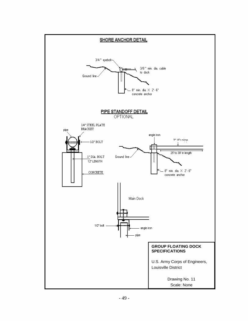
- 49 -
2” ID pipe
GROUP FLOATING DOCK SPECIFICATIONS U.S. Army Corps of Engineers, Louisville District
Drawing No. 11 Scale: None

- 50 -
14’ - 4’
20’ Maxim
Walkway
Finger Main Dock
6’
20’ 4’
KY –0123-YY
DOCK PLAN
*** EXAMPLE***
Notes: One foot of clearance is required on each side of the boat. This is to allow adequate space for maneuvering in and out of the slip. The example shown is for a typical dock. Longer main dock sections and wider fingers may be allowed in some situations. Walkway: Standard width = 4’. Maximum length = 20’, no minimum length. Main Dock: Standard width = 6’. Standard length = 14 –17’. Finger: Standard width = 4’. Length = 20’. Length of the main dock section is determined by taking the beam (widest point) of the boat, adding the width of the finger, and adding 2’ of width for the boat to maneuver in/out of the slip (i.e., beam of boat 8’ + 4’ for width of finger + 2’ maneuver in/out space = 14’ main dock section).
GROUP FLOATING DOCK SPECIFICATIONS U.S. Army Corps of Engineers, Louisville District
Drawing No. 12 Scale: None
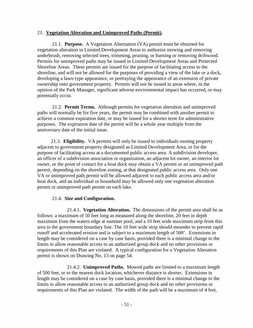
- 51 -
21. Vegetation Alteration and Unimproved Paths (Permit)
.
21.1. Purpose. A Vegetation Alternation (VA) permit must be obtained for vegetation alteration in Limited Development Areas to authorize mowing and removing underbrush, removing selected trees, trimming, pruning, or burning or removing driftwood. Permits for unimproved paths may be issued in Limited Development Areas and Protected Shoreline Areas. These permits are issued for the purpose of facilitating access to the shoreline, and will not be allowed for the purposes of providing a view of the lake or a dock, developing a lawn type appearance, or portraying the appearance of an extension of private ownership onto government property. Permits will not be issued in areas where, in the opinion of the Park Manager, significant adverse environmental impact has occurred, or may potentially occur. 21.2. Permit Terms. Although permits for vegetation alteration and unimproved paths will normally be for five years, the permit may be combined with another permit to achieve a common expiration date, or may be issued for a shorter term for administrative purposes. The expiration date of the permit will be a whole year multiple from the anniversary date of the initial issue. 21.3. Eligibility. VA permits will only be issued to individuals owning property adjacent to government property designated as Limited Development Area, or for the purpose of facilitating access at a documented public access area. A subdivision developer, an officer of a subdivision association or organization, an adjacent lot owner, an interior lot owner, or the point of contact for a boat dock may obtain a VA permit or an unimproved path permit, depending on the shoreline zoning, at that designated public access area. Only one VA or unimproved path permit will be allowed adjacent to each public access area and/or boat dock, and an individual or household may be allowed only one vegetation alteration permit or unimproved path permit on each lake.
21.4. Size and Configuration.
21.4.1. Vegetation Alteration. The dimensions of the permit area shall be as follows: a maximum of 50 feet long as measured along the shoreline, 20 feet in depth maximum from the waters edge at summer pool, and a 10 feet wide maximum strip from this area to the government boundary line. The 10 feet wide strip should meander to prevent rapid runoff and accelerated erosion and is subject to a maximum length of 500’. Extensions in length may be considered on a case by case basis, provided there is a minimal change to the limits to allow reasonable access to an authorized group dock and no other provisions or requirements of this Plan are violated. A typical configuration for a Vegetation Alteration permit is shown on Drawing No. 13 on page 54.
21.4.2. Unimproved Paths. Mowed paths are limited to a maximum length of 500 feet, or to the nearest dock location, whichever distance is shorter. Extensions in length may be considered on a case by case basis, provided there is a minimal change to the limits to allow reasonable access to an authorized group dock and no other provisions or requirements of this Plan are violated. The width of the path will be a maximum of 4 feet,

- 52 -
and configured to control rapid runoff of surface water and erosion. A typical configuration for an Unimproved Path permit is shown in Drawing No. 14 on page 55.
21.5. Grandfathered Permits for VA and Unimproved Paths. Permits that were in effect as of 31 May 1994 will be grandfathered as to size and configuration for the lifetime of the permit holder or his/her spouse. No increase in the area is allowed if the present permit exceeds new guidelines. All other conditions of this Plan apply to the permit area and any violation of those conditions may result in termination of the grandfathered permit. Upon the sale or transfer of the adjacent property, the permit shall be null and void. The new owner may apply for a permit, if eligible, in accordance with current guidelines.
21.6. Scope.
21.6.1. Tree Removal. Prior to the removal of any vegetation, the permittee shall meet with a Corps Ranger who will outline the limits of the permit area and designate certain trees or stems that must be left in the permit area. The permittee will leave a minimum of one tree for each ten feet square (100 square feet). Clear cutting will not be allowed. Trees larger than 3" diameter at ground level will not be removed unless dead, diseased, or damaged and approved for cutting.
21.6.2. Mowing. Vegetation within the permit area may be controlled by mowing with small riding mowers, push mowers or weed cutters using string cutting heads. Agricultural or industrial tractors or mowers shall not be used. Permittee shall exercise care to protect the vegetation designated to remain. Grass may not be cut less than 3” above ground.
21.6.3. Pruning and Trimming. Trees within the permit area that are larger
than 3” inches in diameter at ground level may be trimmed or pruned to a height of 7 feet above the ground or one-half the total tree height, whichever is less.
21.6.4. Removing underbrush. Permittee may selectively remove certain
undesirable vegetation within the permit area (such as poison ivy, poison oak, poison sumac, vines, briars, and thistles) in lieu of mowing.
21.6.5. Removing driftwood. Driftwood, downed timber and other floating
debris within the permit area can be removed by the authority of the VA or unimproved path permit. Disposal shall be off site or by burning as outlined in Section 21.6.7. below.
21.6.6. Herbicides. Herbicides will not be used on government property.
21.6.7. Burning. All driftwood, untreated wooden debris, treetops, etc., may
be burned unless prohibited by State or local laws and regulations. All burning shall be confined to the area on the lake bottom between minimum pool (winter pool) and seasonal pool (summer pool). All activities shall comply with burning and clean air codes, laws, rules and regulations, and permit conditions. Burning permits are issued only to individuals holding a valid vegetation alteration or unimproved path permit, but the permittee must

- 53 -
obtain a burning permit prior to any burning on project lands. The expiration date of the burning permit will coincide with that of the permitee’s vegetation alteration or unimproved path permit(s).
21.7. Marking Boundary Line. Each vegetation alteration permit or unimproved path permit holder shall mark the boundary between government lands and private property with wooden posts. Posts shall be set at the intersection of the lot boundary line with the government property line (red line) and at the mid-point between these posts. Should a government monument exist at a point where a post is required, the post may be omitted. The permittee shall not move or otherwise disturb any monument or survey marker. Posts shall be five foot long and four inches by four inches and shall be set to a depth of two feet into the ground. The permit tag provided by the Corps of Engineers shall be attached to a post as directed by the Park Manager (see Drawing No. 13 on page 54). Posts shall be installed at no cost to the Government prior to commencing any work authorized under a vegetation alteration permit or an unimproved path permit. The permittee may submit an alternate method of marking the boundary line to the Park Manager for approval, although the alternate method shall not impede inspection and surveillance of the boundary by Corps Rangers.
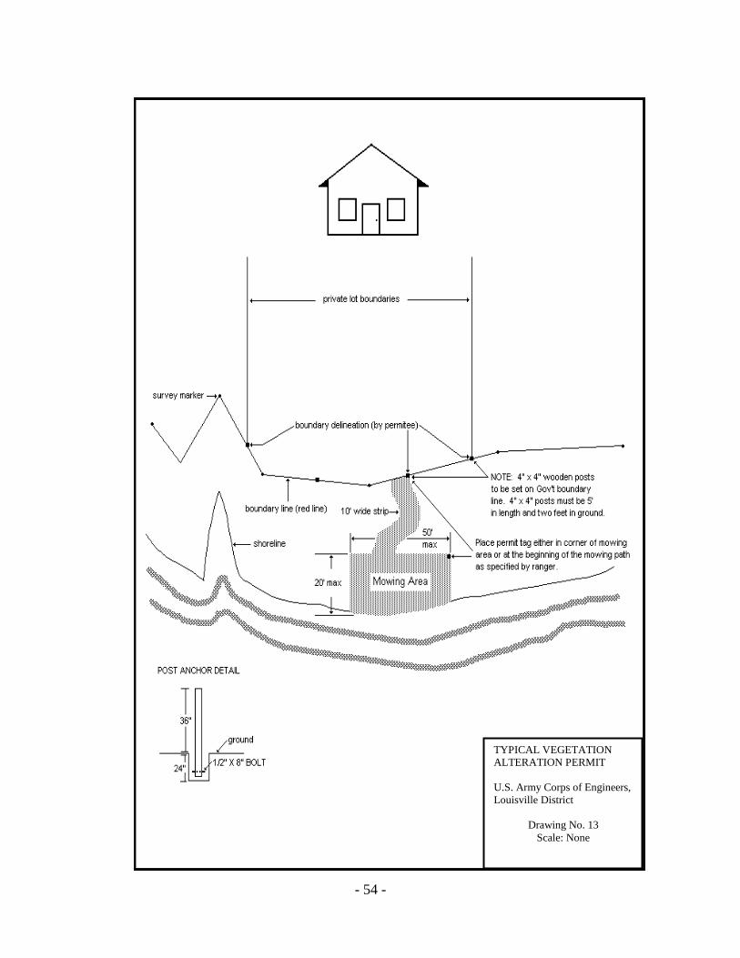
- 54 -
TYPICAL VEGETATION ALTERATION PERMIT U.S. Army Corps of Engineers, Louisville District
Drawing No. 13 Scale: None
- 55 -
4’ wide strip
TYPICAL VEGETATION ALTERATION PERMIT U.S. Army Corps of Engineers, Louisville Dist.
Drawing No. 14 Scale: None
- 56 -
22. Specified Act Permits
.
22.1. Purpose. The Park Manager may issue a one-time permit to accomplish certain activities on government property if the activity is necessary and will not cause any significant, adverse impact. Examples of this type of permit are removing and/or burning a hazardous tree(s), driftwood, dead and down trees, recovering a vehicle that inadvertently entered a protected area and cannot be removed without additional equipment, authorized planting of vegetative material on government land, etc.
22.2. Habitat Mitigation. The Park Manager may issue specified act permits for removing snags and stumps, not to exceed ten feet below summer pool to install a dock, or a permit not to exceed five feet below summer pool to open boat lanes to a dock. To mitigate the loss of habitat, the permittee may be required to construct fish attractors before removing the vegetation. The location and construction method must be approved. Permits for removing snags and stumps to open boat lanes may be issued to persons owning property on a tract of land/subdivision adjacent to government property
22.3. Habitat Enhancement and Restoration. Habitat enhancement and restoration may be allowed on government property under a vegetation alteration permit. Adjacent landowners may plant certain native vegetation on government property with prior approval. Additional information on acceptable native species and techniques may be found at the project office. 22.4. Application. A letter detailing the nature and purpose of the request should be submitted to the Park Manager. Each request will be reviewed separately and only those activities specified in the permit will be allowed in accordance with the conditions specified in the Permit. 22.5. Term. Specified Acts Permits have a specific time frame in which to perform the authorized activity. If the permittee does not complete those activities within the specified time frame, he/she must cease operations or obtain a new permit. Renewal of the permit will not be automatic, but will be at the discretion of the Park Manager. 22.6. Fee. There is no fee for this permit, however the permittee may be assessed the cost of any damages resulting from the permitted activity, or any costs incurred by the Corps of Engineers in conjunction with the permit. These permits are non-transferable. 23. Section 404 and Section 10 Permits
. Certain activities are regulated under the authority of Section 404 of the Water Pollution Control Act, Section 10, Rivers and Harbors Act of 1899 (33 USC403) or subject to the Endangered Species Act, the National Environmental Policy Act and the Fish and Wildlife Coordination Act. These activities can include dredging, the placement of riprap or fill material, construction of discharge lines, intake structures, seawalls and other fixed structures, and the discharge of dredged materials. Requests for these activities are reviewed by the Regulatory Branch of the Operations Division, and should be coordinated through the Park Manager.

- 57 -
24. Duck Blinds
. Duck blinds are regulated by the Kentucky Department of Fish and Wildlife hunting regulations.
25. Fish and Wildlife
. The government-owned lands and water, with the exception of the operations areas and public recreation areas, are licensed to the State of Kentucky Department of Fish and Wildlife for management of fish and game. Unless posted otherwise, these areas are open to the public for fishing and hunting and are subject to state regulations governing these activities. Issuing a permit or license to an individual does not preclude use of the land or waters involved by the public for hunting and fishing activities. Vegetation alteration, which impacts fish or wildlife habitat, may require mitigation by the permittee.
26. Grandfathered Facilities Unique to Rough River Lake
. The following conditions apply only to docks and related permits and licenses at Rough River Lake.
26.1. General. The national regulation that provides policy and guidance for shoreline management was revised on July 27, 1990. The revised regulation prohibits shoreline use facilities and/or activities within or near public recreation areas. Some shoreline zoning at Rough River Lake was changed from Limited Development Area to Protected Shoreline Area to comply with this requirement. This section addresses the unique situation created by this action and the disposition of the facilities which had been permitted or licensed in these areas. Permits and licenses may be issued only to adjacent property owners or property owners of a developed subdivision adjacent to government property who have legal right of access to the shoreline. The Park Manager may request documentation of the right of access.
26.2. Vegetation Alteration. Permits for vegetation alteration in effect on May 31, 1994 may be reissued to the permittee or his/her surviving spouse with no change in the size or configuration of the permit area. All other conditions of this Plan apply to the permit area and any violation of those conditions may result in termination of the grandfathered permit. New owners must comply with current regulations for Protected Shoreline Areas.
26.3. Group Boat Docks. A limited number of group dock permits were approved in areas now zoned Protected Shoreline. Permits for these docks may be reissued to the permittee, his/her surviving spouse, or to new owners. These group docks must comply with the provisions in Section 20.6. of this Plan and reference 3 (7) prior to permit renewal. These group docks must at all time meet the following conditions of P.L. 99-662:
(1) Dock is maintained in a useable and safe condition. (2) Dock does not occasion a threat to life or property (3) The holder of the permit is in substantial compliance with the existing
permit
Any group dock failing to meet these standards must be replaced in conformance with current specifications or the dock must be removed and the grandfathered permit will be terminated.

- 58 -
26.4. Access Improvements.
26.4.1. Licenses for improved paths, footbridges, stairways and steps in effect on May 31, 1994 may be reissued to the licensee, his/her surviving spouse, or to new owners. Access to group docks grandfathered by this section can be improved to adequately serve the needs of the group. Group dock members may apply for licenses for cart paths, improved paths, footbridges, stairways or steps in accordance with Section 14 of this Plan. 26.4.2. In the case where there is a prescribed limit on the length of a path or a structure (i.e., footbridge, set of stairs), extensions in length may be considered on a case by case basis, provided there is a minimal change to the limits to allow reasonable access to an authorized group dock and no other provisions or requirements of this Plan are violated.
26.5. Grandfathered Permits and Licenses. A current list of grandfathered permits and licenses is maintained at the Rough River Lake Project Office.