Embed Size (px)
DESCRIPTION
Snowdonia Paul Gannon a hillwalker’s guide to the geology & scenery Garnedd Ugain Llyn Padarn Y Llywedd Glyder Fawr Crib Goch Y Garn Llyn y Mynydd Yr Aran Carnedd y Filiast Moel Eilio Elidir Fawr Llyn Idwal Llyn y Gader Llyn Peris A 40 86 Kilometres A 40 86 A 40 86 A 4 2 4 4 A 4 0 8 5 A 5 999m 947m 898m 821m 923m 726m 1085m 747m Paul Gannon www.pesdapress.com
Citation preview
SnowdoniaPaul Gannon
a hillwalker’s guide to the geology & scenery
Snowdonia
Llyn Cwellyn
Llyn Padarn
Llyn Peris
MarchlynMawr
MarchlynBach
Llyn y Mynydd
Llyn Ogwen
Llyn Idwal
Llyn Eigiau
Llyn Cowlyd
FfynnonLlugwy
LlynauMymbyr
LlynauDiwaunedd
Llyn Gwynant
Llyn Llydau
Glaslyn
Llyn Cwmffynnon
Llyn yGader
Llyn Dwythwch
Elidir Fawr
Snowdon
Moel Siabod
Tryfan
Glyder Fawr
Glyder Fach
Y Garn
CarneddLlewelyn
Carnedd Dafydd
FfynnonLloer
Capel Curig
Llanberis
Rhyd-Ddu
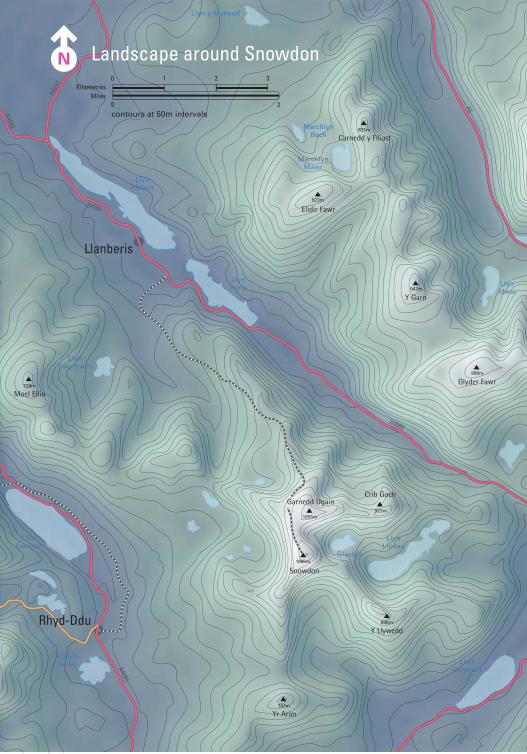
Landscape around Snowdon
A4086
A498
A4086
A4086
A4086
A424
4
A4085
A5
A5
999m
805m
947m
1085m
898m
923m1055m
Crib Goch
Y Llywedd
Garnedd Ugain
994m
872m
1044m
1064m
923m
contours at 50m intervals
Yr Aran747m
Carnedd y Cribau591m
Moel Eilio726m
Carnedd y Filiast821m
Kilometres1 2 30
Miles0 2
www.pesdapress.com
SnowdoniaPaul Gannon

First published in Great Britain 2008 by Pesda Press
Unit 22, Galeri
Doc Victoria
Caernarfon
Gwynedd
LL55 1SQ
© Copyright 2008 Paul Gannon
ISBN: 978-1-906095-04-8
The Author assert the moral right to be identified as the authors of this work.
All rights reserved. No part of this publication may be reproduced, stored in a retrieval
system, or transmitted, in any form or by any means, electronic, mechanical, photocopy-
ing, recording or otherwise, without the prior written permission of the Publisher.
Printed in Poland, produced by Polska Book.
Cover Photo: Tryfan from Y Garn,
Pierino Algieri (www.algieri-images.co.uk)

To Tim and Clair
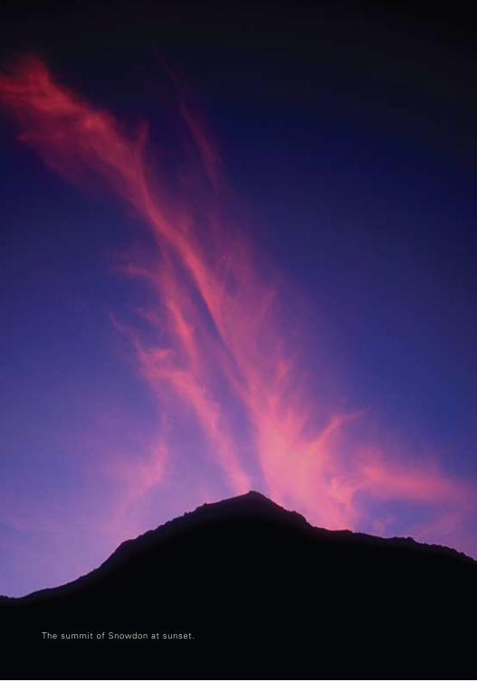
The summit of Snowdon at sunset.
Contents
Foreword . . . . . . . . . . . . . . . . . . . . . . . . . . . . . . . . . . . . . . . . . . . . 7
Introduction . . . . . . . . . . . . . . . . . . . . . . . . . . . . . . . . . . . . . . . . 8
Chapter 1 A view over 700 Million Years of Snowdonia . . . 11
Chapter 2 Crashing Plates and Mighty Volcanoes . . . . . . . . . . 27
Chapter 3 The Pitts Head Tuffs . . . . . . . . . . . . . . . . . . . . . . . . . . . . . . . 31
Chapter 4 The Snowdon Caldera Collapse . . . . . . . . . . . . . . . . . . . 37
Chapter 5 Mountains of Ash and Slate . . . . . . . . . . . . . . . . . . . . . . 53
Chapter 6 Snowdon’s Ice Age . . . . . . . . . . . . . . . . . . . . . . . . . . . . . . . . . 61
Chapter 7 The Glyderau and Glaciation . . . . . . . . . . . . . . . . . . . . . 79
Chapter 8 The Rural Landscape . . . . . . . . . . . . . . . . . . . . . . . . . . . . . . . 89
Chapter 9 The Industrial Landscape . . . . . . . . . . . . . . . . . . . . . . . . . . 99
CoNTeNTS
About the Walks . . . . . . . . . . . . . . . . . . . . . . . . . . . . . . . . . . . . . . 109
Walk #1 Snowdon . . . . . . . . . . . . . . . . . . . . . . . . . . . . . . . . . . . . . . . . . . . . . . . 115
Walk #2 Glyder Fawr & Twll Du . . . . . . . . . . . . . . . . . . . . . . . . . . . . . . . 127
Walk #3 Glyder Fach . . . . . . . . . . . . . . . . . . . . . . . . . . . . . . . . . . . . . . . . . . . . 137
Walk #4 Tryfan . . . . . . . . . . . . . . . . . . . . . . . . . . . . . . . . . . . . . . . . . . . . . . . . . . 147
Walk #5 Y Carneddau . . . . . . . . . . . . . . . . . . . . . . . . . . . . . . . . . . . . . . . . . . . 155
Walk #6 Elidir Fawr . . . . . . . . . . . . . . . . . . . . . . . . . . . . . . . . . . . . . . . . . . . . . 161
Walk #7 Carnedd y Cribau . . . . . . . . . . . . . . . . . . . . . . . . . . . . . . . . . . . . . . 171
Walk #8 Northern Glyderau Cwms . . . . . . . . . . . . . . . . . . . . . . . . . . . . 181
Walk #9 Nant Gwynant . . . . . . . . . . . . . . . . . . . . . . . . . . . . . . . . . . . . . . . . . 187
Walk #10 Llyn Padarn . . . . . . . . . . . . . . . . . . . . . . . . . . . . . . . . . . . . . . . . . . . . 195
Walk #11 Llanberis Pass . . . . . . . . . . . . . . . . . . . . . . . . . . . . . . . . . . . . . . . . . . 207
Walk #12 Cwm Dwythwch . . . . . . . . . . . . . . . . . . . . . . . . . . . . . . . . . . . . . . . 217
Walk #13 Vivian and Dinorwig Quarries . . . . . . . . . . . . . . . . . . . . . . . 225
Acknowledgements & Sources . . . . . . . . . . . . . . . . . . . . . . . . . . . . . . . . . . . . . . . 231
Glossary of Geological & Geomorphological Terms . . . . . . . . . . . . . . . 233
Welsh Words . . . . . . . . . . . . . . . . . . . . . . . . . . . . . . . . . . . . . . . . . . . . . . . . . . . . . . . . . . 237
Index of Place Names . . . . . . . . . . . . . . . . . . . . . . . . . . . . . . . . . . . . . . . . . . . . . . . . . 239
7
Foreword
The mountains represent a living museum of geological history of unfathomable timescale.
Their archives hint at a grand story, revealed in detail in the small print, which explains some-
thing of this spiralling rock we call earth.
My understanding of geology is sketchy in the extreme, but it’s now reckoned that the
earth itself is about 4,500 million years old. The rocks of northern Snowdonia were laid down,
apparently, over 400 million years ago, so the Earth was already old when Snowdonia ap-
peared. This story told in this book reaches back from the present day, to the Cambrian era
which predates the rocks of Snowdon.
I wonder if, like me, you find it difficult to comprehend vast spans of time such as these?
A number of years ago I took myself off into the seclusion of Torridon to contemplate the
question of time and space. I found it easy enough to consider events of a hundred years, or
even five hundred, but was lost trying to contemplate the ages of our mountains.
I remember stopping on a rocky platform on a hill called Baosbheinn and looking over
and beyond the lonely waters of Loch na h-Oidhche. It was then that I realised for the first
time that nearby Beinn an Eoin and neighbouring Beinn Dearg were made up of layer upon
layer of rock, which were replicas of the strata that I was now climbing on Baosbheinn. I could
see clearly, as my eye moved downhill, that the rocks were becoming older, from the relatively
young sandstone peaks (now toothless, but once graced by quartzite caps), down through the
aeons to darker, older slopes and the bedrock of ancient gneiss. Created over millions of years,
over millions of years they were being worn down.
It is easy to consider mountains as timeless, but here was evidence of the steady progress
of time. I may have lacked great insight into the changes brought about over two hundred
and fifty million years, but I felt more at ease with the concept. I went home more aware of
my own impermanence amid these hoary giants that dominate our landscape.
The only way to get to grips with the legacy of our mountains, is walk amongst the
ancient rocks, to climb them, to touch them and to feel their texture and their grain. This book
will guide you to the signs which tell the most ancient story of all.
Cameron McNeish
8
This book is intended to help those who love Snowdonia’s mountain scenery to under-
stand how this haunting landscape came about. I have divided the book into two parts. The
first narrates the story of colliding continents, volcanoes, mountain-building and glaciation in
creating Snowdonia, explaining why volcanoes occurred, what rocks they created and how to
Introduction
The spectacular mountain scenery of Snowdonia, with its arrays of steep rocky hills, atmos-
pheric deep valleys and sparkling lakes, is one of the scenic highlights of the British Isles. The
rugged beauty of the landscape attracts millions of visitors to North Wales every year. And of
them, as many as half a million slog up to the summit of Snowdon – Yr Wyddfa in Welsh – on
one or other of half-a-dozen popular walking routes. The walkers are there joined by another
200,000 or so who take a more leisurely journey to the top, thanks to the Snowdon Mountain
Railway. Many thousands more stay in the valley, and come just to soak up the stunning
landscape that stretches before them.
Photo 0.1 View towards Snowdon from Capel Curig.
9
I hope the reader will come to appreciate the interplay of volcanoes, glaciation, erosion
and other influences on the landscape. The aim is to enable the reader to identify major and
minor landscape features in Snowdonia and maybe elsewhere too. The landscape we see be-
fore us is the product of many different forces and factors. Identifying and unravelling these
forces and factors on the ground is an endlessly fascinating pastime for the landscape lover.
I have concentrated on what you can see as you walk around the hills without the need to
use a hand lens or other geological tool, pointing instead to conspicuous, easily seen features
in rocks and the overall shape of the terrain in accounting for the present day landscape.
While geology is a fascinating subject, it is also a science, and relies on a complex scien-
tific terminology. My aim has been to minimise the use of jargon and to make the processes
that have determined the shape of the landscape comprehensible to the average reader. This
has meant some simplification of the jargon and a pruning of the detail. All the same, we
INTroDUCTIoN
interpret signs of mountain-building and glaciation on the ground. The second half describes
several recommended walks, of differing levels of difficulty, but all with a wide variety of
geological features to be seen and, most important, enjoying consistently fantastic views of
the very best of Snowdonia’s wonderful scenery.
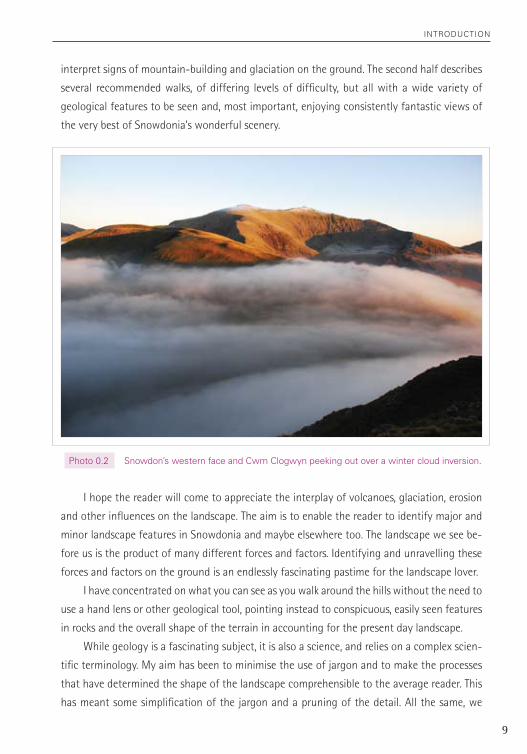
Photo 0.2 Snowdon’s western face and Cwm Clogwyn peeking out over a winter cloud inversion.
10
INTroDUCTIoN
will, I’m afraid, have to deal with a minimal set of terms such as ‘plate tectonics’ and ‘fissure-
vents’, ‘magma’ and ‘intrusive’ rocks, ‘ice sheets’ and ‘moraines’, and the like.
When I first use a piece of jargon I have put it in quote marks (for example, ‘continental
plate’). Many of these terms are defined in the Glossary, but I have also sometimes assumed
that the meaning of a term is obvious from the context in which it appears. Occasionally I
have used quote marks to identify a bit of everyday idiom, such as a ‘blob’ of magma.
The reader may well find it useful, while reading the book, to have open and to hand
a copy of the OS 1:25,000 map (OL17) or a larger scale map of Snowdon (such as the OS
1:50,000 or the Harvey 1:40,000). This will assist in locating places mentioned as examples
in the text (with help of the list, at the back of the book, of grid references of all local places
named in the text). A map will also help to convey an idea of the present-day physical shape
of a location or feature and its surrounds when it is discussed.
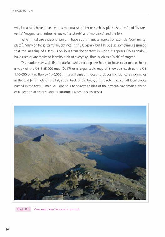
Photo 0.3 View east from Snowdon’s summit.
61
Chapter 6
Snowdon’s Ice Age
The period between the end of the Caledonian mountain-building episode, about 400 million
years ago, and the start of the Ice Ages, in much more recent times, has left little record in
central Snowdonia of what happened during those intervening aeons.
For some of that time central Snowdonia was above sea level. During those periods a lot
of material would have been eroded away, millimetre by millimetre, year by year, for millions
of years, reducing the Alpine or Himalayan-sized mountains of the Caledonides range to
a few hardened stumps, the mountains we see today. There were further tectonic events
elsewhere on the earth which affected Snowdonia, such as the collision of Africa and Europe,
but with much less far-reaching consequences.
We can assume that central Snowdonia was also almost certainly under sea level at
other times. During these periods new sedimentary rocks would have been laid down.
However, if this did happen, there is no evidence to show it that it did and any rocks that
were laid down have been entirely eroded away. For example, many geologists believe that
the whole of Britain must have been below sea level during the era known as the ‘Cretaceous’
(from 145 million until 60 million years ago). This was the period during which the chalk for-
mations were laid down and which today crop out in much of southern and eastern Britain.
The present theory assumes that chalk was laid down over the whole of Britain and that it
has been entirely eroded away from all those areas where older rocks are exposed, including
central Snowdonia.
And so we will pass over 350 million years in fewer than 300 words, moving at break-
neck speed to the near present and a timescale measured in thousands, rather than millions,
of years.
There have been twenty different cold or ‘ice’ ages on the earth since 1,600,000 years
ago, interspersed with temperate ‘inter-glacial’ phases. Plant remains from the temperate
period between 100,000 years and 80,000 years ago have been uncovered in North Wales
under the glacial deposits (known nowadays as ‘till’, though previously called ‘boulder clay’)
of later ice ages. But, in general, each resurgent ice age wipes away the evidence of the
effects of its predecessor on the landscape.
chapter 6 – Snowdon'S Ice age
62
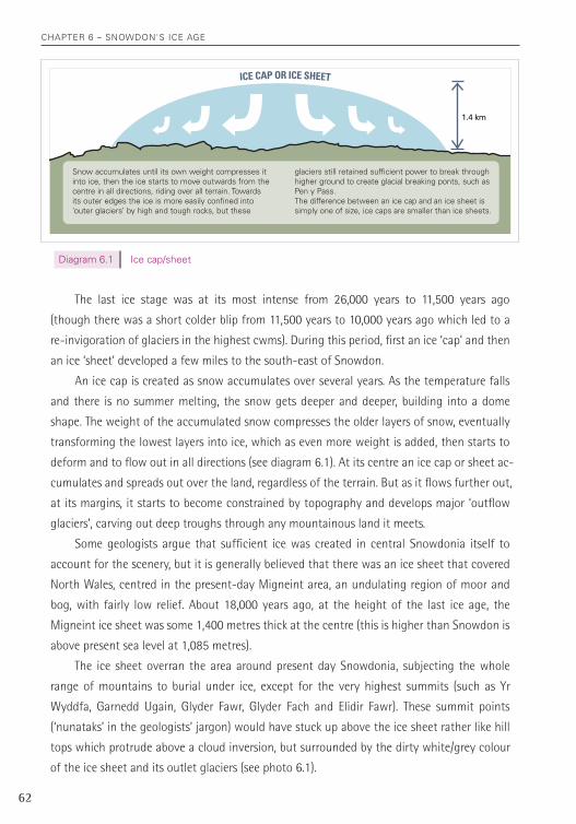
diagram 6.1 Ice cap/sheet
The last ice stage was at its most intense from 26,000 years to 11,500 years ago
(though there was a short colder blip from 11,500 years to 10,000 years ago which led to a
re-invigoration of glaciers in the highest cwms). During this period, first an ice ‘cap’ and then
an ice ‘sheet’ developed a few miles to the south-east of Snowdon.
An ice cap is created as snow accumulates over several years. As the temperature falls
and there is no summer melting, the snow gets deeper and deeper, building into a dome
shape. The weight of the accumulated snow compresses the older layers of snow, eventually
transforming the lowest layers into ice, which as even more weight is added, then starts to
deform and to flow out in all directions (see diagram 6.1). At its centre an ice cap or sheet ac-
cumulates and spreads out over the land, regardless of the terrain. But as it flows further out,
at its margins, it starts to become constrained by topography and develops major ‘outflow
glaciers’, carving out deep troughs through any mountainous land it meets.
Some geologists argue that sufficient ice was created in central Snowdonia itself to
account for the scenery, but it is generally believed that there was an ice sheet that covered
North Wales, centred in the present-day Migneint area, an undulating region of moor and
bog, with fairly low relief. About 18,000 years ago, at the height of the last ice age, the
Migneint ice sheet was some 1,400 metres thick at the centre (this is higher than Snowdon is
above present sea level at 1,085 metres).
The ice sheet overran the area around present day Snowdonia, subjecting the whole
range of mountains to burial under ice, except for the very highest summits (such as Yr
Wyddfa, Garnedd Ugain, Glyder Fawr, Glyder Fach and Elidir Fawr). These summit points
(‘nunataks’ in the geologists’ jargon) would have stuck up above the ice sheet rather like hill
tops which protrude above a cloud inversion, but surrounded by the dirty white/grey colour
of the ice sheet and its outlet glaciers (see photo 6.1).
Snow accumulates until its own weight compresses it into ice, then the ice starts to move outwards from the centre in all directions, riding over all terrain. Towards its outer edges the ice is more easily confined into ‘outer glaciers’ by high and tough rocks, but these
glaciers still retained sufficient power to break through higher ground to create glacial breaking ponts, such as Pen y Pass.The difference between an ice cap and an ice sheet is simply one of size, ice caps are smaller than ice sheets.
1.4 km
ICE CAP OR ICE SHEET
chapter 6 – Snowdon'S Ice age
63
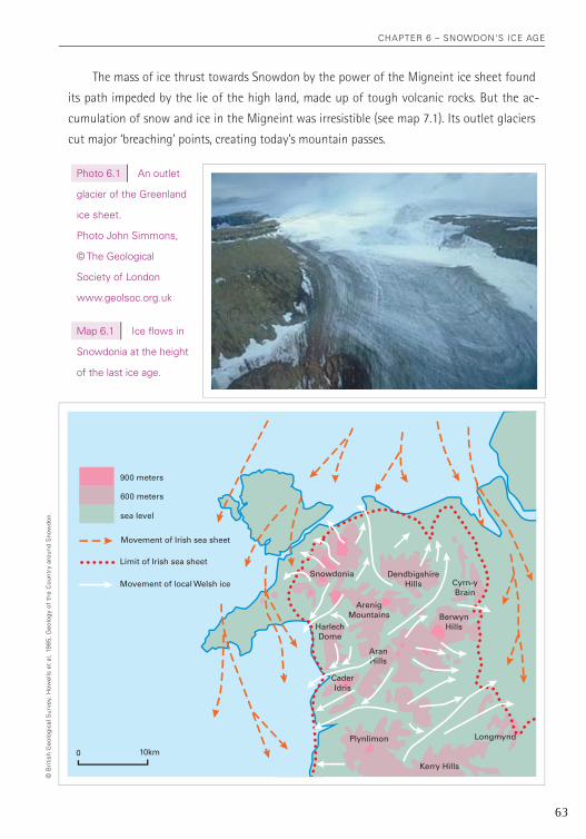
photo 6.1 an outlet
glacier of the greenland
ice sheet.
photo John Simmons,
© the geological
Society of London
www.geolsoc.org.uk
Map 6.1 Ice flows in
Snowdonia at the height
of the last ice age.
DendbigshireHills
SnowdoniaCyrn-yBrain
ArenigMountains
AranHills
CaderIdris
HarlechDome
BerwynHills
Plynlimon
Kerry Hills
Longmynd
sea level
600 meters
900 meters
Movement of Irish sea sheet
Limit of Irish sea sheet
Movement of local Welsh ice
10km0
The mass of ice thrust towards Snowdon by the power of the Migneint ice sheet found
its path impeded by the lie of the high land, made up of tough volcanic rocks. But the ac-
cumulation of snow and ice in the Migneint was irresistible (see map 7.1). Its outlet glaciers
cut major ‘breaching’ points, creating today’s mountain passes.
© B
riti
sh g
eolo
gica
l Sur
vey.
how
ells
et
al,
1985
, g
eolo
gy o
f th
e c
ount
ry a
roun
d S
now
don.
chapter 6 – Snowdon'S Ice age
64
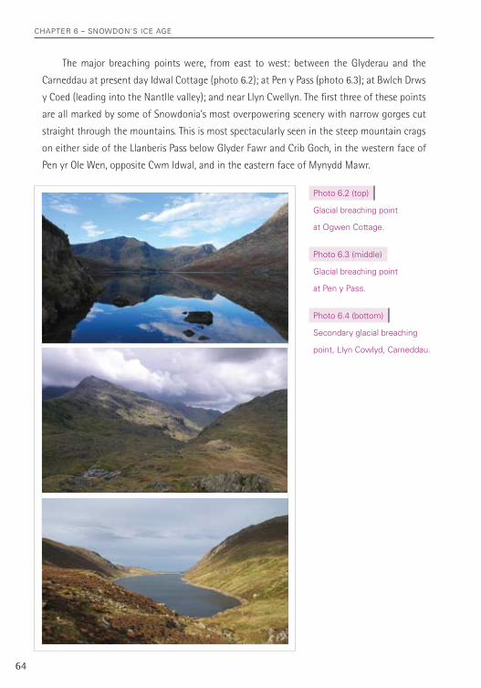
The major breaching points were, from east to west: between the Glyderau and the
Carneddau at present day Idwal Cottage (photo 6.2); at Pen y Pass (photo 6.3); at Bwlch Drws
y Coed (leading into the Nantlle valley); and near Llyn Cwellyn. The first three of these points
are all marked by some of Snowdonia’s most overpowering scenery with narrow gorges cut
straight through the mountains. This is most spectacularly seen in the steep mountain crags
on either side of the Llanberis Pass below Glyder Fawr and Crib Goch, in the western face of
Pen yr Ole Wen, opposite Cwm Idwal, and in the eastern face of Mynydd Mawr.
photo 6.2 (top)
glacial breaching point
at ogwen cottage.
photo 6.3 (middle)
glacial breaching point
at pen y pass.
photo 6.4 (bottom)
Secondary glacial breaching
point, Llyn cowlyd, carneddau.
chapter 6 – Snowdon'S Ice age
65
There were secondary breaching points too – on the Snowdon massif these were Bwlch y
Saethau, Bwlch Cwm Llan, Bwlch Brwynog and Bwlch Maesgwm, and on the Glyderau at Twll
Du (the Devil’s Kitchen above Cwm Idwal), Cwm y Caseg Fraith and Bwlch Goleuni. Bwlch y
Brecan, on the Glyderau Ridge below Foel Goch, was also a secondary breaching point, but here
the ice flowed from the Nant Ffrancon side into Cwm Dudodyn and the lower Llanberis Pass.
On the Carneddau there was a secondary breaching point between Pen Llithrig y Wrach and
Creigiau Gleision (above Llyn Cowlyd Reservoir – photo 6.4), as is obvious today from the profile
of the lower Carneddau as seen from Tryfan or the southern end of the Glyderau Ridge.
At these secondary breaching points, the ice found a way over the obstruction of the
hard volcanic rock, but without cutting deep trench-like valleys. Instead it just left the cols
that separate the present day summits of the Snowdon massif and the Glyderau. Each col or
bwlch provides present day walkers, as they have to descend and re-ascend between summits,
with excellent opportunities for pondering the fact that water, in the form of ice, is more
powerful than rock (though the ice is dependent on cracks in the rocks and other weaknesses
to start the process of breaking the rock up). These slopes also often provide an opportunity
to study the changing beds of rocks – for example the climb from Bwlch y Brecan to the
summit of Y Garn crosses a succession of rock types, several volcanic and some sedimentary,
illustrating the way in which the area’s unique geological history has ended up providing us
with so many great walks, walks that cross over millions of years of rock of many different
types and is now exposed by glaciation.
The landscape of Snowdonia is finally getting close to its present form. But the declining
years of the last ice age were of vital importance in adding some key stages in the etching of
the modern shape of central Snowdonia.
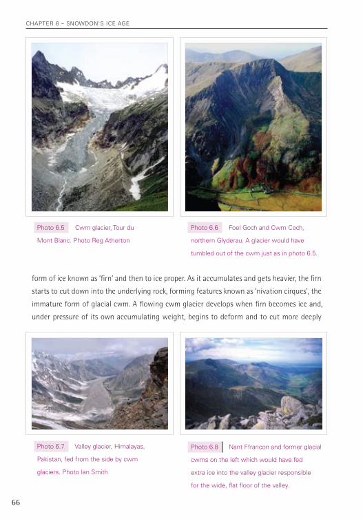
From about 18,000 years ago temperatures started to rise again and from then until
about 12,000 years ago, ‘cwm glaciers’ poured out of hollows high in the mountains (see
photos 6.5 and 6.6). The ice that flowed out of these glacial ‘cwms’ (or ‘corries’ or ‘cirques’)
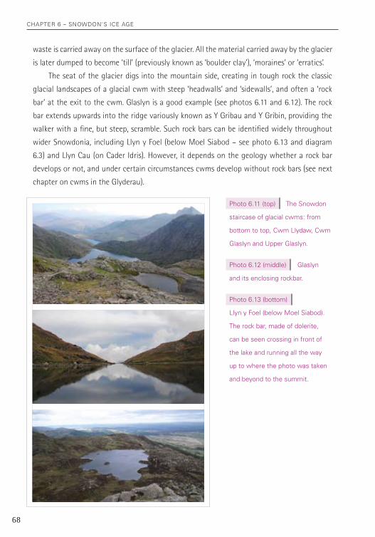
fed larger ‘valley glaciers’ in the trenches cut by the outlet glaciers (see photos 6.7, 6.8, 6.9
and 6.10). These cwm glaciers became the key agents of glacial sculpting of the present-
day landscape, deepening the work of earlier glacial periods. This period of just 6,000 years
was to see some of the most intense glaciation in the area and to leave many of the most
magnificent aspects of today’s scenery. The scenery at the time was no doubt reminiscent of
the Alps and other ranges today (except in scale of mountains), with year round snow and
steep glaciers, often marked by ice falls (the glacier’s equivalent of a waterfall).
As with the ice cap, glaciers form when the accumulation of snow, in a hollow or gully
on a mountain-side, exceeds the rate of snow loss (or ‘ablation’), and it is turned first to a
chapter 6 – Snowdon'S Ice age
66
photo 6.5 cwm glacier, tour du
Mont Blanc. photo reg atherton
photo 6.6 Foel goch and cwm coch,
northern glyderau. a glacier would have
tumbled out of the cwm just as in photo 6.5.
photo 6.7 Valley glacier, himalayas,
pakistan, fed from the side by cwm
glaciers. photo Ian Smith
photo 6.8 nant Ffrancon and former glacial
cwms on the left which would have fed
extra ice into the valley glacier responsible
for the wide, flat floor of the valley.
form of ice known as ‘firn’ and then to ice proper. As it accumulates and gets heavier, the firn
starts to cut down into the underlying rock, forming features known as ‘nivation cirques’, the
immature form of glacial cwm. A flowing cwm glacier develops when firn becomes ice and,
under pressure of its own accumulating weight, begins to deform and to cut more deeply
chapter 6 – Snowdon'S Ice age
67
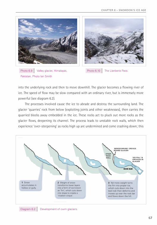
into the underlying rock and then to move downhill. The glacier becomes a flowing river of
ice. The speed of flow may be slow compared with an ordinary river, but is immensely more
powerful (see diagram 6.2).
The processes involved cause the ice to abrade and destroy the surrounding land. The
glacier ‘quarries’ rock from below (exploiting joints and other weaknesses), then carries the
quarried blocks away embedded in the ice. These rocks act to pluck out more rocks as the
glacier flows, deepening its channel. The process leads to unstable rock walls, which then
experience ‘over-steepening’ as rocks high up are undermined and come crashing down; this
photo 6.9 Valley glacier, himalayas,
pakistan. photo Ian Smith
photo 6.10 the Llanberis pass.
STEEP BACK WALL
ROCK BAR
‘BERGSCHRUND’ CREVICE BEHIND GLACIER
‘ICE-FALL’ & CREVICES IN GLACIER
2 Weight of snow transforms lower layers into a form of ice known as ‘firn’, which cuts down into slope to create a ‘nivation cirque’.
ROCK BAR
3 Yet more weight turns the firn into proper ice, which cuts down into the bed rock then deforms and moves up over the rock bar and flows down the hill.
1 Snow accumulates in hollow or gully.
diagram 6.2 development of cwm glaciers.
chapter 6 – Snowdon'S Ice age
68
waste is carried away on the surface of the glacier. All the material carried away by the glacier
is later dumped to become ‘till’ (previously known as ‘boulder clay’), ‘moraines’ or ‘erratics’.
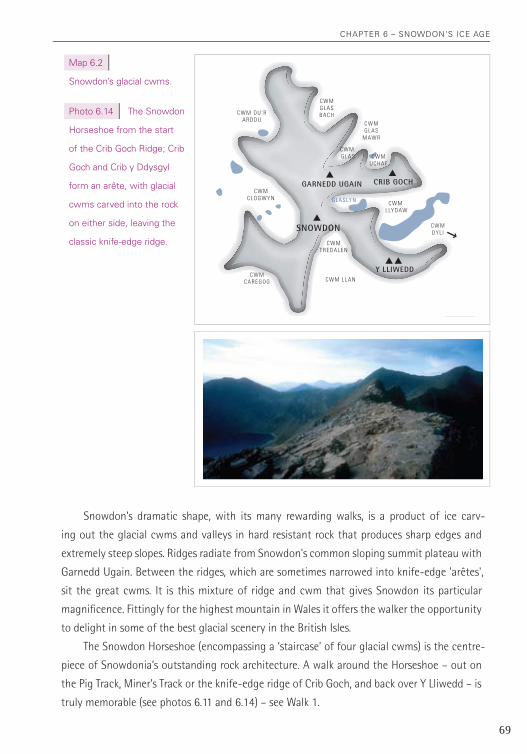
The seat of the glacier digs into the mountain side, creating in tough rock the classic
glacial landscapes of a glacial cwm with steep ‘headwalls’ and ‘sidewalls’, and often a ‘rock
bar’ at the exit to the cwm. Glaslyn is a good example (see photos 6.11 and 6.12). The rock
bar extends upwards into the ridge variously known as Y Gribau and Y Gribin, providing the
walker with a fine, but steep, scramble. Such rock bars can be identified widely throughout
wider Snowdonia, including Llyn y Foel (below Moel Siabod – see photo 6.13 and diagram
6.3) and Llyn Cau (on Cader Idris). However, it depends on the geology whether a rock bar
develops or not, and under certain circumstances cwms develop without rock bars (see next
chapter on cwms in the Glyderau).
photo 6.11 (top) the Snowdon
staircase of glacial cwms: from
bottom to top, cwm Llydaw, cwm
glaslyn and Upper glaslyn.
photo 6.12 (middle) glaslyn
and its enclosing rockbar.
photo 6.13 (bottom)
Llyn y Foel (below Moel Siabod).
the rock bar, made of dolerite,
can be seen crossing in front of
the lake and running all the way
up to where the photo was taken
and beyond to the summit.
chapter 6 – Snowdon'S Ice age
69
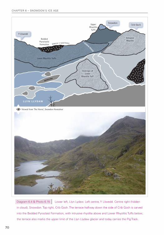
Snowdon’s dramatic shape, with its many rewarding walks, is a product of ice carv-
ing out the glacial cwms and valleys in hard resistant rock that produces sharp edges and
extremely steep slopes. Ridges radiate from Snowdon's common sloping summit plateau with
Garnedd Ugain. Between the ridges, which are sometimes narrowed into knife-edge 'arêtes',
sit the great cwms. It is this mixture of ridge and cwm that gives Snowdon its particular
magnificence. Fittingly for the highest mountain in Wales it offers the walker the opportunity
to delight in some of the best glacial scenery in the British Isles.
The Snowdon Horseshoe (encompassing a ‘staircase’ of four glacial cwms) is the centre-
piece of Snowdonia’s outstanding rock architecture. A walk around the Horseshoe – out on
the Pig Track, Miner’s Track or the knife-edge ridge of Crib Goch, and back over Y Lliwedd – is
truly memorable (see photos 6.11 and 6.14) – see Walk 1.
Map 6.2
Snowdon’s glacial cwms.
photo 6.14 the Snowdon
horseshoe from the start
of the crib goch ridge; crib
goch and crib y ddysgyl
form an arête, with glacial
cwms carved into the rock
on either side, leaving the
classic knife-edge ridge.SNOWDON
Y LLIWEDD
GARNEDD UGAIN CRIB GOCH
C W M L LY D AW
G L A S LY N
C W MG L A S
M AW R
C W MU C H A F
C W MG L A SB A C HC W M D U ’ R
A R D D U
C W MC L O G W Y N
C W MC A R E G O G C W M L L A N
C W MT R E D A L E N
C W M G L A S
C W MD Y L I
chapter 6 – Snowdon'S Ice age
70
L LY N L LY D AW
Bedded PyroclasticFormation BWICH Y SAETHAU
UpperRhyolitic
Tuffs
Intrusive Rhyolite
Outcrops of Lower
Rhyolitic Tuff
Lower Rhyolitic Tuffs
MORAINE
Y GRIBIN RIDGE
Viewed from ‘The Horns’, Snowdon Horseshoe
SnowdonCrib Goch
Y Lliwedd
diagram 6.4 & photo 6.15 Lower left, Llyn Lydaw. Left centre, Y Lliwedd. centre right (hidden
in cloud), Snowdon. top right, crib goch. the terrace halfway down the side of crib goch is carved
into the Bedded pyroclast Formation, with intrusive rhyolite above and Lower rhyolitic tuffs below;
the terrace also marks the upper limit of the Llyn Llydaw glacier and today carries the pig track.
chapter 6 – Snowdon'S Ice age
71
All the standard routes up Snowdon provide both a bird's eye overview, looking down
into the glacial cwms from the higher reaches. The lower parts of the routes also bring the
walker closer to the detail of glaciation – ‘moraines’ (mounds of rock, now usually covered
with vegetation, left, for example, by ‘retreating glaciers’), ‘roches moutonées’ (rock outcrops
smooth on one side and craggy on the other) and 'rock steps’ (differences in height in a valley
where two glaciers joined and deepened the valley floor in a sharp step). A walk lower down
also brings a different perspective on the rock formations. Both high and low parts of the
walks provide a chance to assess the scale of work done by the cwm glaciers of the last few
thousand years of the ice age. To gaze upwards is as important as casting an eye downwards
in gaining a feel for the power of ice. The depth of the cwms is perhaps best appreciated from
the Miners’ Track between Llyn Llydaw and Glaslyn.
Lowest and widest of the staircase of cwms is Cwm Dyli, with Llyn Teryn cupped away
in a corner (best seen from the Miners’ Track), and unfortunately scarred by a modern intru-
sion – a highly conspicuous pipeline feeding a hydraulic power station in Nant Gwynant (see
photo 10.13). Lines of moraines run east-west across the Cwm Dyli marking stages in the
‘retreat’ of the glacier as rising temperatures moved in phases regularly shifting the melting
point closer back to the source. An andesitic intrusion forms the jagged rock step at the back
of Cwm Dyli, from near Llyn Teryn (see photo 6.5). The ice has plucked the rock away from the
front of the andesite leaving nearly vertical walls. These andesite crags are easily seen on the
recommended walk on Snowdon on the Miners’ Track (Walk 1) where they display some very
clear ‘columnar jointing’ (see photo w1.1). The crags could be described as very large ‘roche
moutonées’, that common feature of glacial areas, where a smooth rounded shape faces
‘upstream’ and a craggy, plucked one ‘downstream’.
The broad base of Cwm Dyli was scooped out by the glaciers pouring out of Cwm Llydaw
immediately above it and further up comes Cwm Glaslyn, both containing glacial lakes. Cwm
lakes can be quite deep. Glaslyn is 40 metres deep and Llyn Llydaw, 57 metres at its deepest
point. The Pig Track runs on a shelf high above Cwm Llydaw, where softer ‘Bedded Pyroclastic
Formation’ rocks are sandwiched between the tougher Lower Rhyolitic Tuffs (below) and
intrusive rhyolite (above). This shelf also marks the rough height of glacier in Cwm Llydaw,
which not only poured out through Cwm Dyli, but also breached the ridge at Bwlch y Moch,
below Crib Goch’s eastern ridge, to pour down northwards into the Llanberis Pass (see photo
6.15 and diagram 6.4).
Eventually the temperature started to rise again, until only the highest points could
sustain the cold conditions needed to support a glacier. It was in this late stage that Upper
Glaslyn came into being (see photo 6.11). It is often missed by walkers hauling up the last

chapter 6 – Snowdon'S Ice age
72
stages of the Pig Track, but is well worth a short detour to peer over a retaining wall (erected
as part of the mining operations here, so very great care needs to be taken moving into and
out of the area). From the threshold of the tiny cwm, peering down at Glaslyn below and Llyn
Llydaw below that, it is easy to get a feel of the retreating staircase of glaciers of the recent
past. Here was the seat of the last remnants of glaciation in the Snowdon Horseshoe.
Undoubtedly among of the scenic masterpieces of the Snowdon Horseshoe are the
‘arêtes’ of Crib Goch and Crib y Ddsgyl on the northern side. The somewhat less sharp-edged
ridge of Y Lliwedd on the southern side is no less magnificent a viewpoint – and for the
landscape gazer probably provides a less distracting point on which to sit and wonder at the
mixture of rock and water laid out before you (see photo 6.16). Crib Goch and Crib y Ddsygl
got their shape as glaciers, on one side in the Horseshoe and on the other side in Cwm Uchaf
and Cwm Glas, all cut back into the head and side of their cwms, leaving the sharp ridge and
its exhilarating walk (see photo 6.14).
Snowdon’s other great cwms, Cwm Glas Mawr, Cwm Glas Bach, Cwm du’r Arddu, Cwm
Clogwyn, Cwm Caregog, Cwm Llan and Cwm Merch should not be overlooked and all are
worth exploring if you have the time and experience to veer off the tracks and navigate your
own route (except Cwm Llan which is on Watkin Path), especially on days when the clouds
cover the summits.
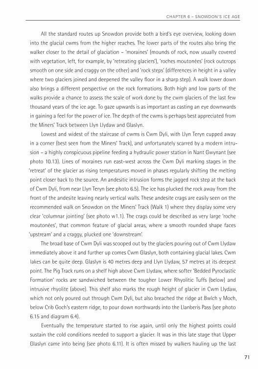
From the Llanberis Pass, or from above it on the flanks of Glyder Fawr, the route up
through Cwm Glas Mawr to Cwm Uchaf (‘upper cwm’) and Cwm Glas looks impossible for
anyone other than climbers (see photo 6.17). But despite appearances there are some routes
for those prepared to scramble up steep slopes – though be warned that going into the higher
photo 6.16
Y Lliwedd, a
glacial arête.
chapter 6 – Snowdon'S Ice age
73
reaches is a serious undertaking and should be done only in clear weather. There are only a
few safe routes out and these are hard to find, and as there are dangerously steep crags above
and below on all sides a minor navigational error could be catastrophic.
Standing near the cliff edge of high up in Cwm Glas, looking down into Cwm Glas Mawr
immediately below and to the Llanberis Pass beyond, you can imagine the ice tumbling out of
the inner cwm, cracked open in a mass of crevices, just like an ice fall seen in the Alps. Just as
Upper Glaslyn was the seat of the final glacier to develop on Snowdon, so the glaciers of Cwm
Uchaf and Cwm Glas came into existence at a late stage, when conditions were no longer
sufficiently cold to sustain the seat of a glacier lower down in Cwm Glas Mawr. Here, and in
the Snowdon Horseshoe, and especially in winter, the ice age is almost palpable. It becomes
easy to appreciate the concept that we may well be in a temporary warm period between
spells of widespread ice.
Around Crib Goch and Cwm Glas Mawr we are walking above the fissure-vents where the
biggest eruptive episode of the LRT took place, the eruptions that led to the collapse of the
Snowdon caldera. Here too is the most dramatic evidence of glaciation. Other areas also under-
went mountain building pressures and ice ages, but in other places softer rocks have produced
softer landscapes. It is Snowdon’s tough volcanic tuffs and intrusive rocks, and the resistance
they put up to glacial carving, that makes its scenery so stark, so demanding of attention.
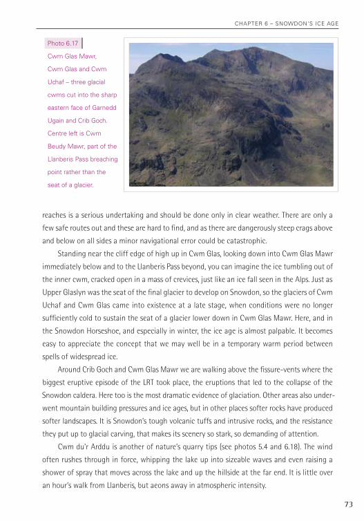
Cwm du’r Arddu is another of nature’s quarry tips (see photos 5.4 and 6.18). The wind
often rushes through in force, whipping the lake up into sizeable waves and even raising a
shower of spray that moves across the lake and up the hillside at the far end. It is little over
an hour’s walk from Llanberis, but aeons away in atmospheric intensity.
photo 6.17
cwm glas Mawr,
cwm glas and cwm
Uchaf – three glacial
cwms cut into the sharp
eastern face of garnedd
Ugain and crib goch.
centre left is cwm
Beudy Mawr, part of the
Llanberis pass breaching
point rather than the
seat of a glacier.
chapter 6 – Snowdon'S Ice age
74
Cwm Tregalan sits high up in a corner of Cwm Llan and is what geologists call a ‘parasite’
on it. The glacier in Cwm Tregalan was one of the very late, high glaciers on Snowdon, carving
itself a nook and leaving a moraine, nearly 50 metres high and 700 metres long, with a steep
drop down into Cwm Llan proper. Some geologists believed that this was a feature known as
a ‘protalus rampart’, where blocks of rock fell off the crags and slid across ice at the bottom
of the slope to form a mound. But this view is now discounted and Cwm Tregalan seems likely
to have held its own glacier, though probably a quite small one (see photo 6.19).
photo 6.18 (top) cwm du’r arddu.
photo 6.19 (bottom) cwm Llan
and cwm tregalan from Snowdon’s
south ridge. the moraine created
by a small glacier within cwm
tregalan is clearly visible running
from left to right across the centre
of the lower part of the photo.
chapter 6 – Snowdon'S Ice age
75
There are also four minor, immature, cwms in the hollow formed by Cwm Dwythwch at
the northern end of the Snowdon massif (see photo w12.1). These are probably remnants of
glaciers that started to form quite late in the ice age and none is really well developed. But
they do give an idea of how cwm glaciers are created in weaknesses on a mountainside.
The walk into Cwm Dwythwch is highly atmospheric (Walk 12). Sitting below the mo-
raine that dams the lake looking at the curving rockwall below the ridge, the feeling is one
of great remoteness, despite being only a few hundred metres from a farm track. A walk
around the immature cwms below the ridge is detailed in the recommended walks section.
The walk along the ridge is also excellent (especially in an anti-clockwise direction for views
to Snowdon), but the views down into the cwms from the ridge fail to convey any real idea
of the scale of the hollows carved out by these immature glaciers.
Cwm Clogwyn, on Snowdon’s western flank, is unusual in that most cwms in central
Snowdon are north-east facing (see photos 0.2 and 6.20). But Snowdon’s extra height meant
that snow and ice could accumulate, in quantities necessary to produce glaciers, even on the
western face. The upper cwm is remote and wild, especially from within its enclosing arms.
Three small lakes are held within the inner cwm (see photo 6.20 which shows two of them).
photo 6.20 (right) cwm clogwyn,
from rhyd ddu track.
photo 6.21 (bottom) Snowdon summit
(centre); cwm clogwyn (centre right),
from the Snowdon ranger track.
chapter 6 – Snowdon'S Ice age
76
There are several moraines too, one of which is exposed on one side, showing what a moraine
looks like under the post-glacial covering of soil and vegetation sported by most moraines
in our area. The inner cwm has a ‘threshold’, the product of a tough dolerite intrusion, which
holds it 100 metres above the outer cwm where two more lakes remain in existence.
A few years ago, I camped one night in Cwm Clogwyn at about 500 metres above sea
level. We pitched our tents on the edge of the threshold of the cwm, just in front of Llyn
Nadroedd, the most westerly and by far the prettiest of the three lakes nestling in the upper
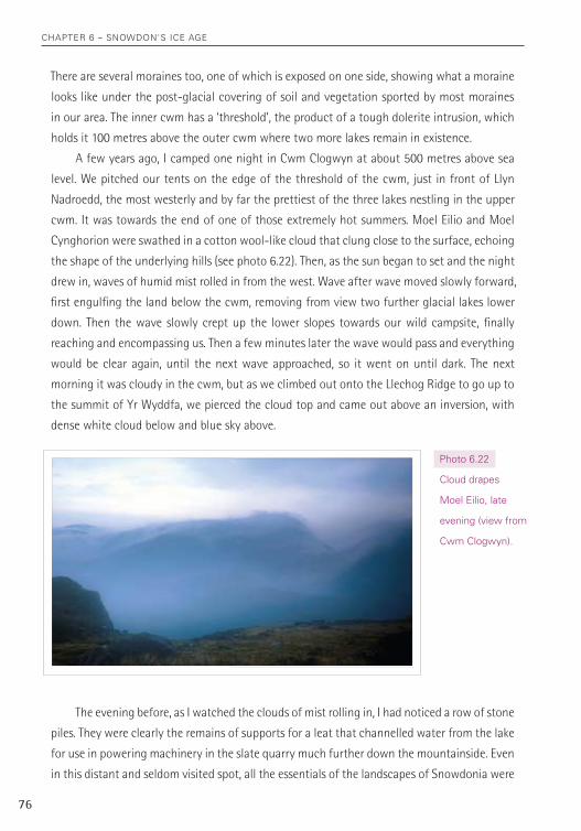
cwm. It was towards the end of one of those extremely hot summers. Moel Eilio and Moel
Cynghorion were swathed in a cotton wool-like cloud that clung close to the surface, echoing
the shape of the underlying hills (see photo 6.22). Then, as the sun began to set and the night
drew in, waves of humid mist rolled in from the west. Wave after wave moved slowly forward,
first engulfing the land below the cwm, removing from view two further glacial lakes lower
down. Then the wave slowly crept up the lower slopes towards our wild campsite, finally
reaching and encompassing us. Then a few minutes later the wave would pass and everything
would be clear again, until the next wave approached, so it went on until dark. The next
morning it was cloudy in the cwm, but as we climbed out onto the Llechog Ridge to go up to
the summit of Yr Wyddfa, we pierced the cloud top and came out above an inversion, with
dense white cloud below and blue sky above.
photo 6.22
cloud drapes
Moel eilio, late
evening (view from
cwm clogwyn).
The evening before, as I watched the clouds of mist rolling in, I had noticed a row of stone
piles. They were clearly the remains of supports for a leat that channelled water from the lake
for use in powering machinery in the slate quarry much further down the mountainside. Even
in this distant and seldom visited spot, all the essentials of the landscapes of Snowdonia were
chapter 6 – Snowdon'S Ice age
77
visible – from evidence of volcanoes to the effects of glaciation, from weathering and erosion
caused by the atmosphere, to the influence of human beings.
Snowdon’s glacial cwms and the glacial trenches, such as the Llanberis Pass, are evidence
that short term fluctuations of climate can affect the landscape as much as the great tectonic
events. Vast volumes of rock were carried away by the glaciers, with ‘erratics’ from central
Snowdonia carried as far as Anglesey.
The melting of the great valley glaciers has left the sides of the unveiled gorges pock-
marked with ‘hanging valleys’ (at the height where their smaller glaciers flowed into the
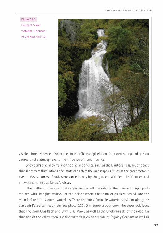
main ice) and subsequent waterfalls. There are many fantastic waterfalls evident along the
Llanberis Pass after heavy rain (see photo 6.23). Slim torrents pour down the sheer rock faces
that line Cwm Glas Bach and Cwm Glas Mawr, as well as the Glyderau side of the ridge. On
that side of the valley, there are fine waterfalls on either side of Esgair y Ceunant as well as
photo 6.23
ceunant Mawr
waterfall, Llanberis.
photo reg atherton
chapter 6 – Snowdon'S Ice age
78
alongside the track between Llyn y Cwn (between Glyder Fawr and Y Garn) and Nant Peris.
The waterfalls may be almost inconspicuous in dry weather, but after a spell of rain they
command the attention of the walker as they pour out of their hanging valleys and down the
hillsides in white torrents.
The descent of the Llanberis Pass – best of all on foot – ranks with a journey down
through Scotland’s Glencoe in drama and portent. The mass of rubble and scree that litters
the slopes of the gorges, most conspicuously near Pen y Pass on the north-eastern side of the
Pass, has all fallen since the glaciers melted (see photos w11.2 and w11.3). These scree slopes
of the upper reaches of the Llanberis Pass almost seem like an echo of the quarry waste at the
lower end of the Pass – nature’s own quarry waste tips (Walk 11).
The cliffs here are today popular with climbers, presenting them with airy, exhilarating
climbs. Some of the fallen blocks have also become popular with exponents of a variant of the
climber’s art, ‘bouldering’. Boulderers can frequently be seen clinging to the massive blocks
of rock, and which edge out onto the road, just south of the road bridge, Pont y Gromlech.
These massive blocks are examples of one of the characteristic ‘Lower Rhyolitic Tuff’ rocks
(breccia) and are well worth close examination – which can of course be carried out from a
safe position standing on the ground and without the need to involve the spider-imitating,
gravity-defying postures of boulderers (see photo 4.2).
Climbing has its fashions. A few years back it was other cliffs that were popular – the
Idwal Slabs or Cwm du’r Arddu, for example. Perhaps even within the lifetime of this book the
climbers will seek out newer challenges elsewhere. Whatever the developments of climbing
fashion, on a longer time scale, the fallen rocks of the Llanberis Pass will be available for
inspection for a long time to come. However, even that time period will come to an end if
another ice age does come and glaciers return to this area. Then all those massive blocks of
rock littering the slopes of the Llanberis Pass and other major troughs will be swept away like
crumbs from the table and the shape of the landscape will be wrought anew.
Llyn Llyn Llyn CweLlynCweLlynCweLlynCweLlynCweLlyn
Llyn Llyn PPadarnadarn
Llyn Llyn PPeriseriseris
MarMarMarcchlynhlynhlynMawrMawr
MarMarchlynhlynBaBacchh
Llyn y MynyddLlyn y Mynydd
Llyn yLlyn yGaderGader
Llyn Llyn Llyn DwythwDwythwDwythwDwythwcch
Elidir FawrElidir FawrElidir Fawr
LlanberisLlanberisLlanberisLlanberisLlanberisLlanberis
Rhyd-DduRhyd-DduRhyd-DduRhyd-DduRhyd-DduRhyd-Ddu
A5A5
A4086A4086
A4086A4086A4086A4086A4086A4086A4086
A424
4
A4085A4085
Moel EilioMoel EilioMoel EilioMoel EilioMoel Eilio
Carnedd y FiliastCarnedd y FiliastCarnedd y FiliastCarnedd y FiliastCarnedd y FiliastCarnedd y FiliastCarnedd y FiliastCarnedd y FiliastCarnedd y FiliastCarnedd y FiliastCarnedd y FiliastCarnedd y FiliastCarnedd y Filiast
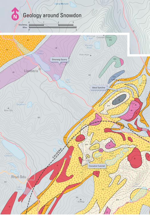
(MG) Microgranite
(IR) Intrusive Rhyolite
(B) Basalt Lava
(URT) Upper Rhyolitic Tuffs
(BPF) Bedded Pyroclastic Formation
(LRT) Lower Rhyolitic Tuffs
(PHT) Pitts Head Tuffs
(D) Dolerite Intrusion
(CCV) Capel Curig Volcanics
(SD) Sedimentary Rocks
(LB) Llanberis Slates
(PT) Padarn Tuffs
MGMG
IRIR
LBLB
PTPT
PTPT
DD
CCVCCV
SDSD
PHTPHT
BB
URTURT
LRTLRT
BPFBPF
BPFBPF
BPFBPF
BPFBPF
MGMG
IRIR
IRIR
IRIR
IRIR
IRIR
IRIR
IRIR
IRIR
IRIR
IRIR
DD
DD
DD
DD
DD
DD
DD
DDDD
CCVCCVSDSD
SDSD
SDSD
SDSD
SDSD
SDSD
SDSD
LBLB
PHTPHT
PHTPHT
PHTPHT
LRTLRT
LRTLRT
LRTLRT
LRTLRT
LRTLRT
CA
LDER
A
CALD
ERA
Heather Terrace
Dinorwig Quarry
Idwal Syncline
Geology around Snowdon
Snowdon Summit
SNOWDON VOLCANIC GROUP(ORDOVICIAN)
LLEWELYN VOLCANIC GROUP(ORDOVICIAN)
CAMBRIAN
CAMBRIAN & ORDOVICIAN
Kilometres1 2 30
Miles0 2

9 7 8 1 9 0 6 0 9 5 0 4 8
isBn 978-1-906095-04-8
SnowdoniaThe origins of the magnificent scenery of Snowdonia explained, and a guide to some
great walks which reveal the grand story of the creation of such a landscape.
Continental plates collide; volcanoes burst through the earth’s crust; great flows of ash
and molten rock pour into the sea; rock is strained to the point of catastrophic collapse;
and ancient glaciers scour the land. Left behind are clues of these awesome events, the
small details will not escape you, all around are signs, underfoot and up close.
Paul leads you on a series of thirteen walks on and around Snowdon, including the
Carneddau, the Glyders and Tryfan, Nant Gwynant and the Llanberis Pass. Each walk
reveals fascinating evidence of geological upheaval, and spectacular views of the very
best scenery of Snowdonia.
a hillwalker’s guide to the geology & scenery