Embed Size (px)
Citation preview
Satellite Transit Center Study FINAL: May 2009
Prepared for the
Rochester Genesee Regional Transportation Authority (RGRTA)
by


RGRTA Satellite Centers Study
Executive Summary Page 1
Executive Summary
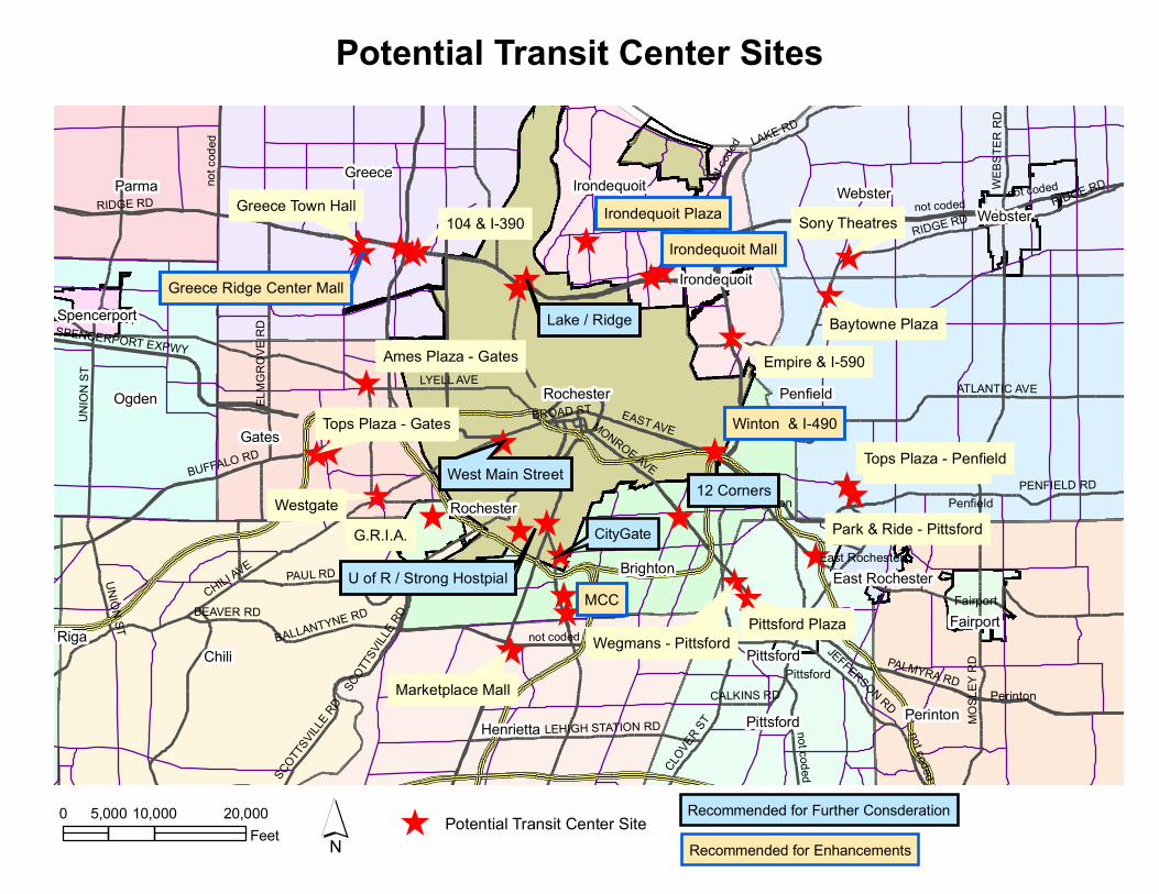
An evaluation of the viability of 19 potential sites to serve as a satellite transit center addressed the following criteria:
• Transit functionality (routes, ridership)
• Market assessment (proximity to residences and activity‐generators; commercial potential)
• Site suitability (vehicular and pedestrian access; availability of land)
• Partnership opportunities
Four sites were selected for further consideration: Mt. Hope Station (Strong Hospital); West Main Street; Brighton 12 Corners and CityGate. The potential for the Lake/ Ridge site to be developed for transit in conjunction with economic development should be addressed in a future study. Six sites were recommended for enhancements:
• Medley Centre (Irondequoit)
• Irondequoit Plaza (Irondequoit)
• Greece Ridge Mall (Greece)
• Marketplace Mall (Henrietta)
• Monroe Community College (Brighton)
• Winton Road/ East Avenue (Rochester)
In addition to sufficient platform loading space for buses, the satellite transit center design needs to include indoor waiting area, ticket booth or kiosk, real‐time bus schedule information video security system, benches, bicycle lockers, trash receptacles, pedestrian access, parking and landscaping. A building of approximately 10,000 square feet is recommended to accommodate ancillary commercial or service uses in addition to space for passenger waiting and ticket sales. Anticipated costs include land acquisition, demolition and site preparation, site development, construction, and design/legal/ administrative fees.
Mt. Hope Station
The preferred site would be part of the proposed “Collegetown” development on the east side of Mt. Hope Avenue between Crittenden Blvd. and Elmwood Ave. Alternative sites are located along the west side of Mt. Hope Ave. and the south side of Crittenden Blvd. A transit center at Strong would need to require loading space for 8 buses at any one time. Four alternative conceptual designs for the Collegetown site and one each for the two alternative locations were prepared. Costs are estimated at $8‐9 million. Joint development is encouraged in conjunction with the private development of Collegetown.

RGRTA Satellite Centers Study
Executive Summary Page 2
West Main Street
The preferred site is located at Bullshead Plaza, located southwest of the intersection of West Main and Genesee Streets. A transit center in this location would require four bus bays. Several off‐street and on‐street designs were considered. The most effective design from a transit operations perspective would require the demolition of a portion of the Bullshead plaza building. Costs are estimated at $14 million.
Brighton 12 Corners
Enhanced bus shelters are recommended, utilizing Town‐owned land in the “triangle” at the center of 12 corners. Custom designed and constructed shelters are recommended.
CityGate
A transit center with three bus bays is recommended to be constructed in conjunction with a parking structure. A joint development agreement with the developer of CityGate is recommended.
RGRTA Satellite Centers Study
i
NARRATIVE REPORT Table of Contents
Study Objectives ....................................................................................................................................................................... 1
Methodology .............................................................................................................................................................................. 1
Site Evaluation .......................................................................................................................................................................... 1
Joint Development Considerations .................................................................................................................................. 9
Site Design ................................................................................................................................................................................ 10
Strong/ University of Rochester ...................................................................................................................... 10
West Main Street/ Unity Health (formerly St. Mary’s Hospital) ........................................................ 22
Brighton 12 Corners ............................................................................................................................................. 30
CityGate ...................................................................................................................................................................... 32
Cost Estimates ......................................................................................................................................................................... 33
Next Steps ................................................................................................................................................................................. 38
List of Figures
1. Potential Satellite Transit Centers Sites .................................................................................................... 2 2. Recommended Sites .......................................................................................................................................... 8 3. Existing Transit Ridership – Mt. Hope Station Site ............................................................................ 12 4. Proposed Designs: Mt. Hope Station Options A, B, C & D .............................................................. 15 5. Alternative Site locations .............................................................................................................................. 18 6. Site Designs for Alternative Locations ................................................................................................... 19 7. Land Use by Tax Parcel – Strong ............................................................................................................... 20 8. Population Characteristics – Mt. Hope Station site ............................................................................ 21 9. Transit Activity –West Main Street .......................................................................................................... 23 10. Main Street Options Summary ................................................................................................................... 25 11. Land use by tax parcel – West Main Street ........................................................................................... 27 12. Population Characteristics – West Main Street ................................................................................... 28

RGRTA Satellite Centers Study
Narrative Report ii
Appendices A: Summary of 1998 Satellite Centers Feasibility Study
B: Transit Ridership Maps
C: Transit Activity & Capital Cost Considerations at 19 Candidate Satellite Center Locations
D: Land Use Maps
E: Aerial Photographs
F: Site Evaluation Summaries
G: Correspondence regarding potential City of Rochester sites
H: Transit Center Descriptions
• Mt. Hope Station
• West Main Street
• 12 Corners
• CityGate

RGRTA Satellite Centers Study
1
NARRATIVE REPORT STUDY OBJECTIVES
The impetus for the Satellite Transit Centers study originated in the 1995 Long Range Transportation Plan that was prepared by the Genesee Transportation Council for the Greater Rochester area. In order to broaden the appeal of transit and improve its overall quality and marketability, the Long Range Plan recommended the establishment of satellite transit centers to facilitate transit usage between locations outside of downtown Rochester. Such centers would include an enclosed structure that provides heated shelter, a comfortable and secure waiting area, Park & Ride parking where feasible, pedestrian access and route and schedule information. They should also incorporate or be located near activity centers or retail or service‐oriented businesses.
METHODOLOGY In December 2007, the Rochester Genesee Regional Transportation Authority (RGRTA) contracted with the team of Stuart I. Brown Associates and Nelson\Nygaard to:
• evaluate the feasibility of 19 potential sites to serve as satellite transit centers
• evaluate RTS routes and recommend changes that would maximize the viability of the preferred sites to function as transit centers, and
• prepare conceptual designs and cost estimates for the most viable sites.
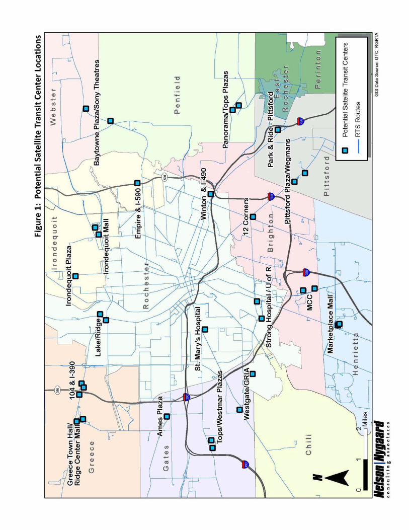
SITE EVALUATION A total of 19 potential sites were evaluated for their viability of to serve as satellite transfer centers (see Figure 1: Potential Satellite Transit Centers Sites). Findings from a 1998 study of the same 19 locations were reviewed. (See Appendix A: Summary of 1998 Satellite Centers Feasibility Study.) The objective of the evaluation was to identify the most promising sites for further consideration and preliminary design.
The following criteria were utilized in the evaluation:
• Transit functionality: Number of routes serving the site; current transit usage and the potential for transit to effectively serve the site

RGRTA Satellite Centers Study
Narrative Report 2
• Market Assessment: Proximity to existing commercial and services uses; market for such uses from surrounding neighborhood (residents, employees)
• Site Suitability: Vehicular access; availability of land
• Opportunities for partnership
This section includes a summary of the transit analysis, the market assessment and site suitability, potential for partnerships, site design alternative and recommendations.
Transit Functionality
The initial analysis of transit functionality documented the number of routes serving the site, the number of times per day that buses stop at the site, and the extent of passenger activity (boarding and alighting). A series of maps depicts the existing RTS routes that serve each of the proposed sites and the total number of boardings and alightings at each existing bus stop. (See Appendix B: Transit Ridership Maps.)
The analysis also estimated the number of bus bays that would be required, based on the number of buses that would serve the site at any one time. Based on the number of bays, the relative capital cost of constructing a transit center at each site was characterized as high, medium or low. The findings are summarized in Appendix C: Transit Activity & Capital Cost Considerations at 19 Candidate Satellite Center Locations.
RGRTA Satellite Centers Study
Narrative Report 4
The analysis concluded that the following eight sites have the greatest potential to serve as satellite transit centers, based solely on transit functionality:
Toptier Candidate Location
1. Strong / U of R
Recommended for Further Consideration
2. St. Mary’s Hospital (West Main Street) 3. Irondequoit Plaza 4. Winton Road & I‐490 5. Lake & Ridge 6. MCC 7. Greece Ridge Mall 8. Medley Centre
Market Assessment and Site Suitability Analysis
The Market Assessment and Site Suitability Analysis evaluated the potential market for ancillary services that might be collocated with a transit center. This analysis included: an overview of land use within one‐half mile of each of the proposed sites; a qualitative determination of the customer base from nearby residences, employees and other trip generators; and an assessment of vehicular and pedestrian traffic at each site.
The analysis included a characterization of neighboring parcels based on the land use classification of tax parcels. Maps of the land use surrounding each of the proposed sites are included in Appendix D: Land Use Maps. Aerial photographs of each site overlaid with parcel boundaries are included in Appendix E: Aerial Photographs.
A summary of the market assessment and site suitability analysis is provided in Appendix F: Site Evaluation Summaries.
Partnership Opportunities
RGRTA and its consultants contacted potential partners to determine whether opportunities were available for joint development. As a result of this outreach, an additional potential site was identified at the site of a new mixed use development along Westfall and East Henrietta Street in the City of Rochester (CityGate). The developer of this property, Anthony Costello & Son, expressed interest in collaborating with RGRTA to incorporate transit into the design of the site, potentially in conjunction with a parking structure at the site.
The Town of Brighton also expressed interest in working with RGRTA to enhance transit functionality in the Town in conjunction with the Town’s “green” initiative. Suggested sites were 12 Corners and the Brighton Town Hall/ Library.
RGRTA Satellite Centers Study
Narrative Report 5
Outreach to the City of Rochester economic development office resulted in a list of developers to contact and a suggestion that the Lake‐Ridge site appeared to be most promising for joint development. Copies of the correspondence with the City of Rochester is included in Appendix G.
Sites Recommended for Detailed Evaluation and Design
Enhancements are recommended for several additional sites to improve their ability to serve as satellite transit centers.
Based on the transit analysis, market assessment and evaluation of partnership opportunities, five sites were recommended for more detailed evaluation and design.
• Strong Hospital • West Main Street • Lake & Ridge • Town of Brighton (12 Corners or Brighton Town Hall/ Library) • CityGate
Strong Hospital would make an excellent site for a satellite transit facility due to its very high level of transit activity, large trip generators within the site area, and excellent pedestrian access. Linkages with regional bus systems as well as the University of Rochester shuttle bus system would also be possible at this location.
West Main Street at Genesee (former St. Mary’s Hospital) would make a very good site for a satellite transit facility for three principal reasons. First, the site has a very high level of transit activity. Second, most of the area encompassed within the site radius is comprised of high‐density residential uses. Third, a very large portion of the site radius contains high density residential neighborhoods with excellent access the core of the site area. A lack of vacant land represents the most significant constraint.
Brighton 12 Corners has moderate potential for a satellite transit facility. Principal limitations are the lack of converging bus routes and the limited amount of undeveloped land. However, a potential partnership with the Town of Brighton may warrant the establishment of upgraded transit facilities to encourage additional transit use among Town residents and employees. In addition, major trip generators include the Brighton High School and Middle School and a concentration of retail, restaurants and service uses. Buses serving this location travel directly to downtown Rochester (#7) and Strong Hospital (#18‐19) and connect 12 Corners with the Brighton Town Hall and Library.
The CityGate site is located near Strong Hospital and Monroe Community College and has the potential to serve as a hub for suburban commuters. The site currently is used as a parking lot for the University of Rochester shuttle buses; this function is expected to continue as part of the proposed development.

RGRTA Satellite Centers Study
Narrative Report 6
Site Recommended for Additional Study
The Lake Avenue/ Ridge Road site would be a moderately good site for a satellite transit center, due to the number of converging routes and proximity to several large trip generators (Kodak, Marshall High School, Sacred Heart School). Large areas of vacant and underutilized land are available. This area also has excellent visibility as well as access to neighboring suburbs via Route 104.
Detailed site analysis and designs for a satellite transit center at the Lake Avenue/ Ridge Road site is recommended for a subsequent study. Transit development at this site has the potential to catalyze economic development in this area.
Sites Recommended for Transit Enhancements
Several sites, although not among the top‐tier candidates for a satellite transit center, are significant transit destinations and/or transfer sites and would benefit from enhancements to existing transit facilities. Such enhancements may include larger shelters with amenities such as heat or real‐time bus arrival information, improvements to pedestrian circulation and linkages to services. Such enhancements would encourage transit use provide more comfortable waiting areas.
The following sites are recommended for enhancements:
• Former Medley Centre (Irondequoit) • Irondequoit Plaza (Irondequoit) • Greece Ridge Mall (Greece) • Marketplace Mall (Henrietta) • Monroe Community College (Brighton) • Winton Road/ East Avenue (Rochester)
The former Medley Centre, as it may be redeveloped, is expected to be a moderately good site for a satellite transit facility to serve employees and patrons of the facility and nearby businesses. The existing bus stop in this area has functioned as a transit center where bus riders can transfer from one route to another. The site would be suitable for a Park & Ride lot, but has poor pedestrian accessibility.
The Greece Ridge Mall site is a moderately good site for a satellite transit facility principally due to the number of bus routes that converge within the site radius. The existing bus stop on the Greece Ridge Mall property currently functions as a transfer facility where bus riders may transfer from one route to another. Greece Ridge Mall, Buckman Plaza, and Ridgemont Plaza and numerous retail and service businesses along Ridge Road create a major retail hub. A network of sidewalks connects the Mall to neighboring commercial residential areas.

RGRTA Satellite Centers Study
Narrative Report 7
The Marketplace Mall site would make a fair site for a satellite transit facility in view of the moderate number of converging bus routes and moderate number of bus movements within the site radius. However, pedestrian access between the Mall and neighboring properties is poor. A partnership with the owners of Marketplace Mall would be required to enhance transit facilities at the site.
The Monroe Community College (MCC) site would make a reasonably good site for a satellite transit facility, as five bus routes converge on the site. MCC and the ESL Sports Centre are major trip generators within this site area which also contains office parks and a large apartment complex. However, lack of sidewalks and street crossings limit pedestrian access to nearby residential commercial areas. MCC currently provides a comfortable indoor waiting area at the existing bus stop on the campus.
The Irondequoit Plaza site is well suited for a satellite transit facility. Not only did the site area receive a high transit activity score, but it is also readily accessible by pedestrians and motor vehicles. The existing bus stop at Irondequoit Plaza currently serves as a transit center in partnership with the Plaza’s owner. A relatively high density of commercial and residential uses are within walking distance of the site via a good sidewalk network.
The Winton Road/ East Avenue site is fairly well suited for a satellite transit facility due to a relatively high level of transit activity. A Wegman’s supermarket, which is proposed to be expanded, is a major trip generator. Top’s Market and Harris Communications are located nearby. However, the lack of vacant land and barriers to pedestrian access severely limit the locations where a transit facility could be sited. A partnership with Wegman’s would likely be needed to establish a transit center in this area.
Figure 2 identifies those sites recommended for consideration as a satellite transit center as well as those recommended for transit enhancements.
^̂
^̂
^ ^ ^
^̂
^̂^̂
^
^̂
^̂
^̂
^
^
^
^^
^̂^
^
^̂̂
^CityGate
PerintonPittsford
Penfield
Fairport
Mendon
Brighton
Pittsford
East Rochester
MCC
G.R.I.A.Westgate
12 Corners
Lake / Ridge
Sony Theatres
Westmar Plaza
Baytowne Plaza
Empire & I-590
Winton & I-490
Pittsford Plaza
Marketplace Mall
Ames Plaza - Gates
West Main Street
Wegmans - Pittsford
U of R / Strong Hostpial
104 & I-390
Panorama Plaza
Greece Town Hall
Irondequoit MallIrondequoit Plaza
Tops Plaza - GatesTops Plaza - Penfield
Park & Ride - Pittsford
Greece Ridge Center Mall
Chili
Penfield
Greece
Rochester
Perinton
Webster
Henrietta
Gates
Ogden
Pittsford
Brighton
Parma Irondequoit
Irondequoit
Webster
FairportRiga
Rochester
Spencerport
East Rochester
Pittsford
UNIO
N ST
BUFFALO RD
EAST AVE
CLOVE
R ST
not coded
RIDGE RD
CHILI AVE
MONROE AVE
ATLANTIC AVE
JEFFERSON RD
ELMG
ROVE
RD
LYELL AVE
MOSL
EY R
D
LAKE RD
SPENCERPORT EXPWY
PENFIELD RD
LEHIGH STATION RD
PALMYRA RDSCOTT
SVILL
E RDBEAVER RD
WEBS
TER
RD
BALLANTYNE RD
CALKINS RD
BROAD ST
PAUL RD
SCOTTS
VILLE
RD
RIDGE RDnot coded
RIDGE RD
UNION ST
not codedno
t cod
ed
not co
ded
not coded
not coded
´0 10,000 20,0005,000Feet
Potential Transit Center Sites
^ Potential Transit Center Site Recommended for Further Consderation
Recommended for Enhancements

RGRTA Satellite Centers Study
Narrative Report 9
JOINT DEVELOPMENT CONSIDERATIONS The Rochester Genesee Regional Transportation Authority (RGRTA) may entertain proposals from a private developer to construct a transit center as a “joint development.” According to Federal Transit Agency (FTA) guidelines, “joint development” is a commercial, residential, industrial or mixed‐use development that is induced by or enhances the effectiveness of transit projects. For certain projects, RGRTA may be able to obtain Federal transportation funds to be used for “joint development” projects carried out in partnership between RGRTA and a private developer. RGRTA would need to acquire the land, at least initially, and complete the required environmental reviews before initiating the project.
In order to be eligible for cost‐sharing through the joint development process, a project must:
• Enhance the effectiveness of a mass transit project, and be related physically or functionally to the transit project. A project is physically related if it provides a direct physical connection with transit services or facilities, including development adjacent to or using air space above transit facilities. A project is functionally related if it provides a beneficial service to the public and enhances use of or access to transit. Functionally‐related projects must be located within approximately 1,500 feet from the center of a transit facility.
• Establish new or enhanced coordination between mass transit and other forms of transportation
• Provide a fair share of the revenue for transit use.
Eligible costs may include:
• Design, engineering and environmental analysis
• Site preparation
• Foundations and substructure improvements for buildings over transit facilities
• Open space and pedestrian connections and access links between transit services and related development
• Other facilities and infrastructure investments needed to induce significant private investment and to improve access between new or existing development and transit facilities.
• Utility work, provided that the utility services a joint private and transit use, or when the utility lines will be located under a co‐located street or sidewalk or within other common elements so that it would benefit the project to provide adequate capacity at the outset of the project.
RGRTA Satellite Centers Study
Narrative Report 10
• Safety and security equipment and facilities (including lighting and surveillance)
• Facilities that incorporate community services such as daycare or health care.
• Parking elements that have a public transit justification and use.
Development of a transit center as a joint development may provide benefits to both RGRTA and a private developer. Integrating transit into the site design would improve mobility of residents and customers and attract people to retail businesses that may be incorporated into the adjoining development. RGRTA would receive revenue to support transit use.
SITE DESIGN Transit center descriptions, design guidelines and cost estimates were prepared for the following sites:
• Strong/ University of Rochester • West Main Street • Brighton – 12 Corners • CityGate
Additional descriptions and images of the proposed site designs are included in Appendix H: Transit Center Descriptions.
STRONG/ UNIVERSITY OF ROCHESTER Strong Hospital and the University of Rochester comprise Monroe County’s largest employer. Several transit routes currently converge near Strong Hospital. An off‐street area on the campus of Strong, near the main entrance, currently functions as a small transit center.
Representatives of RGRTA and its consultants met with the University of Rochester’s Facilities Manager to determine whether there may be an opportunity to collaborate on a transit center near Strong Hospital. Such a facility has the potential to increase the use of transit among employees and visitors to Strong Hospital, and thereby reduce the need for additional parking.
The preferred site, designated “Mt. Hope Station,” is located northwest of the intersection of Mt. Hope Avenue and Crittenden Boulevard. The site was formerly a Wegman’s supermarket and is now owned by the University of Rochester and used as a parking lot. The University intends to make this land available for private development as a “Collegetown,” featuring mixed residential and commercial uses. A transit center is envisioned in conjunction with the development of a parking structure that would be part of the private “Collegetown” development. Partnership with the University of Rochester/ Strong Hospital would be needed.
Alternative sites are located along Mt. Hope Avenue and Crittenden Avenue.
RGRTA Satellite Centers Study
Narrative Report 11
Transit Functionality
This location is served by seven RTS bus routes and two campus shuttles sponsored by the University of Rochester. Three routes operate seven days per week and six operate on weekdays only. The Mt. Hope Station transit center would serve approximately 902 RTS riders per day, in addition to riders who utilize the Iola parking shuttle and the University of Rochester’s campus shuttles. The daily ridership for the transit stops in the vicinity of Mt. Hope Station is summarized in Figure 3: Existing Transit Ridership – Mt. Hope Station Site.
RTS Bus Routes
• #5 – South Avenue – provides radial local service between downtown Rochester and Monroe Community Hospital (MCH) seven days per week. Currently, selected weekday trips and all weekend trips run on Crittenden in both directions past the site, using the Strong entrance loop to the west to turn around. It is likely that all #5 trips will be rerouted to the Mt. Hope Station Transit Center if constructed.
• #8 – Chili / Strong – provides radial local service between downtown Rochester and destinations in the 19th Ward and the Town of Chili seven days a week. Strong Hospital is the terminal point for one branch of the route, and approximately half of all trips operate via Elmwood EB and Crittenden WB to the hospital.
• #12 – 19th Ward / MCC – provides crosstown local service between the primarily residential neighborhoods of the 19th Ward and institutional destinations situated on opposite sides of the Genesee River, including the University of Rochester campus, Strong Memorial Hospital, Monroe Community Hospital, and Monroe Community College. The weekday‐only schedule consists of five trips in each direction running at hourly intervals primarily during commute hours.
• #18/19 – University – provides radial local service between downtown Rochester and the Browncroft‐Winton area in the City of Rochester via University Avenue, as well as crosstown local service between Browncroft and the University of Rochester campus via 12 Corners and Elmwood Avenue in the Town of Brighton. The route currently terminates at the University of Rochester. If a new off‐street facility is constructed at Mt. Hope and Crittenden, relocation of the #18 layover point should be considered.
• #24 – Marketplace Mall / RIT / Scottsville – provides radial local and limited express service between downtown Rochester and various destinations in Henrietta and Scottsville. The route passes the site on Mt. Hope in both directions and continues south via East Henrietta.
• #50 – MCC – provides radial local service between downtown Rochester and Monroe Community College on weekdays only. Most trips run on Mt. Hope and West Henrietta Road.

Stop Name Direction Boardings Alightings TotalStrong Hospital Loop Walk Pavilion N 481 237 718East Dr & Elmwood W 23 59 82E Henrietta & Fort Hill N 38 25 63Mt Hope & Crittenden S 6 44 50Mt Hope & 1351 Mt Hope S 11 38 49
Strong Hospital/UR Top Five Stops
Figure 3
Existing Transit Ridership—Mt. Hope Station Site
NOTE: Ridership based on September 2008 counts.

RGRTA Satellite Centers Study
Narrative Report 13
• #91 – Avon / Suburban Plaza – provides radial local and limited express service between downtown Rochester and various destinations in the Town of Henrietta on weekdays. Selected peak period trips extend south to include Rush, Honeoye Falls, Lima, East Avon and Avon. Most trips run on South Avenue and East Henrietta Road, although two trips in each direction run on Mt. Hope Avenue and West Henrietta. It is likely that all #91 trips will be rerouted to the Mt. Hope Station Transit Center if constructed.
University of Rochester Shuttles
In addition to RTS service, the intersection of Mt. Hope and Crittenden is served potentially by two shuttle routes sponsored by the University of Rochester and operated by a contract service provider (First Transit).
• IOLA Shuttle – provides remote parking shuttle service every 20 minutes from 6:10 am until 6:10 pm between the CityGate property (East Henrietta and Westfall) and the Crittenden (Hospital South) Loop. This shuttle passes the project location in both directions on Crittenden
• Blue Line – provides shuttle service between the River campus, Strong Hospital, University Park and Whipple Park seven days per week. The route currently runs eastbound on Elmwood, south on East Hospital Drive and west on Crittenden; however, it is assumed that it could be extended to the Mt. Hope location at nominal additional operating expense.
Site Design
The Mt. Hope Station Transit Center needs to accommodate a total of 8 bus stops aligned in either a “sawtooth” or inline formation; benches and bus stop signs at each stop; an indoor waiting area with restrooms, ticket kiosks, real‐time bus schedule information, and seating areas with visibility to bus platforms; video security system, benches, bicycle lockers and trash receptacles. Design Guidelines are included in Appendix H: Mt. Hope Station.
Four potential design concepts suggest how the transit center would be integrated with a larger mixed‐use development on the preferred site. Each of the four proposed conceptual design layouts utilizes a central access road that connects Mt. Hope Avenue to the main Strong Hospital campus. The intersection at Mt. Hope Avenue would be signalized as proposed in the City of Rochester’s plans for the reconstruction of Mt. Hope Avenue. The proposed layout on the site is intended to utilize a natural change in elevation to support the construction of a parking garage or other development above the transit facility. Illustrations of the proposed designs are summarized in Figure 4 and are included in Appendix H: Mt. Hope Station.

RGRTA Satellite Centers Study
Narrative Report 14
Option A features a loop configuration with 8 sawtooth or in‐line bus stops around an island; a stand‐alone transit center building with 2,000 sq. ft. on island near access road. The bus platforms, building and travel lanes occupy approximately 36,500 sq. ft.
Option B orients the bus stops in a linear configuration to the rear of a proposed retail strip. The transit center would occupy one of the storefronts (approximately 2,000 sq. ft.). The bus platforms, buildings and travel lanes occupy approximately 94,080 sq. ft. in a linear arrangement. A parking structure or other development may be constructed above the bus platforms.
In Options C and D, the main entranceway to Collegetown is configured to line up with the existing entrance to the Strong parking garage. In Option C, the bus stops are aligned in a loop with mixed use buildings to the west and north. The bus platforms, buildings and travel lanes would occupy approximately 70,000 sq. ft. In Option D, the bus stops are oriented in a linear configuration around an island. A mixed use building, to include approximately 2,000 sq. ft. for transit support is proposed to the west. The bus platforms, buildings and travel lanes would occupy approximately 70,000 sq. ft.

Figure 4: Site Design Concepts—Mt. Hope Station Site

RGRTA Satellite Centers Study
Narrative Report 16
If the preferred site is not available, a variation of Option C is recommended for Alternative Sites A (Mt. Hope Avenue) or B (Crittenden Blvd.) These alternative designs incorporate parking for the associated retail or service businesses.
Figure 5 depicts the two alternative site locations. Figure 6 illustrates how the design could be accommodated on the sites. Larger images are included in Appendix H: Mt. Hope Station.
Market Analysis
The primary market for ancillary retail or service development in conjunction with a transit center, in addition to transit consumers, includes residents and employees within ½ mile of the center. Based on 2000 Census data, approximately 3,334 persons reside in the approximately 1,213 households within a ½ mile radius of the proposed transit center site. Figure 7 depicts the land use by tax parcel in the vicinity of the proposed transit center. Figure 8 summarizes 2000 census data on the household income, age and racial characteristics of residents within ½ mile of the proposed transit center.
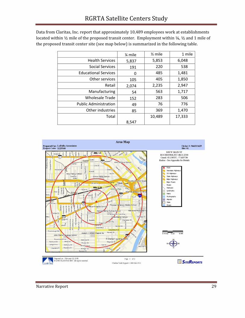
Data from Claritas, Inc. report that approximately 7,372 employees work at establishments located within ½ mile of the proposed transit center. Employment within ¼, ½ and 1 mile of the proposed transit center site (see map on the following page) is summarized in the following table.
¼ mile ½ mile 1 mile
Health Services 903 4,974 7,825 Educational Services 64 297 764 Social Services 179 596 729 Other services 142 463 1,331 Eating & Drinking Places 205 362 392 Other retail 34 130 209 Finance, Insurance, Real Estate 41 143 461 Other industries 58 407 4,242
Total 1,626 7,372 15,953
The University of Rochester reports that the total number of employees at Strong Hospital and the River Campus is approximately 24,000.

RGRTA Satellite Centers Study
Narrative Report 17

Figure 5
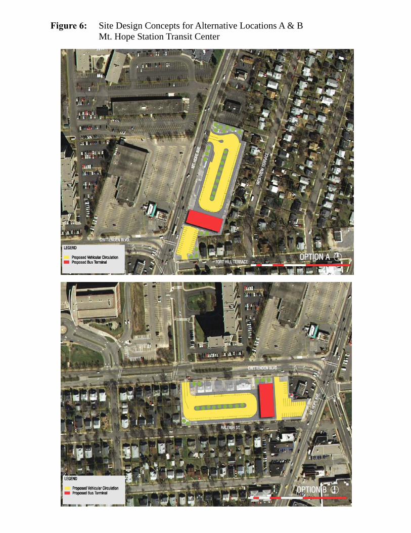
Figure 6: Site Design Concepts for Alternative Locations A & B Mt. Hope Station Transit Center

Figure 7 Land Use by Tax Parcel—Strong Hospital/ University of Rochester Site
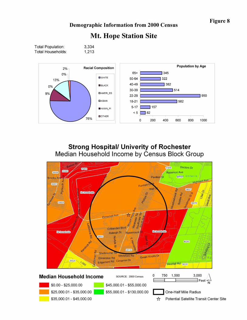
Figure 8
RGRTA Satellite Centers Study
Narrative Report 22
WEST MAIN STREET/ UNITY HEALTH (FORMERLY ST. MARY’S HOSPITAL) Transit Activity
The intersection of West Main and Genesee Streets/ Chili and West Avenues has more transit activity than any other location in the RTS system outside of downtown. Six bus routes serve this intersection:
• The #2‐Thurston stops 67 times per day on route between the Greater Rochester International Airport or the Wegmans Distribution Center and downtown, via Genesee Street and Main Street.
• The #4 Genesee stops 82 times per day along its route between Genesee Street and downtown.
• The #6‐Jefferson travels along Main Street and stops at Genesee Street 71 times each weekday.
• The #8‐Chili/ Strong bus stops at Genesee and Main 50 times each weekday on its route between downtown and either Strong Hospital or Chili.
• The #12‐19th Ward/ MCC bus stops at Genesee Street and Chili Avenue 12 times each weekday. Trips run in the morning and afternoon and connect to Strong Hospital and MCC.
• The #27‐Unity bus stops at St. Mary’s Hospital 14 times each weekday and connects to Park Ridge Hospital and Greece Ridge Center.
Average weekday boardings and alightings in this area total 1,326. Figure 9 summarizes the transit ridership at the bus stops in the vicinity of this intersection.
Site Design
Both on‐street and off‐street designs were considered. An overview of the existing conditions and design considerations are provided in the following narrative.
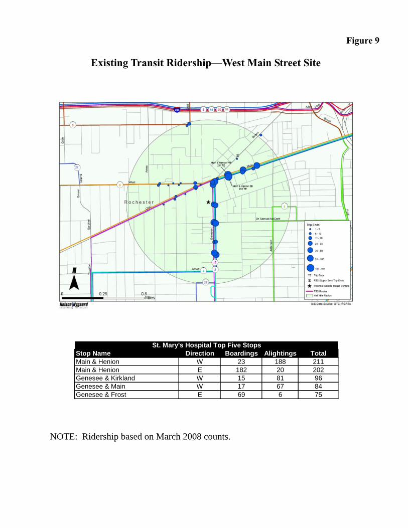
Figure 9
Existing Transit Ridership—West Main Street Site
NOTE: Ridership based on March 2008 counts.
Stop Name Direction Boardings Alightings TotalMain & Henion W 23 188 211Main & Henion E 182 20 202Genesee & Kirkland W 15 81 96Genesee & Main W 17 67 84Genesee & Frost E 69 6 75
St. Mary's Hospital Top Five Stops
RGRTA Satellite Centers Study
Narrative Report 24
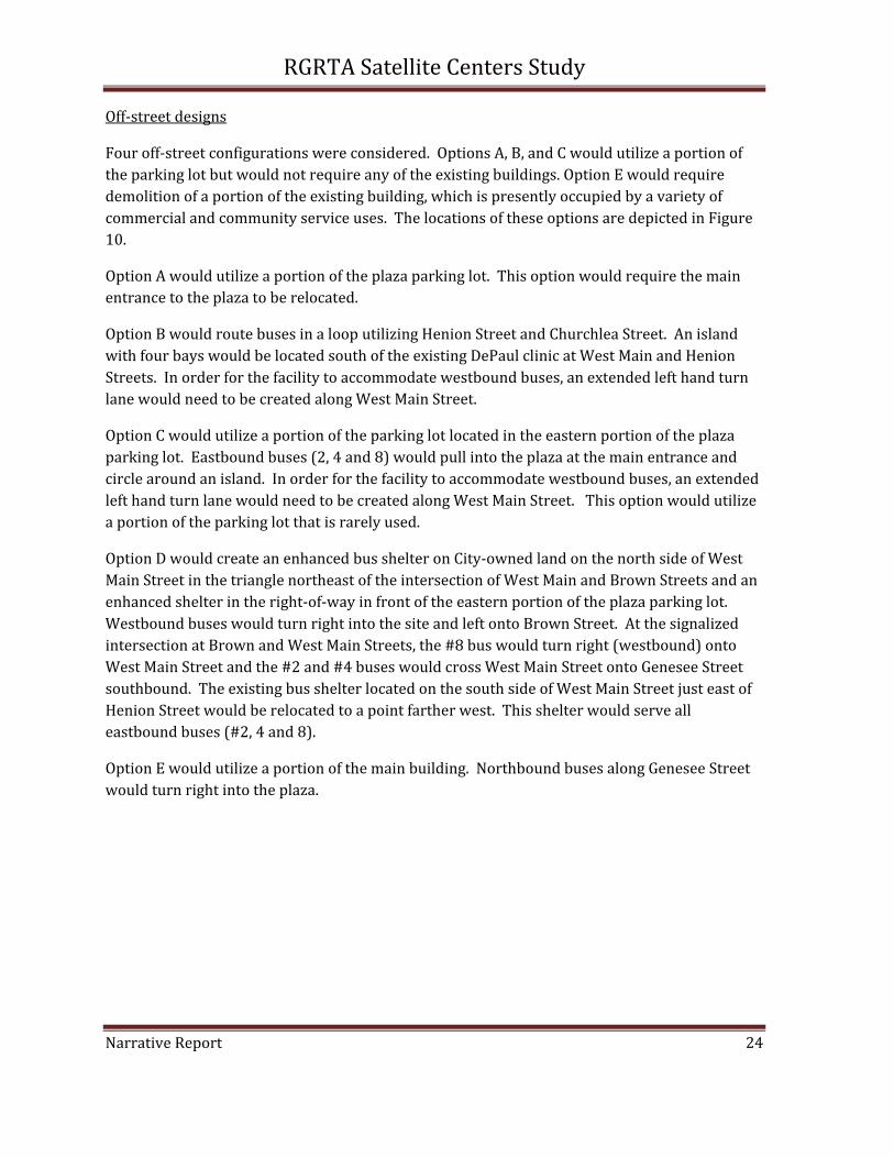
Off‐street designs
Four off‐street configurations were considered. Options A, B, and C would utilize a portion of the parking lot but would not require any of the existing buildings. Option E would require demolition of a portion of the existing building, which is presently occupied by a variety of commercial and community service uses. The locations of these options are depicted in Figure 10.
Option A would utilize a portion of the plaza parking lot. This option would require the main entrance to the plaza to be relocated.
Option B would route buses in a loop utilizing Henion Street and Churchlea Street. An island with four bays would be located south of the existing DePaul clinic at West Main and Henion Streets. In order for the facility to accommodate westbound buses, an extended left hand turn lane would need to be created along West Main Street.
Option C would utilize a portion of the parking lot located in the eastern portion of the plaza parking lot. Eastbound buses (2, 4 and 8) would pull into the plaza at the main entrance and circle around an island. In order for the facility to accommodate westbound buses, an extended left hand turn lane would need to be created along West Main Street. This option would utilize a portion of the parking lot that is rarely used.
Option D would create an enhanced bus shelter on City‐owned land on the north side of West Main Street in the triangle northeast of the intersection of West Main and Brown Streets and an enhanced shelter in the right‐of‐way in front of the eastern portion of the plaza parking lot. Westbound buses would turn right into the site and left onto Brown Street. At the signalized intersection at Brown and West Main Streets, the #8 bus would turn right (westbound) onto West Main Street and the #2 and #4 buses would cross West Main Street onto Genesee Street southbound. The existing bus shelter located on the south side of West Main Street just east of Henion Street would be relocated to a point farther west. This shelter would serve all eastbound buses (#2, 4 and 8).
Option E would utilize a portion of the main building. Northbound buses along Genesee Street would turn right into the plaza.

Rite-Aid
DePaul
W. Main St.
Henion St.
Churchlea St.
Family Dollar
Brown S
t.
Gen
esee
St.
Unity M
ental Health
Tax Parcel #120.50-2-2.002 Owner: Gorsline Crofts (Gorsline Management) Assessed Value: $1,700,000
Unity Health
West Main Street Transit Center Potential Transit Center Locations
C
B
A
D
D
Existing bus stop locations and route numbers
2,4,8
8 2,4,8
2,4,
27
2,4,
12,2
7
2,4,8
E
Figure 10

RGRTA Satellite Centers Study
Narrative Report 26
Options A, B and C face challenges with regard to circulation. Left turn lanes would need to be added along West Main Street to accommodate buses turning from westbound West Main Street into the transit center. Upon exiting the transit center, these buses would need to turn left again onto West Main Street. Turning into an off‐street transit center would also add to the time required to complete each route.
Creating an enhanced shelter at the City‐owned triangle land (Option D) would require rerouting westbound buses to Brown Street. The location would not work without rerouting the buses to Brown Street, as only the #8 bus continues westbound on West Main Street; the #4 and 8 buses turn left (southbound) onto Genesee Street. A new traffic signal would likely be needed at the intersection of the transit center and Brown Street that is coordinated with the signal at West Main Street, Brown Street and Genesee Street, as traffic currently backs up on Brown Street during red lights to a point farther northeast than the proposed egress onto Brown Street.
On‐street designs
As an alternative to the off‐street designs, enhanced shelters, custom‐designed and built, are recommended at the major bus stops near the intersection of Genesee Street and West Main Street. Examples of shelters that may be constructed in this area are included in Appendix H: West Main Street. A custom‐designed shelter is recommended.
In conjunction with the improved shelters, pedestrian crosswalks should be upgraded. A coordinated design should connect the facilities visually.
The stop at Henion Street should be relocated to the west, where a larger facility may be constructed. Features should include seating areas as well as real‐time bus arrival information and posted bus schedules.
Market Analysis
The primary market for ancillary retail or service development in conjunction with a transit center, in addition to transit consumers, includes residents and employees within ½ mile of the center. Based on 2000 Census data, approximately 7,671 persons reside in the approximately 2,834 households within a ½ mile radius of the proposed transit center site. Figure 11 depicts the land use by tax parcel in the vicinity of the proposed transit center. Figure 12 summarizes 2000 census data on the household income, age and racial characteristics of residents within ½ mile of the proposed transit center.
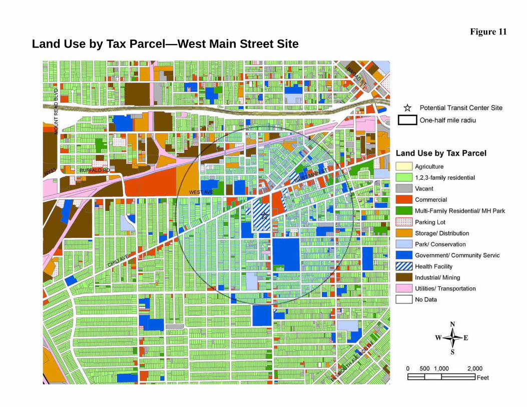
Figure 11 Land Use by Tax Parcel—West Main Street Site

Figure 12
West Main Street Site
RGRTA Satellite Centers Study
Narrative Report 29
Data from Claritas, Inc. report that approximately 10,489 employees work at establishments located within ½ mile of the proposed transit center. Employment within ¼, ½ and 1 mile of the proposed transit center site (see map below) is summarized in the following table.
¼ mile ½ mile 1 mile Health Services 5,837 5,853 6,048 Social Services 191 220 538
Educational Services 0 485 1,481 Other services 105 405 1,850
Retail 2,074 2,235 2,947 Manufacturing 54 563 1,717
Wholesale Trade 152 283 506 Public Administration 49 76 776
Other industries 85 369 1,470 Total
8,547 10,489 17,333

RGRTA Satellite Centers Study
Narrative Report 30
BRIGHTON TWELVE CORNERS The Town of Brighton has expressed interest in supporting transit enhancements as part of the Town’s “green” initiative. Three sites in the Town of Brighton were considered: Twelve Corners; Town‐owned land at the intersection of Monroe Avenue and St. Regis Drive, and the Brighton Town Hall/ Library.
The establishment of an off‐street transit center on Town‐owned land at either the Twelve Corners intersection, the Town Hall or at St. Regis Drive is not considered feasible. The following narrative outlines the rationale for this finding.
Brighton Town Hall/ Library: Currently, only the #18/19 University bus travels along Elmwood Avenue past the Brighton Town Hall and Library. This bus serves Strong Hospital and the University of Rochester in addition to downtown Rochester. Although there may be sufficient land in the front portion of the Town Hall site to accommodate two bus bays and a passenger waiting area, the existing parking is needed at peak times, such as Monday afternoons for court. In addition, there will be concerns about traffic and pedestrian circulation within the site.
Another significant site limitation is the potential for “unprotected left turns” by buses into and out of the site. A traffic signal is unlikely to be approved at either the entrance to site. As Elmwood Avenue is a County highway, further discussions with Monroe County Department of Transportation may be warranted.
Monroe Avenue at St. Regis Drive: The Town of Brighton owns a small triangular‐shaped parcel at the intersection of St. Regis Drive and Monroe Avenue, approximately one‐half mile northwest of the Twelve Corners intersection. Commercial businesses along Monroe Avenue and a synagogue adjoining the site to the east represent potential trip‐generators. The site is served by the #7‐Monroe bus 83 times per day (counting both directions.) Although the site may be able to accommodate a turn‐off for westbound buses, it is not suitable as a transit center because it only serves one route. The site is located one‐half mile from the intersection with Winton Road, which carries the #18/19 University route.
Enhanced bus shelters to serve four bus stops, with the potential to utilize some land in the “triangle” at the center of the Twelve Corners intersection, are recommended.
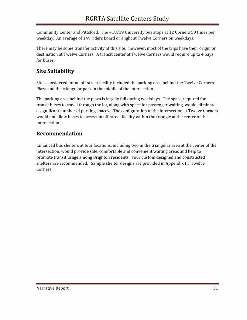
Transit Activity
Transit activity at this site is moderate, with two bus routes, the #7‐Monroe and the #18‐19 University, serving the site. The #7 Monroe bus provides access to downtown Rochester and the #18‐19 goes to Strong Hospital and the University of Rochester.
Five of the 83 scheduled trips on the #7‐Monroe either terminate or originate at Twelve Corners. The other stops at Twelve Corners are part of routes that continue on to the Jewish
RGRTA Satellite Centers Study
Narrative Report 31
Community Center and Pittsford. The #18/19 University bus stops at 12 Corners 50 times per weekday. An average of 149 riders board or alight at Twelve Corners on weekdays.
There may be some transfer activity at this site; however, most of the trips have their origin or destination at Twelve Corners. A transit center at Twelve Corners would require up to 4 bays for buses.
Site Suitability
Sites considered for an off‐street facility included the parking area behind the Twelve Corners Plaza and the triangular park in the middle of the intersection.
The parking area behind the plaza is largely full during weekdays. The space required for transit buses to travel through the lot, along with space for passenger waiting, would eliminate a significant number of parking spaces. The configuration of the intersection at Twelve Corners would not allow buses to access an off‐street facility within the triangle at the center of the intersection.
Recommendation
Enhanced bus shelters at four locations, including two in the triangular area at the center of the intersection, would provide safe, comfortable and convenient waiting areas and help to promote transit usage among Brighton residents. Four custom designed and constructed shelters are recommended. Sample shelter designs are provided in Appendix H: Twelve Corners.
RGRTA Satellite Centers Study
Narrative Report 32
CITYGATE The proposed CityGate mixed‐use development project is situated on the former Monroe County Iola Campus east of East Henrietta Road and south of Westfall Road. Approximately two‐thirds of the 47‐acre site is in the City of Rochester and one‐third is in the Town of Brighton. The project will incorporate approximately 400 residential units, 370,000 square feet of retail and commercial space, pedestrian recreation areas and a boat launch on the Erie Canal.
The project location is relatively well‐served by four existing Regional Transit Service (RTS) bus routes and a parking shuttle sponsored by the University of Rochester. Cumulatively, these routes operate 152 scheduled bus trips per weekday, 56 trips per Saturday and 40 trips per Sunday past CityGate property.
The site is currently used and will continue to be used by approximately 600 University of Rochester employees for parking and is served by the University of Rochester shuttle buses. The developers intend to create an urban neighborhood of mixed uses where transit is readily available to its residents and employees.
The site is served by the #5‐South Avenue bus, as well as the #91‐Avon/ Suburban Plaza, #12‐19th Ward/ MCC and #50‐MCC, and #24‐Marketplace Mall/RIT/ Scottsville. The #33/#34‐MCC route passes within one‐half mile of the site and could be extended to serve this development.
Limited transfers are expected, as most routes are through routes. Transit usage is anticipated to include CityGate residents and employees as well as University of Rochester employees who use the site for parking. The transit center would provide facilities for transit and/or shuttle service to the University of Rochester in conjunction with parking facilities.
The facility may be attached to a parking structure, or may be freestanding and located near a surface parking lot. Room for buses to pull off the road and pass other buses will be required.
Off‐street transit facility is envisioned at this site, located at ground level within a parking structure. Amenities may be incorporated into the facility. However, commercial development will need to be compatible with the services to be established in the neighboring development. The design of the transit center is being prepared by the CityGate development team.
RGRTA Satellite Centers Study
Narrative Report 33
COST ESTIMATES The estimate of costs to develop a transit center includes the following components:
• Acquisition of land
• Demolition of existing buildings/ Site preparation
• Site Development
• Building Construction
• Design/ Engineering/ Construction Management/ Legal
Cost estimates were prepared for the Mt. Hope Station and West Main Street transit centers.
Mt. Hope Station Site
Cost estimates were prepared for the three alternative sites that were identified for the Mt. Hope Station transit center:
• Preferred Site: Strong property west of Mt. Hope Avenue (integrated with the University of Rochester’s proposed “Collegetown” development)
• Alternative A: Commercial area along east side of Mt. Hope Avenue
• Alternative B: Residential/ Commercial properties along south side of Crittenden Blvd.
Acquisition of Land
Preferred site
Acquisition of land would be negotiated with the University of Rochester as part of a Joint Development agreement.
To be negotiated as part of Joint Development agreement
Alternative A
The site consists of four commercial properties located along the east side of Mt. Hope Avenue. The corner property (1432 Mt. Hope) is currently a McDonald’s restaurant; to the south is the former Record Archive store (1394 Mt. Hope Ave.); the two properties south of these (1378 and 1380 Mt. Hope Avenue) include a Starbucks and a Subway franchise.
The total assessed value of these four properties is $1,105,300. However, the assessed value does not take into consideration the value of the business at this location. The McDonald’s

RGRTA Satellite Centers Study
Narrative Report 34
restaurant in particular is very busy. Acquisition costs are expected to be in excess of $1 million for this property alone.
Estimated at $2.2 million
Alternative B
The site consists of 18 residential properties, including one 2‐family dwelling and one 3‐family dwelling, as well as four parcels that comprise the HSBC Branch Bank and parking lot at 1477 Mt. Hope Avenue. The average assessed value of the single family residential parcels is $86,000. An appraisal of nearby residential dwellings estimated that the actual value is an average of 35% higher than the assessed value. Based on this assumption, the cost to acquire the residential parcels is estimated at $450,000.
The four bank parcels are assessed at $620,200. However, this value does not take into consideration the value of the business. Unless HSBC has plans to close this branch (and there is no indication that this is being contemplated), acquisition cost is likely to be more than $1 million.
Estimated at $1.5 million
Demolition/ Site Preparation
Demolition costs are expected to include the removal of existing buildings, filling in of basements, abatement of any asbestos that may be found on the site, severing of utility services, and asphalt removal.
Preferred Site Demolition is expected to be carried out as part of the overall redevelopment of the site. Alternative A The cost to raze the four commercial structures is estimated at $60,000/ building, or $240,000. An additional $40,000 is expected to be required to remove the asphalt from the existing parking lots.
Estimated at $280,000
RGRTA Satellite Centers Study
Narrative Report 35
Alternative B The cost to raze 18 residential structures is estimated at $40,000/ building, or $720,000. An additional $72,000 would be required to remove asphalt from driveways. The cost to raze the branch bank building is estimated at $40,000, with an additional $12,000 to remove asphalt from the parking areas.
Estimated at $844,000 Site Development Site development includes all of the development needed for the project construction except for the building. Components include driveways, drainage, lighting, curbing, benches, signage, fencing and landscaping. Where developed land is involved, curbs will need to be reconstructed. The estimated costs do not include off‐site improvements that may be required, such as the cost for rephrasing existing traffic signals or increasing the capacity of off‐site utilities. The design for Option C was used in determining the costs for site development. Alternatives A and B require higher costs for site development because of the need to accommodate on‐site parking as part of the design; the preferred site design assumed that the transit center would adjoin a parking structure. Preferred Site
Estimated at $1,200,000
Alternatives A & B
Estimated at $1,400,000
Building Construction
The cost to construct a 10,000 foot commercial structure is estimated at $200/ square foot, or $2 million. An additional $500,000 would be required to construct a structure that would provide shelter from the elements. This cost would include interior utilities such as water and sanitary sewer facilities, electricity, gas and telecommunications.
Preferred Site, Alternatives A & B
Estimated at $2,500,000
Design/ Engineering/ Construction Management/ Legal
Costs for engineering, design and architecture are estimated at 12% of the cost for site development and building construction. Costs for legal and administrative services are
RGRTA Satellite Centers Study
Narrative Report 36
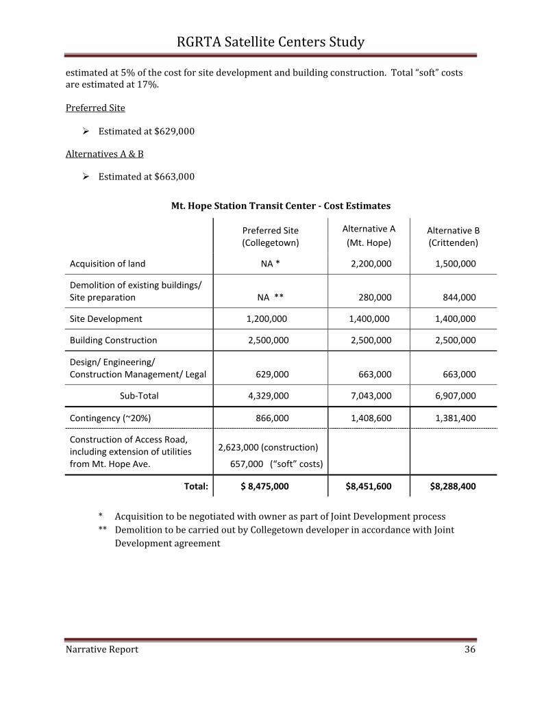
estimated at 5% of the cost for site development and building construction. Total “soft” costs are estimated at 17%. Preferred Site
Estimated at $629,000
Alternatives A & B
Estimated at $663,000
Mt. Hope Station Transit Center Cost Estimates
Preferred Site (Collegetown)
Alternative A (Mt. Hope)
Alternative B (Crittenden)
Acquisition of land NA * 2,200,000 1,500,000
Demolition of existing buildings/ Site preparation NA ** 280,000 844,000
Site Development 1,200,000 1,400,000 1,400,000
Building Construction 2,500,000 2,500,000 2,500,000
Design/ Engineering/ Construction Management/ Legal 629,000 663,000 663,000
Sub‐Total 4,329,000 7,043,000 6,907,000
Contingency (~20%) 866,000 1,408,600 1,381,400
Construction of Access Road, including extension of utilities from Mt. Hope Ave.
2,623,000 (construction)
657,000 (“soft” costs)
Total: $ 8,475,000 $8,451,600 $8,288,400
* Acquisition to be negotiated with owner as part of Joint Development process ** Demolition to be carried out by Collegetown developer in accordance with Joint
Development agreement
RGRTA Satellite Centers Study
Narrative Report 37
West Main Street Site
Cost estimates were prepared for Option E, which would require acquisition of the plaza.
Acquisition of Land
The property has been listed for sale at $6.7 million.
Estimated at $7 million.
Demolition/ Site Preparation
Demolition costs are expected to include the removal of existing buildings, filling in of basements, abatement of any asbestos that may be found on the site, severing of utility services, and asphalt removal.
The cost to raze the commercial structure is estimated at $200,000. An additional $40,000 is expected to be required to remove the asphalt from the existing parking lots.
Estimated at $240,000 Site Development Site development includes all of the development needed for the project construction except for the building. Components include driveways, drainage, lighting, curbing, benches, signage, fencing, landscaping and reconstruction of curbs. The estimated costs do not include off‐site improvements that may be required, such as the cost for rephrasing existing traffic signals or increasing the capacity of off‐site utilities.
Estimated at $1,400,000
Building Construction
The cost to construct a 10,000 foot commercial structure is estimated at $200/ square foot, or $2 million. An additional $500,000 would be required to construct a structure that would provide shelter from the elements. This cost would include interior utilities such as water and sanitary sewer facilities, electricity, gas and telecommunications.
Estimated at $2,500,000
Design/ Engineering/ Construction Management/ Legal
Costs for engineering, design and architecture are estimated at 12% of the cost for site development and building construction. Costs for legal and administrative services are
RGRTA Satellite Centers Study
Narrative Report 38
estimated at 5% of the cost for site development and building construction. Total “soft” costs are estimated at 17%.
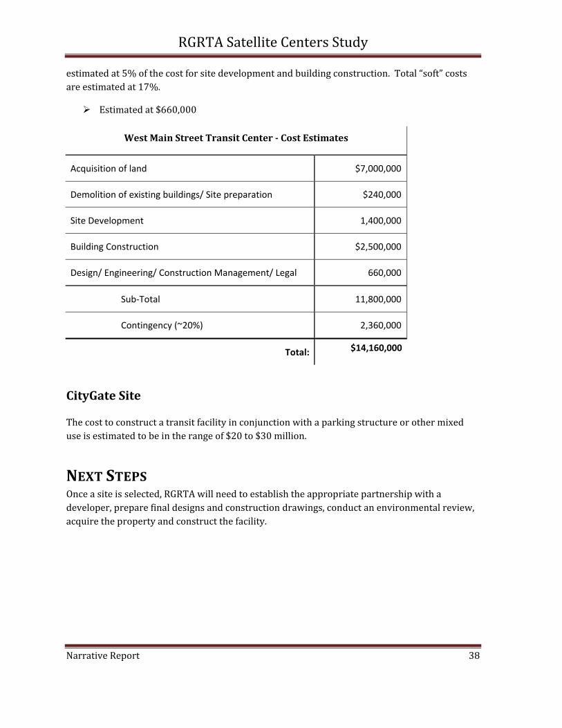
Estimated at $660,000
West Main Street Transit Center Cost Estimates
Acquisition of land $7,000,000
Demolition of existing buildings/ Site preparation $240,000
Site Development 1,400,000
Building Construction $2,500,000
Design/ Engineering/ Construction Management/ Legal 660,000
Sub‐Total 11,800,000
Contingency (~20%) 2,360,000
Total: $14,160,000
CityGate Site
The cost to construct a transit facility in conjunction with a parking structure or other mixed use is estimated to be in the range of $20 to $30 million.
NEXT STEPS Once a site is selected, RGRTA will need to establish the appropriate partnership with a developer, prepare final designs and construction drawings, conduct an environmental review, acquire the property and construct the facility.