Embed Size (px)
Citation preview
Report No. 175
Sediment Management Plan
Rhine
Summary
Imprint
Publisher:International Commission for the Protection of the Rhine (ICPR)Kaiserin-Augusta-Anlagen 15, D 56068 KoblenzP.O. box 20 02 53, D 56002 KoblenzTelephone +49-(0)261-94252-0, Fax +49-(0)261-94252-52Email: [email protected]
ISBN 978-3-941994-01-0© IKSR-CIPR-ICBR 2009
Bericht 175e 1
Bericht 175e
Internationale Kommission zum Schutz des Rheins Commission Internationale pour la Protection du Rhin
Internationale Commissie ter Bescherming van de Rijn
Sediment Management Plan Rhine
Summary
IKSR CIPR ICBR Sedimentmanagementplan
Sedimentmanagementplan.EN 2
SUMMARY
Sediment Management Plan Rhine 1 SUMMARY 2 1. Conceptual approach and state of knowledge 3
1.1 Problem analysis 3 1.2 Objective 3 1.3 Compilation of relevant sediment analyses 4 1.4 Assessment and classification of polluted sedimentation areas and major results 4 1.5 Data sheets on contaminated sedimentation areas (annex IV) 9
2. Proposals for measures 10 2.1 Measures reducing risks in polluted areas 10 2.2 Surveillance 12 2.3 Strategies to reduce sedimentation 12 2.4. Improvement of the overall data basis 13
Annexes Annex I: Map of areas posing a risk Annex II: Map of the “areas of concern” Annex III: Numbers of the sedimentation areas listed in the maps and of the
appropriate location names Annex IV: Data sheets of characteristics
IKSR CIPR ICBR Sedimentmanagementplan
Bericht 175e 3
1. Conceptual approach and state of knowledge
1.1 Problem analysis Human interference with the river bed and the alluvial areas (construction of impoundments and dikes) has sustainably changed fluvial sediment processes. During the past decennia, not only quantitative aspects of sediment processes have changed, but pollutants have also accumulated on sediments (a peak in sediment contamination was reached in the beginning of the 70s of the 20th century). Former very high direct pollutant inputs into waters and diffuse pollutant discharges from the watershed continue their negative impact on sediment quality. In particular, older polluted sediments in lower sediment layers in the Rhine and its tributaries can partly be remobilised by floods or be dredged and thus get into the flowing water and impact downstream river sections. Thus, there is a quantitative and a qualitative aspect to sediment management. Appropriate sediment management shall grant - Balanced sediment processes and - Sustainable good sediment quality, in order to achieve objectives of water and
soil protection and to enable the disposal of dredged material without causing harm (land deposit, deposit under water or re-deposition in the river).
Measures to achieve balanced sediment processes are indicated in chapter 2.3. Above all, the „Sediment Management Plan Rhine“ deals with qualitative sediment aspects. It proposes measures for sustainable, risk-oriented management of sediments and dredged material and for effective monitoring strategies for contaminated sediments as well as their potential of remobilization. If present discharges still contribute to contaminate sediments, measures may be required in the watershed. These will be the issue of programmes of measures according to the WFD and will eventually be discussed in this framework. Chapter 2 summarizes the proposals for measures submitted in the Sediment Management Plan.
1.2 Objective The 71st Plenary Assembly staged in Bregenz on 8 July 2005 asked the ICPR expert group "Sediment management" (Sedi) to draft a holistic sediment management strategy for the Rhine. The mandate includes the drafting of a management plan for contaminated sediments with - An inventory of available information for relevant amounts and relevant
sediment contaminations in the Rhine watershed - An assessment and classification of contaminated sediments and - Drafting proposals for measures concerning the treatment of contaminated
sediments. The result will be a survey of “hot spots” (in the following called ‘areas posing a risk') including proposals for measures and priorities for eventual remedial measures. The priority aim is to localize those sediment areas which pose the greatest risk for achieving good water quality. For these areas posing a risk of great importance for the Rhine, proposals for measures will be presented which are meant to serve as recommendations for actions for the authorities in charge of the further treatment of the sediments in these river sections.
IKSR CIPR ICBR Sedimentmanagementplan
Bericht 175e 4
Furthermore, a general basis of assessment is to be given for the assessment of further sedimentation areas which have so far not been systematically examined and which may eventually serve as starting point for restoration measures. This procedure also underpins the implementation of article 3, point 3 of the Rhine Convention with respect to the “improvement of sediment quality in order to dispose of dredged material without causing any harm”. Additionally, the legal framework is given by decisions taken by the OSPAR Commission for the Northeast Atlantic, the German-French Commission on the Training of the Upper Rhine and the Water Framework Directive (WFD) of the EU.
1.3 Compilation of relevant sediment analyses The relevant sediment analyses have been compiled on the basis of existing analysis results. All in all, more than 90 locations along the Rhine and in sections near the outlets of Rhine tributaries (e.g. rivers Neckar, Main, Ruhr) were inventoried, including sections of the High Rhine located along the German-Swiss border. In the lower section of the R. Moselle, sedimentations are only of the grit or gravel kind; therefore, this section has not been included into the inventory (literature see the final report in annex 6 – section topics). Largely, analysis results date back to the last ten years up to 2006. The results of the ICPR research project „Investigations on the risk of re-suspending sediments in selected barrages of the Rhine area“ from the years 2000-2002 were of particular importance, as profiles up to about 1 m depth had been taken and analysed per section. These investigations were carried through along the French and German Upper Rhine. Two further investigation areas were located in the Netherlands. For the other points in the German river section (e.g. ports) we dispose of results from random samples taken from the sediment surface. These are analysis results of the authorities of the German Länder and of the German Institute for Hydrology (Bundesanstalt für Gewässerkunde – BfG) disposing of results for several years. The data basis for the Dutch section comprises results from restoration programmes for the river bed of state waters carried through under the law on soil protection. At these locations, the sampling frequency varies from individual to hundreds of samples taken during one or several years. Chapter 2.4 comprises information on how to improve the data basis.
1.4 Assessment and classification of polluted sedimentation areas and major results The basic conceptual approach is based on the recommendations of the European Sediment Network SedNet and two studies on sediment contamination of the rivers Rhine and Elbe and has been further developed. The following steps were taken within a comprehensive process: - At first, the pollutants relevant for the watershed were established and the areas
contaminated by these pollutants were identified. - In a second step, the amounts of contaminated sediments in the areas of
investigation were determined. - In a third step it is being investigated, in how far a re-mobilisation of
contaminated sediments is liable to detrimentally impact the waters or their good status further downstream. For these investigations, the assessment of the risk of re-mobilisation due to floods, wind, and anthropogenic impacts (dredging, re-deposition, navigation) plays an important role.
IKSR CIPR ICBR Sedimentmanagementplan
Bericht 175e 5
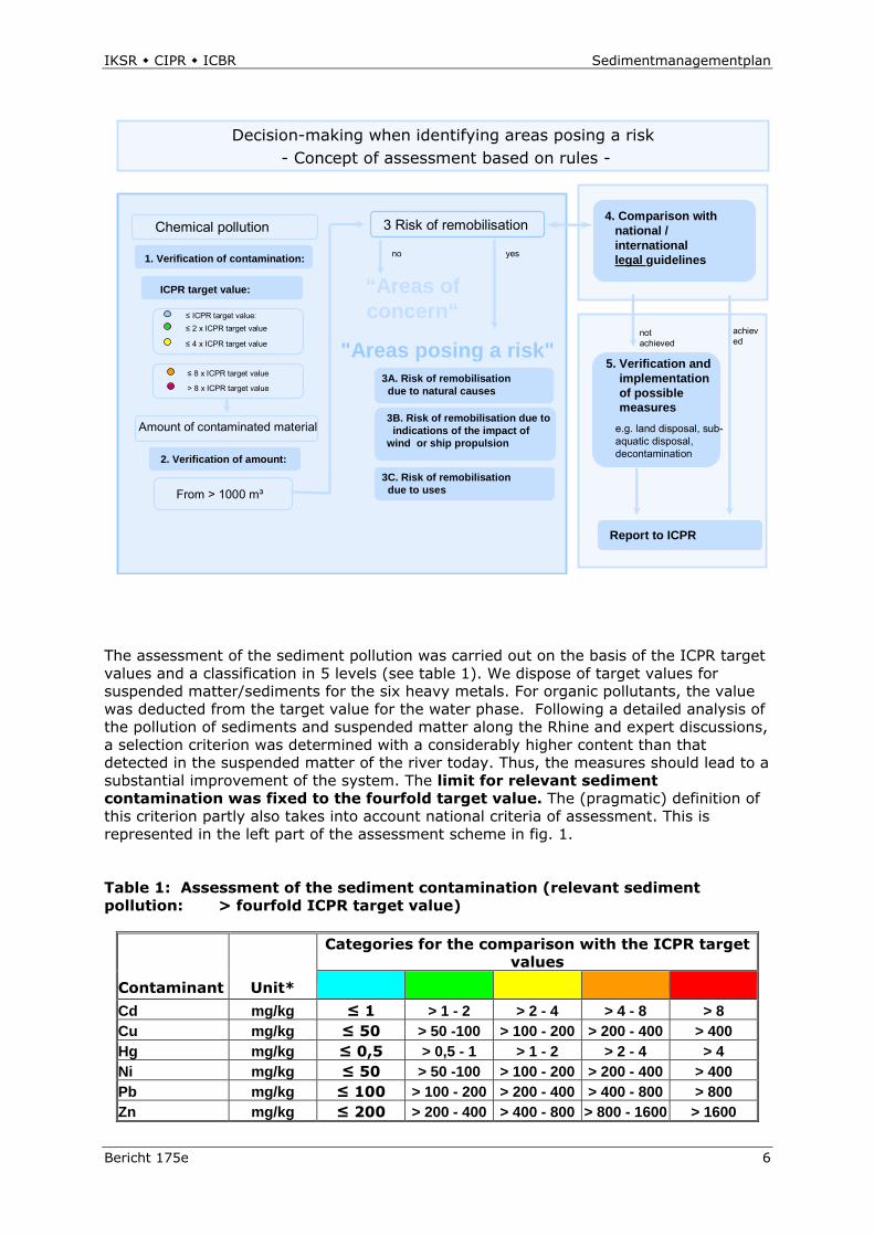
In the following, approach and rules of assessment and classification of sediments are described. This description may lead to the identification of areas posing a risk. The most important elements of the approach are the assessment of the chemical pollution based on the ICPR target values and the assessment of the risk of re-mobilisation of great contaminated sediment areas, taking into account national/international regulations. The scheme of assessment (fig. 1) summarizes the rules.
1.4.1 Assessment of the chemical pollution with pollutants relevant for the Rhine Today, the following priority substances of the ICPR action programme Rhine 2000 are relevant for adsorption and accumulation in suspended matter/sediments: The heavy metals lead (Pb), cadmium (Cd), copper (Cu) nickel (Ni), mercury (Hg) and zinc (Zn) as well as the organic micro-pollutants hexachlorobenzene (HCB) and Benzo (a) pyren (representing the polycyclic aromatic hydrocarbons (PAH)). In addition, the polychlorinated biphenyls (PCB) PCB 153 and the sum of PCB (7 indicator PCB) representing this group of substances must be mentioned. Fig. 1: Scheme of assessment
IKSR CIPR ICBR Sedimentmanagementplan
Bericht 175e 6
Chemical pollution
Amount of contaminated material
3 Risk of remobilisation
2. Verification of amount:
3A. Risk of remobilisationdue to natural causes
Decision-making when identifying areas posing a risk- Concept of assessment based on rules -
1. Verification of contamination:
4. Comparison with national / international legal guidelines
ICPR target value:
≤ ICPR target value:≤ 2 x ICPR target value
≤ 4 x ICPR target value
From > 1000 m³
3B. Risk of remobilisation due toindications of the impact of
wind or ship propulsion
achieved
“Areas of concern“
"Areas posing a risk"5. Verification and
implementationof possiblemeasures
e.g. land disposal, sub-aquatic disposal, decontamination
Report to ICPR
achieved
not achieved
3C. Risk of remobilisation due to uses
no yes
≤ 8 x ICPR target value
> 8 x ICPR target value
The assessment of the sediment pollution was carried out on the basis of the ICPR target values and a classification in 5 levels (see table 1). We dispose of target values for suspended matter/sediments for the six heavy metals. For organic pollutants, the value was deducted from the target value for the water phase. Following a detailed analysis of the pollution of sediments and suspended matter along the Rhine and expert discussions, a selection criterion was determined with a considerably higher content than that detected in the suspended matter of the river today. Thus, the measures should lead to a substantial improvement of the system. The limit for relevant sediment contamination was fixed to the fourfold target value. The (pragmatic) definition of this criterion partly also takes into account national criteria of assessment. This is represented in the left part of the assessment scheme in fig. 1. Table 1: Assessment of the sediment contamination (relevant sediment pollution: > fourfold ICPR target value)
Categories for the comparison with the ICPR target values
Contaminant Unit* Cd mg/kg ≤ 1 > 1 - 2 > 2 - 4 > 4 - 8 > 8 Cu mg/kg ≤ 50 > 50 -100 > 100 - 200 > 200 - 400 > 400 Hg mg/kg ≤ 0,5 > 0,5 - 1 > 1 - 2 > 2 - 4 > 4 Ni mg/kg ≤ 50 > 50 -100 > 100 - 200 > 200 - 400 > 400 Pb mg/kg ≤ 100 > 100 - 200 > 200 - 400 > 400 - 800 > 800 Zn mg/kg ≤ 200 > 200 - 400 > 400 - 800 > 800 - 1600 > 1600

IKSR CIPR ICBR Sedimentmanagementplan
Bericht 175e 7
Benzo(a) pyren mg/kg ≤ 0,4 > 0,4 - 0,8 > 0,8 - 1,6 > 1,6 - 3,2 > 3,2 HCB µg/kg ≤ 40 > 40 - 80 > 80 - 160 >160 - 320 > 320 PCB 153 µg/kg ≤ 4 > 4 - 8 > 8 - 16 >16 - 32 > 32 PCB (Sum 7) µg/kg ≤ 28 > 28 - 56 > 56 - 112 > 112 - 224 > 224
* All indications refer to dry substance
1.4.2 Assessment of the quantitative pollution of contaminated sediments and of the risk of re-mobilisation a) Classification as “area of concern” If relevant sediment contamination according to chapter 1.4.1 is assessed and the amounts of contaminated sediments are in excess of 1000 m³, the sedimentation areas requires particular attention. These sedimentation areas are called „areas of concern“, if there is no natural or man-made risk of re-mobilisation. In general, these areas do not represent any risk for downstream river sections. Nonetheless, attention must be paid to these sediments and during periodic maintenance dredging or individual construction measures they should be treated in accordance with the rules for national re-deposition of dredged material or they should be subject to controlled disposal. As far as German ports are concerned, „areas of concern“ are found, when values are also in excess of the national criteria for the re-deposition of dredged material into the flowing water. In these cases it will be made sure that sediments are duly treated or stored. On the basis of the data present and the rules of assessment, 9 „areas of concern“ have been identified in the Dutch Rhine area and further 9 areas were identified in the German section (ports). Annex II includes a map of the Rhine watershed with the identified „areas of concern“. b) Classification as area posing a risk Further areas of sedimentation will be assessed, where values are equally in excess of those applicable to the criteria of contamination and sediment amounts but where, in addition, sediments may be re-mobilised. They will be subject to differentiated analysis depending on the risk of re-mobilisation and thus the probability that they will impact the good water status of downstream areas. The approach for assessing the risks of re-mobilisation is as follows: If polluted amounts of sediment according to a) are assessed, and there is a real risk of re-mobilisation due to natural (e.g. floods) or man-made impact (e.g. dredging in connection with re-deposition), the area of sedimentation is classified as area posing a risk. All depending on the kind of re-mobilisation the areas thus identified are classified at level A, B and C. The assessment of the total transported amount of pollutants at a given time is necessary in order to be able to deduce the order of magnitude of re-mobilisation and the importance of the resulting contamination of the watershed due to the pollutant concentration in sediments. The classification of the risk of re-mobilisation during flood events (type A) applies different methods:
IKSR CIPR ICBR Sedimentmanagementplan
Bericht 175e 8
On the one hand, adequate flood analysis covering several sections of the Rhine may be carried out in order to come to statements on the origin of the risk of re-mobilisation based on the estimate of the pollutant load. On the other hand, (costly) investigations on the stability of the position of sediments may be carried through. The relevant parameter to be considered depending on the depth is the critical shear stress τkrit at the river bottom. A comparison of τkrit with the shear stress caused by floods with 10 years return period permits to assess the risk of remobilisation due to floods. Apart from floods, greater amounts of contaminated sediments may also be remobilised due to the impact of wind or ship propulsion (type B). This case applies to the Dutch section of the Rhine and is proven by expert judgement. The risk of remobilisation due to maintenance dredging (type C) is given when it proves that national criteria (as an example: Handlungsanweisung für den Umgang mit Baggergut im Binnenland (HABAB) der Wasser- und Schifffahrts-Verwaltung des Bundes (WSV)) are respected. In these cases, according to national criteria, a re-deposition in the flowing water would be possible.
1.4.3 Results of the risk assessment The classification of contaminated sediment areas as areas posing a risk differentiates between three kinds of risks of remobilisation (see figure 1): Type A: Risk of remobilisation due to natural causes (floods) Type B: Risk of remobilisation due to the impact of wind or ship propulsion Type C: Risk of remobilisation due to maintenance dredging in order to grant
navigation, in particular in harbours. From type A to type C, the risk of remobilisation becomes more controllable. Type A - Areas: If the three criteria: considerable contamination (e.g. due to HCB) and great amounts of sediments liable to remobilisation coincide, the area posing a risk is classified as type A. These areas pose a severe risk of transporting pollutants to downstream unpolluted areas. Therefore, as a matter of principle, type A areas posing a risk must be examined with respect to rehabilitation measures (chapter 2). On the basis of present data and the agreed approach to assessment, 16 type A areas posing a risk were identified in the Rhine area. These are areas of sedimentation 1. In the backwaters of the impoundments at Marckolsheim, Rhinau, Strasbourg, 2. In the backwaters of the impoundments Eddersheim on the Main and Ruhr near
Duisburg 3. 11 further sedimentation areas located in the Dutch section of the Rhine. As shown by the results of the already mentioned ICPR research project, the sediments in the impoundments mentioned and located in the Rhine tributaries Main and Ruhr are partly consolidated and thus present a considerably less risk of remobilisation than the sediments in the impoundments on the Upper Rhine (see also proposals for measures in chapter 2.1.1). In the barrages Marckholshiem, Rhinau and Strasbourg, where distinct sections have already been pointed out as type A areas, little contaminated sediments are dredged with a view to adapting the flow regime or to maintaining the flow regime of navigation lanes.
IKSR CIPR ICBR Sedimentmanagementplan
Bericht 175e 9
Particular care must be paid during dredging in order to avoid the risk of remobilising heavily contaminated sediments in adjacent sedimentation areas. Type B - Areas: Contaminated sediments above 1000 m³ with little natural risk of remobilisation but presenting a risk of remobilisation due to the impact of wind and ship propulsion. In the Dutch section of the Rhine, 2 type B areas posing a risk have been identified: Rietbaan (Noord) and Ketelmeer-West. Type C - Areas: Polluted sediments above 1000 m³ not presenting any natural risk of remobilisation but which may be concerned by dredging measures and be transferred into the flowing water, as the corresponding national criteria for re-deposition within the water body are respected, are, as a matter of principle, identified as type C areas posing a risk. This means that the risk due to re-deposition is only given due to uses. In the German section of the Rhine, analysis results of 39 ports were included in the assessment. However, in 4 cases, in which, according to table 1, relevant sediment pollution is detected, national criteria (WSV-HABAB) permit re-deposition. The ports concerned are Ehrenbreitstein, Brohl, Mondorf and the entrance to the port of Neuss. Compared to the type A areas, the risk of pollution is less, as there is no natural potential for remobilisation and the amounts of polluted sediments are considerably less (typically, amounts between 1000 m³ and 5000 m³ must be dredged in order to restore the set depth in ports). The fact files (data sheets of characteristics, chapter 1.5) on the different areas posing a risk present the risk of remobilisation posed by dredging. All in all, national regulations must help to avoid a transportation of pollutants from these areas at risk to downstream sections of the Rhine. A map of the Rhine watershed and its identified type A, B and C areas posing a risk is enclosed in annex I. The assignment of numbers to the areas refers to the numbers of the data sheets for the different sedimentation areas. The corresponding list of numbers and the equivalent names of the locations of the sediment areas are enclosed in annex III.
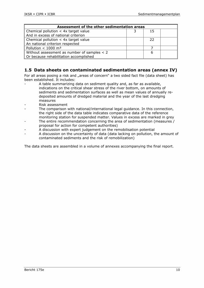
1.4.4 Further assessment results In 18 sedimentation areas with amounts of more than 1000 m³ values are not in excess of the internationally determined criteria for chemical pollution. However, the preliminary assessment shows that the national criteria are being exceeded. For information, the tables of results for these 18 areas are given in annex 10 of the final report. Analysis data of further 22 sedimentation areas were available. However, pollutant concentrations were so low that none of the assessment criteria were exceeded. Data for these areas are represented in annex 11 of the final report. Table 2 gives a survey of the assessment result for all 93 sedimentation areas. Table 2: Assessment result for all 93 sedimentation areas D/F D NL
Areas posing a risk Type A 3 2 11 Type B 2 Type C 4
Areas of concern 9 9
IKSR CIPR ICBR Sedimentmanagementplan
Bericht 175e 10
Assessment of the other sedimentation areas Chemical pollution < 4x target value And in excess of national criterion
3 15
Chemical pollution < 4x target value An national criterion respected
22
Pollution < 1000 m³ 7 Without assessment as number of samples < 2 Or because rehabilitation accomplished
6
1.5 Data sheets on contaminated sedimentation areas (annex IV) For all areas posing a risk and „areas of concern“ a two sided fact file (data sheet) has been established. It includes: - A table summarizing data on sediment quality and, as far as available,
indications on the critical shear stress of the river bottom, on amounts of sediments and sedimentation surfaces as well as mean values of annually re-deposited amounts of dredged material and the year of the last dredging measures
- Risk assessment - The comparison with national/international legal guidance. In this connection,
the right side of the data table indicates comparative data of the reference monitoring station for suspended matter. Values in excess are marked in grey
- The entire recommendation concerning the area of sedimentation (measures / proposal for action for competent authorities)
- A discussion with expert judgement on the remobilisation potential - A discussion on the uncertainty of data (data lacking on pollution, the amount of
contaminated sediments and the risk of remobilization) The data sheets are assembled in a volume of annexes accompanying the final report.
IKSR CIPR ICBR Sedimentmanagementplan
Bericht 175e 11
2. Proposals for measures
Proposals for measures are addressed to the authorities in charge, in this case the managers of the shipping lanes, of impoundments and the authorities in charge of water management of the Länder concerned. They are to be taken into account during implementation. In all cases, the risk posed to downstream users must be examined. The proposed measures are based on the present state of knowledge. Before implementing the proposed measures, representative samples must be taken everywhere, in order to validate the data. Eventually, priorities for rehabilitation must be re-determined.
2.1 Measures reducing risks in polluted areas The data sheets present proposals for measures for the identified areas posing a risk which may lead to achieving the objective or for options for actions to be taken with priority:
2.1.1 Type A - Areas a) The three areas posing a risk in the backwater of the impoundments Marckolsheim, Rhinau and Strasbourg must be considered within the context of sediment contamination of the entire chain of the 10 impoundments. Therefore, the proposals for measures are considered against the background of the required maintenance dredging and the risk not to achieve the objectives set for the WFD for all impoundments on the Upper Rhine as a whole. The only pollutant responsible for the bad classification of the sediments of the Upper Rhine is HCB. HCB figures on the list of dangerous priority substances which, according to the WFD, are to be „phased out“. In individual cases, contents of PCB and mercury were slightly in excess in the sediments of the Upper Rhine, but the criteria for a classification as area posing a risk are not given. According to present knowledge, rehabilitation is proposed for the sedimentation areas in the impoundments at Marckolsheim and Rhinau, were considerably polluted and easily re-mobilised sediments are found. The assessment is based on the results of the ICPR research project (chapter 1.3 and final report annex 6, no. 5) and investigations of the Landesanstalt für Umwelt, Messungen und Naturschutz Baden-Württemberg. For the impoundment Strasbourg, no rehabilitation, but a verification of data is proposed, as high HCB pollutant contents were only found in the upper sediment layers which may easily be re-mobilised (see below). At Marckolsheim and Rhinau, rehabilitation measures are required in order to interrupt the permanent discharge into the impoundments downstream. HCB attaches to suspended matter and is thus transported into the North Sea in average quantities of 10-20 kg per year. According to preliminary estimates, rehabilitation measures in both impoundments may however remove several 100 kg of HCB. On the long term, this will reduce the problems downstream. After rehabilitating the sources of pollution, a further distinct reduction of the sediment contamination of the impoundments downstream with HCB can be reckoned with. An accompanying monitoring programme will demonstrate the success of rehabilitation measures. In the two impoundments mentioned last, little polluted sediments are found around the weirs, which must regularly be removed during maintenance dredging. Present HCB concentrations of these sediments prove (average of 50 µg/kg at Marckolsheim) that the chemical criteria set out in the Sediment Management Plan as well as the (national) WSV-HABAB criteria are not achieved and that re-depositing sediments does thus not
IKSR CIPR ICBR Sedimentmanagementplan
Bericht 175e 12
pose any threat. Nevertheless, in order to further reduce the danger of re-depositing highly polluted sediments, it is proposed to take samples according to a fine network of locations in transition areas between areas with low sediment pollution to areas with high sediment pollution and dredging must be carried out with utmost care. Numerous investigations during the last years suggest that for many years the HCB pollution has spread from the original location of discharge near Rheinfelden to the chain of barrages in the Upper Rhine. Today, the situation is as follows: the pollution with HCB of the big impoundments Iffezheim and Gambsheim as well as of the impoundments Gerstheim and partly Strasbourg is comparatively low (average value 130 – 150 µg/kg HCB), but the ICPR criterion for the re-deposition of dredged material is still not respected. This recommendation requires unambiguous agreements when being connected to the target of decontamination. According to present knowledge, decontamination is not recommended for the sedimentation areas in the 4 barrages mentioned, but must concern the source of contamination. In order to keep the expenses for decontaminating the highly contaminated sediment areas of the impoundments at Marckolsheim and Rhinau as low as possible, a comparatively costly preliminary investigation must be carried out with professional bore machines (raster analysis) and core samples must be taken in order to delimit the highly contaminated sediment layers (horizons). According to initial estimates, about 160 000 to at maximum 260 000 m³ polluted sediments are to be expected in the Marckolsheim impoundment. One possibility of decontamination consists in a secure, sub-aquatic storage of the material in the coastal area (e.g. deposit “IJsseloog”). The expenses for the storage of dredged material including transportation expenses are estimated to 20 to 32 € net per m³ dredged material. Another alternative consists in partly securing sediments liable to be remobilised in a sub-aquatic environment. The prerequisite is that normal water discharge is preserved. Additionally, storage of the dredged material in the vicinity (islands, moles) as is the case in Iffezheim, will be examined. Expenses are estimated to some 8 € net per m³. Furthermore, it is proposed to examine the remobilisation potential of the HCB pollution in the Grand Canal d’Alsace, to assess it according to present criteria and to eventually carry out decontamination measures. Investigations show that significant HCB discharges originate from this area. b) The two identified areas posing a risk in the impoundments Eddersheim/Main and Duisburg/Ruhr are highly contaminated with heavy metals and PCB, but sediment volumes are less, compared to the areas mentioned under a) and c). Partly, sediments are consolidated to such an extent that small and medium floods will not remobilise them. In these areas, during extreme floods investigations should be carried out to find out whether and which amounts of polluted sediments are liable to be re-mobilised in the impoundment (balance sampling during a flood event). Furthermore, possibilities of capping polluted sediments should be investigated into and it should be examined, if a disposal is possible in connection with dredging for other reasons. c) The 11 areas at risk identified in the Dutch part of the Rhine watershed presenting high concentrations of PCB and of the heavy metals Cd and Hg have largely already been integrated into the implementation programme for the Dutch decontamination programme for the water bottom of state waters 2008 – 2013 and will be decontaminated during this period. The prevailing amount of contaminated sediments will be stored in sub-aquatic deposits.
IKSR CIPR ICBR Sedimentmanagementplan
Bericht 175e 13
2.1.2 Type B - Areas High PCB concentrations were found in the two areas posing a risk identified in the Dutch part of the Rhine watershed. Within this survey, the location Ketelmeer (West) with a contaminated sediment volume of 6 million m³ by far represents the largest area. Both locations have already been integrated into the Dutch decontamination programme. The eastern part of the Ketelmeer was already decontaminated some years ago.
2.1.3 Type C - Areas According to the present state of knowledge the sedimentation areas concerned are those of the four inland ports mentioned in chapter 1.4.3. For these contaminated sedimentation areas, the basic proposal is to improve the data basis by carrying through further investigations. First representative samplings of the surface and in depth lead to conclusions on the relevance of the contamination (see also chapter 2.4). Due to the much smaller amounts of contaminated sediments, a lesser natural risk of remobilisation and national regulations restricting the re-deposition, the risk is considerably easier to control than in type A areas.
2.2 Surveillance Basically and due to the data available, “areas of concern” require further observation. The following monitoring is recommended:
- Regular analysis of contaminated sediments including an assessment of the amount of sediments contaminated so far.
- Sampling during floods in order to make out, in how far there is a risk of remobilising contaminated sediments.
Further random sediment samples taken in other inland ports seem to indicate the presence of contaminated sediments, but volumes and the risk of remobilisation during floods are estimated to be of little relevance compared to the amounts of sediments found in impoundments. If at all, the risk will only be of local importance. In order to obtain further information regarding the eventual relevance for the Rhine, the data base will on the medium term be improved by further analysis.
2.3 Strategies to reduce sedimentation In order to reduce or avoid sedimentation in the impoundments and with a view to achieving balanced sediment processes it is proposed to combine construction measures in the river (e.g. construction of dividing breakwaters or baffles) and operative measures (optimize the control of weirs, techniques of re-deposition and of the dredging strategy). This combination offers the greatest potential to reduce sedimentation and to achieve a transportation of suspended matter with less barriers in a more nature-near state. However, first the required decontamination measures must be carried through in order to avoid contaminated sediments to be transported downstream even more rapidly than before.
IKSR CIPR ICBR Sedimentmanagementplan
Bericht 175e 14
2.4. Improvement of the overall data basis The present surveillance programme for surface waters also includes regular analysis of the contamination of suspended matter. However, this is not enough in order to estimate the risk posed by contaminated sediments. Where this has not already been implemented in the Rhine bordering countries it is proposed to intensify the analysis of suspended matter during flood events. This proposal also takes into account present considerations concerning increased occurrence and importance of floods due to climatic changes. Furthermore, at some locations sediments must regularly be analysed in order to improve the data basis and to obtain a comprehensive view of the quality of sediments liable to be remobilised (sediment register). Also, monitoring strategies adapted to the problem should be applied and, if required, samples should be taken from deeper sediment layers (0,5m to 1 m).
!(
!(!(!(!(!(!(!(
!(!(
!(
!(
!(
!(
!(
!(
!(
!(
!(!(
!(
!(
Sarre
Weser
Ems
Meuse
Rh
ein
Rhein
Donau
Inn
Main
Aller
Isar
Saale
Lippe
Neckar
Wer
ra
Aare
Sieg
Fulda
Mosel
Ruhr
Ohre
Lahn
Nahe
Marn
e
Saar
Ille
r
Naab
Aisne
Lech
Meu
se
Warn
ow
Mo
selle
Aare
Rh
in
Saone
Waal
LekIJ
sse
l
Essen/Duisburg
Hamburg
München
Brüssel Köln
Bremen
Hannover
Zürich
Stuttgart
Frankfurt/Main
Amsterdam
Magdeburg
Straßburg
Rotterdam
82
93
77
83
56
46
32
28
26
6
4
3
20
86
7576
89909192
8485
12°
11°
11°
10°
10°
9°
9°
8°
8°
7°
7°
6°
6°
5°
5°4°
53°
53
°
52°
52
°
51°
51
°
50°
50
°
49°
49
°
48°
48
°
47°
47
°
46°
46
°
±
Nordsee
Ostsee
0 8040 km
Realisierung - realisatie - réalisation
Koordinierung - coördinatie - coordination
NL
B
L
D
F
CHA
IT
D
Meurthe
1 - 93 Bezug zu Kennblättern Verwijzing naar de gegevensbladen Référence aux fiches signalétiques
!(
!(
!(!(!(
!(!( !(
!(!(
!(Rotterdam
77
86
75
76
8990
9192
84
85
82
Sedimentmanagementplan für den RheinSedimentmanagementplan voor de Rijn
Plan de gestion des sédiments pour le Rhin
Risikogebiet Typ ARisicogebied type AZone à risque de type A
Risikogebiet Typ CRisicogebied type CZone à risque de type C
Risikogebiet Typ BRisicogebied type BZone à risque de type B
!(
!(
!(
Risikogebiete mit Typisierungdes Remobilisierungsrisikos
Risicogebieden met specificatie van het risico op resuspensie
Zones à risque avec spécification du risque de remise en suspension

!(!(!(!(!(
!( !(!(!(
!(
!(
!(
!(
!(!(!(
!(
!(
Sarre
Weser
Ems
Meuse
Rh
ein
Rhein
Donau
Inn
Main
Aller
Isar
Saale
Lippe
Neckar
Wer
ra
Aare
Sieg
Fulda
Mosel
Ruhr
Ohre
Lahn
Nahe
Marn
e
Saar
Ille
r
Naab
Aisne
Lech
Meu
se
Warn
ow
Mo
selle
Aare
Rh
in
Saone
Waal
LekIJ
sse
l
Essen/Duisburg
Hamburg
München
Brüssel Köln
Bremen
Hannover
Zürich
Stuttgart
Frankfurt/Main
Amsterdam
Magdeburg
Straßburg
Rotterdam
80
72
88
60
5451
43
27
25
11
18
12
7973
8781
7478
12°
11°
11°
10°
10°
9°
9°
8°
8°
7°
7°
6°
6°
5°
5°4°
53°
53
°
52°
52
°
51°
51
°
50°
50
°
49°
49
°
48°
48
°
47°
47
°
46°
46
°
±
Nordsee
Ostsee
'Areas of Concern'
0 8040 km
Realisierung - realisatie - réalisation
Koordinierung - coördinatie - coordination
NL
B
L
D
F
CHA
IT
D
Meurthe
1 - 93 Bezug zu Kennblättern Verwijzing naar de gegevensbladen Référence aux fiches signalétiques
!(!(
!(!(
!(
!(
!(!(
Rotterdam
80
73
88
87
81
74
7978
Sedimentmanagementplan für den RheinSedimentmanagementplan voor de Rijn
Plan de gestion des sédiments pour le Rhin
!( 'Area of Concern'
IKSR CIPR ICBR Sedimentmanagementplan
Bericht 175e 17
Annnex III Table 3: Numbers of the sedimentation areas listed in the maps and of the
appropriate location names
Areas posing a risk (type A, B and C) "Areas of Concern"
No. Location No. Location
Type A 11 Spexer, new port 3 Marckolsheim 12 Speyer Floßhafen 4 Rhinau 18 Worms Bauhafen 6 Strasbourg 25 Port Lahnstein 20 Eddersheim/Main 27 Neuwied Pionierhafen 56 Duisburg/Ruhr 43 Port Hitdorf
51 Duisburg-Hüttenheim Hafen 75 Dordtsche Biesbosch, kleine kreken 54 Duisburg-Außenhafen 76 Dordtsche Biesbosch, grote kreken 60 Southern port Walsum 77 Hollandsch Diep 83 Amerongen 72 Afgedamde Maas 84 Gors Veerweg (Lek) 73 Nieuwe Merwede 85 Gors Drinkwaterinlaat (Lek) 74 Sliedrechtse Biesbosch 86 Gors Halfweg (Lek) 78 Wantij 89 Cluster Moordrecht-Gouderak 79 Beneden-Merwede 90 Cluster Nieuwerkerk-Ouderkerk 80 Oude Maas 91 Vaargeul + hotspots 81 Noord 92 Cluster Capelle-Krimpen 87 Vaargeul (Lek)
88 Zellingwijk (Hollandsche IJssel) Type B
82 Rietbaan (Noord) 93 Ketelmeer-West
Type C
26 Port Ehrenbreitstein 28 Port Brohl 32 Port Mondorf 46 Port entrance Neuss
IKSR CIPR ICBR Sedimentmanagementplan
Bericht 175e 18
Annex IV Data sheet of characteristics
This annex is only available in the German, Dutch and French language versions


![[DIP] Iron Rhine](https://img.pdfslide.tips/doc/110x75/577cc7581a28aba711a0a944/dip-iron-rhine.jpg)