Embed Size (px)
Citation preview
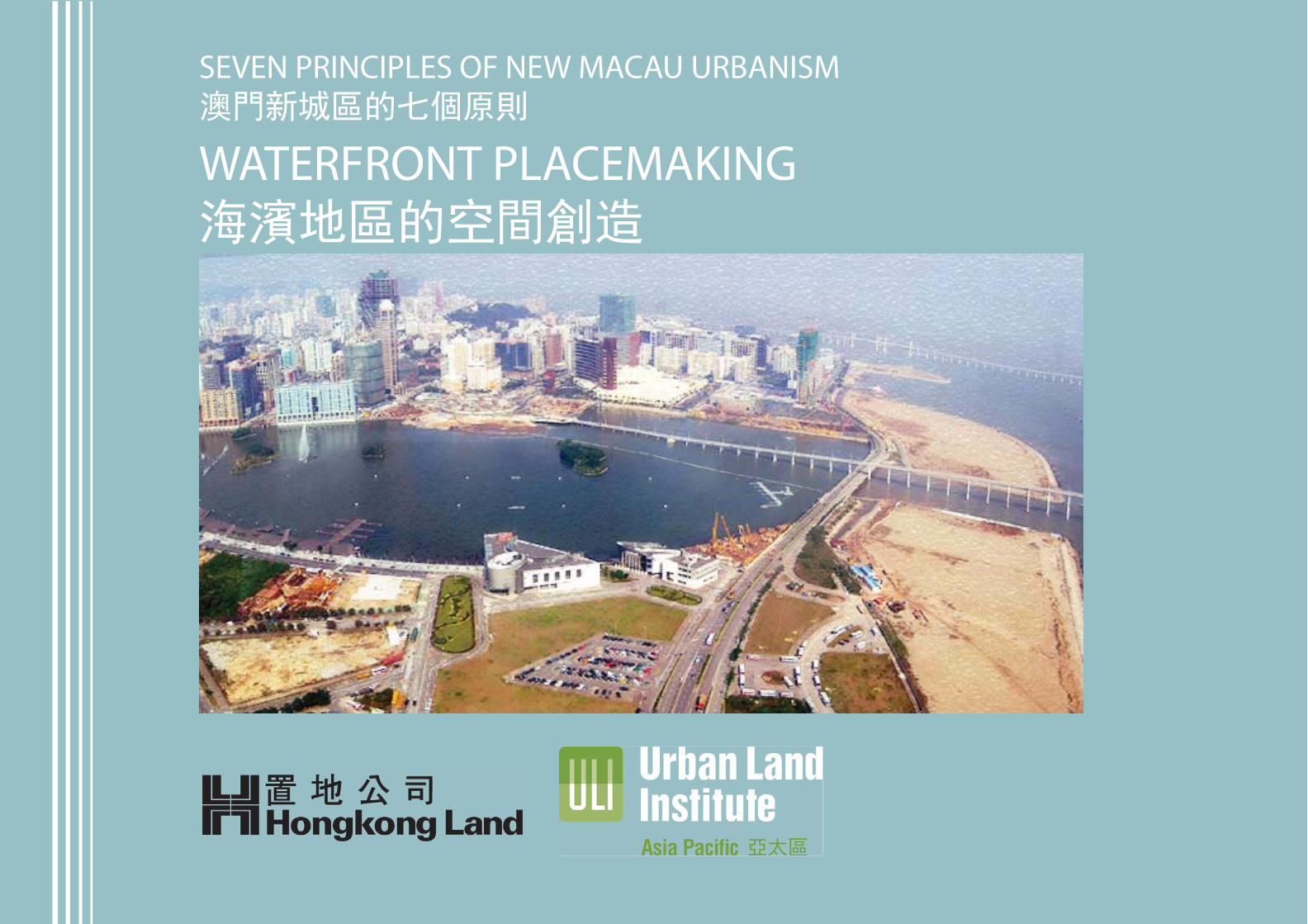
SEVEN PRINCIPLES OF NEW MACAU URBANISM澳門新城區的七個原則
WATERFRONT PLACEMAKING海濱地區的空間創造
MACAU MASTER PLAN ANALYSIS - ZONE B
INTRODUCTIONIs there another place such as Macau in this world?
Perhaps overlooked at times, it is an exotic, vibrant, fast growing city uniquely merging the confluence of preserved historical districts, surrounded by the South China Sea, the largest integrated resort gaming business in the world, and a wonderfully iconoclast place of Chinese and Portuguese residents, with an explo-sion of International visitors. While the recent gaming phenomena receives most of the news due to staggering annual growth, its abundant culinary cultural and pedestrian friendly adventures and relaxing pace of life, are equally draws for visitors growing at a 22% growth rate.
Macau, however, can strengthen key disjointed urban areas, and implement strategic planning to improve individual areas. Macau can significantly improve continuous links through important districts of the city often disconnected, which takes visitors and residents from natural pedestrian patterns, leaving them with a lack of taxis in the city, and sufficient means of mass transportation to move fluidly. With the planning of the Light Rail System, the activities in station neigh-bourhoods will grow, further improving with synergistic programming and the development of more abundant public space. This will create stronger proximity to the newly developing waterfront zones once more conscious planning takes place to stitch currently disparate parts, into a future whole.
At present however, the parts remain disconnected. The result is a lost opportunity to create a greater connective network bring far greater clarity to the way people experience Macau island, and a loss of physical brand and experience to generate the same all-day meandering which so enhances the pleasures of being in small historical towns in diverse places as Positano, Venice, Kyoto and Lijiang Old Town; places which allows people to immerse themselves completely in the human realm.
除了澳門,世上還有那一個像澳門這樣的地方?
澳門或許會偶然被忽略,但作為一個洋溢著異國情調,活力充沛,發展迅速的城市,澳門一直以其別具一格的方式延續著她的歷史文化。澳門三面環海,是世界最大的渡假博彩綜合產業之地,擁有風格獨立的中國與葡萄牙居民,及大量遊覽到訪的國際遊客。近年的博彩業以驚人的增長而廣為媒體報導,同時澳門的烹調美食文化,友善奇遇及當地閒適的生活節奏,對每年22%增長率的遊客同具吸引力。
然而,澳門必須強化城區之間脫節的狀況,並通過策略性規劃,增強貫通城區的通道,以改善現時的情況,令居民遊客可自由徒步,避免陷入既無計程車可乘亦無足夠集體運輸系統的困境。隨著輕軌系統的規劃,車站鄰近一帶的活動亦因應興旺,進一步增強協同規劃及發展更多公共空間。因此,新發展的海濱地區可以形成更緊密的毗鄰關係,與目前部分分散的地區透過規劃連綴成一整體。
由於目前澳門部份地區仍然未能全面連貫,所以沒有一個聯繫性強的網絡,使旅客對澳門的遊歷難有深刻印象,失去建立實質及經驗品牌的良機,未能如波西塔諾、威尼斯、京都和麗江古城的歷史名城那樣,給予遊客閑步和沉浸當中的完整體驗。
December 2011
2
MACAU MASTER PLAN ANALYSIS - ZONE B
While Senado Square occupies the traditional centre of town, the reclaimed waterfront promenade at the south edge of Macau island clearly will become the new signature and public face of Macau. A rich opportunity exists to provide a continuous link from the current ferry terminal, through Fishermen’s Wharf, the I.M. Pei designed Science Museum, the promenade by Lan Kwai Fong, and the government and cultural center newly proposed, finally terminating at the iconic Macau Tower. Metaphorically a circular walk through the city is actually possible to program, build and identify for future use.
While the intentions are correct, current planning shows aspects which can be significantly improved. We believe that the connectedness isn’t sufficiently strong. Between modifications to programming, reallocation of uses and building mass, integration of an improved extension of the urban grid to marry intuitively to the waterfront areas, and strongly extension of key viewing angles from key monu-ments on Penha Hill, a far stronger experience will result.
Rather than reiterate the content of the government planning proposal, we will point out the most important factors which enhance or inhibit the development of the new signature waterfront promenade and centre.
The main issues to overcome, are the heavy concentration of mid-rise government buildings identified in Zone B; the disconnection caused by this zoning to the larger promenade scenario previously described; the lack of integrated program-ming which can be used to create a more experiential overall atmosphere for this important new district, and the newly proposed road which cuts people off from the new green areas along the promenade.
Lessons learned of past modern cities indicate a counter-intuitive strategy moving roads from the waterfronts to improve traffic using secondary and organic flow of traffic, as well as the more important enhancement of human life and the vitality of waterfront urban areas that Boston and San Francisco, as two examples, have improved through integrating more fully, the extension of urban grids, and continuation of scale and smaller green streets and areas, to a contiguous water-front promenade all reachable by foot.
This waterfront area then would truly signify the new centre of the city, with iconic cultural and government buildings, with an inclusive, integrated playground area of green parks and performance areas that celebrates the major events of the calendar year.
In the following pages, concepts to improve the planning will be illustrated to convey the idea of the Seven Principles of Macau New Urbanism.
議事廳前地一直是澳門傳統的市中心地標,而在澳門南端經填海發展而成的海濱大道,亦將成為澳門的新地標及公共面貌。現在是一個很好的機會,締造一條連貫性的通道,起點由目前的港澳碼頭,經漁人碼頭,科學館,沿蘭桂坊大道,擬建的政府及文化中心,至地標性的澳門旅遊塔為止,設計及興建一條繞城的環迴步徑。
政府的規劃方向雖然正確,但個別環節尚有不少提升空間。我們相信,現時城區的連貫性仍未足夠。通過計畫修訂,從新分配用途及建築群體,整合經改良後的延展城市網絡,並與海濱大道相結合,大大加強主教山上紀念建築的觀景視角,將會給予人們一個更強烈的觀感經驗。
我們並不打算在這裏重複政府規劃建議的內容,而僅指出幾個最重要的觀點,希望可優化新城B區的發展。
較重要的課題包括:在新城B區的政府大樓群組;由於政府大樓群組而遭分割的海濱大道;位址欠缺全面的規劃;與及擬建的道路將公眾和海濱大道分割。
從過去的經驗,將道路移離海濱地帶,利用次級馬路及自然交通前往海濱,如波士頓與三藩市的實踐顯示,透過更充分的整合、延展城市網絡、連續較小的綠化街道,可打造一個完全由步行可達的、無間斷的海濱大道。
這樣的一個海濱大道,連同地標性的文化政府建築群,一個具包容性、整合性強的綠化公園及表演場地,能真正彰顯它作為整個城市中心的地位。
我們在下文會提出改進總體的概念,希望可闡釋澳門新城區的七個新發展原則。
December 2011
3
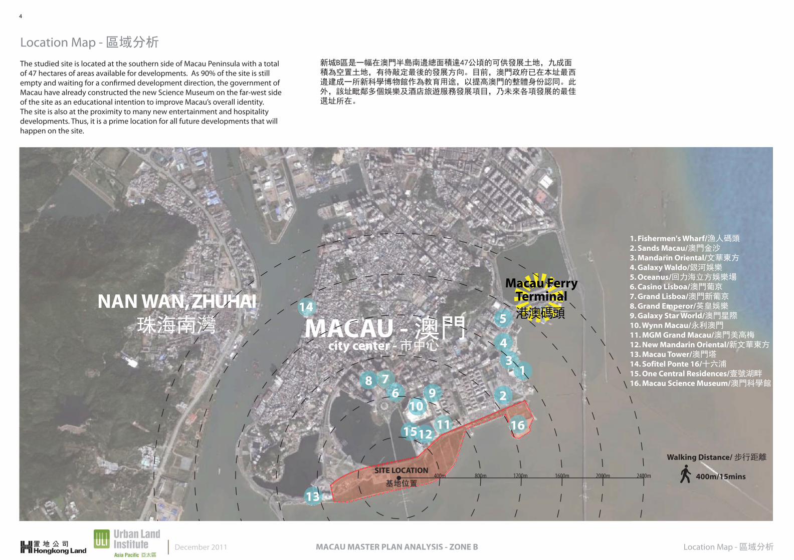
Location Map - 區域分析
Location Map - 區域分析MACAU MASTER PLAN ANALYSIS - ZONE BDecember 2011
1. Fishermen's Wharf/漁人碼頭2. Sands Macau/澳門金沙3. Mandarin Oriental/文華東方4. Galaxy Waldo/銀河娛樂5. Oceanus/回力海立方娛樂場6. Casino Lisboa/澳門葡京7. Grand Lisboa/澳門新葡京8. Grand Emperor/英皇娛樂9. Galaxy Star World/澳門星際10. Wynn Macau/永利澳門11. MGM Grand Macau/澳門美高梅12. New Mandarin Oriental/新文華東方13. Macau Tower/澳門塔14. Sofitel Ponte 16/十六浦15. One Central Residences/壹號湖畔16. Macau Science Museum/澳門科學館
NAN WAN, ZHUHAI 珠海南灣 MACAU - 澳門
city center - 市中心
Macau Ferry Terminal港澳碼頭
1
5
2
43
76
8
13
1112115
109
14
SITE LOCATION
基地位置
16
2400m2000m1600m1200m800m400m
Walking Distance/ 步行距離
400m/15mins
The studied site is located at the southern side of Macau Peninsula with a total of 47 hectares of areas available for developments. As 90% of the site is still empty and waiting for a confirmed development direction, the government of Macau have already constructed the new Science Museum on the far-west side of the site as an educational intention to improve Macau’s overall identity. The site is also at the proximity to many new entertainment and hospitality developments. Thus, it is a prime location for all future developments that will happen on the site.
新城B區是一幅在澳門半島南邊總面積達47公頃的可供發展土地,九成面積為空置土地,有待敲定最後的發展方向。目前,澳門政府已在本址最西邊建成一所新科學博物館作為教育用途,以提高澳門的整體身份認同。此外,該址毗鄰多個娛樂及酒店旅遊服務發展項目,乃未來各項發展的最佳選址所在。
4
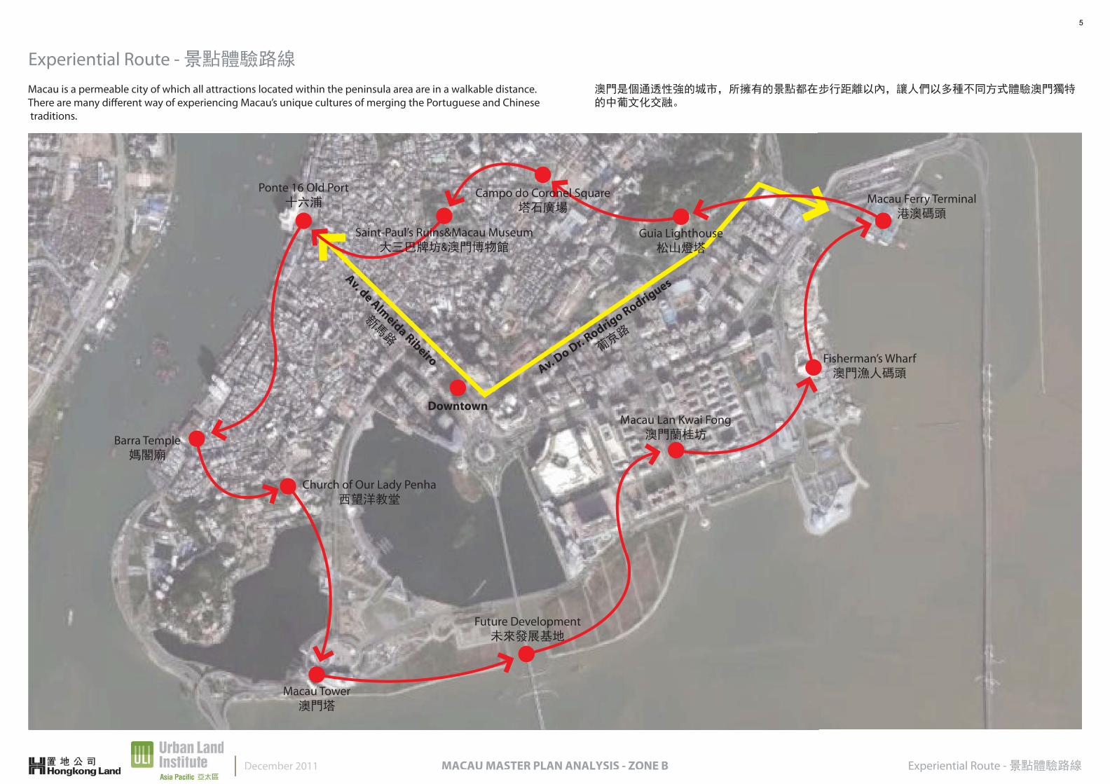
Experiential Route - 景點體驗路線
Experiential Route - 景點體驗路線MACAU MASTER PLAN ANALYSIS - ZONE B
Downtown
Av. Do Dr. R
odrigo Rodrigues
葡京路
Av. de Almeida Ribeiro
新馬路
Macau Ferry Terminal港澳碼頭
Guia Lighthouse松山燈塔
Campo do Coronel Square塔石廣場
Ponte 16 Old Port十六浦
Barra Temple媽閣廟
Church of Our Lady Penha西望洋教堂
Macau Tower澳門塔
Future Development未來發展基地
Macau Lan Kwai Fong澳門蘭桂坊
Fisherman’s Wharf澳門漁人碼頭
Saint-Paul’s Ruins&Macau Museum大三巴牌坊&澳門博物館
December 2011
Macau is a permeable city of which all attractions located within the peninsula area are in a walkable distance. There are many different way of experiencing Macau’s unique cultures of merging the Portuguese and Chinese traditions.
澳門是個通透性強的城市,所擁有的景點都在步行距離以內,讓人們以多種不同方式體驗澳門獨特的中葡文化交融。
5
Preserved Views - 山海景觀視廊December 2011
VIEWING TAIPA SKYLINE
N
0m 500m200m100m
VIEWS FROM PENHA HILL
AMARAL LARGO
PENHA HILL
MACAU MASTER PLAN ANALYSIS - ZONE B
Preserved Views Analysis - 山海景觀視廊
MARAL LA
ENHA HI
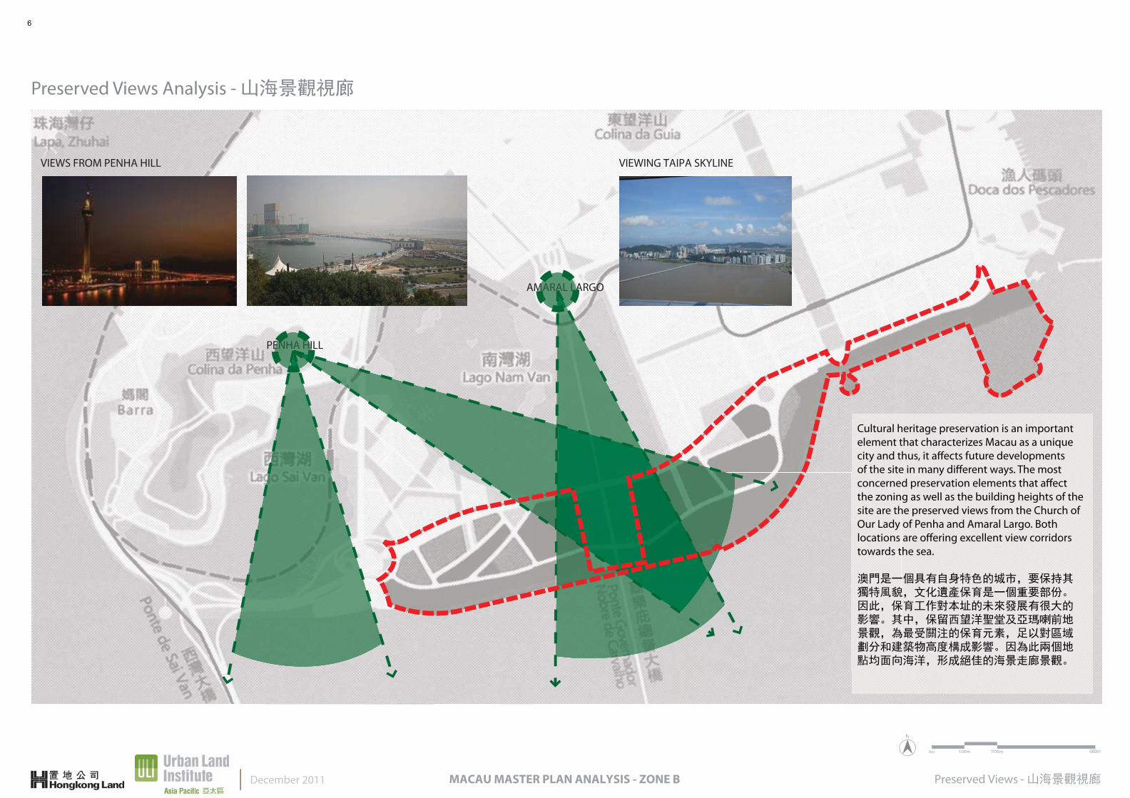
Cultural heritage preservation is an important element that characterizes Macau as a unique city and thus, it affects future developments of the site in many different ways. The most concerned preservation elements that affect the zoning as well as the building heights of the site are the preserved views from the Church of Our Lady of Penha and Amaral Largo. Both locations are offering excellent view corridors towards the sea.
澳門是一個具有自身特色的城市,要保持其獨特風貌,文化遺產保育是一個重要部份。因此,保育工作對本址的未來發展有很大的影響。其中,保留西望洋聖堂及亞瑪喇前地景觀,為最受關注的保育元素,足以對區域劃分和建築物高度構成影響。因為此兩個地點均面向海洋,形成絕佳的海景走廊景觀。
6

Proposed Zoning - 分區建議
N
0m 100m 200m 400m
Proposed Zoning - 分區建議MACAU MASTER PLAN ANALYSIS - ZONE B
Taking into consideration of the accessibility and connectivity of the city as well as to recreate a new skyline to the Macau peninsula, a mixture of different uses are proposed within the site will enable to activate the waterfront area as a new desitination. Interlocking the different uses that provides a thematic identitu to the new district/neighbourhood as well as a new festive gathering place.
考慮到澳門半島的便利性及連貫性,以及為這個城市塑造一個全新的天際面貌,建議將該址發展成多用途用地,活化海濱地段成為新的匯聚景點,透過環環相扣的不同土地用途,烘培出一個全新地區/社區主題,以提供一個節日假期的好去處。
December 2011
Mixed-use Development(High-Density)綜合體發展地(高密度)
Open Space開放空間
Commercial-use(Medium-Density)
商業用途(低密度)
Commercial-use(Low-Density)商業用途(低密度)
Cultural-use(Low-Density)文化用途(低密度)
Governmental Building Complex(Medium-Density)政府綜合大樓(中密度)
Science Museum(Low-Density)
科學館(低密度)
7

Planning Strategies: Preliminary Zoning Concept - 規劃分析:初步規劃概念
Planning Strategies: Preliminary Zoning Concept - 規劃分析:初步規劃概念MACAU MASTER PLAN ANALYSIS - ZONE BDecember 2011
1. Create a meandering main street to promote WALKABILITYA pedestrian-friendly street design encourages people to walk and experience the things in the surrounding space in a slower pace within a busy city. By locat-ing different services at proximity of 10 to 15 minutes walk allows pedestrian to meander in and out through a detailed designed space such as building are designed closer to streets allowing pedestrian interaction with architecture, tree-lined streets for shading as well as narrow street width to slow the speed of the users.
1. 創造一個主要大道,提供更佳的步行地區在一個繁忙的城市裡,一個以行人為本的街道設計能誘使人們樂意安步當車,將自己置身於區內環境之中,更好地體驗周圍事物。而將不同類型的服務置於10至15分鐘的步行距離內,令行人漫步在一個細緻設計的空間之中,迂迴出入,與設計上特意靠近街道的建築物產生親密的互動。植樹成線的街道除提供遮擋陽光的蔭涼空間外,更縮窄街道闊度,令行人放慢腳步節奏。
2. CONNECTIVITY of districts create pedestrian-friendly spacesA well designed street network, which includes a hierarchy of narrow street, roads, boulevards, and alleyways, will allow users to navigate with ease in an urban area. Interconnected street network will slowly lead the pedestrian to desire destinations where high quality designed pedestrian network should include landscaped public realms or public pockets.
2. 將不同地區連接起來,形成以行人為本的空間一個設計周詳的街道網絡,包括一個由窄街、道路、大道和小巷構成的通道序列,令行人輕易地在一個城市裡進進出出。相互貫通的街道網絡將行人不知不覺間帶到目的地。優質設計的行人網絡包括景觀點綴的公共領域或休憩空間。
3. MIXED-USE and DENSITYImplementing a mix of uses such as shops, offices and apartments within a building and city block as well as the neighbourhood will promote diversity and community cohesion. Mixed-use and density helps to generate activities on a 24-hour basis and maximize the value of the area.
4. Promote diversity in PUBLIC SPACESDiverse social interaction is one of the main goals of promoting placemaking; thus, creating a safe space where people can celebrate and seek out their cultural peers is important for designing a desire world-class project. Program public spaces with educational and cultural activities will not only promote be a celebration for diverse cultural events, but also will assure that the public spaces planned will be use throughout the year.
5. Quality ARCHITECTURE and URBAN DESIGNWith emphasis on beauty, aesthetics, and human comfort will help in creating a sense of place for the local residents as well as the tourists. Special placement of civic uses and sized would guide people to its desire destinations and also will give a sense of direction when meandering within the city realm. Iconic civic buildings should not only be an aesthetic element, but should also serve as a community gathering space. Therefore, architecture and public spaces should be to human-scale and well-landscaped.
6. SMART TRANSPORTATIONThe main goal of implementing smart transportation is to create transportation facilities that are safe and affordable, responsive to the needs of all users, and support community planning goals. Thus, implementing a high-quality train network connecting the districts and neighbourhoods promotes smart transpor-tation. Furthermore, pedestrian-friendly design encourages a greater use of bicycles and walking as daily transportation.
7. SUSTAINABILITYSustainability should be taken into consideration in planning. Minimal environ-ment impact of the development, eco-friendly technologies, respect for ecology and value of natural systems, energy efficiency are all key items to be considered in the master planning stage while strict guidelines should be implemented at the same time.
3. 多用途與密度性將商舖、辦公室及住宅置於同一所建築物內、同一個地段內,或社區內,皆可增強社區的多元性和凝聚力。多用途與密度性可帶動24小時的活動,以發揮地區的最大價值。
4. 增強公共空間的多元性空間創造的其中一個主要目的是造就多元化的社會互動,因此,創建一個安全的空間,讓人們樂在其中尋找他們的文化同輩,對一個世界級設計項目來說,顯得非常重要。以教育及文化活動建設公共空間,並不止於宣傳多元文化活動,更必要的是要肯定公共空間會被利用。
5. 優質建築與城市設計注重美觀、審美和人體舒適感令本地居民及遊客均感到地區歸屬感。精心安排的公眾設施位置,把人們引領往心目中的地點,同時為遊人迂迴漫步城區時提供方向感。具有標誌性的公民大樓不只有美感,同時能成為社區聚會點。因此,建築設計及公共空間應合乎人與物的比例及全面的景觀資源。
6. 智能交通運輸智能交通運輸系統的主要目的是建立一套安全、可負擔的運輸設施,能滿足各使用者的需要並支援社區規劃的目標。因此,高效優質的鐵路網絡將社區與鄰近地方連成一體,直接助長智能交通運輸的發展。此外,以行人為本的設計亦吸引人們於日常更多使用單車或步行。
7. 可持續性可持續性在規劃階段便應被納入考慮之列。盡量減低發展對環境的衝擊,引用環保型技術,對生態與大自然系統的價值懷有敬愛之心,及節約能源,這些都是總體規劃階段所必須納入的關鍵元素,與之同時,亦不應忘記制定嚴格的指引。
8
Physical Organization Programming - 指標說明
Physical Organization Programming - 指標說明MACAU MASTER PLAN ANALYSIS - ZONE B
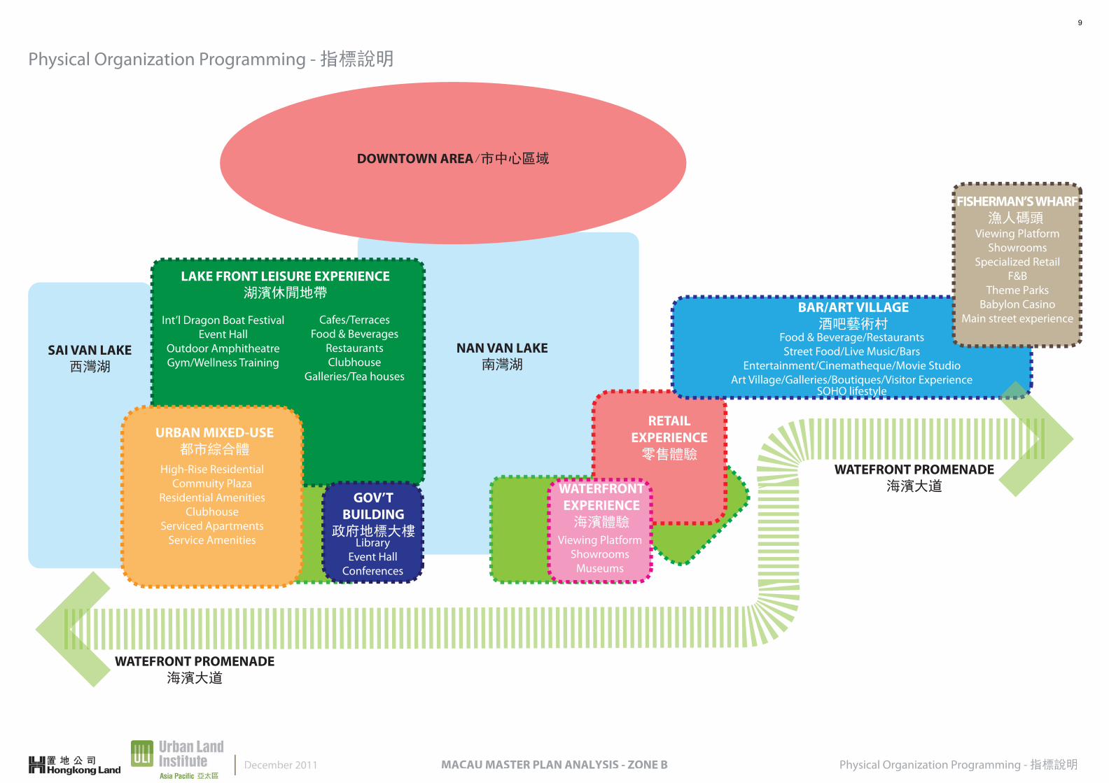
LAKE FRONT LEISURE EXPERIENCE湖濱休閒地帶
Food & Beverage/RestaurantsStreet Food/Live Music/Bars
Entertainment/Cinematheque/Movie StudioArt Village/Galleries/Boutiques/Visitor Experience
SOHO lifestyle
Int’l Dragon Boat FestivalEvent Hall
Outdoor AmphitheatreGym/Wellness Training
Cafes/TerracesFood & Beverages
RestaurantsClubhouse
Galleries/Tea houses
High-Rise ResidentialCommuity Plaza
Residential AmenitiesClubhouse
Serviced ApartmentsService Amenities
WATEFRONT PROMENADE海濱大道
WATEFRONT PROMENADE海濱大道
NAN VAN LAKE南灣湖
SAI VAN LAKE西灣湖
DOWNTOWN AREA/市中心區域
FISHERMAN’S WHARF 漁人碼頭
Viewing PlatformShowrooms
Specialized RetailF&B
Theme ParksBabylon Casino
Main street experience
URBAN MIXED-USE都市綜合體
LibraryEvent Hall
Conferences
GOV’TBUILDING
政府地標大樓
RETAILEXPERIENCE零售體驗
Viewing PlatformShowrooms
Museums
WATERFRONTEXPERIENCE海濱體驗
BAR/ART VILLAGE酒吧藝術村
December 2011
9
Area Tabulation Analysis:Preferred Scenario - 面積功能分析:建議分析MACAU MASTER PLAN ANALYSIS - ZONE B
N
0m 50m 100m 200m
Government-use/政府用途
Cultural-use/文化用途
Commercial-use/商業用途
Mixed-use/綜合體
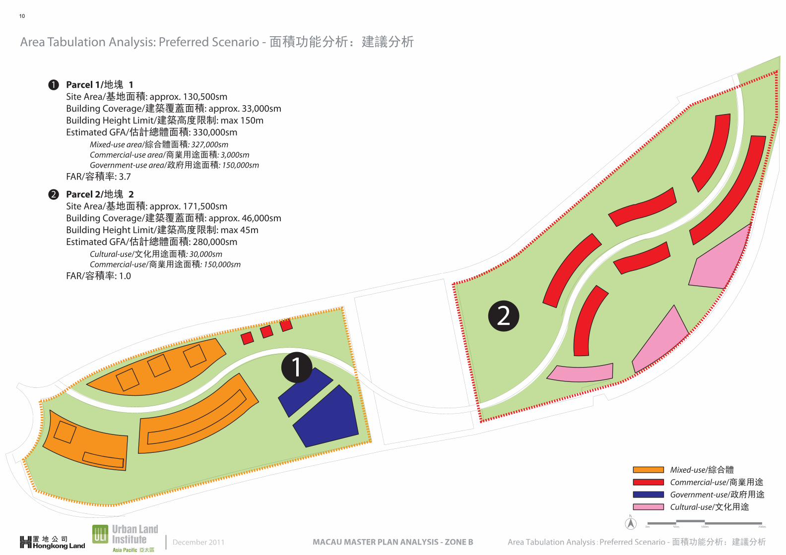
1 Parcel 1/地塊 1Site Area/基地面積: approx. 130,500smBuilding Coverage/建築覆蓋面積: approx. 33,000smBuilding Height Limit/建築高度限制: max 150mEstimated GFA/估計總體面積: 330,000sm Mixed-use area/綜合體面積: 327,000sm Commercial-use area/商業用途面積: 3,000sm Government-use area/政府用途面積: 150,000smFAR/容積率: 3.7
2 Parcel 2/地塊 2Site Area/基地面積: approx. 171,500smBuilding Coverage/建築覆蓋面積: approx. 46,000smBuilding Height Limit/建築高度限制: max 45mEstimated GFA/估計總體面積: 280,000sm Cultural-use/文化用途面積: 30,000sm Commercial-use/商業用途面積: 150,000smFAR/容積率: 1.0
Area Tabulation Analysis: Preferred Scenario - 面積功能分析:建議分析
December 2011
1
2
10
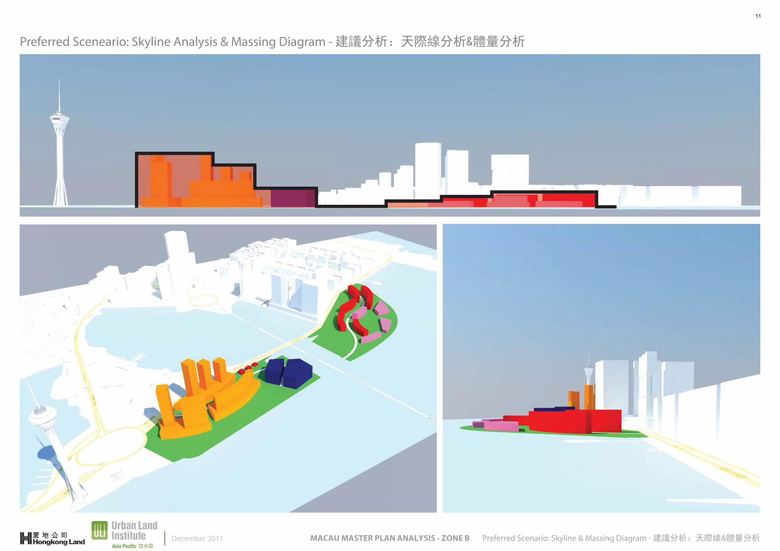
Preferred Sceneario: Skyline Analysis & Massing Diagram - 建議分析:天際線分析&體量分析
Preferred Scenario: Skyline & Massing Diagram - 建議分析:天際線&體量分析MACAU MASTER PLAN ANALYSIS - ZONE BDecember 2011
11

Physical Organization Programming - 指標說明MACAU MASTER PLAN ANALYSIS - ZONE BDecember 2011
01 WATERFRONTPROMENADE海濱大道
02 WATERFRONTEXPERIENCE海濱體驗
03 LAKEFRONT
LEISURE湖濱休閒地帶
04 URBAN
MIXED-USE都市綜合體
05 RETAIL
EXPERIENCE零售體驗
06 BAR/
ART VILLAGE酒吧藝術村
07 GOV’T
BUILDINGS政府地標大樓
08FISHERMAN’S
WHARF漁人碼頭
09OPEN SPACES
公共空間
> UNIQUELY EXPERIENTIAL 特有體驗> BOLD & UNIQUE 大膽&獨一無二> ENTERTAINMENT SOCIAL HUB 娛樂社交中心> LIFESTYLE COMMUNITY 生活社區> A LIVING EXPERIENCE BRAND 生活體驗品牌
24-HOUR CITY COLLECTIVE EXPERIENCE24小時都市集合體驗
LAKE FRONT LEISURE EXPERIENCE湖濱休閒地帶
Food & Beverage/RestaurantsStreet Food/Live Music/Bars
Entertainment/Cinematheque/Movie StudioArt Village/Galleries/Boutiques/Visitor Experience
SOHO lifestyle
Int’l Dragon Boat FestivalEvent Hall
Outdoor AmphitheatreGym/Wellness Training
Cafes/TerracesFood & Beverages
RestaurantsClubhouse
Galleries/Tea houses
High-Rise ResidentialCommuity Plaza
Residential AmenitiesClubhouse
Serviced ApartmentsService Amenities
WATEFRONT PROMENADE海濱大道
WATEFRONT PROMENADE海濱大道
NAN VAN LAKE南灣湖
SAI VAN LAKE西灣湖
DOWNTOWN AREA/市中心區域
FISHERMAN’S WHARF 漁人碼頭
Viewing PlatformShowrooms
Specialized RetailF&B
Theme ParksBabylon Casino
Main street experience
URBAN MIXED-USE都市綜合體
LibraryEvent Hall
Conferences
GOV’TBUILDING
政府地標大樓
RETAILEXPERIENCE零售體驗
Viewing PlatformShowrooms
Museums
WATERFRONTEXPERIENCE海濱體驗
BAR/ART VILLAGE酒吧藝術村
12
Physical Organization Programming - 指標說明MACAU MASTER PLAN ANALYSIS - ZONE B
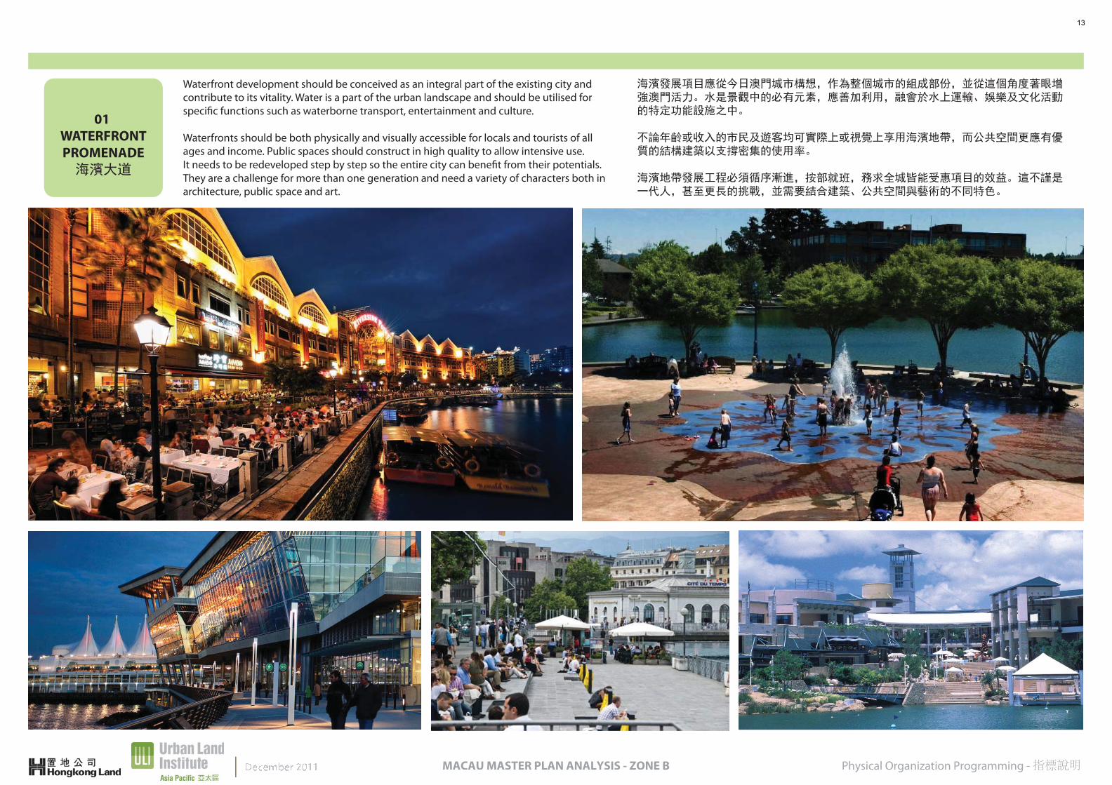
01 WATERFRONTPROMENADE海濱大道
Waterfront development should be conceived as an integral part of the existing city and contribute to its vitality. Water is a part of the urban landscape and should be utilised for specific functions such as waterborne transport, entertainment and culture.
Waterfronts should be both physically and visually accessible for locals and tourists of all ages and income. Public spaces should construct in high quality to allow intensive use.It needs to be redeveloped step by step so the entire city can benefit from their potentials. They are a challenge for more than one generation and need a variety of characters both in architecture, public space and art.
海濱發展項目應從今日澳門城市構想,作為整個城市的組成部份,並從這個角度著眼增強澳門活力。水是景觀中的必有元素,應善加利用,融會於水上運輸、娛樂及文化活動的特定功能設施之中。
不論年齡或收入的市民及遊客均可實際上或視覺上享用海濱地帶,而公共空間更應有優質的結構建築以支撐密集的使用率。
海濱地帶發展工程必須循序漸進,按部就班,務求全城皆能受惠項目的效益。這不謹是一代人,甚至更長的挑戰,並需要結合建築、公共空間與藝術的不同特色。
13
02 WATERFRONTEXPERIENCE海濱體驗
Physical Organization Programming - 指標說明MACAU MASTER PLAN ANALYSIS - ZONE B
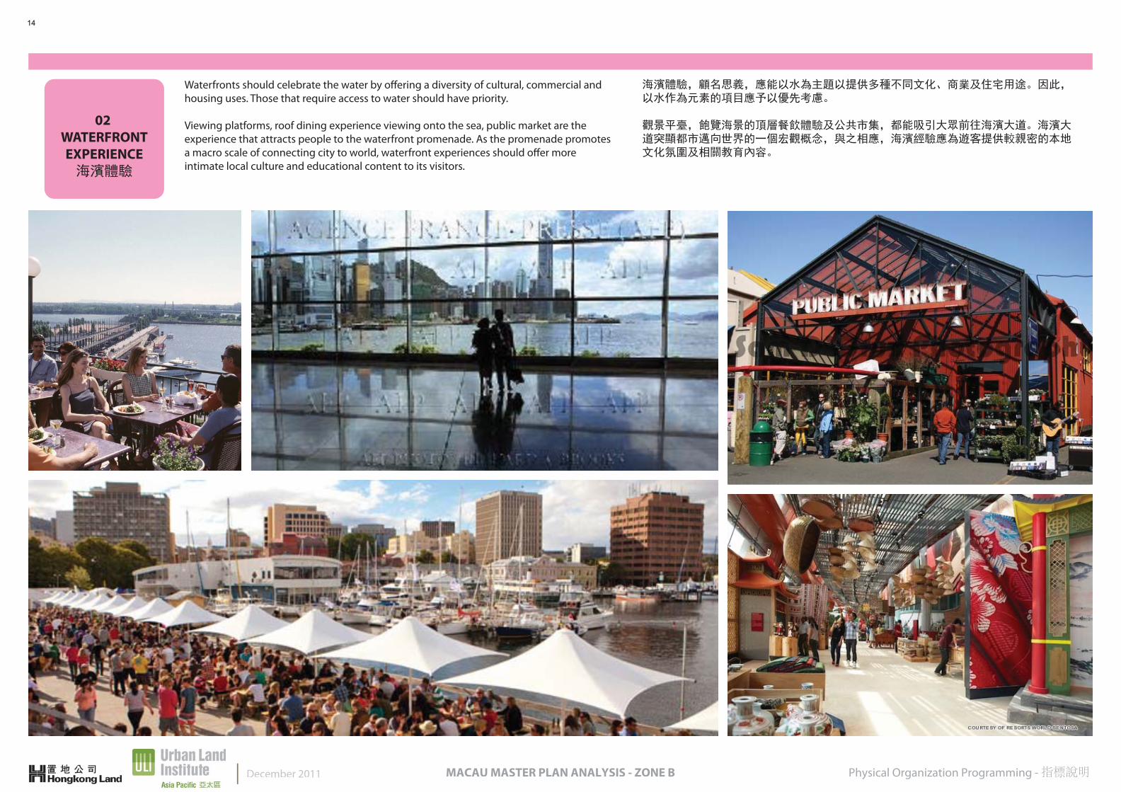
Waterfronts should celebrate the water by offering a diversity of cultural, commercial and housing uses. Those that require access to water should have priority.
Viewing platforms, roof dining experience viewing onto the sea, public market are the experience that attracts people to the waterfront promenade. As the promenade promotes a macro scale of connecting city to world, waterfront experiences should offer more intimate local culture and educational content to its visitors.
海濱體驗,顧名思義,應能以水為主題以提供多種不同文化、商業及住宅用途。因此,以水作為元素的項目應予以優先考慮。
觀景平臺,飽覽海景的頂層餐飲體驗及公共市集,都能吸引大眾前往海濱大道。海濱大道突顯都市邁向世界的一個宏觀概念,與之相應,海濱經驗應為遊客提供較親密的本地文化氛圍及相關教育內容。
December 2011
14

03 LAKEFRONT
LEISURE湖濱休閒地帶
Physical Organization Programming - 指標說明MACAU MASTER PLAN ANALYSIS - ZONE B
Lakefront leisure focuses on sports and culture, promoting a healthy lifestyle to its people. Programmed activities such as international Dragon boat festival competition to daily canoe practice for athletes, lakefront area can provide a gathering place for enhancing the sports’ spirit as well as a new athlete campus focusing on water sports which can employ both Nan Van Lake side and Sai Van Lake side.
In order to enhance the daily use of the lakefront, low-rise F&B and retail market place should also be promoted in the area as a new leisure-entertainment place for people to hangout.
湖濱休閒地帶著重的是運動及文化,向人們推廣健康生活。計劃內容包括國際龍舟節競賽及運動員的獨木舟練習。湖濱休閒地帶成為運動員聚集的交流場所,既能提升運動精神,亦提供一個全新運動員校園區,在南灣湖及西灣湖邊集中舉辦水上運動。
為增強湖濱每日使用率,可在地段內開設低層飲料食品及零售市集,並將之推廣為湖濱休閒娛樂休憩場所。
15
04 URBAN
MIXED-USE都市綜合體
Physical Organization Programming - 指標說明MACAU MASTER PLAN ANALYSIS - ZONE B
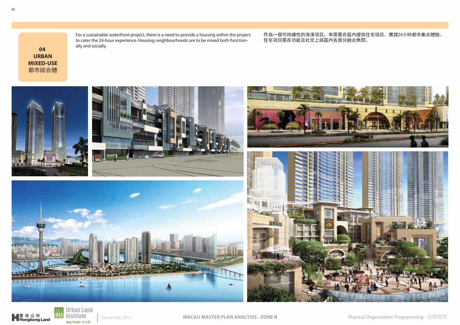
For a sustainable waterfront project, there is a need to provide a housing within the project to cater the 24-hour experience. Housing neighbourhoods are to be mixed both function-ally and socially.
作為一個可持續性的海濱項目,有需要在區內提供住宅項目,實踐24小時都市集合體驗。住宅項目需在功能及社交上與區內各部分融合無間。
December 2011
16
05 RETAIL
EXPERIENCE零售體驗
Physical Organization Programming - 指標說明MACAU MASTER PLAN ANALYSIS - ZONE B
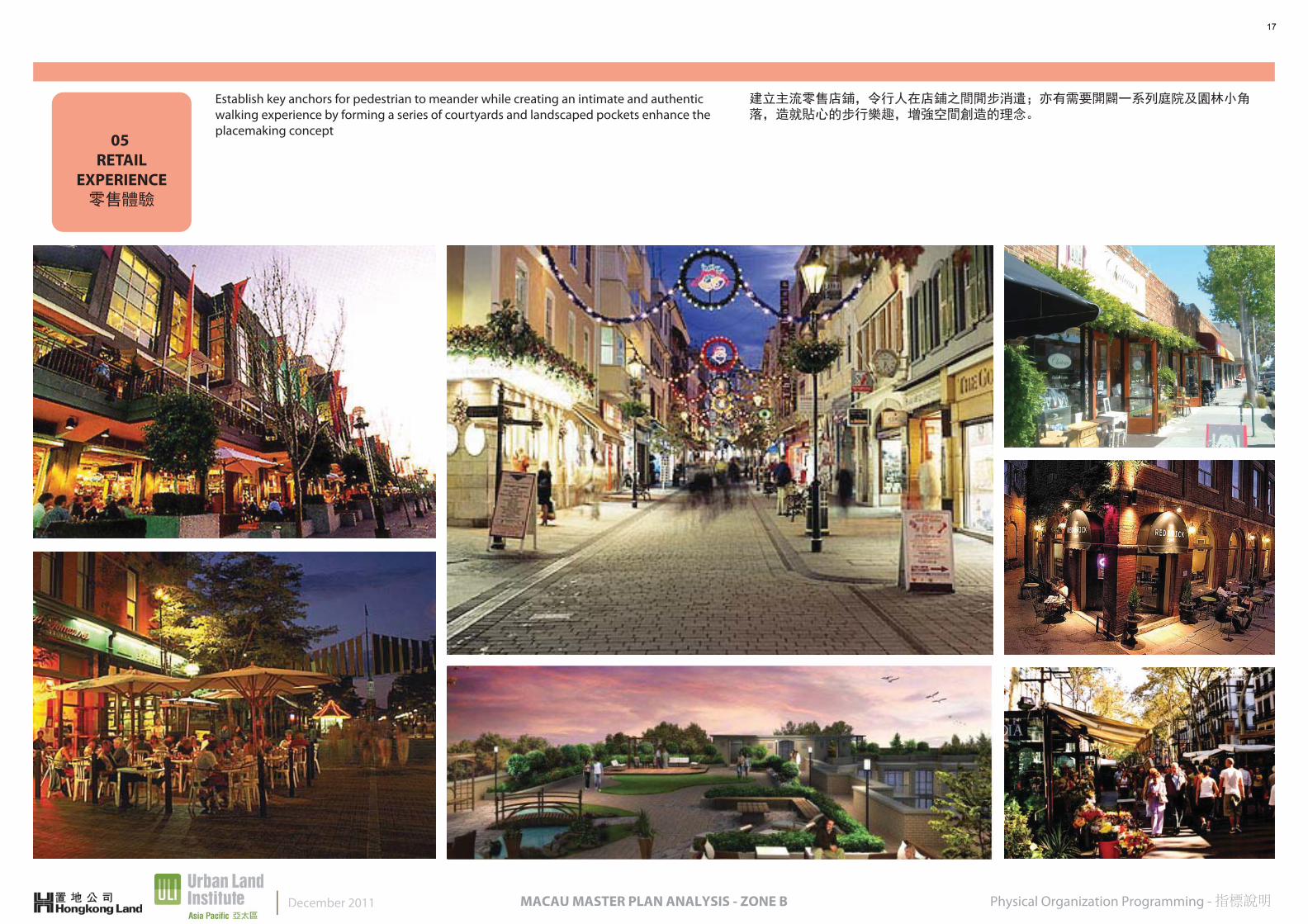
Establish key anchors for pedestrian to meander while creating an intimate and authentic walking experience by forming a series of courtyards and landscaped pockets enhance the placemaking concept
建立主流零售店鋪,令行人在店鋪之間閒步消遣;亦有需要開闢一系列庭院及園林小角落,造就貼心的步行樂趣,增強空間創造的理念。
December 2011
17
06 BAR/
ART VILLAGE酒吧藝術村
Physical Organization Programming - 指標說明MACAU MASTER PLAN ANALYSIS - ZONE B
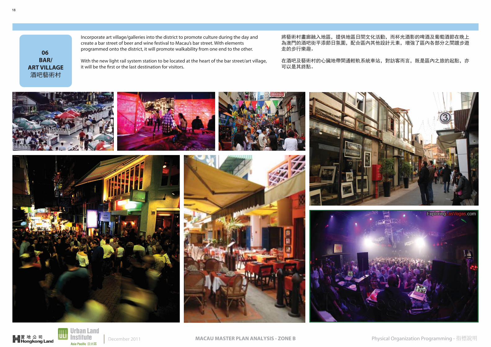
Incorporate art village/galleries into the district to promote culture during the day and create a bar street of beer and wine festival to Macau’s bar street. With elements programmed onto the district, it will promote walkability from one end to the other.
With the new light rail system station to be located at the heart of the bar street/art village, it will be the first or the last destination for visitors.
將藝術村畫廊融入地區,提供地區日間文化活動,而杯光酒影的啤酒及葡萄酒節在晚上為澳門的酒吧街平添節日氛圍,配合區內其他設計元素,增強了區內各部分之間踱步遊走的步行樂趣。
在酒吧及藝術村的心臟地帶開通輕軌系統車站,對訪客而言,既是區內之旅的起點,亦可以是其終點。
December 2011
18
07 GOV’T
BUILDING政府地標大樓
Physical Organization Programming - 指標說明MACAU MASTER PLAN ANALYSIS - ZONE B
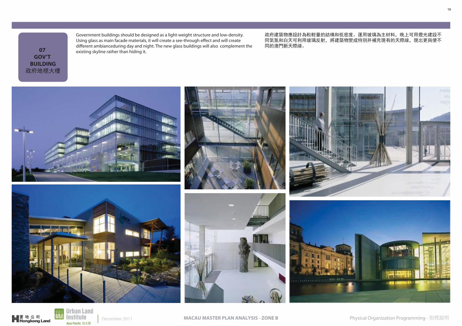
Government buildings should be designed as a light-weight structure and low-density. Using glass as main facade materials, it will create a see-through effect and will create different ambianceduring day and night. The new glass buildings will also complement the existing skyline rather than hiding it.
政府建築物應設計為較輕量的結構和低密度。運用玻璃為主材料,晚上可用燈光建設不同氣氛和白天可利用玻璃反射,將建築物變成特別并補充現有的天際線,現出更與便不同的澳門新天際線。
December 2011
19
08FISHERMAN’S
WHARF漁人碼頭
Physical Organization Programming - 指標說明MACAU MASTER PLAN ANALYSIS - ZONE B
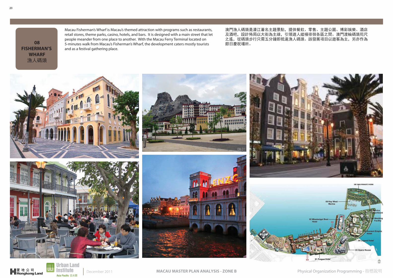
Macau Fisherman’s Wharf is Macau’s themed attraction with programs such as restaurants, retail stores, theme parks, casino, hotels, and bars. It is designed with a main street that let people meander from one place to another. With the Macau Ferry Terminal located on 5-minutes walk from Macau’s Fisherman’s Wharf, the development caters mostly tourists and as a festival gathering place.
澳門漁人碼頭是濠江著名主題景點,提供餐飲、零售、主題公園、博彩娛樂、酒店及酒吧,設計佈局以大街為主線,引領遊人縱橫徘徊各區之間。澳門渡輪碼頭咫尺之遙,從碼頭步行只需五分鐘即抵達漁人碼頭。該發展項目以遊客為主,另亦作為節日慶祝場所。
December 2011
20
09OPEN SPACES
公共空間
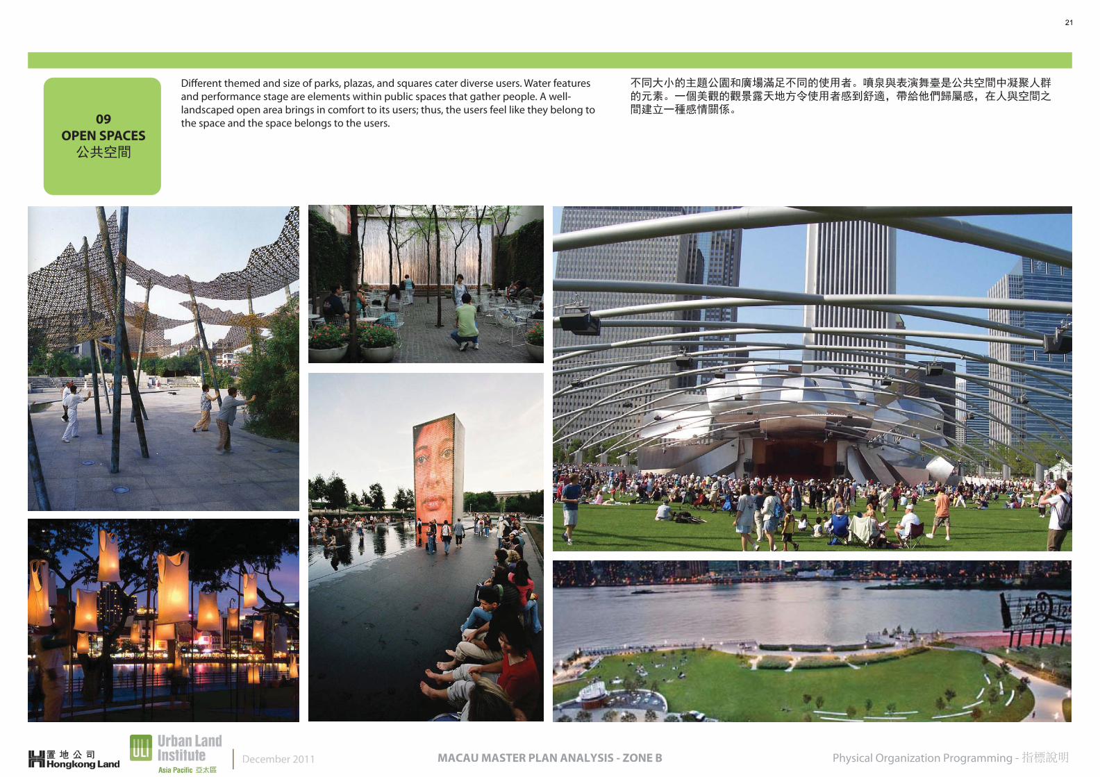
Physical Organization Programming - 指標說明MACAU MASTER PLAN ANALYSIS - ZONE B
Different themed and size of parks, plazas, and squares cater diverse users. Water features and performance stage are elements within public spaces that gather people. A well-landscaped open area brings in comfort to its users; thus, the users feel like they belong to the space and the space belongs to the users.
不同大小的主題公園和廣場滿足不同的使用者。噴泉與表演舞臺是公共空間中凝聚人群的元素。一個美觀的觀景露天地方令使用者感到舒適,帶給他們歸屬感,在人與空間之間建立一種感情關係。
December 2011
21
MACAU MASTER PLAN ANALYSIS - ZONE B
CONCLUSIONIncorporating the strengths and resources of the city of Macau, the planning for Zone B needs to be carefully though-through in order to maximize the strengths of the site for future development.
Seven Principles suggested: 1) Create a meandering main street to promote walkability 2) Connectivity of the different districts create pedestrian-friendly spaces 3) Mixed-use and density are key elements to a successful public space 4) Promote diversity in public spaces 5) Quality of architecture and urban design 6) Smart Transportation 7) Sustainability
With the commitment of enhancing the environment and to sustain the natural assets of the site while understanding its context in the broader regional system, the new planning of the area can highly improved and maximize the usage of the space.
本規劃嘗試將澳門的強項及資源融會為一。新城B區的規劃需仔細考慮清楚,使該址的未來發展獲得最大發揮的優勢。
建議的七項原則: 1)創建一個環迴曲折的大道以增強可步行性 2)不同地區串聯起來的連貫性造成以行人為本的空間 3)多用途與密度性是構成成功公共空間的關鍵因素 4)提升公共空間的多元性 5)建築質量與城市設計 6)智能交通運輸 7)可持續性
這個新規劃致力提升位址內的環境效益,令大自然資產生生不息,並將發展項目置於整個地區系統範圍之中,這樣,新規劃可提升和發揮最大的空間效益。
December 2011
22
MACAU MASTER PLAN ANALYSIS - ZONE B
APPENDIXFollowing assumptions are generated based on the information published by the Macau Government in order to facili-tate the comparison analysis generated for the preferred scenario presented.
下列建議由澳門政府公佈的資訊,這些建議有助我們對方案所作的對比進行分析。
December 2011
23
N
0m 50m 100m 200m
1
2
3
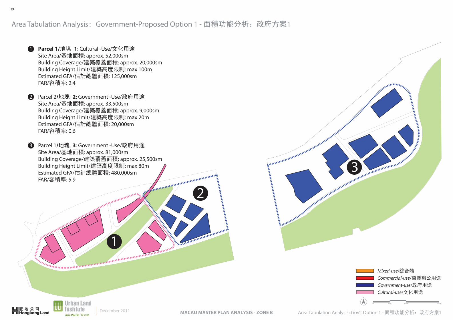
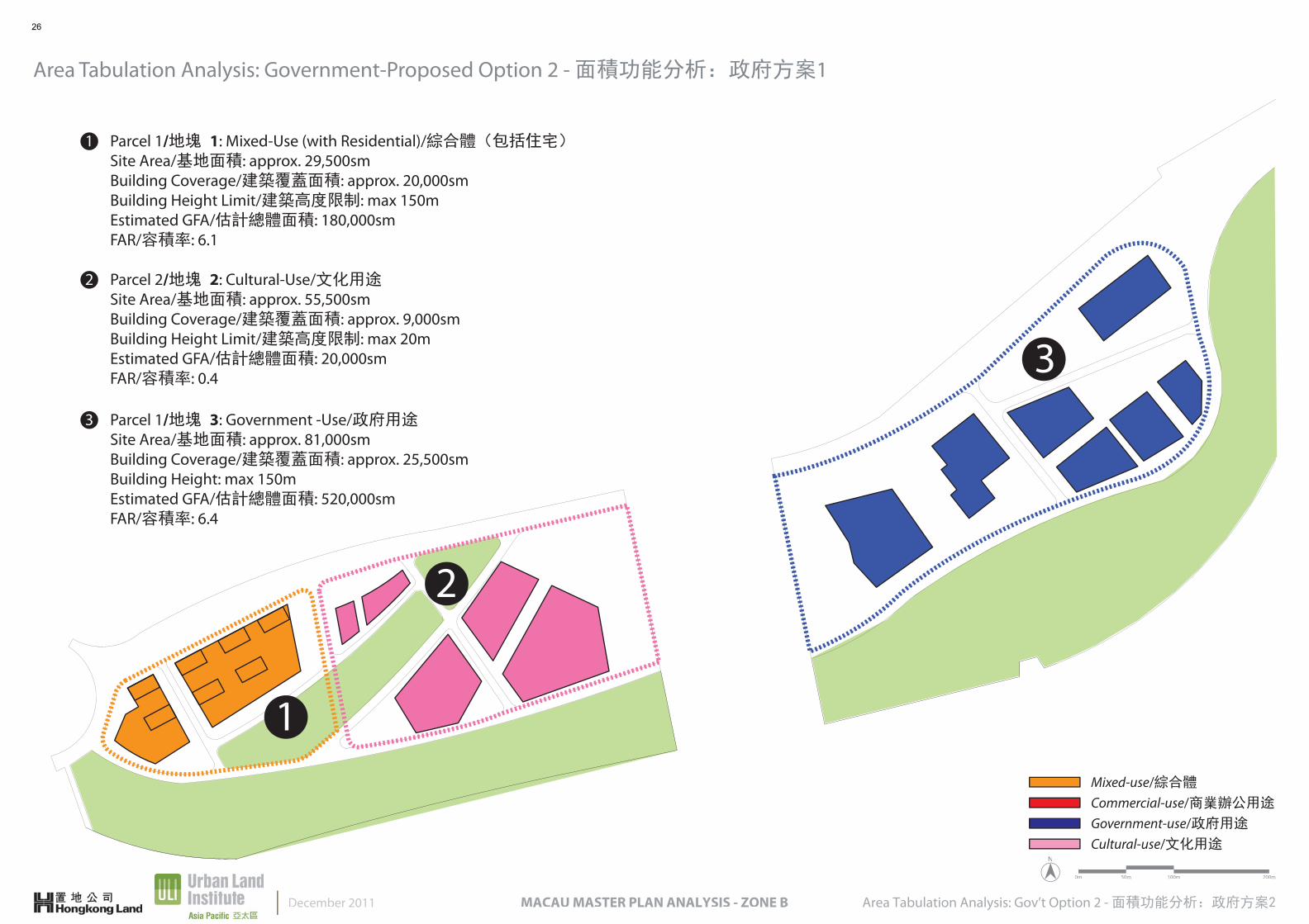
Parcel 1/地塊 1: Cultural -Use/文化用途Site Area/基地面積: approx. 52,000smBuilding Coverage/建築覆蓋面積: approx. 20,000smBuilding Height Limit/建築高度限制: max 100mEstimated GFA/估計總體面積: 125,000smFAR/容積率: 2.4
2 Parcel 2/地塊 2: Government -Use/政府用途Site Area/基地面積: approx. 33,500smBuilding Coverage/建築覆蓋面積: approx. 9,000smBuilding Height Limit/建築高度限制: max 20mEstimated GFA/估計總體面積: 20,000smFAR/容積率: 0.6
3 Parcel 1/地塊 3: Government -Use/政府用途Site Area/基地面積: approx. 81,000smBuilding Coverage/建築覆蓋面積: approx. 25,500smBuilding Height Limit/建築高度限制: max 80mEstimated GFA/估計總體面積: 480,000smFAR/容積率: 5.9
Area Tabulation Analysis:Government-Proposed Option 1 - 面積功能分析:政府方案1
1
Area Tabulation Analysis:Gov’t Option 1 - 面積功能分析:政府方案1MACAU MASTER PLAN ANALYSIS - ZONE BDecember 2011
Government-use/政府用途
Cultural-use/文化用途
Commercial-use/商業辦公用途
Mixed-use/綜合體
24
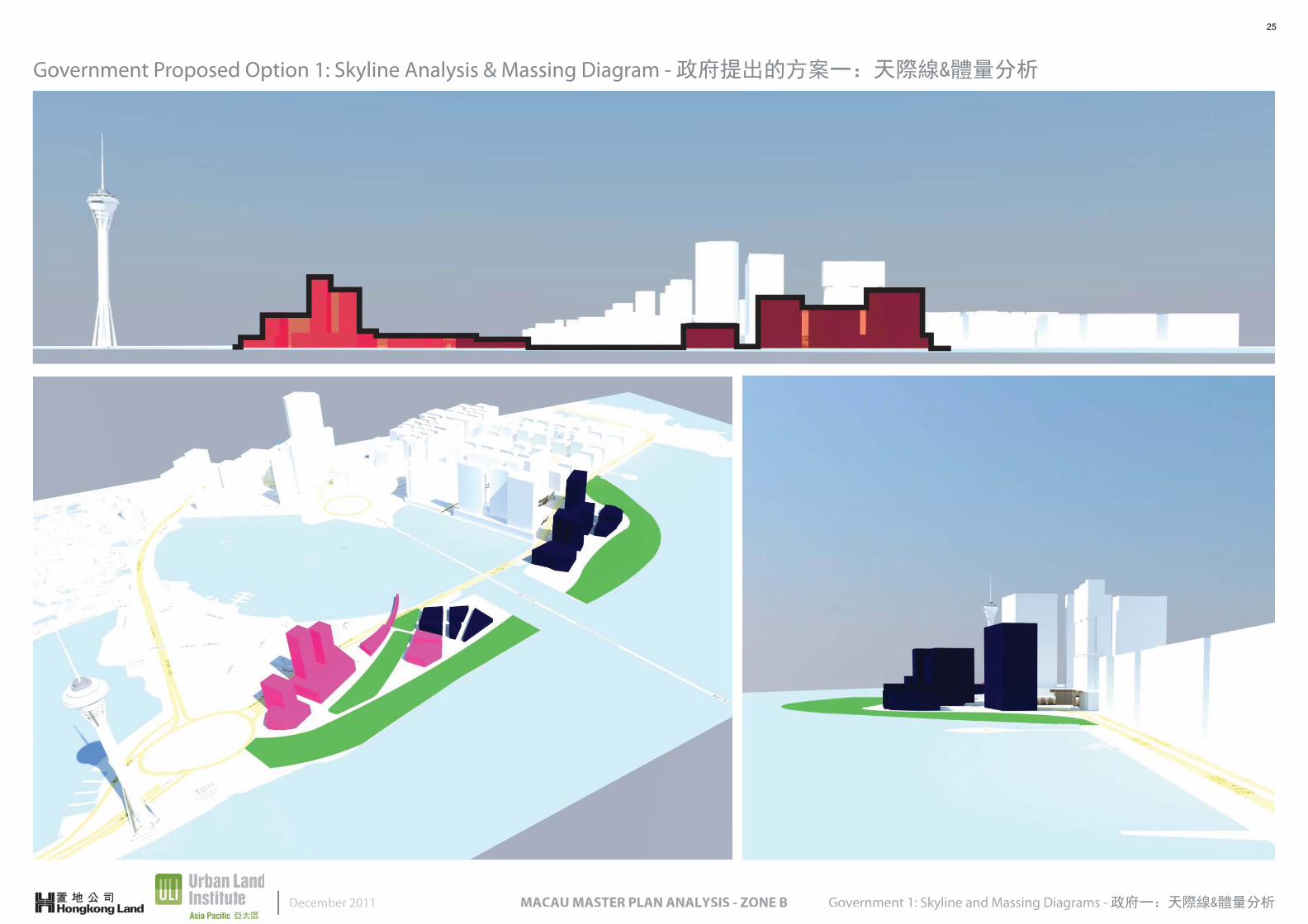
Government Proposed Option 1: Skyline Analysis & Massing Diagram - 政府提出的方案一:天際線&體量分析
Government 1: Skyline and Massing Diagrams - 政府一:天際線&體量分析MACAU MASTER PLAN ANALYSIS - ZONE BDecember 2011
25
N
0m 50m 100m 200m
1
1
2
3
Parcel 1/地塊 1: Mixed-Use (with Residential)/綜合體(包括住宅)Site Area/基地面積: approx. 29,500smBuilding Coverage/建築覆蓋面積: approx. 20,000smBuilding Height Limit/建築高度限制: max 150mEstimated GFA/估計總體面積: 180,000smFAR/容積率: 6.1
2 Parcel 2/地塊 2: Cultural-Use/文化用途Site Area/基地面積: approx. 55,500smBuilding Coverage/建築覆蓋面積: approx. 9,000smBuilding Height Limit/建築高度限制: max 20mEstimated GFA/估計總體面積: 20,000smFAR/容積率: 0.4
3 Parcel 1/地塊 3: Government -Use/政府用途Site Area/基地面積: approx. 81,000smBuilding Coverage/建築覆蓋面積: approx. 25,500smBuilding Height: max 150mEstimated GFA/估計總體面積: 520,000smFAR/容積率: 6.4
Area Tabulation Analysis: Government-Proposed Option 2 - 面積功能分析:政府方案1
Area Tabulation Analysis: Gov’t Option 2 - 面積功能分析:政府方案2MACAU MASTER PLAN ANALYSIS - ZONE BDecember 2011
Government-use/政府用途
Cultural-use/文化用途
Commercial-use/商業辦公用途
Mixed-use/綜合體
26
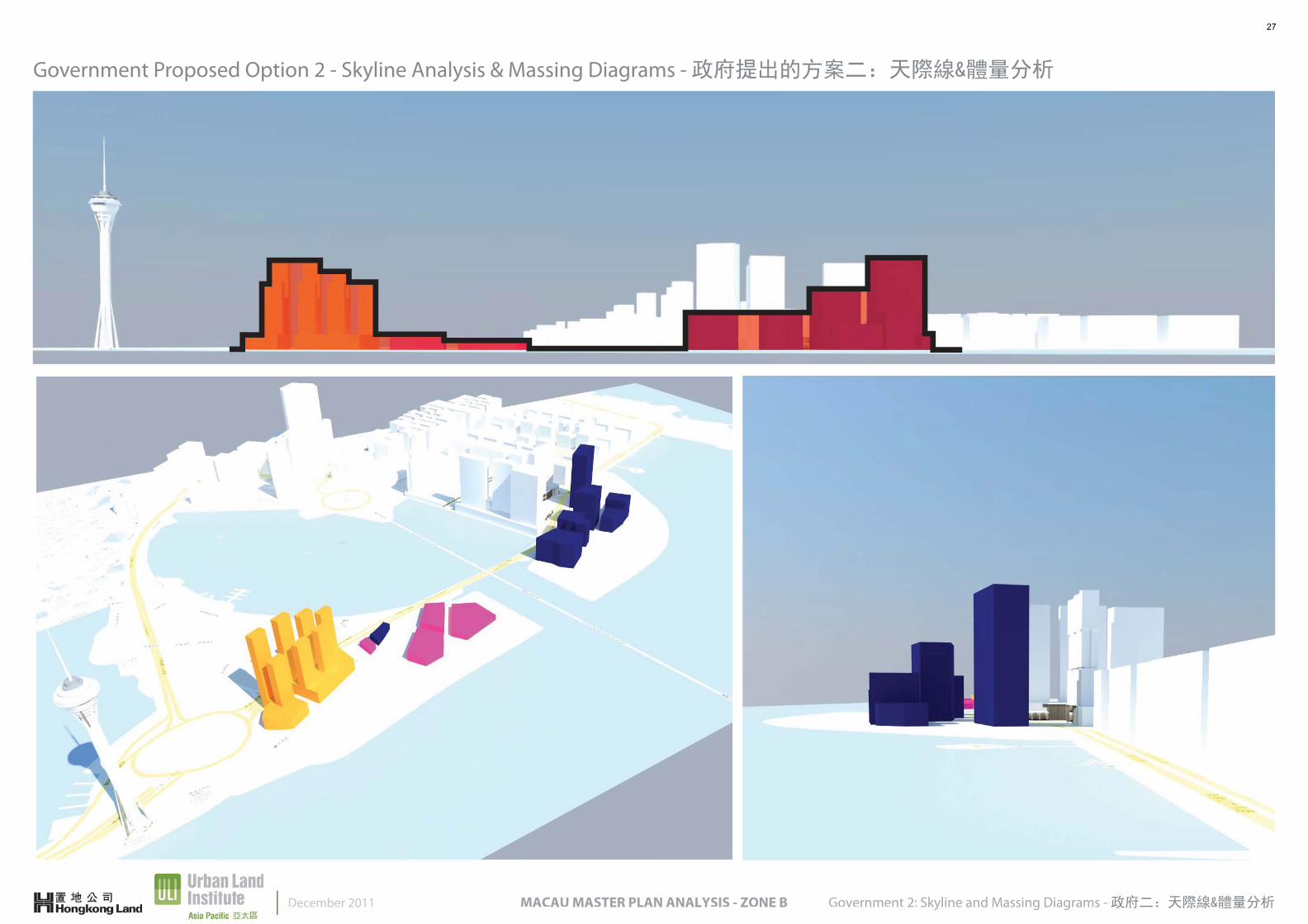
Government Proposed Option 2 - Skyline Analysis & Massing Diagrams - 政府提出的方案二:天際線&體量分析
Government 2: Skyline and Massing Diagrams - 政府二:天際線&體量分析MACAU MASTER PLAN ANALYSIS - ZONE BDecember 2011
27
About the Urban Land Institute
The Urban Land Institute is a 501(c) (3) nonprofit research and education organization supported by its members. Founded in 1936, the Institute now has nearly 30,000 members worldwide representing the entire spectrum of land use and real estate development disciplines, working in private enter-prise and public service. As the preeminent, multidisciplinary real estate forum, ULI facilitates the open exchange of ideas, information, and experience among local, national, and international industry leaders and policy makers dedicated to creating better places.
The mission of the Urban Land Institute is to provide leadership in the respon-sible use of land and in creating and sustaining thriving communities world-wide. ULI is committed to bringing together leaders from across the fields of real estate and land use policy to exchange best practices and serve commu-nity needs by:
Fostering collaboration within and beyond ULI’s membership through mentoring, dialogue, and problem-solving.
Exploring issues of urbanization, conservation, regeneration, land use, capital formation, and sustainable development.
Advancing land use policies and design practices that respect the uniqueness of both built and natural environments.
Sharing knowledge through education, applied research, publishing, and electronic media.
Sustaining a diverse global network of local practice and advisory efforts that address current and future challenges.
關於城市土地學會
城市土地學會是一個由旗下會員支援的非牟利的研究及教育機構。學會於1936年創立,在全球約有30,000名會員,分別代表著公、私營土地使用及房地產發展的各個領域。ULI提供一個卓越的跨界別房地產平台予本地、各國及國際行業領導者和決策者,促進意見、信息及經驗的公開交流,致力於創造更好的地方。
城市土地學會的宗旨是在負責任土地使用的議題上擔當領導角色,並促進全球活力社區的建立和持續發展。ULI致力透過以下方案匯聚房地產及土地使用政策的領袖,交流最佳範例及為社會服務:
透過師友指導、討論及從解決問題中,促進ULI的會員及非會員的合作。
探索城市化、保育、再生、土地使用、資本形成和可持續發展等問題。
推動土地使用政策及設計實踐,以維持建築及自然環境的獨特性。
通過教育、應用研究、刊物出版及電子媒體分享知識。
維繫一個多樣化的本地實踐及諮詢服務項目的全球網絡,以處理當前和未來的挑戰。