Embed Size (px)
Citation preview
LES TERRES 61A SONT LA PROPRIÉTÉ PRIVÉE DE LA PREMIÉRE NATION KEESEEKOOWENIN
Lac Moon
Lac Audy
RidingMountain
Silverton
Cabane deGrey Owl
Cabane Cairns
UV635
UV630
UV462
UV16
UV264
UV623
UV68
UV5
UV360
UV584
UV21
UV19
UV264
UV10 UV262UV42
UV16
UV10
UV361
UV20
UV354
UV16
UV45
UV10
UV276
UV480
UV472
UV359
UV470
UV83
UV5
UV270UV250
UV45
UV476
UV476
UV264
UV354
UV42
UV476
UV470
UV5
UV10
UV270
UV21
UV359
UV16
UV582
UV45
UV366
UV45
UV5
UV16
UV5
UV42
UV480
UV250
UV566
UV45
UV264
UV45
UV366
UV19
UV262
UV5
UV264
UV274
UV357
UV577
UV354
UV10
!13
!7
!15
!18
!2
!1
!11!5
!9
Audy
Baldy
Lac Clear
Curb
Custer
Edwa
rds
Fawn
Gunn
MacArthur
Menzies
Moo
n
Moose
Sout
h
PedenShoal
Round
Spruce
Tilson
Whi
rlpoo
l
Whitewater
Angusville
Birtle
Elphinstone
Erickson
Keeseekoowenin
Kelloe
Laurier
Makinak
McCreary
Menzie
Oakburn
Ochre River
Onanole
Rackham
Rolling River
Rossburn
Ste.Rose
du Lac
Sandy Lake
Shoal Lake
Solsgirth
Vista
Wasagaming
Waywayseecappo
!19
!3!4
!8
!6
!10
!23
!12
!21
!16 !22
!17
!20
!14
�
0 5 10 15 20 25 30 35 402,5km
ElkhornResort
Plage princip
ale
SentierLac-Sud
a
Was
ag
ming
Ta-w
a-pit
Buffalo
Colu m
bine
Fox
Route
10
Route
10
Was
agam
ing
CrocusDogwood
Goldenrod
Harebell
Hawthorn
Lily
Marigold
Orchid
Primula
Spru
ce
PuccoonTrillium
Viburnum
Balsam
Ta-wa-pit
Anse-aux-bateaux
Co lumine
b
oTENTiks
Patinoire
1,6
2,5
1,5
2,7
1,2
0,60,4
1,1
0,7
0,5
0,2
0,1
0,1
0,2
0,30,1
0 0,2 0,4 0,6 0,8 10,1km
Location de velos
Porte d’entrée Sud
Ta-w
a-pi
t
Mooswa Mooswa Est
Friends of RMNP
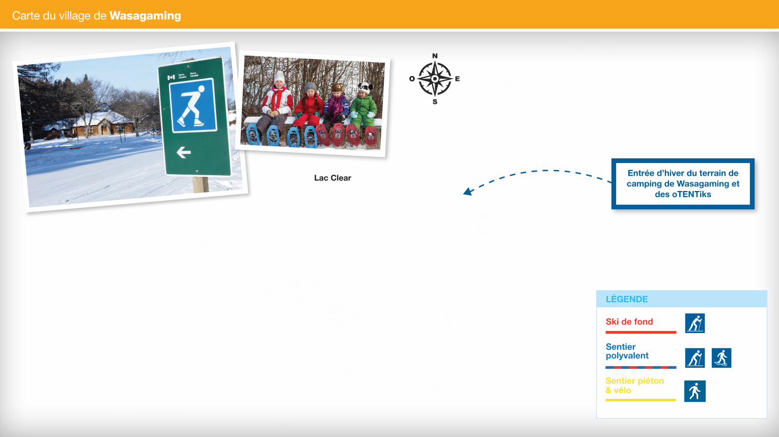
Carte du village de Wasagaming
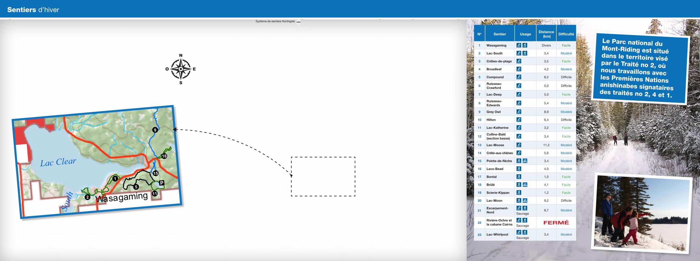
Sentiers d’hiver
Faites du ski de fond
Skiez sous le soleil, les étoiles ou les lumières en explorant le magnifique réseau de sentiers du terrain de camping de Wasagaming.
Aux abords de Wasagaming, vous pouvez pousser et glisser sur un sentier tracé pour le ski le long des 3,2 km de la boucle du lac Katherine.
Si vous recherchez plus de défis, essayez les sentiers Compound, Oak-Ridge ou Grey Owl. Nos sentiers de ski tracés n’attendent plus que vous!
No Sentier UsageDistance
(km)Difficulté
1 Wasagaming Divers Facile
2 Lac-South 3,4 Modéré
3 Crêtes-de-plage 3,5 Facile
4 Broadleaf 4,2 Modéré
5 Compound 8,2 Difficile
6Ruisseau-Crawford
5,0 Difficile
7 Lac-Deep 5,0 Facile
8Ruisseau-Edwards
5,4 Modéré
9 Grey Owl 8,9 Modéré
10 Hilton 6,4 Difficile
11 Lac-Katherine 3,2 Facile
12Colline-Bald (section basse)
3,4 Facile
13 Lac-Moose 11,2 Modéré
14 Crête-aux-chênes 5,6 Modéré
15 Pointe-de-flèche 3,4 Modéré
16 Lacs-Bead 4,0 Modéré
17 Boréal 1,0 Facile
18 Brûlé 4,1 Facile
19 Scierie-Kippan 1,2 Facile
20 Lac-Moon 9,2 Difficile
21Escarpement-Nord
Sauvage
8,7 Modéré
22Rivière-Ochre et la cabane Cairns
Sauvage
23 Lac-Whirlpool Sauvage
3,4 Modéré
Lac Clear
FERMÉFERMÉ
Lac Moon
Lac Audy
RidingMountain
Silverton
Cabane deGrey Owl
Cabane Cairns
UV635
UV630
UV462
UV16
UV264
UV623
UV68UV5
UV360
UV584
UV21
UV19
UV264
UV10 UV262
UV42
UV16
UV10
UV361
UV20
UV354
UV16
UV45
UV10
UV276
UV480
UV472
UV359
UV470
UV83
UV5
UV270UV250
UV45
UV476
UV476
UV264
UV354
UV42
UV476
UV470
UV5
UV10
UV270
UV21
UV359
UV16
UV582
UV45
UV366
UV45
UV5
UV16
UV5
UV42
UV480
UV250UV566
UV45
UV264
UV45
UV366
UV19
UV262
UV5
UV264
UV274
UV357
UV577
UV354
UV10
!18
!9
!15
!2
!1
!11!5
Audy
Baldy
Lac Clear
Curb
Custer Edwa
rds
Fawn
Gunn
MacArthur
Menzies
Moo
n
Moose
Sout
h
Peden
Shoal
Round
Spruce
Tilson
Whi
rlpoo
l
Whitewater
Angusville
Birtle
Elphinstone
Erickson
Keeseekoowenin
Kelloe
Laurier
Makinak
McCreary
Menzie
Oakburn
Ochre River
Onanole
Rackham
Rolling River
Rossburn
Ste.Rosedu Lac
Sandy Lake
Shoal Lake
Solsgirth
Vista
Wasagaming
Waywayseecappo
�
0 5 10 15 20 25 30 35 40
2.5
km
Le Parc national du Mont-Riding est situé dans le territoire visé par le Traité no 2, où nous travaillons avec les Premières Nations anishinabes signataires des traités no 2, 4 et 1.
Ski de fond
Sentier polyvalent
LÉGENDE
Sentier piéton & vélo
Entrée d’hiver du terrain de camping de Wasagaming et
des oTENTiks
Système de sentiers Northgate
LES TERRES 61A SONT LA PROPRIÉTÉ PRIVÉE DE LA PREMIÉRE NATION KEESEEKOOWENIN
Lac Moon
Lac Audy
RidingMountain
Silverton
Cabane deGrey Owl
Cabane Cairns
UV635
UV630
UV462
UV16
UV264
UV623
UV68
UV5
UV360
UV584
UV21
UV19
UV264
UV10 UV262UV42
UV16
UV10
UV361
UV20
UV354
UV16
UV45
UV10
UV276
UV480
UV472
UV359
UV470
UV83
UV5
UV270UV250
UV45
UV476
UV476
UV264
UV354
UV42
UV476
UV470
UV5
UV10
UV270
UV21
UV359
UV16
UV582
UV45
UV366
UV45
UV5
UV16
UV5
UV42
UV480
UV250
UV566
UV45
UV264
UV45
UV366
UV19
UV262
UV5
UV264
UV274
UV357
UV577
UV354
UV10
!13
!7
!15
!18
!2
!1
!11!5
!9
Audy
Baldy
Lac Clear
Curb
Custer
Edwa
rds
Fawn
Gunn
MacArthur
Menzies
Moo
n
Moose
Sout
h
Peden
Shoal
Round
Spruce
Tilson
Whi
rlpoo
l
Whitewater
Angusville
Birtle
Elphinstone
Erickson
Keeseekoowenin
Kelloe
Laurier
Makinak
McCreary
Menzie
Oakburn
Ochre River
Onanole
Rackham
Rolling River
Rossburn
Ste.Rose
du Lac
Sandy Lake
Shoal Lake
Solsgirth
Vista
Wasagaming
Waywayseecappo
!19
!3!4
!8
!6
!10
!23
!12
!21
!16 !22
!17
!20
!14
�
0 5 10 15 20 25 30 35 402,5km
ElkhornResort
Plage princip
ale
SentierLac-Sud
a
Was
ag
ming
Ta-w
a-pit
Buffalo
Colu m
bine
Fox
Route
10
Route
10
Was
agam
ing
CrocusDogwood
Goldenrod
Harebell
Hawthorn
Lily
Marigold
Orchid
Primula
Spru
ce
PuccoonTrillium
Viburnum
Balsam
Ta-wa-pit
Anse-aux-bateaux
Co lumine
b
oTENTiks
Patinoire
1,6
2,5
1,5
2,7
1,2
0,60,4
1,1
0,7
0,5
0,2
0,1
0,1
0,2
0,30,1
0 0,2 0,4 0,6 0,8 10,1km
Location de velos
Porte d’entrée Sud
Ta-w
a-pi
t
Mooswa Mooswa Est
Friends of RMNP
Carte du village de Wasagaming
Sentiers d’hiver
Faites du ski de fond
Skiez sous le soleil, les étoiles ou les lumières en explorant le magnifique réseau de sentiers du terrain de camping de Wasagaming.
Aux abords de Wasagaming, vous pouvez pousser et glisser sur un sentier tracé pour le ski le long des 3,2 km de la boucle du lac Katherine.
Si vous recherchez plus de défis, essayez les sentiers Compound, Oak-Ridge ou Grey Owl. Nos sentiers de ski tracés n’attendent plus que vous!
No Sentier UsageDistance
(km)Difficulté
1 Wasagaming Divers Facile
2 Lac-South 3,4 Modéré
3 Crêtes-de-plage 3,5 Facile
4 Broadleaf 4,2 Modéré
5 Compound 8,2 Difficile
6Ruisseau-Crawford
5,0 Difficile
7 Lac-Deep 5,0 Facile
8Ruisseau-Edwards
5,4 Modéré
9 Grey Owl 8,9 Modéré
10 Hilton 6,4 Difficile
11 Lac-Katherine 3,2 Facile
12Colline-Bald (section basse)
3,4 Facile
13 Lac-Moose 11,2 Modéré
14 Crête-aux-chênes 5,6 Modéré
15 Pointe-de-flèche 3,4 Modéré
16 Lacs-Bead 4,0 Modéré
17 Boréal 1,0 Facile
18 Brûlé 4,1 Facile
19 Scierie-Kippan 1,2 Facile
20 Lac-Moon 9,2 Difficile
21Escarpement-Nord
Sauvage
8,7 Modéré
22Rivière-Ochre et la cabane Cairns
Sauvage
23 Lac-Whirlpool Sauvage
3,4 Modéré
Lac Clear
FERMÉFERMÉ
Lac Moon
Lac Audy
RidingMountain
Silverton
Cabane deGrey Owl
Cabane Cairns
UV635
UV630
UV462
UV16
UV264
UV623
UV68UV5
UV360
UV584
UV21
UV19
UV264
UV10 UV262
UV42
UV16
UV10
UV361
UV20
UV354
UV16
UV45
UV10
UV276
UV480
UV472
UV359
UV470
UV83
UV5
UV270UV250
UV45
UV476
UV476
UV264
UV354
UV42
UV476
UV470
UV5
UV10
UV270
UV21
UV359
UV16
UV582
UV45
UV366
UV45
UV5
UV16
UV5
UV42
UV480
UV250UV566
UV45
UV264
UV45
UV366
UV19
UV262
UV5
UV264
UV274
UV357
UV577
UV354
UV10
!18
!9
!15
!2
!1
!11!5
Audy
Baldy
Lac Clear
Curb
Custer Edwa
rds
Fawn
Gunn
MacArthur
Menzies
Moo
n
Moose
Sout
h
Peden
Shoal
Round
Spruce
Tilson
Whi
rlpoo
l
Whitewater
Angusville
Birtle
Elphinstone
Erickson
Keeseekoowenin
Kelloe
Laurier
Makinak
McCreary
Menzie
Oakburn
Ochre River
Onanole
Rackham
Rolling River
Rossburn
Ste.Rosedu Lac
Sandy Lake
Shoal Lake
Solsgirth
Vista
Wasagaming
Waywayseecappo
�
0 5 10 15 20 25 30 35 40
2.5
km
Le Parc national du Mont-Riding est situé dans le territoire visé par le Traité no 2, où nous travaillons avec les Premières Nations anishinabes signataires des traités no 2, 4 et 1.
Ski de fond
Sentier polyvalent
LÉGENDE
Sentier piéton & vélo
Entrée d’hiver du terrain de camping de Wasagaming et
des oTENTiks
Système de sentiers Northgate