Embed Size (px)
Citation preview
Synthetic? Aperture? Radar!
이 훈 열
강원대학교지구물리학과
Systems and Signal Processing
강원대학교 자원개발연구소 세미나 – 2004 년 4 월 8 일
Radarrr rr rrr r rr r
Synthetic Aperture Radar – Systems and Signal Processing
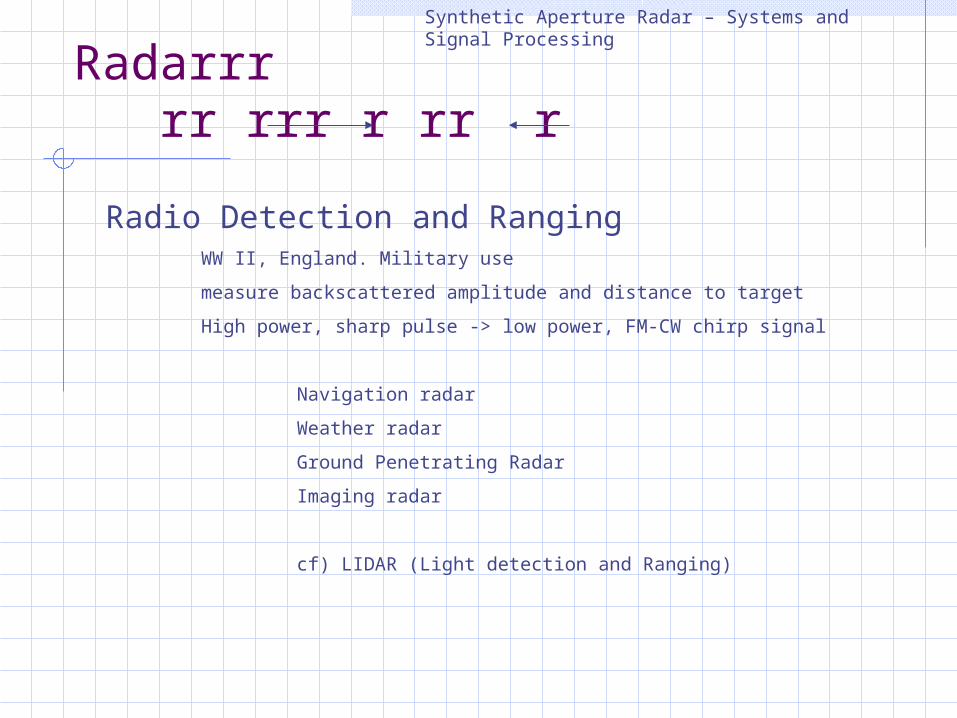
Radio Detection and RangingWW II, England. Military usemeasure backscattered amplitude and distance to target High power, sharp pulse -> low power, FM-CW chirp signal
Navigation radarWeather radarGround Penetrating RadarImaging radar
cf) LIDAR (Light detection and Ranging)
Imaging Radar
Synthetic Aperture Radar – Systems and Signal Processing
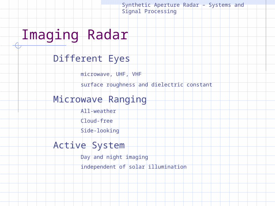
Different Eyesmicrowave, UHF, VHF surface roughness and dielectric constant
Microwave RangingAll-weatherCloud-freeSide-looking
Active SystemDay and night imagingindependent of solar illumination
ApertureSynthetic Aperture Radar – Systems and Signal Processing
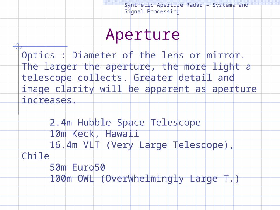
Optics : Diameter of the lens or mirror. The larger the aperture, the more light a telescope collects. Greater detail and image clarity will be apparent as aperture increases.
2.4m Hubble Space Telescope10m Keck, Hawaii16.4m VLT (Very Large Telescope), Chile50m Euro50100m OWL (OverWhelmingly Large T.)
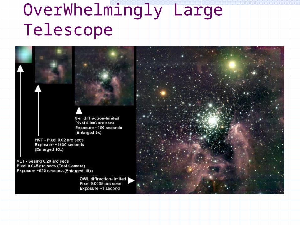
OverWhelmingly Large Telescope
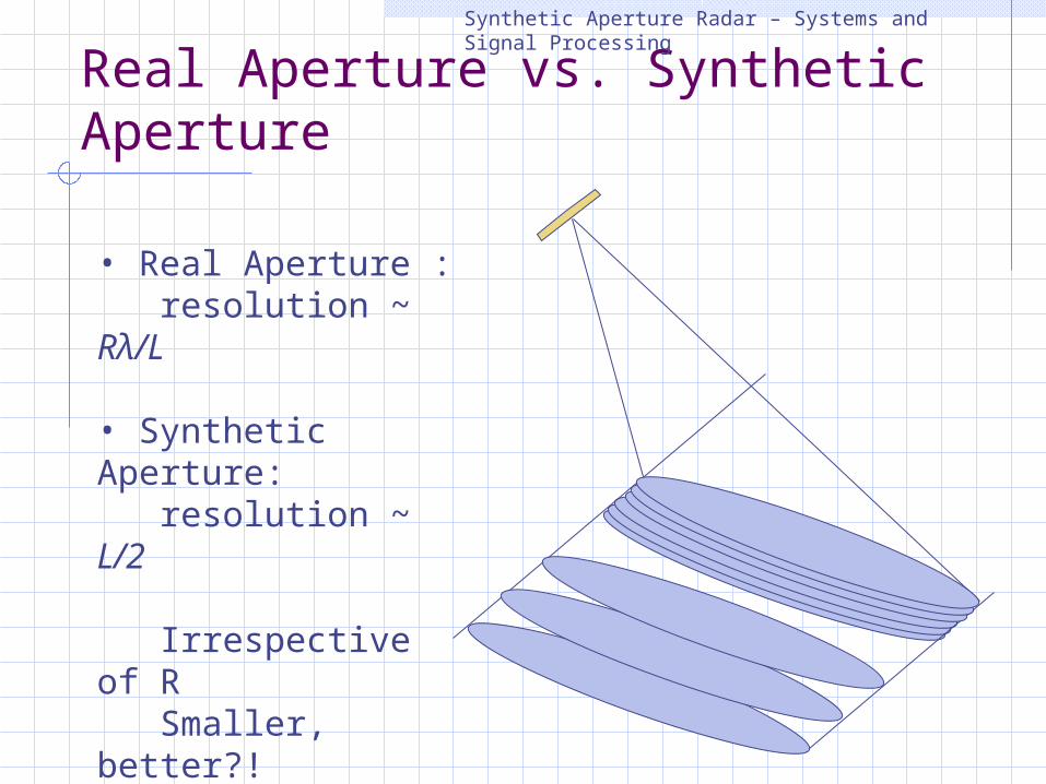
Real Aperture vs. Synthetic Aperture
Synthetic Aperture Radar – Systems and Signal Processing
• Real Aperture : resolution ~ Rλ/L
• Synthetic Aperture: resolution ~ L/2
Irrespective of R Smaller, better?! - Carl Wiley (1951)
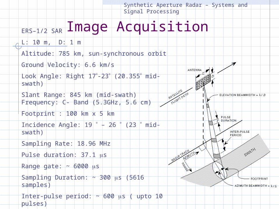
Image AcquisitionSynthetic Aperture Radar – Systems and Signal Processing
ERS–1/2 SAR L: 10 m, D: 1 mAltitude: 785 km, sun-synchronous orbit Ground Velocity: 6.6 km/sLook Angle: Right 17-23 (20.355 mid-swath) Slant Range: 845 km (mid-swath) Frequency: C- Band (5.3GHz, 5.6 cm)Footprint : 100 km x 5 kmIncidence Angle: 19 – 26 (23 mid-swath)Sampling Rate: 18.96 MHzPulse duration: 37.1 s Range gate: ~ 6000 s Sampling Duration: ~ 300 s (5616 samples) Inter-pulse period: ~ 600 s ( upto 10 pulses)Pulse Repetition Frequency: 1700 HzData Rate: 105 Mb/s (5 bits/sample)
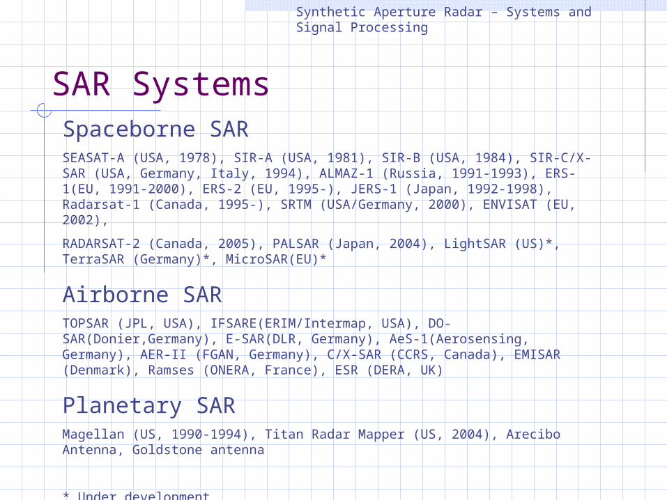
SAR Systems
Synthetic Aperture Radar – Systems and Signal Processing
Spaceborne SARSEASAT-A (USA, 1978), SIR-A (USA, 1981), SIR-B (USA, 1984), SIR-C/X-SAR (USA, Germany, Italy, 1994), ALMAZ-1 (Russia, 1991-1993), ERS-1(EU, 1991-2000), ERS-2 (EU, 1995-), JERS-1 (Japan, 1992-1998), Radarsat-1 (Canada, 1995-), SRTM (USA/Germany, 2000), ENVISAT (EU, 2002), RADARSAT-2 (Canada, 2005), PALSAR (Japan, 2004), LightSAR (US)*, TerraSAR (Germany)*, MicroSAR(EU)*
Airborne SARTOPSAR (JPL, USA), IFSARE(ERIM/Intermap, USA), DO-SAR(Donier,Germany), E-SAR(DLR, Germany), AeS-1(Aerosensing, Germany), AER-II (FGAN, Germany), C/X-SAR (CCRS, Canada), EMISAR (Denmark), Ramses (ONERA, France), ESR (DERA, UK)
Planetary SARMagellan (US, 1990-1994), Titan Radar Mapper (US, 2004), Arecibo Antenna, Goldstone antenna
* Under development

SAR System Modes
Synthetic Aperture Radar – Systems and Signal Processing
Target – the Earth or planets Vehicle – stationary, airborne, satellite, or spaceship Mode – monostatic and/or bistaticCarrier frequency – X, C, S, L, and/or P bandsPolarisation – HH, VV, VH, HV (single-pol, dual-pol, full-pol)Imaging geometry – strip, scan, spot
<examples>SIR-C/X-SAR: space shuttle, mono, L/C/X, full-pol. ERS-1/2, Envisat: Earth satellite, mono, C, VV.SRTM: space shuttle, mono/bistatic, C/X, HH/VV.Arecibo Antenna: planetary, stationary, mono/bi, multi-bands, multi-pol. Magellan, Cassini SAR: Venus and Titan, mono, S, HH.AIRSAR/TOPSAR: airborne, mono/bi, L/C/P, full-pol
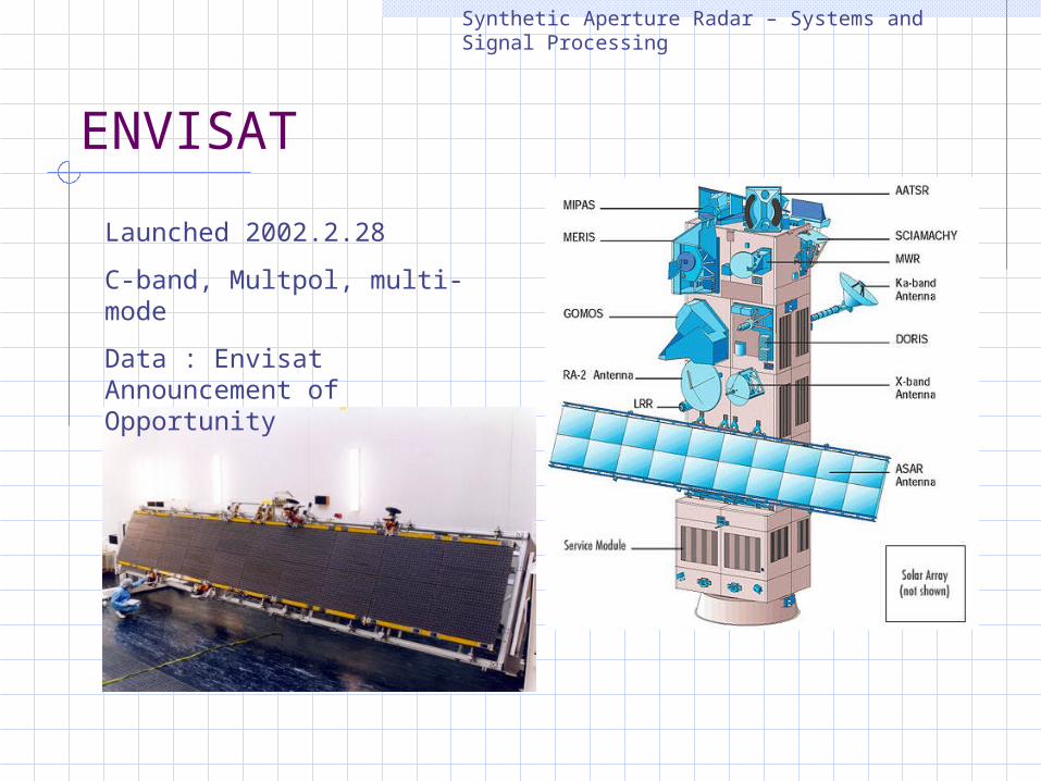
ENVISAT
Synthetic Aperture Radar – Systems and Signal Processing
Launched 2002.2.28C-band, Multpol, multi-modeData : Envisat Announcement of Opportunity

Image Domain
Synthetic Aperture Radar – Systems and Signal Processing
Azimuth (s)
Range (R)5616 pixels, 100 km
28,000 lines, 106 km
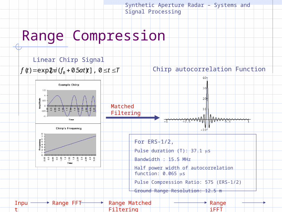
Range Compression
Synthetic Aperture Radar – Systems and Signal Processing
For ERS-1/2,Pulse duration (T): 37.1 s Bandwidth : 15.5 MHzHalf power width of autocorrelation function: 0.065 s Pulse Compression Ratio: 575 (ERS-1/2)Ground Range Resolution: 12.5 m
Matched Filtering
Chirp autocorrelation FunctionTttatfitf 0],)5.0(2exp[)( 0
Linear Chirp Signal
Range FFT Range iFFT
Range Matched Filtering
Input
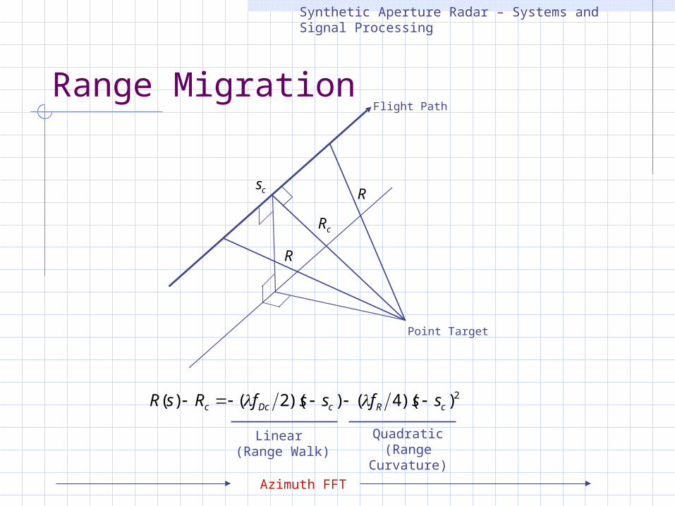
Range Migration
Synthetic Aperture Radar – Systems and Signal Processing
R
cR
cs
Point Target
R
Flight Path
2))(4())(2()( cRcDcc ssfssfRsR
Linear (Range Walk)
Quadratic(Range Curvature)
Azimuth FFT
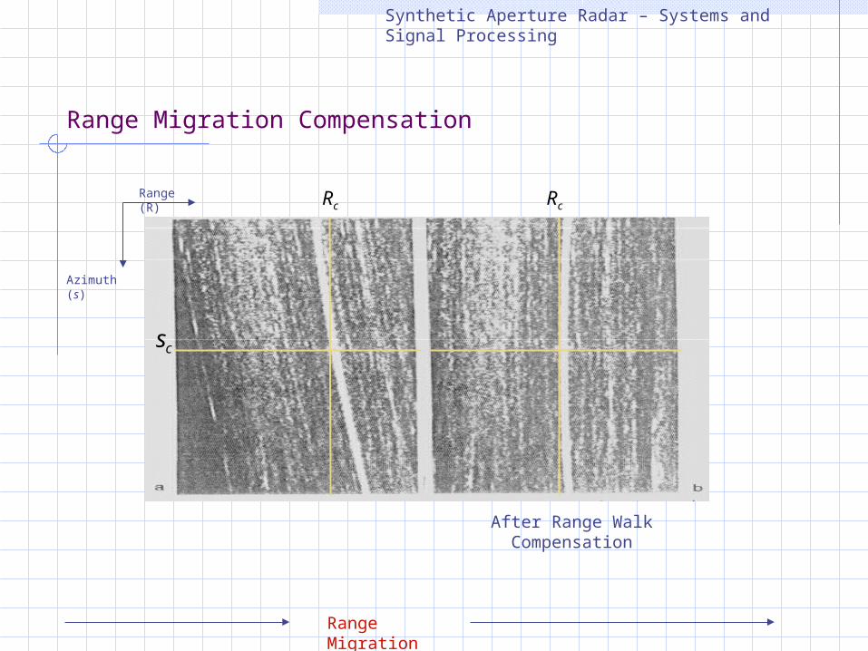
Range Migration Compensation
Synthetic Aperture Radar – Systems and Signal Processing
Range (R)
Azimuth (s)
cR cR
cs
After Range Walk Compensation
Range Migration
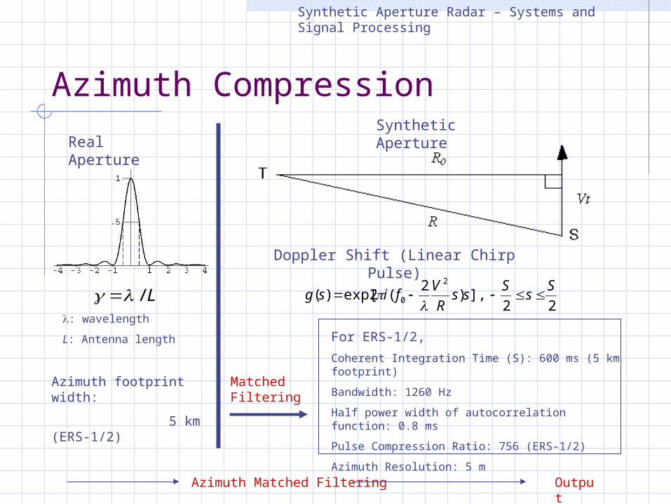
Azimuth Compression
Synthetic Aperture Radar – Systems and Signal Processing
L/
Real Aperture
: wavelengthL: Antenna length
Doppler Shift (Linear Chirp Pulse)
Azimuth footprint width: 5 km (ERS-1/2)
22],)2(2exp[)(
2
0SsSss
RVfisg
For ERS-1/2,Coherent Integration Time (S): 600 ms (5 km footprint)Bandwidth: 1260 HzHalf power width of autocorrelation function: 0.8 ms Pulse Compression Ratio: 756 (ERS-1/2)Azimuth Resolution: 5 m
Synthetic Aperture
Matched Filtering
Azimuth Matched Filtering Output
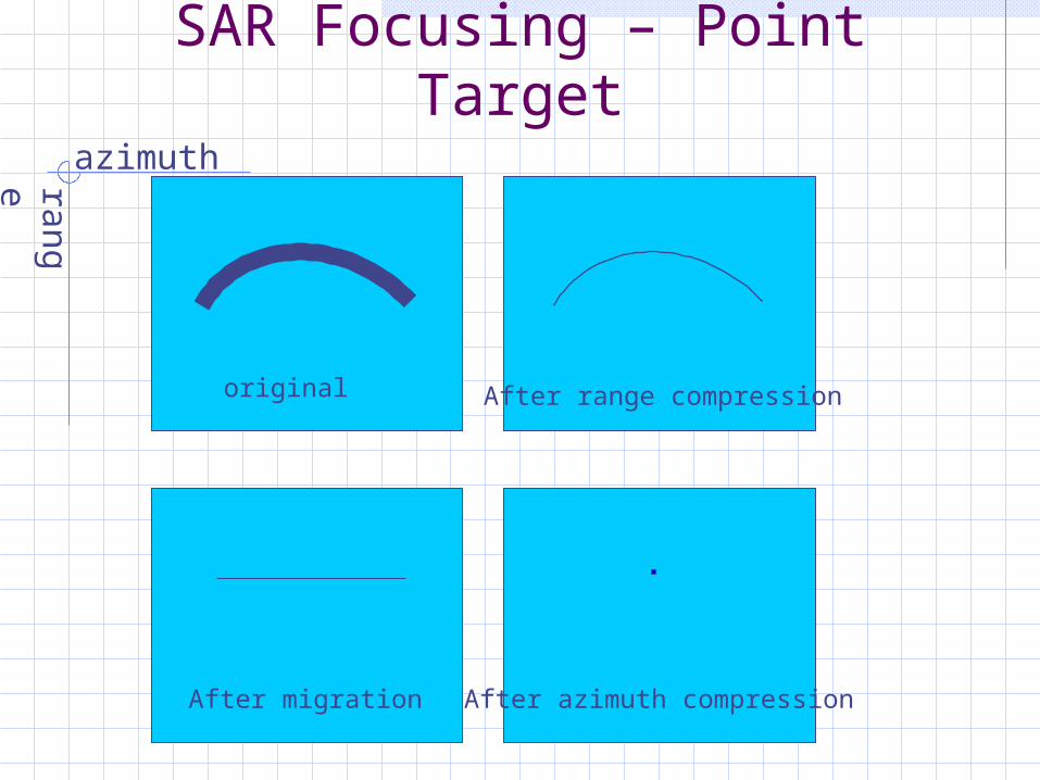
SAR Focusing – Point Target
range azimuth
original After range compression
After migration After azimuth compression
Synthetic Aperture Radar – Systems and Signal Processing
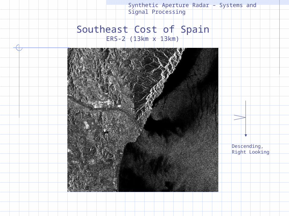
Southeast Cost of SpainERS-2 (13km x 13km)
Descending,Right Looking
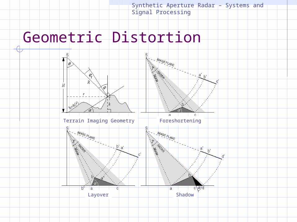
Geometric Distortion
Synthetic Aperture Radar – Systems and Signal Processing
Terrain Imaging Geometry Foreshortening
Layover Shadow
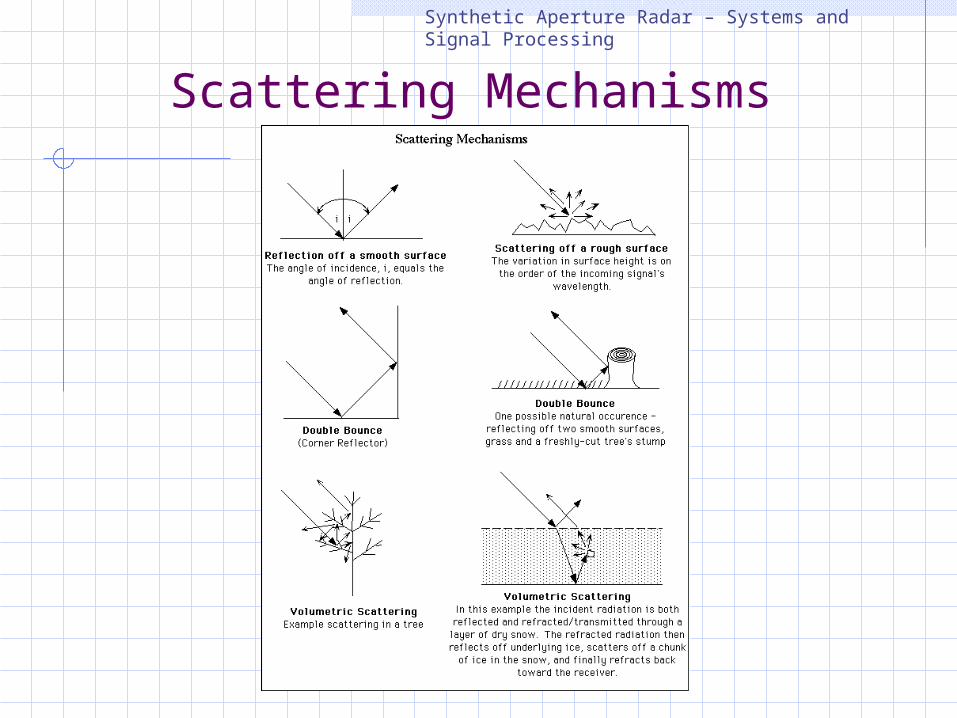
Scattering MechanismsSynthetic Aperture Radar – Systems and Signal Processing
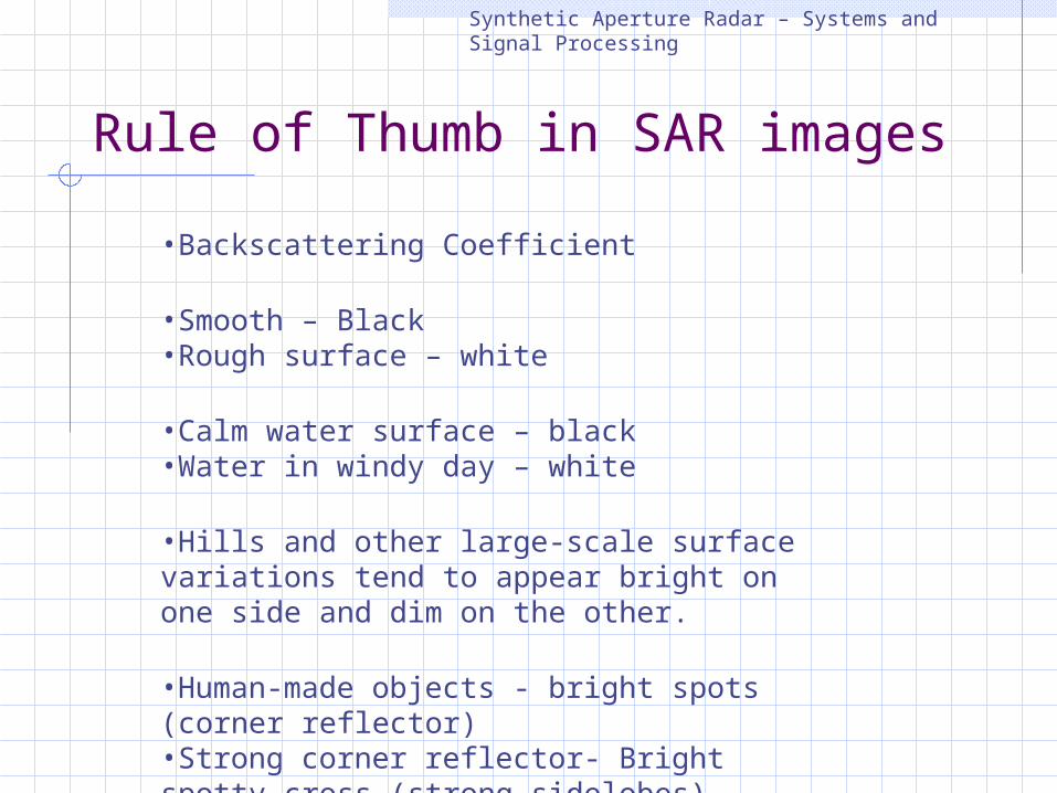
Rule of Thumb in SAR images
Synthetic Aperture Radar – Systems and Signal Processing
•Backscattering Coefficient
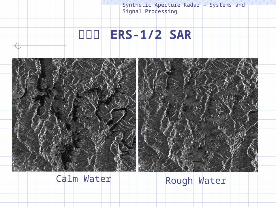
•Smooth – Black •Rough surface – white
•Calm water surface – black•Water in windy day – white
•Hills and other large-scale surface variations tend to appear bright on one side and dim on the other.
•Human-made objects - bright spots (corner reflector) •Strong corner reflector- Bright spotty cross (strong sidelobes)
Synthetic Aperture Radar – Systems and Signal Processing
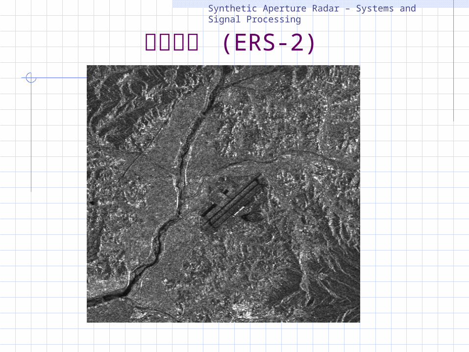
청주공항 (ERS-2)
Synthetic Aperture Radar – Systems and Signal Processing
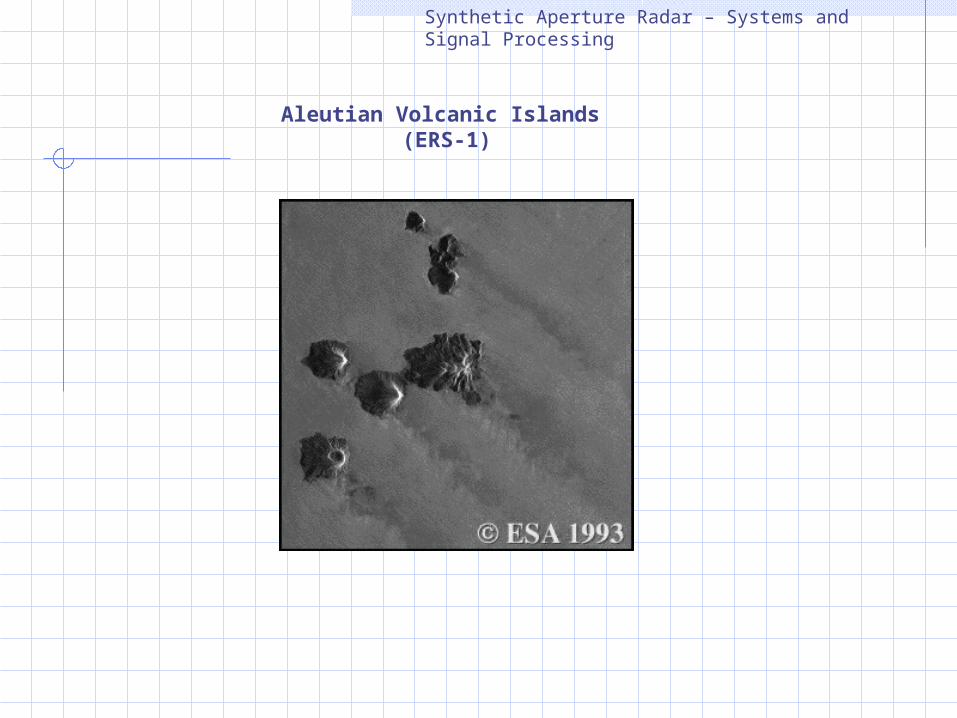
Aleutian Volcanic Islands (ERS-1)
Synthetic Aperture Radar – Systems and Signal Processing
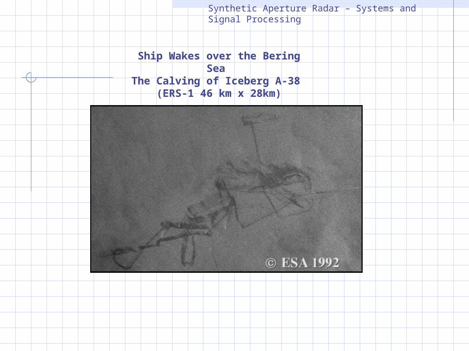
Ship Wakes over the Bering Sea The Calving of Iceberg A-38
(ERS-1 46 km x 28km)
Synthetic Aperture Radar – Systems and Signal Processing
대청호 ERS-1/2 SAR
Calm Water Rough Water
Synthetic Aperture Radar – Systems and Signal Processing
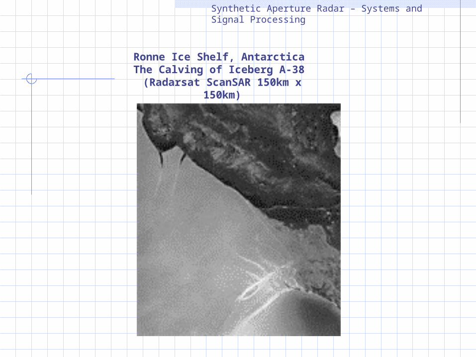
Ronne Ice Shelf, Antarctica The Calving of Iceberg A-38
(Radarsat ScanSAR 150km x 150km)
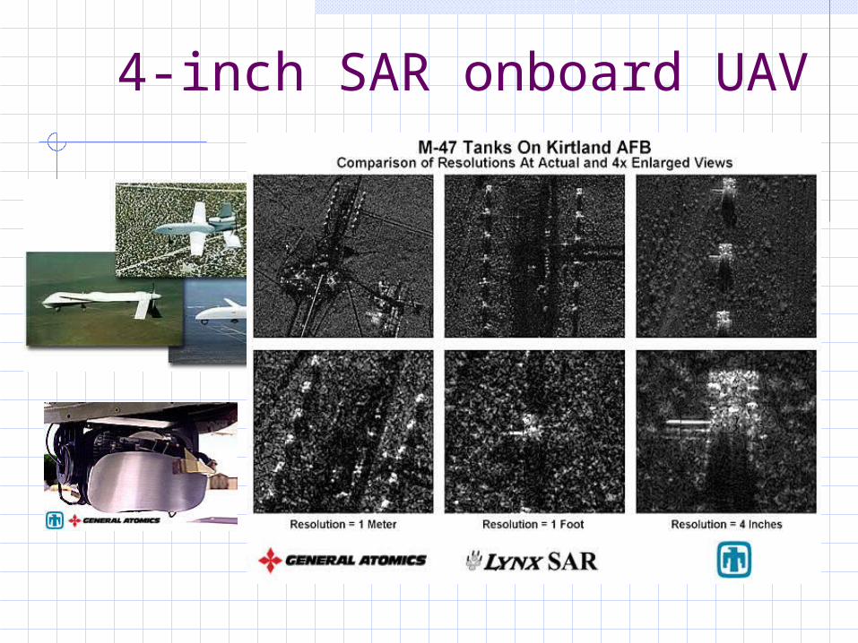
4-inch SAR onboard UAV
Synthetic Aperture Radar – Systems and Signal Processing
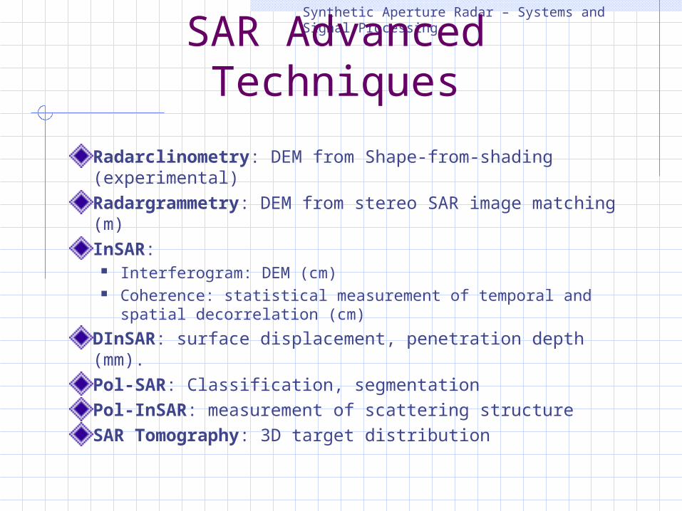
SAR Advanced TechniquesRadarclinometry: DEM from Shape-from-shading (experimental)Radargrammetry: DEM from stereo SAR image matching (m)InSAR:
Interferogram: DEM (cm) Coherence: statistical measurement of temporal and spatial
decorrelation (cm)DInSAR: surface displacement, penetration depth (mm). Pol-SAR: Classification, segmentationPol-InSAR: measurement of scattering structureSAR Tomography: 3D target distribution
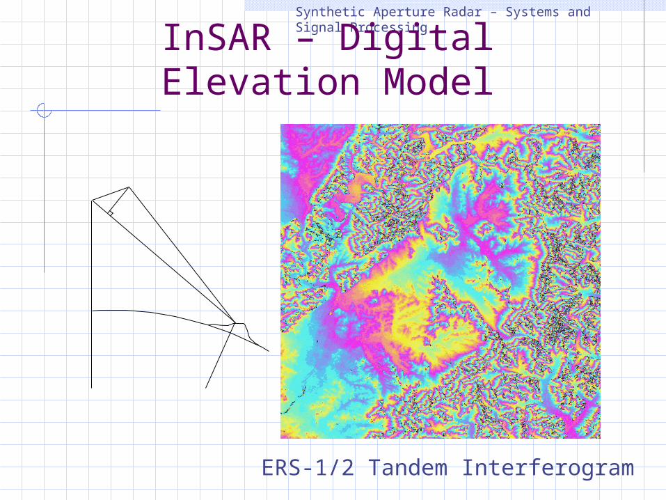
Synthetic Aperture Radar – Systems and Signal ProcessingInSAR – Digital Elevation
Model
ERS-1/2 Tandem Interferogram
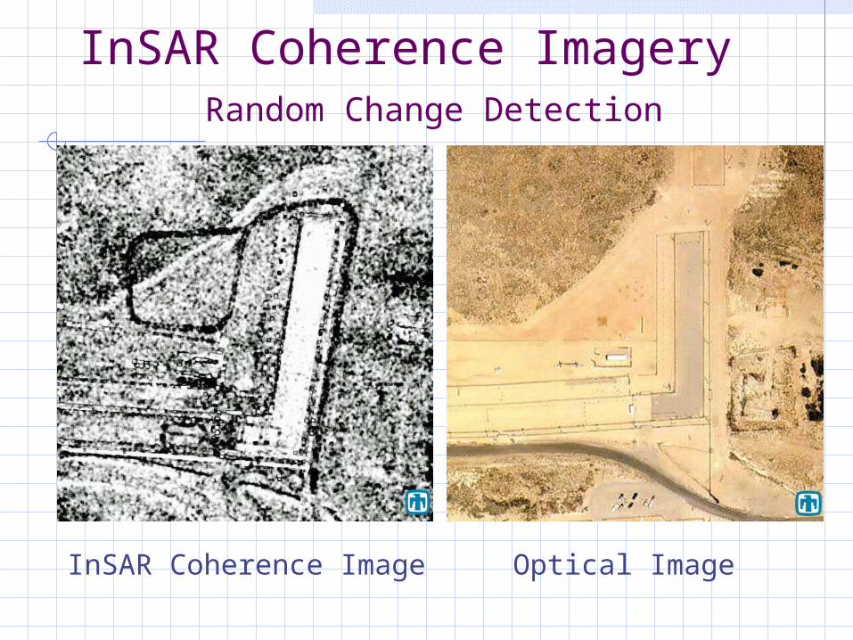
InSAR Coherence Imagery Random Change Detection
InSAR Coherence Image Optical Image
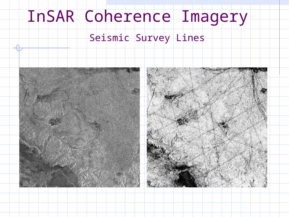
InSAR Coherence Imagery Seismic Survey Lines
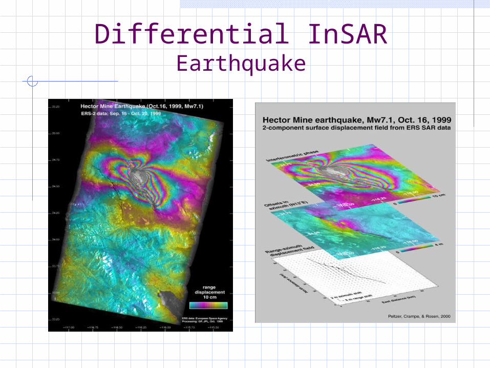
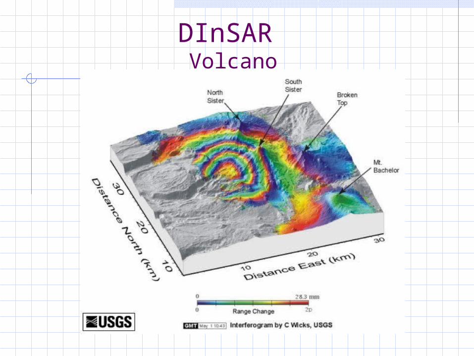
Differential InSAREarthquake
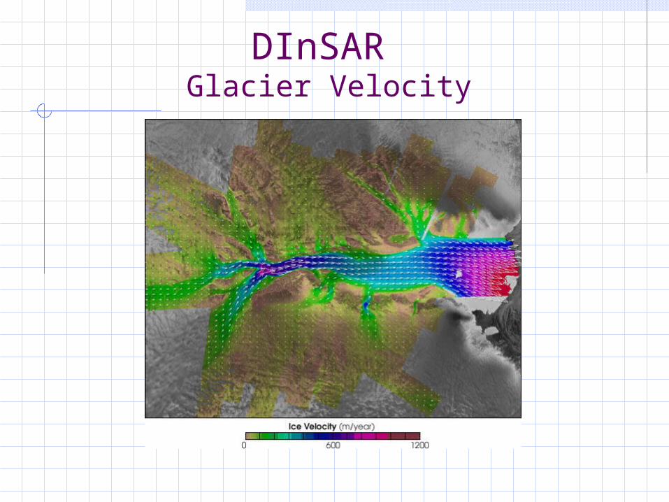
DInSAR Glacier Velocity

DInSAR Land Subsidence
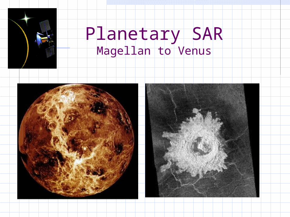
Planetary SARMagellan to Venus
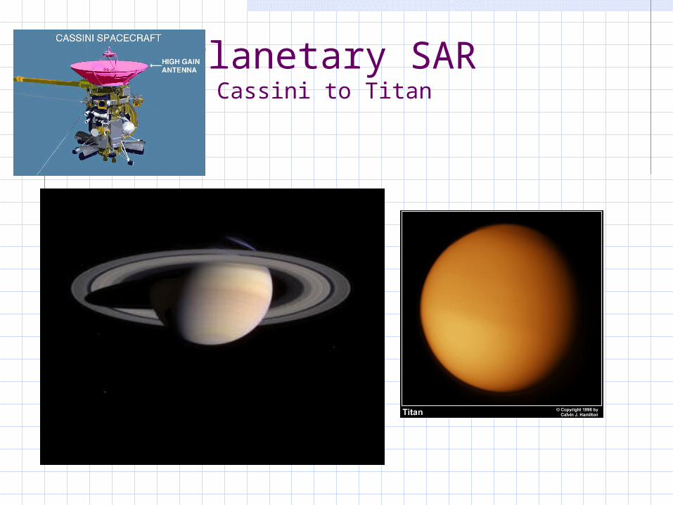
Planetary SARCassini to Titan
Synthetic Aperture Radar – Systems and Signal Processing
SAR Applications for Peace reconnaissance, survelliance and targetting target detection and recognition moving target detection navigation and guidence
- Sandia National Lab. 4-inch SAR
Synthetic Aperture Radar – Systems and Signal Processing
SAR Peaceful Applications
Cartography – DEM, DTM Geology – Geological Mapping Seismology – Co-seismic displacement field Volcanology – Prediction of volcano eruption Forestry – Forest classification, deforest monitoring Soil Science – Soil moisture Glaciology – Glacier motion Oceanography – Ocean wave, wind, circulation, bathymetry Agriculture – Crop monitoring Hydrology – Wetland assessment Environment – Oil spill, hazard monitoring Archaeology – Sub-surface mapping
Synthetic Aperture Radar – Systems and Signal Processing
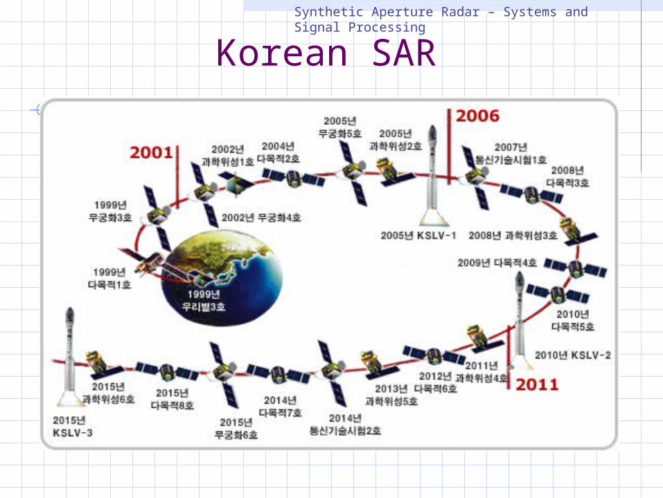
Korean SAR