Embed Size (px)
Citation preview
Kandungan
Muka Surat
DARI MEJA PENGARANG 1
SEMINAR TAHUNAN KEJURUTERAANGEOINFORMASI 2
MALAYSIAN ACTIVE GPS SYSTEM(MASS) PROJECT 3 - 5
GLOBAL MAPPING FORUM 2000 6 - 8
CALENDAR OF EVENTS 8 - 9
INSTITUTIONAL ISSUES FOR GISIMPLEMENTATION : SABAH’SEXPERIENCE 10 - 16
SENARAI PENERBITAN BERKAITAN
SISTEM MAKLUMAT GEOGRAFI 17
NOTA:Kandungan yang tersiar boleh diterbitkan semula denganizin Urusetia Jawatankuasa Pemetaan dan Data SpatialNegara
Sidang PengarangPenaung
Dato’ Hamid bin Ali,DIMP, KMN, PMC, PJC
Ketua Pengarah Ukur dan PemetaanMalaysia
Penasihat Muhamed Kamil bin Mat Daud, KMN
Ketua EditorCheong Kwok Wai
EditorKamariah binti Jaafar
Abdul Manan bin AbdullahAbdul Hadi bin Abdul Samad
Amran bin Abu Rashid
Ketua RekabentukIsmail bin Mohd Yusof, KSD
Ketua PencetakMuhammat Puzi bin Ahmat
MAKLUMANBuletin GIS diterbitkan dua (2) kali setahunoleh Jawatankuasa Pemetaan dan DataSpatial Negara. Sidang pengarang amatmengalu-alukan sumbangan berbentuk artikel danlaporan bergambar mengenai perkembanganSistem Maklumat Geografi di Agensi Kerajaan,Badan Berkanun dan Institut Pengajian Tinggi.Segala pertanyaan dan sumbangan bolehdikemukakan kepada :
Ketua EditorBuletin GISBahagian Pengeluaran PemetaanJabatan Ukur dan Pemetaan MalaysiaTingkat 3, Bangunan UkurJalan Semarak50578 Kuala Lumpur.
JAWATANKUASA PEMETAAN DAN DATA SPATIAL NEGARA
1. Jabatan Ukur dan Pemetaan Malaysia(JUPEM)
2. Jabatan Tanah dan Ukur Sabah3. Jabatan Tanah dan Survei Sarawak4. Wakil Kementerian Pertahanan5. Jabatan Mineral dan Geosains Malaysia6. Jabatan Perhutanan Semenanjung
Malaysia7. Jabatan Pertanian Semenanjung
Malaysia8. Jabatan Perhutanan Sabah9. Jabatan Perhutanan Sarawak
10. Jabatan Pertanian Sabah11. Jabatan Pertanian Sarawak12. Pusat Remote Sensing Negara13. Universiti Teknologi Malaysia14. Universiti Teknologi MARA (co- opted)15. Universiti Sains Malaysia (co- opted)16. Jabatan Laut Sarawak (co- opted)
BULETIN GIS 1
Dari Meja Pengarang
Dunia sekarang berada di dalam erateknologi maklumat yang sedangberkembang dengan pesatnya.
Memandangkan Sistem Maklumat Geografi(GIS) merupakan cabang daripada teknologimaklumat, ianya perlu dimanfaatkansepenuhnya oleh manusia.
Kita lihat kini bahawa impak GIS semakin meluasdalam semua bidang yang menggunakanmaklumat geospatial misalnya dalampengurusan sumber, perancangan gunatanahdan beberapa lagi aplikasi geosains.
Sehubungan dengan ini, keluaran buletin padakali ini cuba menampilkan pengalaman JabatanTanah dan Ukur Sabah di dalammengimplimentasikan GIS di jabatannya.Prestasi sesebuah organisasi dalammenjalankan aktiviti dan meningkatkan kelebihandayasaingnya daripada orang lain akanditentukan oleh keberkesanan dan kecekapansistem pengurusan maklumat dalam organisasitersebut. Oleh yang demikian, tidak hairanlahmengapa pihak Jabatan Tanah dan Ukur Sabahtelah berusaha ke arah pengimplimentasianGIS. Keluaran kali ini turut memuatkan laporanterkini mengenai perkembangan ‘MalaysianActive GPS System (MASS)’ yang telahdibangunkan semenjak tahun 1998.Selaindaripada itu, laporan mengenai beberapaseminar yang berkaitan GIS yang telah diadakan
Ketua EditorBuletin GIS
di sepanjang tahun 2000 turut disertakantermasuk maklumat seminar ataupunpersidangan yang akan diadakan di sepanjangtahun 2001 sama ada di dalam atau di luarnegeri. Sebagai rujukan pembaca, disenaraikanjuga buku-buku berkaitan GIS yang terdapat diPerpustakaan Universiti Malaya.
Memandangkan minat yang mendalam yangtelah ditunjukkan oleh pelbagai pihak terhadapteknologi GIS, ianya merupakan faktorpendorong kepada pihak sidang pengaranguntuk meneruskan usaha dalam menyebarkandan mengumpul maklumat khusus berkaitanGIS. Sokongan yang padu daripada penggunamaklumat GIS dalam memberikan maklumbalas terutamanya yang berkaitanpengimplementasian GIS di agensi masing-masing amat dihargai.
Di sini pihak sidang pengarang ingin menyeruagar mana-mana pihak sama ada agensikerajaan atau swasta dan para akademik tampilmenyumbangkan hasil karya, laporanpenyelidekan dan sebagainya yang berkaitansistem maklumat geografi. Semua sumbangantersebut hendaklah dihantar kepada KetuaEditor, Buletin GIS sama ada secarabersurat atau e-mail kepada,Ketua Editor,[email protected].
Sekian.
BULETIN GIS 2
Bertempat di IDEAL Conference Center,Universiti Putra Malaysia (UPM), Serdang,Selangor, pada 6 dan 7 November 2000 yang
lalu telah berlangsung Seminar TahunanKejuruteraan Geoinformasi. Seminar ini merupakankali ke 4 diadakan dan merupakan anjuran bersamaInstitusi Pengajian Tinggi Awam dan Seksyen UkurTanah, Institut Jurukur Malaysia. Pada seminar kaliini, UPM telah diberi mandat untuk menjadi tuanrumah.
Seminar ini telah dirasmikan oleh Y.B. Tan Sri DatukKasitah Gaddam, Menteri Tanah dan PembangunanKoperasi Malaysia
Melalui seminar ini, golongan professional yangterdiri daripada para ‘practitioner’ serta akademikyang bergiat cergas dan aktif dalam disiplingeoinfomasi dan geoinformatik telah berjayadikumpulkan bagi mewujudkan satu forum ke arahperkongsian maklumat ukur, pemetaan, sistemmaklumat geografi dan sistem maklumat tanah.Seminar ini telah mendapat sambutan penyertaanyang menggalakkan baik sebagai peserta mahupunsebagai pembentang kertas kerja.
Sebanyak lebih daripada 60 kertas kerja yangmerupakan projek cadangan, projek dalamperlaksanaan dan hasil penyelidekan telah berjayadibentangkan yang mana skopnya meliputi bidanggeoinformasi dan geoinformatik.
Secara keseluruhannya, seminar ini telah berjayamencapai matlamatnya dalam menyebarkanmaklumat dan menampilkan isu-isu terkini dankemajuan dalam bidang geoinformasi dangeoinformatik.
Berikut adalah diantara kertaskerja yang telahdibentangkan pada seminar berkenaan:
1. ISO Certification for the GIS: will it ensurequality byNordin Ahmad,Geoinfo ServicesSdn. Bhd.
2. Pembangunan Pakej Pengajaran GISMenggunakan Teknologi Multimedia olehMohd. Fikri Ismail dan Ghazali desa, UTM
3. Pembangunan Aplikasi SistemMaklumat Geografi (GIS) UntukPengurusan Masjid (GISmas) olehMasiri Kaamin dan Norkhair Ibrahim, UTM
SEMINAR TAHUNAN KEJURUTERAANGEOINFORMASI
4. Managing River Landscape With GIS byNurul Salmi Abdul Latip, USM
5. Pemetaan Berasaskan Web: satupendekatan internet di dalam SistemMaklumat Geografi oleh Eran SadekSaid md Sadek dan Wan Mohd. Naim WanMohd, UTM
6. Pembangunan GIS Untuk Pengurusan,Pengawalan dan Pencegahan PenyakitMalaria oleh Zulkepli Majid dan RazaliTompang, UTM
7. Why is 3D GIS Difficult to Realize byAlias Abdul Rahman and JaneDrummond, UTM
8. Preparation of Flood Hazard Risk Map :GIS and remote sensing Approach byRahayaMamat, Shattri Mansor,AbdulRashid Mohamed Shariff, Ahmad RodziMahmud dan Abd. Halim Ghazali
9. Geographical Information System (GIS)and remote Sensing in LandslidePrediction by Sharifah Nazatul ShimaSyed Omar, Shattri Mansor, Husaini Omar,Abdul Rashid Mohamed Shariff dan AhmadRodzi Mahmud
10. Processing Planning Applications ByGeographical Information System (GIS)by Abbas Abdul Wahab, Jabatan PerancangBandar dan DesaandShattri Mansor, NordinAhmad and AbdulRashid Mohamed Shariff,UPM
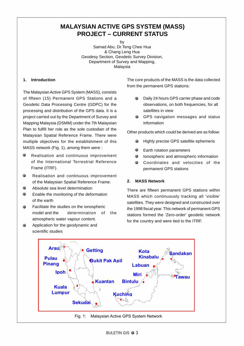
Fig. 1: Malaysian Active GPS System Network
MALAYSIAN ACTIVE GPS SYSTEM (MASS)PROJECT – CURRENT STATUS
bySamad Abu, Dr.Teng Chee Hua
& Chang Leng HuaGeodesy Section, Geodetic Survey Division,
Department of Survey and Mapping,Malaysia
1. Introduction
The Malaysian Active GPS System (MASS), consists
of fifteen (15) Permanent GPS Stations and a
Geodetic Data Processing Centre (GDPC) for the
processing and distribution of the GPS data. It is a
project carried out by the Department of Survey and
Mapping Malaysia (DSMM) under the 7th Malaysian
Plan to fulfill her role as the sole custodian of the
Malaysian Spatial Reference Frame. There were
multiple objectives for the establishment of this
MASS network (Fig. 1), among them were :
Realisation and continuous improvement
of the International Terrestrial Reference
Frame (ITRF).
Realisation and continuous improvement
of the Malaysian Spatial Reference Frame.
Absolute sea level determination
Enable the monitoring of the deformation
of the earth
Facilitate the studies on the ionospheric
model and the determination of the
atmospheric water vapour content.
Application for the geodynamic and
scientific studies
The core products of the MASS is the data collected
from the permanent GPS stations:
Daily 24 hours GPS carrier phase and code
observations, on both frequencies, for all
satellites in view
GPS navigation messages and status
information
Other products which could be derived are as follow:
Highly precise GPS satellite ephemeris
Earth rotation parameters
Ionospheric and atmospheric information
Coordinates and velocities of the
permanent GPS stations
2. MASS Network
There are fifteen permanent GPS stations within
MASS which continuously tracking all ‘visible’
satellites. They were designed and constructed over
the 1998 fiscal year. This network of permanent GPS
stations formed the ‘Zero-order’ geodetic network
for the country and were tied to the ITRF.
Getting
PulauPinang
Arau
Bukit Pak Apil
Kuantan
Ipoh
Labuan
Miri
Bintulu
Kuching
KotaKinabalu
KualaLumpur
Tawau
Sandakan
Sekudai
BULETIN GIS 3
BULETIN GIS 4
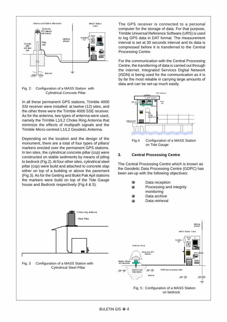
Fig. 2: Configuration of a MASS Station withCylindrical Concrete Pillar
In all these permanent GPS stations, Trimble 4000SSI receiver were installed at twelve (12) sites, andthe other three were the Trimble 4000 SSE receiver.As for the antenna, two types of antenna were used,namely the Trimble L1/L2 Choke Ring Antenna thatminimize the effects of multipath signals and theTrimble Micro-centred L1/L2 Geodetic Antenna.
Depending on the location and the design of themonument, there are a total of four types of pillars/markers erected over the permanent GPS stations.In ten sites, the cylindrical concrete pillar (ccp) wereconstructed on stable sediments by means of pilingto bedrock (Fig.2). At four other sites, cylindrical steelpillar (csp) were build and attached to concrete slapeither on top of a building or above the pavement(Fig.3). As for the Getting and Bukit Pak Apil stationsthe markers were build on top of the Tide Gaugehouse and Bedrock respectively (Fig.4 & 5).
Fig. 3 Configuration of a MASS Station withCylindrical Steel Pillar
Fig. 5 : Configuration of a MASS Stationon bedrock
Fig.4 Configuration of a MASS Stationon Tide Gauge
3. Central Processing Centre
The Central Processing Centre which is known asthe Geodetic Data Processing Centre (GDPC) hasbeen set-up with the following objectives:
Data receptionProcessing and integritymonitoringData archiveData retrieval
The GPS receiver is connected to a personalcomputer for the storage of data. For that purpose,Trimble Universal Reference Software (URS) is usedto log GPS data in DAT format. The measurementinterval is set at 30 seconds interval and its data iscompressed before it is transferred to the CentralProcessing Centre.
For the communication with the Central ProcessingCentre, the transferring of data is carried out throughthe internet. Integrated Services Digital Network(ISDN) is being used for the communication as it isby far the most reliable in carrying large amounts ofdata and can be set-up much easily.
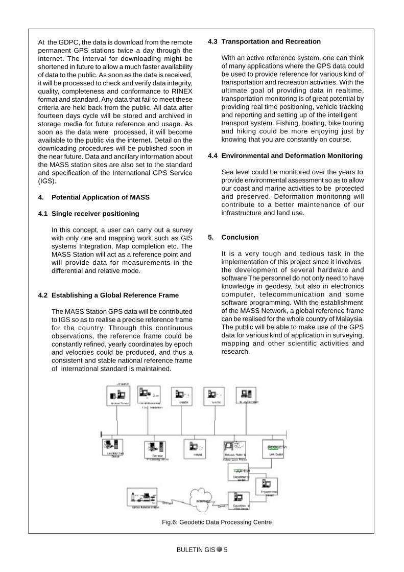
At the GDPC, the data is download from the remotepermanent GPS stations twice a day through theinternet. The interval for downloading might beshortened in future to allow a much faster availabilityof data to the public. As soon as the data is received,it will be processed to check and verify data integrity,quality, completeness and conformance to RINEXformat and standard. Any data that fail to meet thesecriteria are held back from the public. All data afterfourteen days cycle will be stored and archived instorage media for future reference and usage. Assoon as the data were processed, it will becomeavailable to the public via the internet. Detail on thedownloading procedures will be published soon inthe near future. Data and ancillary information aboutthe MASS station sites are also set to the standardand specification of the International GPS Service(IGS).
4. Potential Application of MASS
4.1 Single receiver positioning
In this concept, a user can carry out a surveywith only one and mapping work such as GISsystems Integration, Map completion etc. TheMASS Station will act as a reference point andwill provide data for measurements in thedifferential and relative mode.
4.2 Establishing a Global Reference Frame
The MASS Station GPS data will be contributedto IGS so as to realise a precise reference framefor the country. Through this continuousobservations, the reference frame could beconstantly refined, yearly coordinates by epochand velocities could be produced, and thus aconsistent and stable national reference frameof international standard is maintained.
4.3 Transportation and Recreation
With an active reference system, one can thinkof many applications where the GPS data couldbe used to provide reference for various kind oftransportation and recreation activities. With theultimate goal of providing data in realtime,transportation monitoring is of great potential byproviding real time positioning, vehicle trackingand reporting and setting up of the intelligenttransport system. Fishing, boating, bike touringand hiking could be more enjoying just byknowing that you are constantly on course.
4.4 Environmental and Deformation Monitoring
Sea level could be monitored over the years toprovide environmental assessment so as to allowour coast and marine activities to be protectedand preserved. Deformation monitoring willcontribute to a better maintenance of ourinfrastructure and land use.
5. Conclusion
It is a very tough and tedious task in theimplementation of this project since it involvesthe development of several hardware andsoftware The personnel do not only need to haveknowledge in geodesy, but also in electronicscomputer, telecommunication and somesoftware programming. With the establishmentof the MASS Network, a global reference framecan be realised for the whole country of Malaysia.The public will be able to make use of the GPSdata for various kind of application in surveying,mapping and other scientific activities andresearch.
Fig.6: Geodetic Data Processing Centre
BULETIN GIS 5
BULETIN GIS 6
The Global Mapping Forum 2000 was held atthe International Conference Center Hiroshimain Hiroshima City, Japan from 28 to 30
November 2000. The Forum which provided anexcellent opportunity for National MappingOrganizations (NMO) to exchange views andinformation on issues of mutual interest had attracteda total of 250 participants from 33 countries. ThePermanent Committee on GIS Infrastructure for Asiaand the Pacific (PCGIAP), a regional forum of NMOtook advantage of this Forum to hold its SeventhExecutive Board Meeting on 26 November 2000, twodays preceding the Global Mapping Forum. OnNovember 30 afternoon, after closing the Forum, ameeting for Working Group 3 on data policy was held.This Forum is the third of this kind following Gifu Cityin 1997 and Sioux Falls in 1998.
Professor John E. Estes, the President ofInternational Steering Committee of Global Mapping(ISCGM) declared open the Forum and the WelcomeAddress of Mr. Yuzan Fujita, the Governor ofHiroshima Prefecture was read. Dr. Jiro Kondo,Professor Emeritus of University of Tokyo and Dr.Tadatoshi Akiba, the Mayor of Hiroshima City bothdelivered keynote Addresses. Dr. Kondo reviewedthe history of Global Mapping initiative and stressedthe importance of global geographic data for globalenvironmental researches. The Mayor Akiba, on theother hand, introduced the history of Hiroshima. Hefurther stated the significance of this Forum beingheld in Hiroshima referring to the fact that life ofvegetation is a symbol of survival of Hiroshima andalso a symbol of global environment.
Background
In the early 1990’s, the Ministry of Construction ofJapan, recognizing the capability of computertechnology in data processing, planned to apply it toproduce three-dimensional cartographic informationand to develop global map as well. Consequently,the first international workshop of global map wasthen held at Izumo city in April, 1994 to discuss thefeasibility of the idea. A resolution was formed toproduce a global geographic information at a scaleof 1:1 000 000 which covers the land surface of the
earth with approximately 1km grids. The first GlobalMapping Meeting was subsequently held in Tsukubain February 1996. Among important matters workedout in this Conference was establishing theSecretariat of the International Steering Committeefor Global Mapping, electing Dr. John E. Estes,Director of Remote Sensing Research Unit,University of California as a chairperson, and settingup the Secretariat at the Geographical SurveyInstitute of Japan.
The level of participating countries are categorizedas follows:Level A: Besides producing its own country’s GlobalMap, a member country in this level also providesassistance to produce Global Map of Level C’scountry. The developed countries are in this level.Level B: A member country produces its own GlobalMap. The developing countries are in this level.Level C: A member country provides assistance toLevel A countries for preparation of Global Maps. Aselected number of developing countries and poorcountries are in this level.
It is recognized that the United Nations’ support iscrucial to enable successful participation andimplementation of the Global Mapping project. Witha letter of endorsement from the Director of StatisticsBureau of the United Nations, the ISCGM appealedto the national mapping organizations throughout theworld for the cooperation and participation in GlobalMapping Project. The needs for Global Mapping andits related projects were further discussed at theCambridge Conference in July 1999, with therepresentatives from 73 national mappingorganizations.
As of August 2, 1999, 70 countries were enrolled inthe ISCGM and approximately 60 % of the wholeland surface (91,330,000 km2) had been coveredwith global maps. When taking into account another35 countries that are presently considering joiningthe ISCGM, then a further 31,399,900 km2 will becovered with the Global Maps, in which caseapproximately 80% of the total global land surfacewill be covered with the Global Maps. As of December2000 25, 2000, eighty one countries/regions were
GLOBAL MAPPING FORUM 2000by
Abdul Hadi bin Abdul Samad,JUPEM WPKL
E- mail: hadi @ JUPEMKL.juwpkl. gov. my
enrolled in the ISCGM and another 35 countries/regions were considering joining the ISCGM. The 81countries are now in the process of developing GlobalMap of their countries.
Actors in Global Map comprise of three categories:
1. Data providers – The nationalmapping gencies.
2. Project management – The ISCGM and itsSecretariat.
3. Users – That may comprise the end-users as well as value-adders.
Paper Presentations
Fifty papers were presented in six oral sessions andone poster session. Besides Reports on thedevelopment of Global Mapping from membercountries, the topics of the Forum were more focusedon applications of global geographic datasets. Dr.Bambang Rudyanto presented one of the interestingpapers from the Asian Disaster Reduction Center(ADRC) on “Development of Internet GIS System andStandardization from Global Mapping”.
The improved reliability of disaster information fromsatellite image data due to the recent advanced imageprocessing technology, enables us to obtain variousdisaster information via remote sensing at anytimeand any place. However, a system immediatelycontributing to disaster management for disastermitigation, has not been of discussed. Much attentionhas been paid to technological breakthrough by thesatellite image data providers while those workingfor the disaster management have not been activelyexposed to or involved in this field. It is also hard touse disaster information from the satellite image foractual disaster management without overlaying it togeneral geographic data such as topography andnatural condition, and social situation includingpopulation, buildings and infrastructure. Furthermore,high cost and skills to be acquired for introducing GISapplication have discouraged utilization of disasterinformation via GIS.
To solve this problem, ADRC has developed VENTEN(Vehicle through Electric Network of disasTergEographic InformatioN). The background ofVENTEN development, its system and data to beprocessed are discussed, and the possibility ofutilizing VENTEN for disaster management isanalyzed in this paper.
Mr. Hisashi Mori from the Japanese InfrastructureDevelopment Institute presented a paper on “Studyof Advanced Technology for use of Global GeographicInformation System”. In order to establish themethods for applying the Global Map to the global
environmental issues, this study aims to develop thetechnology necessary for the policy making on rivercontrol, disaster counter measure and food securityusing GIS through combining social and naturalenvironmental data with the Global Map. The studyarea covers the whole Ganges river basin and itssurrounding enclose in a rectangle are extendingfrom 20-40 degrees in the northern latitude and 70-100 degrees in the eastern latitude. The areaincludes territory of India, Bangladesh, Nepal,Bhutan, Myanmar, Pakistan and Tibet/China mainly.In a paper “Information Technology and NaturalDisaster Management in India”, Dr. Alok Guptaoutlined the use of GIS to manage natural disasterin India, which is considered as the world’s mostdisaster prone country. It has witnessed devastatingnatural disasters like droughts, floods, cyclones,earthquakes, landslides and others.
Similarly, Mr. Shahidullah touched on the applicationof Global Map for flood forecasting and monitoringin Bangladesh. Bangladesh is a flood prone Countrywhere there is recurrence of flood, almost every year,which cause severe damages to the life andproperties. Main cause of flood is due to heavyonrush of water coming from the upper ripariancountries through major river systems of the region.Heavy rainfall within the country is also responsiblefor generating the flood runoff. The lowlandtopography of the country makes it highly vulnerableto flood disaster. He admitted that Bangladesh cannot take appropriate measure to mitigate thesufferings due to mainly non-availability of flood data.In his paper, an attempt has been made to describebriefly the use of global map for monitoring the flooddata.
In a paper “The Global Spatial Data InfrastructureInitiative and Global Map”, Mr. Derek Clarke, theGSDI Steering Committee Chairman stated that inmost of the developed countries, it is widely acknowl-edged that spatial information is part of the nationalinfrastructure. Developing countries are perhaps notas advanced with this but are starting to realize theimportance of spatial information for the develop-ment of their countries.
These national initiatives are going beyond just es-tablishing databases for specific projects but towardsharnessing the information resources of all gov-ernment departments and agencies. This new di-rection is geared to minimize duplication of effortand data between agencies. This requires nationalpolicies and infrastructures. There is no doubt thatspatial information at the national level should bethe priority of all countries.He also reiterated that many issues, such asatmospheric pollution, global warming and watercatchment management, do not know national
BULETIN GIS 7
BULETIN GIS 8
boundaries and transcend the national interest.These global issues require harmonious spatialinformation at the regional and global level. To makedecisions on global issues requires spatialinformation appropriate for these purposes. Hesuggested that this information must be shared andintegrated across national boundaries.
Global Map Version 1.0
The highlight of the Forum was a declaration ofrelease of the Global Map version 1.0. Japan whichhelped other countries like Laos, Nepal, Sri Lankaand Thailand have completed and officially releasedthe data from ISCGM’s new websitehttp://www.iscgm.org on 28 November 2001. Datacan be downloaded for non-commercial use. TheSecretariat of ISCGM was glad and relieved by themuch-awaited release of Global Map. Some issuesrelated to project planning and product specificationswere finally overcome.
Conclusion
Through the presentations of technical papers, it isobvious that many countries are very close tocompleting development of Global Mapping of theircountries following leading countries. It also becameclear that user societies have big expectations tothe Global Mapping data for regional developmentplanning, disaster mitigation,resources management and global environmentalresearches. It is also crucial that the requirementsof three actors be adequately satisfied to ensure thecontinuing success of Global Mapping development.
* Those interested to get the proceedings of GlobalMapping Forum 2000, please contact the writer
CALENDAR OF EVENTS************************
DATE EVENT SITE CONTACT
2-5 Feb ICORG 2000 – International Hyderabad, AP Prof.Dr.Murali Krishna Iyyanki2001 Conference on “Remote Sensing India F: +91-40-339-7648
and GIS/GPS” E: [email protected]
7-9 Feb 4th Annual International Conference New Delhi, Sanjay Kumar2001 and Exhibition onGeographic India P: +91-118-452-7044, 444-0831,
Information Science 4554335E: [email protected],E: [email protected]: Sanjay.Kumar@ gisdevelopment.org
12-14 Feb Asia Geospatial Teknologi Kuala Lampur, Dan Laney2001 Conference Malaysia P: +1-305-667-4705
F: +1-305-667-7840E: [email protected]
13-15 Feb OICC Conference on “GIS Cairo, Org. of Islamic Capitals & Cities2001 Application in Planning & Egypt P: +9662-6981-953
Sustainable Development” F: 6981-053E: [email protected]
19-22 Feb GIS 2001“Branching Out: Spatial Vancouver, Matt Ball2001 Technology Goes Mainstream Canada P: +1-303-544-0594
F: 544-0595E: [email protected]
8-9 Mar AM/FM/GIS Conference Hyderabad, P: +91-40-331-41412001 India F: 40-330-6770
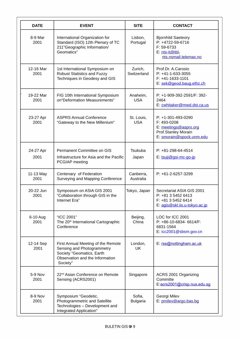
DATE EVENT SITE CONTACT
8-9 Mar International Organization for Lisbon, Bjornhild Saeteory2001 Standard (ISO) 12th Plenary of TC Portugal P: +4722-59-6716
211"Geographic Information/ F: 59-6733Geomatics” E: nts-it@tbl-
nts.nsmail.telemax.no
12-16 Mar 1st International Symposium on Zurich, Prof.Dr. A.Carosio2001 Robust Statistics and Fuzzy Switzerland P: +41-1-633-3055
Techniques in Geodesy and GIS F: +41-1633-1101E: [email protected]
` 19-22 Mar FIG 10th International Symposium Anaheim, P: +1-909-392-2591/F: 392-2001 on“Deformation Measurements” USA 2464
23-27 Apr ASPRS Annual Conference St. Louis, P: +1-301-493-02902001 “Gateway to the New Millenium” USA F: 493-0208
E: [email protected] MorainE: [email protected]
24-27 Apr Permanent Committee on GIS Tsukuba P: +81-298-64-4514
2001 Infrastructure for Asia and the Pacific Japan E: tsuji@gsi-mc-go-jpPCGIAP meeting
11-13 May Centenary of Federation Canberra, P: +61-2-6257-32992001 Surveying and Mapping Conference Australia
20-22 Jun Symposium on ASIA GIS 2001 Tokyo, Japan Secretariat ASIA GIS 20012001 ”Collaboration through GIS in the P: +81 3 5452 6413
Internet Era” F: +81 3 5452 6414E: [email protected]
6-10 Aug “ICC 2001” Beijing, LOC for ICC 20012001 The 20th International Cartographic China P: +86-10-6834- 6614/F:
Conference 6831-1564E: [email protected]
12-14 Sep First Annual Meeting of the Remote London, E: [email protected]
2001 Sensing and Photogrammetry UKSociety “Geomatics, EarthObservation and the Information Society”
5-9 Nov 22nd Asian Conference on Remote Singapore ACRS 2001 Organizing2001 Sensing (ACRS2001) Committe
8-9 Nov Symposium “Geodetic, Sofia, Georgi Milev2001 Photogrammetric and Satellite Bulgaria E: [email protected]
Technologies – Development andIntegrated Application”
BULETIN GIS 9
1. Objective of Paper
The last decade of the 20 Century has seen the
public sector of Malaysia soared in leaps and boundstowards office automation and computerisationwithin the government departments. In Sabah, thegovernment has responded promptly to the rapiddevelopment of Information Technology whereMaster Plans and committees have been put in placeto ensure cohesive advancement towards greaterdevelopment. This paper relates the Sabah’sexperience in bringing the agencies responsible forgeospatial data collection together in a collaborativemanner and systematic approach to addresspertinent issues related to geospatial data.
2. Rationale for Institutional Change
Prior to 1998, geospatial related data has beenmaintained by many agencies mainly to assist in theirrespective mapping activities with some form of GIS/CAD (Computer Aided Drawing) systems for datacollection.
Although there were already a number of committeesaddressing IT issues which at the same time coversfor GIS (where need arises), the needs for GIS wasnot properly addressed. There was a failure torecognise that GIS is by it self a specialised disciplinethat requires specific attention. With the samecommittees deployed for GIS activities resulted inusually more concerns hardware and softwarecomponents (system specifications). This approachfailed to address more important issues such asdata standards, overlapping responsibilities inmaintaining Framework Data which resulted in muchshort-comings in the State GIS implementationcontributed to:-
no suitable forum to discuss GISspecifically since members were not wellversed with the subject matter;
the efforts to address GIS implementationissues was ad-hoc and not continuous;
most committees were represented bythe same agencies and persons andhence probably non-efficient;
BULETIN GIS 10
INSTITUTIONAL ISSUES FOR GIS IMPLEMENTATION:SABAH’S EXPERIENCE
Secondly, the agencies in their respective GISimplementation have encountered similar institutionalissues impeding GIS inroads as follows:-
Cultural impediment is perhaps most seriouswhere the users community being at the driving
seat, needs an uplift to be at par with technologyevolution. Most often than not, the old mindsetstill accepted data, reports and the like, inhardcopy format instead of digital;
Prepared by:Doria Tan Yun Tying
Jabatan Tanah dan Ukur Sabah
there were too much time involved by mappingagencies to attend different meetings coveringsimilar subject and no-GIS related;
there was no correlation nor collaborationbetween committees:
lack of control to curb duplicating efforts on GISdata acquissition;
The institutional change was brought about by:Firstly, the framework policies adopted by both Stateand Federal Govenments; and secondly therealisation by GIS doers that there should beconsolidated efforts and to incept a high level comitteeto drive optimum results in GIS activities.
Firstly, the prominent documentation ( both have beenadopted by the State Government in 1997 as theframework police for public sector) and eventstowards realising this goal are as follows:-
th
Paragraph 18 calls creation for the ofa Jawatankuasa Penyelaras NaLISNegeri (JPNN) to oversee the developmentof Land Information Systems (LIS)within the public sector.
(Vol.1 Recommendation 18, pg.33)call for the creation of a state GIScommittee for “closer coorperationAnd coordination”
(Vol. 1 Recommendation 18. Pg.36)identifies “to facilitate the reinventionof the government through strategicdeployment of information andmultimediatechnologies”. This has resulted inamongothers, the formation of the Sabah ITCouncil and a Science and Technology Unit whoproposed, among others, that public datashould be organised underfour data hubs,
Jan 1997 PekelilingKemajuan
PentadbiranAwam(PKPA) 1/97
mid- 1997 State Public Sector
InformationTechnologyMaster Plan 1
(ITMP)
Human Resources in GIS and training needs isfundamental but yet very much lacking largelydue to lack of awareness at certain level. In thecurrent state of matter, most GIS personnelon-the-job, such as SystemAdministrator arewithout formal IT background;
Data Custodianship is guarded with much careand the sharing of digital data is kept to theminimal ;
Data Standard for GIS was not defined andwhere cross-agency data sharing do occur,it isfound that spatial data cannot be easily used byother GIS platform;
Insufficient exposure to the latest development and breakthrough in GIS;
Existing committees are more often than not,emphasised on hardware and softwarespecifications of a particular GIS project but lesson technicality issues like data category, featurecoding, compatibility, etc.
Unparalleled development and progress amongthe agencies has created ‘holes’ in the StateGeographic Data Model. Some datasets areprobably either incomplete or not suitable to otherUsers. Data sharing is also made complicatedand inter-agency dataset normalisation difficult.
Perhaps among the relevant stand point, it is the spinoffs from an incredible explosion in information tech-nology advancement which has dawn on a new erawhere:-
Electronic Government System, IT departmentsbecame the in-thing.
User expectation is more sophisticated so muchas that the public sector needs consistentupgrading.
Demand for better quality product;
The new luxury of internet allow users’ fingertipaccess to all information;
It was envisaged that a streamlined institutionframework with correlation between and among thedisciplines would serve as a suitable platform to chartoverall capacity building of geospatial Systems in theState and to address issues cohesively in anintegrated manner.
On the development of a State Framework DataModel and Data Standards for spatial features,Sabah; via Lands and Surveys Department in its
capacity as the NaLIS (Sabah) Secretariat, ispursuing these subjects via the National institutionsunder NaLIS. For this, ten (10) departments fromSabah; (inclusive of 2 Federal departments) haveparticipated in the derivation of the MalaysianFramework Data model and Data Standards.
3. Background of SGDC
Sabah Geographic Data Coordination WorkingCommittee, in short SGDC, has its roots in the StateRemote Sensing Committee (SRSC). SRSC was inexistence from 1990 formed by the State InvestmentCommittee (SIC) and has played active roles incoordinating remote sensing projects statewide.
In line with the rapid development of IT and theadoption of the two documentation, the Secretary ofNatural Resources (as chairman of SRSC) hasproposed to the lands and surveys Department(Secretariat of SRC) September 1997, to study andpropose how SRSC can participate and functionunder the newly setup SITC institutional framework.
4. The Rationale for a New committee
The inception of a new committee was proposed inline with NaLIS proposal for a JawatankuasaPenyelaras NaLIS Negeri (JPNN) and the setting upof a State GIS Committee contained in the Sabah ITMaster Plan with membership expanded from theSRSC while following the requirements of PKPA1/97.
It was further proposed that the new committee,SGDC would have dual function i.e. asJawatankuasa Penyelaras NaLIS Negeri (JPNN) dueto similarity in role and function. Hence SGDC fitsinto both the National framework
(NaLIS) and State framework (Sabah IT MasterPlan).
SGDC has provided the opportunity as the rightforum to discuss policies and GIS related issues asThe Working Committee on IT deployment in thePublic Sector under SITC cannot covers in detailssuch issues.
The role of SGDC encompasses all the issuesrelated to the use and management of digital spatialdata sets and its institutional implications. Themission of the committee is to provide the lead inthe efficient and effective management and use ofland information by:
BULETIN GIS 11
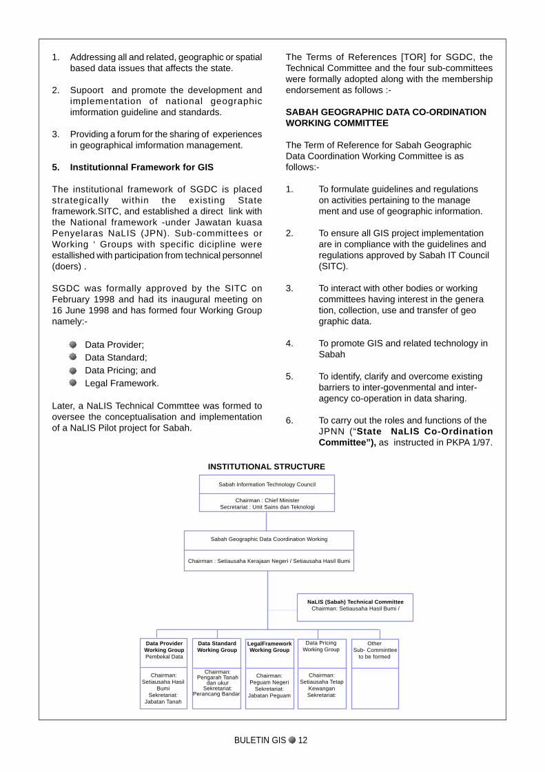
The Terms of References [TOR] for SGDC, theTechnical Committee and the four sub-committeeswere formally adopted along with the membershipendorsement as follows :-
SABAH GEOGRAPHIC DATA CO-ORDINATIONWORKING COMMITTEE
The Term of Reference for Sabah GeographicData Coordination Working Committee is asfollows:-
1. To formulate guidelines and regulationson activities pertaining to the management and use of geographic information.
2. To ensure all GIS project implementationare in compliance with the guidelines andregulations approved by Sabah IT Council(SITC).
3. To interact with other bodies or workingcommittees having interest in the generation, collection, use and transfer of geographic data.
4. To promote GIS and related technology inSabah
5. To identify, clarify and overcome existingbarriers to inter-govenmental and inter-agency co-operation in data sharing.
6. To carry out the roles and functions of theJPNN (“State NaLIS Co-OrdinationCommittee”), as instructed in PKPA 1/97.
1. Addressing all and related, geographic or spatialbased data issues that affects the state.
2. Supoort and promote the development andimplementation of national geographicimformation guideline and standards.
3. Providing a forum for the sharing of experiencesin geographical imformation management.
5. Institutionnal Framework for GIS
The institutional framework of SGDC is placedstrategically within the existing Stateframework.SITC, and established a direct link withthe National framework -under Jawatan kuasaPenyelaras NaLIS (JPN). Sub-committees orWorking ‘ Groups with specific dicipline wereestallished with participation from technical personnel(doers) .
SGDC was formally approved by the SITC onFebruary 1998 and had its inaugural meeting on16 June 1998 and has formed four Working Groupnamely:-
Data Provider;Data Standard;Data Pricing; andLegal Framework.
Later, a NaLIS Technical Commttee was formed tooversee the conceptualisation and implementationof a NaLIS Pilot project for Sabah.
BULETIN GIS 12
NaLIS (Sabah) Technical CommitteeChairman: Setiausaha Hasil Bumi /
INSTITUTIONAL STRUCTURE
Sabah Information Technology Council
Chairman : Chief MinisterSecretariat : Unit Sains dan Teknologi
Sabah Geographic Data Coordination Working
Chairman : Setiausaha Kerajaan Negeri / Setiausaha Hasil Bumi
Data ProviderWorking GroupPembekal Data
Data StandardWorking Group
LegalFrameworkWorking Group
Data PricingWorking Group
Other Sub- Comminttee
to be formed
Chairman:Peguam Negeri
Sekretariat:Jabatan Peguam
Chairman:Pengarah Tanah
dan ukurSekretariat:
Perancang Bandar
Chairman:Setiausaha Tetap
KewanganSekretariat:
Chairman:Setiausaha Hasil
BumiSekretariat:
Jabatan Tanah
BULETIN GIS 13
The participating membership of SGDC is a combi-nation of SRSC members and PKPA 1/97 require-ment as follows:-
1. Setiausaha Hasil Bumi {Chairman}
2. Pengarah Tanah dan Ukur {Secreteriat}
3. Pengarah Perhutanan
4. Pengarah Pertanian
5. Pengarah Perikanan
6. Pengarah Pembangunan EkonomiNegeri
7. Pengarah Kerja Raya
8. Pengarah Pengairan dan Saliran
9. Pengarah Perancang Bandar danWilayah
10. Pengarah Perkhidmatan KomputerNegeri
11. Peguam Besar Negeri
12. Pengarah Unit Sains danTeknologi
13. Setiausaha Tetap KementerianKewangan
14. Setiausaha Tetap KementerianPembangunanPerindustrian
15. Setiausaha Tetap KementerianPertanian dan Perikanan
16. Setiausaha Tetap PerkhidmatanSosial
17. Setiausaha Tetap KementerianKerajaan Tempatan danPerumahan
18. Setiausaha Tetap KementerianPerhubungan dan Kerja Raya
19. Setiausaha Tetap KementerianPelancongan Dan PembangunanAlam Sekitar
20. Bendahari Negeri, JabatanBendahari Negeri
NaLIS [SABAH] TECHNICAL COMMITTEE
The Term of Reference for JawatanKuasa Techni-cal NaLIS [Sabah} is as follows:-
To implement NaLISA (Sabah) in conformanceto NaLIS project criteria and supplemented withvision and strategy of SGDC and SITC.
To co-ordinate with Ministry of Land andCo-operative Development on procurement ofEquipment for NaLIS project.
To co-ordinate and overcome impediment tocollaborative activities among participatingAgencies.
To monitor the development of NaLISA (Sabah)version 1.0 to meet requirements of NaLISproject criteria and the strategy of SGDC andSITC.
The participating membership of the TechnicalCommittee is as follows:-
1. Setiausaha Hasil Bumi {Chairman}
2. Pengarah Tanah dan Ukur {Co-Chairman/Secretariat}
3. Majlis Perbandaran Kota Kinabalu
4. Pengarah Perhutanan
5. Pengarah Pertanian
6. Pengarah Kerja Raya
7. Pengarah Pengairan dan Saliran
8. Pengarah Perancang Bandar danWilayah
9. Pengarah Kajibumi
10. Pengarah Perangkaan
11. Pengarah Perikanan
12. Kementerian Tanah dan PembangunanKoperasi
13. Pasukan Projek NaLIS
14. Pengarah Perkhidmatan Komputer danNegeri {Co-opted}
15. Pengarah Sains dan Teknologi {Co-opted}
BULETIN GIS 14
DATA STANDARDS WORKING GROUP
The Term of Reference for Data StandardsWorking Group is as follows:-
To construct and maintain a common datadirectory, data standards and guideline forthe preparation of metadata for the Stateof Sabah.
To formulate guideline and regulation onthe use of a common data standards e.g.feature coding in GIS Systems.
To provide technical advisory services ondata standards as well as to assists in conforming to guideline and regulation ap
proved by the Central Committee.
To interact with other Working Groups inarea of common or overlapping jurisdiction pertaining to geographic data.
The participating membership of this WorkingGroup is as follows :-
1. Pengarah Tanah dan Ukur {Chairman}
2. Pengarah Perancangan Bandar danWilayah {Secretariat}
3. Pengarah Perhutanan
4. Pengarah Pertanian
5. Pengarah Perikanan
6. Pengarah Perkhidmatan Komputer Negeri
7. Pengarah Kerja Raya
8. Pengarah Pengairan dan Saliran
9. Pengarah Jabatan Air
10. Pengarah Unit Sains dan Teknologi
DATA PROVIDER WORKING GROUP
The Term of Reference for Data Provider WorkingGroup is as follows:-
To formulate guideline and regulation onjurisdiction in handling land and geographic based data as well as to identify,clarify and overcome barriers to data sharing.
To research and formulate guideline andregulation on use of spatial and non-spatial toolssuch as platform, format, etc.
To provide technical advisory services ongeographical data management as well asto assist in conforming to guideline andregulation approved by the CentralCommittee.
To inculcate skills and expertise in GIS andrelated technology.
To interact with other Working Groups inarea of common or overlapping jurisdictionpertaining to geographic data.
The participating membership of this WorkingGroup is as follows:-
1. Setiausaha Hasil Bumi {Chairman}
2. Pengarah Tanah dan Ukur {Secretariat}
3. Setiausaha Tetap Kementerian KerajaanTempatan dan Perumahan
4. Pengarah Perhutanan
5. Pengarah Pertanian
6. Pengarah Perikanan
7. Pengarah Perancang Ekonomi Negeri
8. Pengarah Yayasan Sabah
9. Pengarah Perancang Bandar dan Wilayah
10. Pengarah Penyiasatan Kajibumi
11. Pengarah Perkhidmatan Komputer Negeri
12. Pengarah Kerja Raya
13. Pengarah Jabatan Air
14. Pengarah Pengairan dan Saliran
15. Pengarah Taman-Taman Sabah
16. Pengarah Hidupan Liar
17. Pengarah Unit Sains dan Teknologi
18. Pengurus Besar Telekom MalaysiaBerhad
19. Pengurus Besar Lembaga Lektrik Sabah
BULETIN GIS 15
DATA PRICING SUB-COMMITTEE
The Term of Reference for Data Pricing WorkingGroup is as follows:-
1. To formulate guideline and regulation forbasis for data pricing computation.
2. To establish and maintain Data Pricing fordigital and hardcopy dataset for the state ofSabah.
3. To study cost-benefit and implications in theprocess of creation of wealth to the State ofSabah from geographic information.
4. To interact with other Working Groups inarea of common or overlapping jurisdictionpertaining to geographic data.
The participating membership of this WorkingGroup is as follows:-
1. Setiausaha Tetap KementerianKewangan {Chairman}
2. Bendahari Negeri, Jabatan Bendahari
Negeri {Secretariat}
3. Setausaha Hasil Bumi
4. Pengarah Perancangan Ekonomi Negeri
5. Pengarah Tanah Dan Ukur
6. Pengarah Perhutanan
7. Pengarah Pertanian
8. Pengarah Perikanan
9. Pengarah Pengairan Dan Saliran
10. Pengarah Perkhidmatan Komputer Negeri
11. Jabatan Peguam Besar Negeri
12. Pengarah Unit Sains Dan Teknologi
LEGAL FRAMEWORK SUB-COMMITTEE
The Term of Reference for Legal FrameworkWorking Group is as follows:-
1. To formulate policy and regulation pertainingto the transfer, use, keep and maintaininggeographical data.
2. To study and propose legislative needs toaddress the silence relating to transactionof geographic data for both digital andhardcopy format in the area of :
Copyright‘Illegal’ re-production of dataset of piracycyber security andother relevant issues
3. To effect regulatory measures and toprovide definition on :
Liability and accountability,Piracy andOther relevant issues relating to useableconstraint.
4. To interact with other Working Groups inarea of common or overlapping jurisdictionpertaining to geographic data.
The participating membership of this WorkingGroups is as follows:-
1. Peguam Besar Negeri {Chaiman}
2. Jabatan Peguam Besar Negeri{Secretariat}
3. Setiausaha Hasil Bumi
4. Pengarah Tanah Dan Ukur
5. Pengarah Perhutanan
6. Pengarah Pertanian
7. Pengarah Perikanan
8. Pengarah Perancangan EkonomiNegeri
9. Pengarah Unit Sains DanTeknologi
10. Sabah Law Association
6. NaLIS Implementation in Sabah
Through the active involvement of Lands andSurveys Department Sabah in the various NationalNaLIS Committees, the department has proposedto the SGDC for NaLIS implementation in Sabah inview of the impending benefits for the State sincethe objectives of NaLIS are in line with that of SGDC.The goals and objectives of adopting this pilot projectunder the SGDC framework includes:-
To develop an inventory [metadata] of alldevelopment data in the state;
To promote wider audience & usage ofgeospatial information overSabah.Net and Internet;
To develop a “single window” access to allData Providers and Data Users;
To integrate with State ElectronicGovernment Systems
BULETIN GIS 16
This point onwards, it is no longer just dataacquisition methodology or data currencymaintenance but rather who maintain what, use whatstandards and so on in mutual benefiting manner,ready for sharing. Then come issues in the ofintegrated data dictionary, access rights, systemsecurity and a host of others to be digested.
Overall, managing information from differentagencies covering the whole State of Sabah shallprove to be most challenging in the effort towardsachieving the Natural Resources Data Repository.
With the implementation of NaLIS [Sabah] pilotproject, the SGDC Institutional Framework put in-placed is timely to serve the GIS community in thestate better
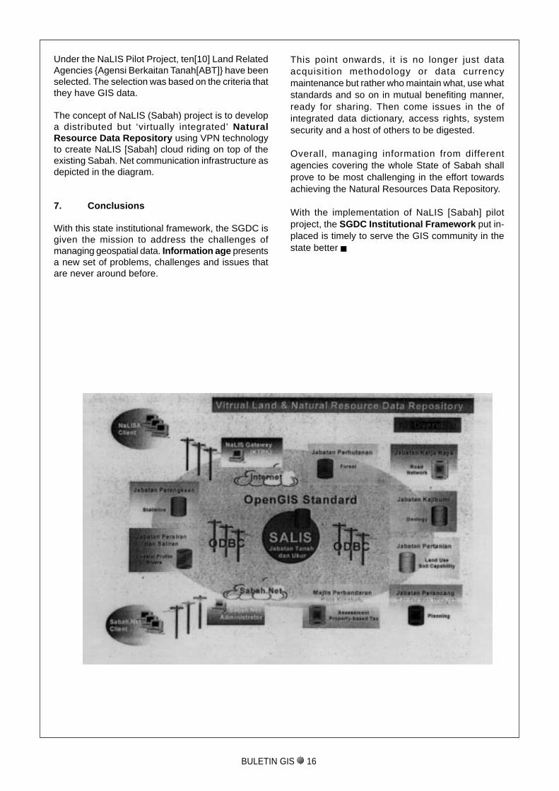
Under the NaLIS Pilot Project, ten[10] Land RelatedAgencies {Agensi Berkaitan Tanah[ABT]} have beenselected. The selection was based on the criteria thatthey have GIS data.
The concept of NaLIS (Sabah) project is to developa distributed but ‘virtually integrated’ NaturalResource Data Repository using VPN technologyto create NaLIS [Sabah] cloud riding on top of theexisting Sabah. Net communication infrastructure asdepicted in the diagram.
7. Conclusions
With this state institutional framework, the SGDC isgiven the mission to address the challenges ofmanaging geospatial data. Information age presentsa new set of problems, challenges and issues thatare never around before.
BULETIN GIS 17
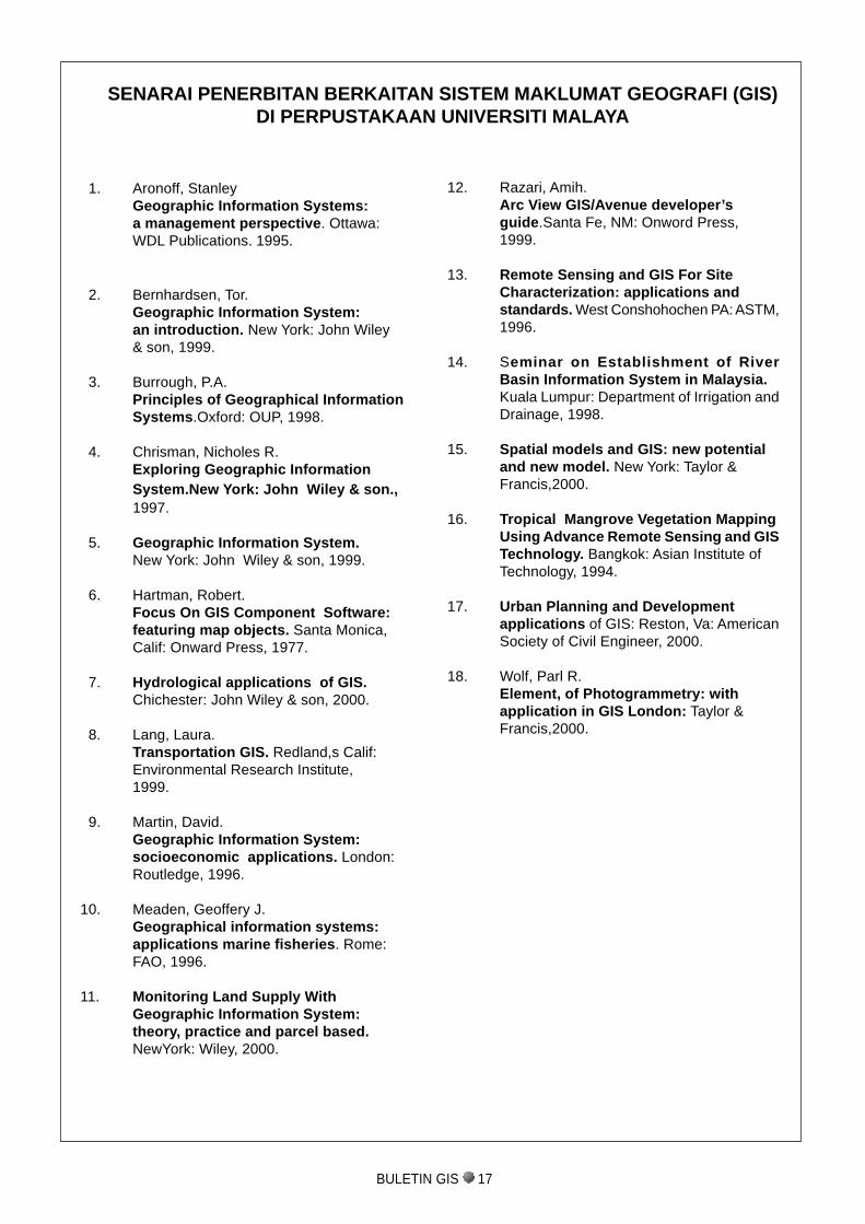
SENARAI PENERBITAN BERKAITAN SISTEM MAKLUMAT GEOGRAFI (GIS)DI PERPUSTAKAAN UNIVERSITI MALAYA
12. Razari, Amih.Arc View GIS/Avenue developer’sguide.Santa Fe, NM: Onword Press,1999.
13. Remote Sensing and GIS For SiteCharacterization: applications andstandards. West Conshohochen PA: ASTM,1996.
14. Seminar on Establishment of RiverBasin Information System in Malaysia.Kuala Lumpur: Department of Irrigation andDrainage, 1998.
15. Spatial models and GIS: new potentialand new model. New York: Taylor &Francis,2000.
16. Tropical Mangrove Vegetation MappingUsing Advance Remote Sensing and GISTechnology. Bangkok: Asian Institute ofTechnology, 1994.
17. Urban Planning and Developmentapplications of GIS: Reston, Va: AmericanSociety of Civil Engineer, 2000.
18. Wolf, Parl R.Element, of Photogrammetry: withapplication in GIS London: Taylor &Francis,2000.
1. Aronoff, StanleyGeographic Information Systems:a management perspective. Ottawa:WDL Publications. 1995.
2. Bernhardsen, Tor.Geographic Information System:an introduction. New York: John Wiley& son, 1999.
3. Burrough, P.A.Principles of Geographical InformationSystems.Oxford: OUP, 1998.
4. Chrisman, Nicholes R.Exploring Geographic InformationSystem.New York: John Wiley & son.,1997.
5. Geographic Information System.New York: John Wiley & son, 1999.
6. Hartman, Robert.Focus On GIS Component Software:featuring map objects. Santa Monica,Calif: Onward Press, 1977.
7. Hydrological applications of GIS.Chichester: John Wiley & son, 2000.
8. Lang, Laura.Transportation GIS. Redland,s Calif:Environmental Research Institute,1999.
9. Martin, David.Geographic Information System:socioeconomic applications. London:Routledge, 1996.
10. Meaden, Geoffery J.Geographical information systems:applications marine fisheries. Rome:FAO, 1996.
11. Monitoring Land Supply WithGeographic Information System:theory, practice and parcel based.NewYork: Wiley, 2000.

Disedia dan dicetak oleh JUPEM No.28-01


![Untitled-1 []"RISDA EFEKTIF PEKEBUN KECIL PRODUKTIF" "Komuniti Berdaya Desa Berjaya" ( DATO' MOHAMMAD Ketua Pengarah RISDA T BIN HASAN Timbalan Ketua Pengarah ( Pembangunan ) Timbalan](https://img.pdfslide.tips/doc/110x75/60a693f2c44c3e5f440c2286/untitled-1-risda-efektif-pekebun-kecil-produktif-komuniti.jpg)