Embed Size (px)
Citation preview

Hirofumi Hayashi Daisuke Yoshida, Daniel Kastl
Andrea Antonello, Franceschi Silvia
Geopaparazzi WORKSHOP


GEOPAPARAZZI: INTRO
Geopaparazzi is a tool for digital field mapping. Originally it has been developed for fast qualitaCve engineering/geologic surveys but it can be used also as a tool for emergency management, general field acCviCes and tourism. Geopaparazzi is available on the Android Market. Search for Geopaparazzi on your phone or get it from the online android market. Note: Geopaparazzi doesn't work on iPhone or other MacOS devices.
GEOPAPARAZZI: INTRO
The main aim of Geopaparazzi is to have a tool that: • can be always at hand when needed • gives the possibility to take georeferenced pictures during the survey, with further possibility to import them into a main GIS applicaCon
• is extremely easy to use and intuiCve, providing just few important funcConaliCes

GEOPAPARAZZI: INTRO
The main features available in Geopaparazzi are: • georeferenced notes: • text notes pictures sketches forms • GPS tracks logging a map view for browsing and navigaCon of the data easy export of collected data easy access to a base background data

GEOPAPARAZZI: INSTALLATION
1.connect your Android device to internet 2.open Play Store 3.type geopaparazzi within the Search textbox 4.select to install the first applicaCon found with the right name: Geopaparazzi 5.Open Geopaparazzi

GEOPAPARAZZI: START
Always be sure to have the GPS acCve or acCvate it while starCng the applicaCon

GEOPAPARAZZI: DASHBOARD

GEOPAPARAZZI: DASHBOARD
GPS status: RED: GPS is not switched on ORANGE: GPS is on but no fix was acquired GREEN: GPS is on, has fix, but is not logging BLUE: GPS is logging

GEOPAPARAZZI: DASHBOARD
Open the compass This opCon works only if the applicaCon GPS Status is installed on your device.

GEOPAPARAZZI: DASHBOARD
Open the informaCon box Which contains: • the acCve folder where the maps are stored • the name of the acCve background map (Map View) • the status of the GPS

GEOPAPARAZZI: DASHBOARD
Open the Main Menu important noCce: The exit buWon closes Geopaparazzi and stop any ongoing logging and sensor acCvity. This is the only way to properly close Geopaparazzi. Pushing the home buWon of the device will not close Geopaparazzi, which will conCnue any acCvity started.

GEOPAPARAZZI: DASHBOARD

GEOPAPARAZZI: SIMPLE NOTES Place a note in the GPS posiCon → available only when GPS signal is acCve. Notes can be: • text • pictures • sketches • forms

GEOPAPARAZZI: DASHBOARD

GEOPAPARAZZI: PROJECT INFO You can edit fields here and save.

GEOPAPARAZZI: DASHBOARD

GEOPAPARAZZI: DASHBOARD You can give the name you want to the log or accept the proposed one. This will be the name of the vector layer containing the GPS log.

GEOPAPARAZZI: DASHBOARD The icon of the logging changes when it is acCve. And also GPS status changes BLUE(GPS is logging).

GEOPAPARAZZI: DASHBOARD If you want to STOP logging then press logging icon and select to stop the process.

GEOPAPARAZZI: DASHBOARD

GEOPAPARAZZI: MAP VIEW First opening of MAP view. VisualizaCon of online maps with GPS posiCon. Tap this buWon one Cme.

GEOPAPARAZZI: MAP VIEW
The map menu: • Gps data list • SpaCalite data list • Toggle scalebar • Open compass • Enable center on GPS • Center on base map • Go to • Share posiCon • View in mixare • Import mapsforge data

GEOPAPARAZZI: MAP VIEW Keep this buWon tapped for a while...

GEOPAPARAZZI: MAP VIEW The map tools
Zoom tools
Manage notes
Manage bookmarks
Measure distances
Center map on current GPS posiCon

GEOPAPARAZZI: MANAGE NOTES Place a note in the GPS posiCon or in the center of the map (red cross). * Important for seWng note posiCon Notes can be: • text • pictures • sketches • forms

GEOPAPARAZZI: DASHBOARD

GEOPAPARAZZI: IMPORT Choose the format of the data to IMPORT, they can be vector or background data.

GEOPAPARAZZI: DASHBOARD

GEOPAPARAZZI: EXPORT Choose the format of the data to data to EXPORT.

STAGE: INSTALLATION
• Copy the zip file in a folder – stage_0.7_win64.zip for Windows PC 64 bits
– stage_0.7_win32.zip for Windows PC 32 bits
– stage_0.7_lin64.tar.gz for Linux PC 64 bits • Unzip the file in the proposed folder – stage_0.7_win64.zip
• Enter the unzipped folder • Run Stage applicaCon – stage.exe
hWps://github.com/moovida/STAGE/releases

STAGE: INSTALLATION Double click to maximize the window

STAGE: MOBILE Select the Mobile package and click on the triangle before the name.

STAGE: MOBILE Select the module you want to run. In this Cme, chose “GeopaparazziMapsCreator” for making your original spaCal data.

STAGE: MOBILE Fill in the blanks with the data you want to use as background of your map.
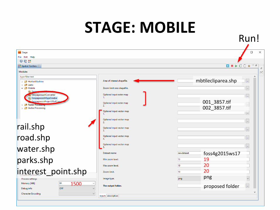
STAGE: MOBILE
rail.shp road.shp water.shp parks.shp interest_point.shp
Run!
mbClecliparea.shp
foss4g2015ws17 19 20 20 png
proposed folder
001_3857.Cf 002_3857.Cf
1500

MBTiles: Create on QGIS
• Run QGIS • Copy “QTiles” Plug-‐in from workshop material( patch modules
included)
• Open project “ws17mapmake.qgs”
• Set QTiles parameters
• Run QTiles process • Import mbCles on your Android device

MBTiles: Create on QGIS
Open Plugin Manager

MBTiles: Create on QGIS Search “qCles” from All
QTiles 1.4.5 dose not support Geopaparazzi4 MBTiles Copy Modified patch modules “QTiles” from Workshop material directory to QGIS plugin directory [1] /osgeo4w/apps/qgis/python/plugins [2] /Users/<yourname>/.qgis2/python/plugins
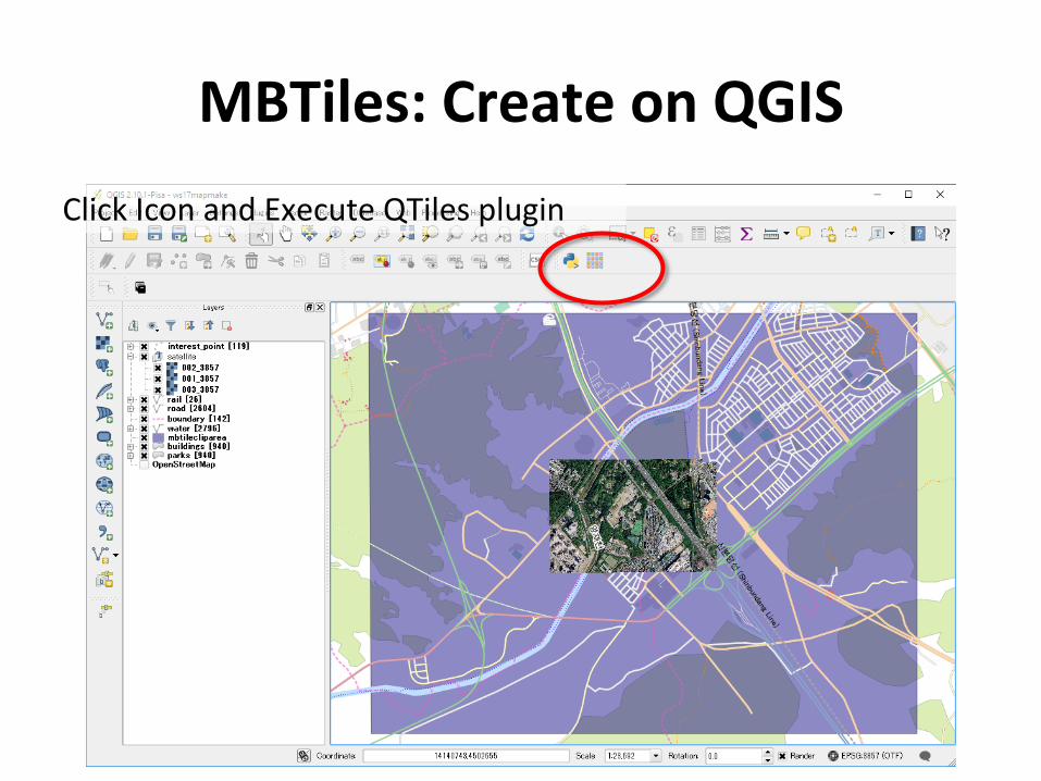
MBTiles: Create on QGIS Click Icon and Execute QTiles plugin

MBTiles: Create on QGIS Click and Turn off “mbClecliparea” Layer

MBTiles: Create on QGIS Select “File” and Click [Browse] BuWon
Select Folder Select “MBTiles databases” Input File name to “ws17map” Click [Save] BuWon

MBTiles: Create on QGIS Input other parameters as follows
Tileset name view in Cle source list
Limit extent of create Cle data
Tile Zoom Level Zoom levels > 18 start to take long Cme to build because the large number of Cles generated In this example case, 17785 Cles will be created and maybe over 15 minutes need.
19 20
foss4g2015ws17(QGIS)

GEOPAPARAZZI: IMPORT MBTILES • Copy the file you created on the Android device in the folder
called maps
• restart Geopaparazzi (close and restart!!)

GEOPAPARAZZI: IMPORT MBTILES • Tap the main menu buWon on the Dashboard
• Select the first entry of the menu: Select Cle source
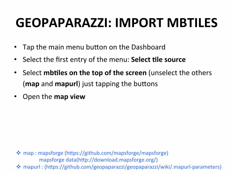
GEOPAPARAZZI: IMPORT MBTILES • Tap the main menu buWon on the Dashboard
• Select the first entry of the menu: Select Cle source
• Select mbCles on the top of the screen (unselect the others (map and mapurl) just tapping the buWons
• Open the map view
v map : mapsforge (hWps://github.com/mapsforge/mapsforge) mapsforge data(hWp://download.mapsforge.org/)
v mapurl : (hWps://github.com/geopaparazzi/geopaparazzi/wiki/.mapurl-‐parameters)

GEOPAPARAZZI: IMPORT MBTILES

STAGE: CONVERT GIS FILES
• Geopaparazzi saves all in a file in the home of the device
• Copy the project file on the PC • Use STAGE to create shape file

STAGE: CONVERT GIS FILES

STAGE: CONVERT GIS FILES
foss4g2015_ws17.gpap
proposed folder

GEOPAPARAZZI: OPEN PROJECT
Prepare the Mapping
• Shutdown Geopaparazzi • Copy the Geopaparazzi project called
“foss4g2015_ws17.gpap” to /strage/emulated/0
• Copy the Geopaparazzi forms called “tags.json” to /strage/emulated/0/geopaparazzi
• Restart your android device or use “SD scanner” to refresh MTP data catalog on your device.
• Open Geopaparazzi • Open the main menu from the dashboard

GEOPAPARAZZI: IMPORT MBTILES

GEOPAPARAZZI: MAPPING
Yangjae CiCzens' Forest Built for the 1986 Asian Games and 1988 Seoul Olympics, the land was prepared on July 1983 as part of Gaepo-‐dong Land Arrangement Plan. The construcCon of the Forest conCnued for about three years and completed on November 1986. The total area is 358,992 square metres (88.709 acres). The park's major faciliCes include landscaped faciliCes, such as Grass Field, Octagonal Pavilion, and Pagora (wisteria trellis). The forest also has sports faciliCes, such as tennis and basketball courts. Other major structures in the Forest include the Memorial Hall for the war hero Yun Bonggil, a parking lot, children's playground, and an outdoor wedding hall.
Let the games begin!! Mission: collect informaCon -‐ picture of the building -‐ civic number -‐ desCnaCon: commercial, residence, ... -‐ number of floor inside (number of doorbells -‐ ...

GEOPAPARAZZI: MAPPING

GEOPAPARAZZI: MAPPING
Highway 8 or more
lanes of wide road
Kill (길) Narrow road than
the “road”
Road (로, b) 2-‐7-‐lane road
Roadname
Building name
The building number is granted from west to east, from south to north, order from the road point of view in 20m interval.
The approximate distance calculate by building number. (5-‐1) x 10m = 40m
Road Number: 64 Roadname: Maeheon-‐ro Building name:203-‐12

Survey new addressing of this area Building General info
-‐ Address road -‐ Civic number (Building number) -‐ Number of floors -‐ Under construcCon -‐ Years of construcCon
Usage -‐ DesCnaCon -‐ Please specify other use
Notes -‐ Notes
Picture -‐ picture of the building
GEOPAPARAZZI: MAPPING

Let the games begin!!

Using form based notes • Edit “tags.json” file
– Open offline geopaparazzi users manual URL – Cut and Paste from samples – save as “tags.json” (UTF-‐8 encode)
• Copy & replace exist “tags.json” file in Geopaparazzi folder • Restart geopaparazzi

Using form based notes: Supported tags
• Text • Text with key and label • Numbers • Labels rendered in the map view • Date • Time • Labels • Checkbox • Combos • Pictures • Sketches • Map screenshot • Other supported tags

Create a simple form to map Building
General info -‐ Address road (mandatory) -‐ Civic number (mandatory) -‐ Number of floors (mandatory) -‐ Under construcCon (mandatory) -‐ Years of construcCon Usage -‐ DesCnaCon (mandatory) residence,commerCal,office,bank,school,producCve,other -‐ Please specify other use Notes -‐ Notes Picture -‐ picture of the building

Create a simple form to map [ { "secConname": "Building", "secCondescripCon": "building", "forms": [ ] } ]

Create a simple form to map Building
General info -‐ Address road (mandatory) -‐ Civic number (mandatory) -‐ Number of floors (mandatory) -‐ Under construcCon (mandatory) -‐ Years of construcCon Usage -‐ DesCnaCon (mandatory) residence,commerCal,office,bank,school,producCve,other -‐ Please specify other use Notes -‐ Notes Picture -‐ picture of the building

Create a simple form to map [ { "secConname": "Building", "secCondescripCon": "building", "forms": [ { "formname": "General info", "formitems": [
] }, { "formname": "Usage", "formitems": [ ] }, { "formname": "Notes", "formitems": [ ] },
{ "formname": "Picture", "formitems": [ ] } ] } ]

Create a simple form to map General info -‐ Address road (mandatory) -‐ Civic number (mandatory) -‐ Number of floors (mandatory) -‐ Under construcCon (mandatory) -‐ Years of construcCon

Create a simple form to map { "formname": "General info", "formitems": [ { "key": "Address road", "value": "", "type": "string", "mandatory": "yes" },
{ "key": "Civic number", "value": "",
"type": "double”, "mandatory": "yes" }, { "key": "Number of floors", "value": "”, "type": "double", "mandatory": "yes" }, { "key": "Under construcCon", "values": { "items": [ { "item": "YES" },{ "item": "NO" } ] }, "value": "NO", "type": "stringcombo", "mandatory": "yes" }, { "key": "Year of construcCon", "value": "", "type": "double", "mandatory": "no" }
] },

Create a simple form to map Usage -‐ DesCnaCon (mandatory) residence,commerCal,office,bank,school,producCve,other -‐ Please specify other use

Create a simple form to map { "formname": "Usage", "formitems": [ { "key": "DesCnaCon", "values": { "items": [ { "item": "" },{ "item": "residence" },{ "item": "commercial" },{ "item": "office" },{ "item": "bank" },{ "item": "school" },{ "item": "producCve" },{ "item": "other" } ] }, "value": "", "type": "stringcombo", "mandatory": "yes" }, { "key": "Please specify other use", "value": "",
"type": "string", "mandatory": "no" } ] },

Create a simple form to map Notes -‐ Notes Picture -‐ picture of the building

Create a simple form to map { "formname": "Notes", "formitems": [ { "key": "Notes", "value": "", "type": "string", "mandatory": "no" } ] }, { "formname": "Picture", "formitems": [ { "key": "Pictures of the building", "value": "", "type": "pictures" } ] }

Edit SpaCal data • Prepare your spaCal database by using SpaCalite-‐Gui • Copy your database file in Maps folder
• Edit on geopaparazzi This secCon is not include this workshop.

Edit SpaCal data • need your ideas

Edit SpaCal data:Add feature • need your ideas

Edit SpaCal data:Add feature • need your ideas

Edit SpaCal data:Add feature • need your ideas

Edit SpaCal data: Reshape feature • need your ideas

Edit SpaCal data: Reshape feature • need your ideas
To specify, the overlapped part is marked with the finger.

Edit SpaCal data: Reshape feature • need your ideas

Edit SpaCal data:Merge feature • need your ideas

Edit SpaCal data:Merge feature • need your ideas