Embed Size (px)
Citation preview
INTERNATIONAL HYDROGRAPHIC
ORGANIZATION
国際水路機関
INTERGOVERNMENTAL
OCEANOGRAPHIC
COMMISSION
政府間海洋学委員会
STANDARDIZATION
OF UNDERSEA
FEATURE NAMES
GUIDELINES
PROPOSAL FORM
TERMINOLOGY
Bathymetric Publication No. 6
4th
Edition, November 2008
English/Japanese Version
Published by the
INTERNATIONAL HYDROGRAPHIC
BUREAU
海底地形名称標準
指針
提案様式
用語
水深測量に関する刊行物6号
第4版 2008年11月
英語/日本語版
国際水路局刊行
MONACO
The version in the Japanese language is a translation of IHO-IOC Publication B-6, 4th edition, in
English. The IHO has not checked the translation and therefore takes no responsibility for its
accuracy. In case of doubt, the source English version should be consulted.
B-6
INTERNATIONAL HYDROGRAPHIC
ORGANIZATION
国際水路機関
INTERGOVERNMENTAL
OCEANOGRAPHIC
COMMISSION
政府間海洋学委員会
STANDARDIZATION
OF UNDERSEA
FEATURE NAMES
GUIDELINES
PROPOSAL FORM
TERMINOLOGY
English/Japanese Version
4th
Edition, November 2008
Bathymetric Publication No. 6
Published by the
INTERNATIONAL HYDROGRAPHIC
BUREAU
海底地形名称標準
指針
提案様式
用語
英語/日本語版
第4版 2008年11月
水深測量に関する刊行物6号
国際水路局刊行
4, quai Antoine 1er
BP 445
MC 98011, Monaco cedex
Principauté de Monaco
Fax: +377 93 10 81 40
E-mail: [email protected]
Website: www.iho.int
MONACO
1-i
FOREWORD
________
The Guidelines, the Name Proposal Form and
the List of Terms and Definitions contained in this
publication have been developed through
collaboration between the "GEBCO Sub-
Committee on Undersea Feature Names",
appointed by the "Joint IOC-IHO Guiding
Committee for GEBCO", and the Working Group
on Maritime and Undersea Features of the "United
Nations Group of Experts on Geographical Names
(UNGEGN)", in accordance with provisions of
appropriate resolutions of United Nations
Conferences on Geographical Names.
This fourth edition of the English/Japanese
version of B-6 supersedes the previous edition
published by the IHB in 2001. Other versions of
this edition are also available in English/French,
English/Spanish, English/Russian, and English/
Korean.
At the request of the "Joint IOC/IHO Guiding
Committee for GEBCO", in order to obtain the
largest distribution of these Guidelines and to bring
the Geographical Names of Undersea Features to a
better Standardization, the B-6 is available gratis
from the IHB and IOC. (See page 2-6 for
addresses). It is also available in digital form from
the IHO website (www.iho.int) and GEBCO
website (www.gebco.net).
________
FOREWORD
________
この出版物に掲載されている指針、地形名提案様式及び用語と定義のリストは、「IOC/IHO 合同 GEBCO 指導委員会」により任命された組織である「海底地形名称に関するGEBCO 小委員会」と、「国連地名専門家グループ(UNGEGN)」の海洋及び海底地形作業部会が国連地名会議の決議にしたがって、協同で作成したものである。
B-6 の英語/日本語バージョンの第 4 版は、2001 年に IHB によって公表された第 3 版に取って代わる。B-6 の他のバージョン:英語/フランス語;英語/スペイン語;英語/ロシア;英語/韓国語、も利用可能である。
この指針を広く行きわたらせ、海底地形名称の標準化を推進するため、「IOC/IHO 合同GEBCO 指導委員会」の要請により、この B-6
は、IHB または IOC から無料で入手可能である(請求先は 2-6 ページを参照)。さらにIHO ウェブサイト(www.iho.int)と GEBCO ウェブサイト(www.gebco.net)から電子版が入手可能である。
________
1-ii
Page intentionally left blank
余白
1-iii
CONTENTS
________
目次
________
- List of acronyms
頭字語一覧表 ....................................................................................................................... 1-iv
- Standardization of Undersea Feature Names - Introduction
海底地形名称の標準化-導入 ............................................................................................ 1-v
- Guidelines for the Standardization of Undersea Feature Names
「海底地形名標準化」の指針 ............................................................................................. 2-1
I. General / 総論
II. Principles for Naming Features /海底地形名称命名の原則
III. Procedures for Naming Features / 海底地形名称命名の手続き
- Undersea Feature Name Proposal Form - English version
- 海底地形名称の提案様式(英語版) (*) .......................................................................... 2-5
- Undersea Feature Name Proposal Forms - Japanese version
海底地形名称の提案様式(日本語版) (*) ...................................................................... 2-7
- Authorities to which the “Undersea Feature Name Proposal Form” should be sent
for clearance, for any feature located in a territorial sea
領海内の「海底地形名称の提案様式」の提出先 ............................................................ 2-9
- Terminology - Notes
用語-注記 .......................................................................................................................... 2-11
- Terms and Definitions
用語と定義 .......................................................................................................................... 2-12
- Index in the Japanese syllabary of the Japanese terms shown in the list of
"Terms and Definitions", with cross-references to the English terms
「用語と定義」日本語用語五十音順索引 ....................................................................... 2-23
________
(*) The "Undersea Feature Name Proposal Form” is also available -- from the IHB -- in the
French, Spanish, Russian and Korian version.
「海底地形名の提案」様式は、英語版、日本語版の他、フランス語版、スペイン語版、
ロシア語版、韓国語版がIHBから入手可能である。
1-iv
LIST OF ACRONYMS
________
GEBCO: General Bathymetric Chart of the
Oceans
IBC: International Bathymetric Chart
IHB: International Hydrographic Bureau
(IHO)
IHO : International Hydrographic
Organization
IOC: Intergovernmental Oceanographic
Commission (UNESCO)
NGA: National Geo-Intelligence Agency
(USA)
PA: Position Approximate
SCUFN: Sub-Committee on Undersea Feature
Names (GEBCO)
UN: United Nations
UNESCO: United Nations Educational,
Scientific and Cultural Organization
________
頭字語一覧表
________
GEBCO: 大洋水深総図
IBC: 国際海底地形図
IHB: 国際水路局
IHO : 国際水路機関
IOC: 政府間海洋学委員会(ユネスコ)
NGA:国家地球空間情報局(アメリカ合衆
国)
PA: 概位
SCUFN: 海底地形名称に関する小委員会
(大洋水深総図)
UN: 国際連合
UNESCO: 国際連合教育科学文化機関
________
1-v
STANDARDIZATION OF UNDERSEA
FEATURE NAMES
________
INTRODUCTION
1. In recent years, considerable concern has
been expressed at the indiscriminate and
unregulated naming of undersea features which
often get into print in articles submitted to
professional journals, or on ocean maps and
charts, without any close scrutiny being made
concerning their suitability, or even whether the
feature has already been discovered and named.
In order to remedy this situation and to bring
the geographical names of undersea features to
a better standardization, the IHO, at its XIIIth
I.H. Conference (May 1987) and the IOC, at its
14th Assembly (March 1987) adopted similar
motions on this subject, the substance of which
is recalled below.
i) Marine scientists and other persons in their
country wishing to name undersea
features, are strongly encouraged to check
their proposals with published Gazetteers
of Undersea Feature Names, taking into
account the guidelines contained in this
document (IHO-IOC publication B-6
"Standardization of Undersea Feature
Names"), including the use of the
"Undersea Feature Name Proposal Form"
contained herein, and to submit all
proposed new names for clearance, either
to their appropriate national authority, or,
where no such national authority exists, to
the IHB or IOC, for consideration by the
"GEBCO Sub-Committee on Undersea
Feature Names", which may advise on any
potentially confusing duplication of
names.
ii) Publishers of ocean maps, and editors of
scientific journals, in their country, are
invited to require compilers and authors to
provide written evidence of such clearance
before accepting for publication any maps
or scientific articles containing new names
for undersea features.
2. In 2008, new Terms of Reference for the
GEBCO Sub-Committee on Undersea
Feature Names (SCUFN) were adopted by
IHO and IOC, including the following:
海底地形名称の標準化
________
導入
1.海底地形名称が、その適切さやすでに発見され命名されたものかなどを十分吟味されないまま、調整されることなく無計画に付与され、科学専門誌に投稿された論文、海洋地図や海図にしばしば記載されることについて、近年、相当の懸念が示されている。
この状況を正し、海底地形名称の標準化を進めるために、IHO はその第 13 回会議(1987 年 5 月)において、また IOC はその第 14 回総会(1987 年 3 月)において、この件に関する動議を採択した。内容を以下に示す。
i) 海底地形名の命名を希望する国内の海洋科学者及び他の人々は、このIHO/IOC の刊行物 B-6「海底地形名称標準」(それに記載されている海底地形名提案様式の使用を含む)の指針を考慮して、彼らの提案を既刊の海底地形名集と照合し、承認を受けたい全ての新名称案を、自国の適切な国家機関、または、それがない国にあっては IHB または IOC のいずれかに、海底地形名称に関するGEBCO 小委員会における検討のために提出することを強く奨励する。当該委員会は、混乱を招く可能性がある地名の重複について助言を与える。
ii) 国内の海洋地図出版者及び科学専門誌の編集者は、新しい海底地形名称を含む地図または論文の刊行を受理する前に、かかる承認の文書による証明を地図編集者または著者に用意してもらうよう要請される。
2. 2008 年に、海底地形名称に関するGEBCO 小委員会(SCUFN)の新しい委任事項は、IHO 及び IOC によって以下の事項を含めて採用された:
1-vi
i. It is the function of the Sub-Committee
to select those names of undersea
features in the world ocean appropriate
for use on GEBCO graphical and digital
products, on the IHO small-scale
INTernational chart series, and on the
regional International Bathymetric Chart
(IBC) series.
ii. The Sub-Committee shall:
select undersea feature names from:
- names provided by national and
international organizations
concerned with nomenclature;
- names submitted to the Sub-
Committee by individuals,
agencies and organizations
involved in marine research,
hydrography, etc.;
- names appearing in scientific
journals or on appropriate charts
and maps;
- names submitted to the Sub-
Committee by the Chairpersons
or Chief Editors of International
Bathymetric Chart projects, in
relation to the work on these
projects.
All selected names shall adhere to the
principles contained in this document
(IHO-IOC Publication B-6
“Standardization of Undersea
Feature Names”) and be supported by
valid evidence. Such names shall
be reviewed before they are added to
the Gazetteer.
define when appropriate the extent of
named features;
provide advice to individuals and
appropriate authorities on the
selection of undersea feature names
located outside the external limits of
the territorial sea and, on request,
inside the external limit of the
territorial sea;
i. 小委員会の役割は、GEBCO の印刷版とデジタル版の出版物、IHO の小縮尺の INT 海図シリーズ、および IOC
の地域的な国際海底地形図(IBC)シリーズでの使用において適切な、世界の海の海底地形名称を選択することである。
ii. 小委員会は以下のことを行う:
以下に基づいて海底地形名称を選択する:
- 命名に関係のある国家組織および国際組織が規定する名;
- 海洋研究や水路学などに関与する個人、機関および組織から小委員会に提出される名;
- 科学専門誌あるいは適切な海図および地図上に出現する名;
- 国際海底地形図計画の作業において、同計画の議長または編集長から小委員会に提出される名。
全ての選択された海底地形名称は、このIHO/IOC の刊行物 B-6「海底地形名称標準」に記された命名の原則に忠実であり、正当な根拠によって立証されるものとする。そのような海底地形名称は海底地形名集に追加される前に審査を受けるものとする。
可能な場合、命名された地形の範囲を定義する
個人および適切な機関に対して、領海の限界線の外側の、または依頼があれば領海内の、海底地形名称の選択についての助言を与える;
1-vii
encourage the establishment of
national boards of geographical
names and undersea features when
such boards do not exist;
prepare and maintain an international
and worldwide IHO-IOC GEBCO
Gazetteer of Undersea Feature
Names;
encourage the use of undersea feature
names included in the IHO-IOC
GEBCO Gazetteer, on any maps,
charts, scientific publications, and
documents by promulgating these
names widely;
prepare and maintain internationally
agreed guidelines for the
standardization of undersea feature
names and encourage their use;
review and address the need for
revised or additional terms and
definitions for submarine topographic
features;
Maintain close liaison with the UN
Group of Experts on Geographical
Names, the focal point of which shall
be invitations to attend meetings of
the Sub-Committee, and with
international or national authorities
concerned with the naming of
undersea features;
Provide, where feasible, historical
information regarding the origin of
pre-existing published names and
historical variant names. This
research will include discovery ship
and/or organization, information
regarding the individual or vessel
being commemorated or geographic
feature with which the name is
associated, origin of variant names if
required and source material
regarding naming information.
_________
地形名称および海底地形に関する国家委員会が存在しない国に対し、その設立を奨励する。
国際的かつ世界的な GEBCO の海底地形名集を準備し、維持する;
GEBCO の海底地形名集に示された海底地形名称を地図、海図、科学的な出版物や文書に使用することを推奨し、広く普及させる;
海底地形名称の標準化のために国際的に合意された指針を準備、維持し、使用を奨励する;
海底地形の属名及びその定義について、改訂または追加の必要性を調査し、検討する;
国連地名専門家グループ(その中心人物に対しては、小委員会の会合に出席するよう勧誘を行う)、および海底地形の命名に関係のある国際機関または国家機関と緊密な連絡を維持する;
可能な場合、既に存在する海底地形名称及びそ歴史的には異なって呼称されていた名称の起源についての歴史的情報を提供する。この調査は、発見した船舶または組織、記念されるべき個人または船舶、または名称に関連する地理的な特徴についての情報を含み、必要であれば歴史的には異なって呼称されていた名称の起源、名称の情報についての原資料を含む。
_________
1-viii
Page intentionally left blank
余白
2-1
GUIDELINES FOR THE
STANDARDIZATION OF UNDERSEA
FEATURE NAMES
________
I. GENERAL
A. International concern for naming undersea
features is limited to those features entirely or
mainly (more than 50%) outside the external limits
of the territorial sea, not exceeding 12 nautical
miles from the baselines, in agreement with the
United Nations Convention on the Law of the Sea.
B. "Undersea feature" is a part of the ocean floor
or seabed that has measurable relief or is
delimited by relief.
C. Names used for many years may be accepted
even through they do not conform to normal
principles of nomenclature. Existing names
may be altered to avoid confusion, remove
ambiguity or to correct spelling.
D. Names approved by national names authorities
in waters beyond the territorial sea should be
accepted by other States if the names have
been applied in conformance with
internationally accepted principles. Names
applied within the territorial sea of a State
should be recognized by other States.
E. In the event of a conflict, the persons and/or
agencies involved should resolve the matter.
Where two names have been applied to the
same feature, the older name generally should
be accepted. Where a single name has been
applied to two different features, the feature
named first generally should retain the name.
F. Names not in the writing system of the
country applying the names on maps or other
documents should be transliterated according
to the system adopted by the national authority
applying the names.
G. In international programmes, it should be the
policy to use forms of names applied by
national authorities having responsibility for
the pertinent area.
H. States may utilize their preferred versions of
海底地形名称標準化の指針
________
I. 総論
A. 海底地形名称の命名に関して国際的関心は、当該地形の全部または相当部分(50%以上)が、領海の外縁線(国連海洋法条約に従って、基線から 12 マイルを超えない)の外側にある地形に限られる。
B. 「海底地形」とは、大洋底あるいは海底の一部で、測定可能な起伏を有するか、起伏によって境界が定められるものをいう。
C. 長年にわたり使用されてきた海底地形名称は、命名の一般原則に合致しないものでも受け入れられる。既存の名称は、混乱を避けるため、曖昧さを解消するため、またスペルを直すために変更することもあり得る。
D. 領海を越えた海域内における、ある国の地名当局によって承認された名称は、それが国際的に受容される原則に従って命名されている場合には、他の国もこれを受入れるべきである。各国の領海内に付されている名称については、他国もこれを承認すべきである。
E. 意見の相違が生じた場合は、その問題に関与している者と(または)機関が解決に当るべきである。同一の地形に対して二つの海底地形名称がある場合には、一般に、使用時期が早い方の名称が受理されるべきである。異なる二つの地形に対して同じ名称が付されている場合は、一般に、先にその名称が付された地形にその名称を残すべきである。
F. 地図またはその他記述に名称を採用する際、その国の表記法にない名称は、その国の地名当局が採用している方式に則り翻訳されるべきである。
G. 国際プログラムにおいては、当該地域に責任を有する国の当局が採用している地名様式に従う方針を用いるべきである。
H. 各国は、その国が好む別名を使用するこ
2-2
exonyms.
II. PRINCIPLES FOR NAMING FEATURES
A. Specific terms
1. Short and simple terms (or names) are
preferable.
2. The principal concern in naming is to provide
effective, conveniently usable, and appropriate
reference; commemoration of persons or ships
is a secondary consideration.
3. The first choice of a specific term, where
feasible, should be one associated with a
geographical feature; e.g.: Aleutian Ridge,
Aleutian Trench, Peru-Chile Trench, Barrow
Canyon.
4. Specific terms for other features can be used
to commemorate ships or other vehicles,
expeditions or scientific institutes involved in
the discovering and/or delineation of the
feature, or to honour the memory of famous
persons. Where a ship name is used, it should
be that of the discoverering ship, or if that has
been previously used for a similar feature, it
should be the name of the ship verifying the
feature, e.g.: San Pablo Seamount, Atlantis II
Seamounts.
5. Names of living persons will normally not be
accepted, in accordance with the
recommendation in UNCSGN Resolution
VIII/2. In the rare cases where names of
living persons are used (surnames are
preferable), they will be limited to those who
have made an outstanding or fundamental
contribution to ocean sciences.
6. Groups of like features may be named
collectively for specific categories of
historical persons, mythical features, stars,
constellations, fish, birds, animals, etc.
Examples are as follows:
とができる。
II. 海底地形名称命名の原則
A. 固有名
1. 短くかつ簡潔な用語(または名称)が望ましい。
2. 命名にあたっての原則は、その名称が効果的で使い易く、適切な参照となることである。個人名または船名を記念する名称は、第二義的なものである。
3. 可能な場合、固有名には地勢と関連する名称をまず選択するべきである; 例:アリューシャン海嶺、アリューシャン海溝、ペルー・チリ海溝、バーロウ海底谷
4. その他の地形に対する固有名は、その海底地形の発見と(あるいは)境界の決定に関係した船またはその他の機器、探検隊または研究所を記念するため、あるいは著名な個人の栄誉をたたえるためにその名称を使用することができる。船名を用いる場合は、その地形を発見した船の名称を、またはその名称が同様の地形にすでに用いられている場合は、その地形を確証した船の名称を当てるべきである。 例:サンペドロ海山、アトランティス II 世海山
5. 生存している者の名前は、国連地名標準化会議の決議案 VIII/2 に則して基本的に認められない。仮に生存している者の名前(姓が望ましい)を用いる場合は、海洋科学に顕著な、あるいは重要な貢献をした者の名に限られる。
6. 似かよった地形の集まりに対して、集合的な固有名として、歴史上の人物、神話の事象、星、星座、魚、鳥、動物等の名称を付与する事が出来る。例は以下の通り:
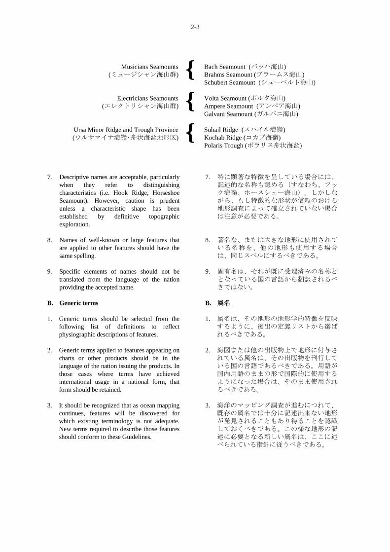
2-3
Musicians Seamounts
(ミュージシャン海山群) {
Bach Seamount (バッハ海山)
Brahms Seamount (ブラームス海山)
Schubert Seamount (シューベルト海山)
Electricians Seamounts
(エレクトリシャン海山群) {
Volta Seamount (ボルタ海山)
Ampere Seamount (アンペア海山)
Galvani Seamount (ガルバニ海山)
Ursa Minor Ridge and Trough Province
(ウルサマイナ海嶺・舟状海盆地形区) {
Suhail Ridge (スハイル海嶺)
Kochab Ridge (コカブ海嶺)
Polaris Trough (ポラリス舟状海盆)
7. Descriptive names are acceptable, particularly
when they refer to distinguishing
characteristics (i.e. Hook Ridge, Horseshoe
Seamount). However, caution is prudent
unless a characteristic shape has been
established by definitive topographic
exploration.
8. Names of well-known or large features that
are applied to other features should have the
same spelling.
9. Specific elements of names should not be
translated from the language of the nation
providing the accepted name.
B. Generic terms
1. Generic terms should be selected from the
following list of definitions to reflect
physiographic descriptions of features.
2. Generic terms applied to features appearing on
charts or other products should be in the
language of the nation issuing the products. In
those cases where terms have achieved
international usage in a national form, that
form should be retained.
3. It should be recognized that as ocean mapping
continues, features will be discovered for
which existing terminology is not adequate.
New terms required to describe those features
should conform to these Guidelines.
7. 特に顕著な特徴を呈している場合には、記述的な名称も認める(すなわち、フック海嶺、ホースシュー海山)。しかしながら、もし特徴的な形状が信頼のおける地形調査によって確立されていない場合は注意が必要である。
8. 著名な、または大きな地形に使用されている名称を、他の地形も使用する場合は、同じスペルにするべきである。
9. 固有名は、それが既に受理済みの名称ととなっている国の言語から翻訳されるべきではない。
B. 属名
1. 属名は、その地形の地形学的特徴を反映するように、後出の定義リストから選ばれるべきである。
2. 海図または他の出版物上で地形に付与されている属名は、その出版物を刊行している国の言語であるべきである。用語が国内用語のままの形で国際的に使用するようになった場合は、そのまま使用されるべきである。
3. 海洋のマッピング調査が進むにつれて、既存の属名では十分に記述出来ない地形が発見されることもあり得ることを認識しておくべきである。この様な地形の記述に必要となる新しい属名は、ここに述べられている指針に従うべきである。
2-4
III. PROCEDURES FOR NAMING
FEATURES
A. Individuals and agencies applying names to
unnamed features located outside the external
limit of the territorial sea should adhere to
internationally accepted principles and
procedures.
B. It is recommended that new proposals should
be submitted on an "Undersea Feature Name
Proposal” as at pages 2-5/2-6.
C. Prior to the naming of a feature, its character,
extent, and position shall have been
established sufficiently for identification.
Positions should be given in terms of
geographic co-ordinates. If it is necessary to
refer to a feature before such identification has
been established, it is suggested that the
reference be by geographic co-ordinates and
generic terms with the addition of (PA) --
position approximate -- after the co-ordinates
if the position is not adequately established
and (?) after the generic term if the nature of
the feature is in some doubt.
D. Where no national authority exists, clearance
should be sought through either IHB or the
IOC Secretariat, as indicated on the "Proposal
Form". See also page 2-9.
E. If a national authority decides to change the
name of a feature it named originally,
information explaining the reason for the
change should be circulated to other
authorities. If there is opposition to a name
change, the involved authorities should
communicate with each other to agree on a
solution.
F. National authorities approving names of
features should regularly publicize their
decisions.
G. National authorities naming features within
their territorial sea should conform to the
principles and procedures stated above.
________
III. 地形名称命名の手続き
A. 個人や機関が国際水域内のまだ名称のない地形に名称を付する場合は、国際的に認められた原則及び手続きを厳守すべきである。
B. 地形名称提案は、2-5/2-6 ページの「海底地形名称提案様式」によって提出されるよう勧告する。
C. 地形の命名に先立ち、その同定のために、特徴、範囲、位置を十分に確かめなければならない。位置は地理的座標で示されるべきである。確認がなされる前にその地形について言及する必要が生じた場合は、地理的座標と属名でもって言及するが、位置が十分に確定していない場合は、座標の後に(PA)-概位-を、またその地形の特徴になんらかの疑問が残っている場合は属名の後に、(?)を付記しておくことを推奨する。
D. 該当する当局がない場合には、「提案様式」に記載されている IHB または IOC
事務局を通じて承認を得るようにすべきである。2-9 ページも参照のこと。
E. 国家の当局が元々付けられていた地形の名称を変更することを決定する場合は、その変更するに至った理由を、他の国の当局に回章しなければならない。名称変更に反対意見がある場合は、関係当局は合意に達するために相互に連絡をとらなければならない。
F. 地形名称を承認する国家の当局は、その決定を定期的に公表すべきである。
G. 領海内の地形を命名する各国の地名当局は、上記の原則と手続きに従うべきである。
________
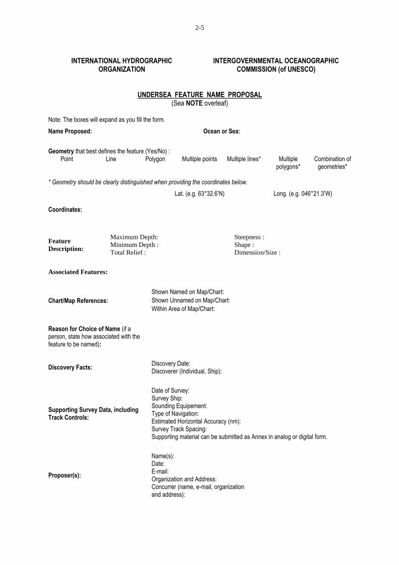
2-5
INTERNATIONAL HYDROGRAPHIC
ORGANIZATION INTERGOVERNMENTAL OCEANOGRAPHIC
COMMISSION (of UNESCO)
UNDERSEA FEATURE NAME PROPOSAL (Sea NOTE overleaf)
Note: The boxes will expand as you fill the form.
Name Proposed: Ocean or Sea:
Geometry that best defines the feature (Yes/No) : Point Line Polygon Multiple points Multiple lines* Multiple
polygons* Combination of
geometries*
* Geometry should be clearly distinguished when providing the coordinates below.
Lat. (e.g. 63°32.6’N) Long. (e.g. 046°21.3’W)
Coordinates:
Feature
Description:
Maximum Depth: Steepness :
Minimum Depth : Shape :
Total Relief : Dimension/Size :
Associated Features:
Chart/Map References:
Shown Named on Map/Chart: Shown Unnamed on Map/Chart: Within Area of Map/Chart:
Reason for Choice of Name (if a person, state how associated with the feature to be named):
Discovery Facts: Discovery Date: Discoverer (Individual, Ship):
Supporting Survey Data, including Track Controls:
Date of Survey: Survey Ship: Sounding Equipement: Type of Navigation: Estimated Horizontal Accuracy (nm): Survey Track Spacing: Supporting material can be submitted as Annex in analog or digital form.
Proposer(s):
Name(s): Date: E-mail: Organization and Address: Concurrer (name, e-mail, organization and address):
2-6
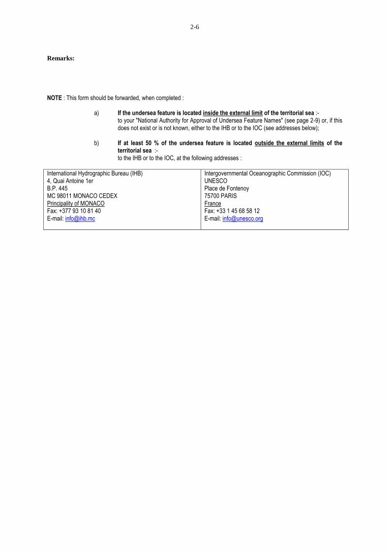
Remarks:
NOTE : This form should be forwarded, when completed :
a) If the undersea feature is located inside the external limit of the territorial sea :- to your "National Authority for Approval of Undersea Feature Names" (see page 2-9) or, if this does not exist or is not known, either to the IHB or to the IOC (see addresses below);
b) If at least 50 % of the undersea feature is located outside the external limits of the
territorial sea :- to the IHB or to the IOC, at the following addresses :
International Hydrographic Bureau (IHB) 4, Quai Antoine 1er B.P. 445 MC 98011 MONACO CEDEX Principality of MONACO Fax: +377 93 10 81 40 E-mail: [email protected]
Intergovernmental Oceanographic Commission (IOC) UNESCO Place de Fontenoy 75700 PARIS France Fax: +33 1 45 68 58 12 E-mail: [email protected]
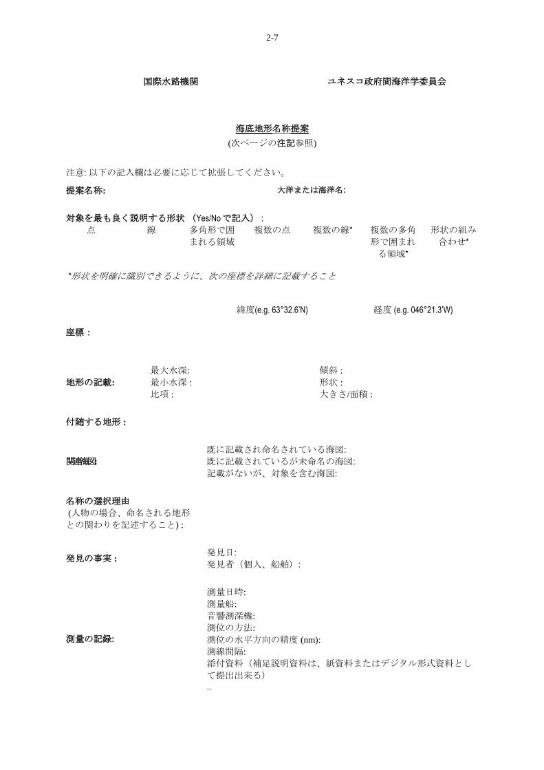
2-7
国際水路機関
ユネスコ政府間海洋学委員会
海底地形名称提案
(次ページの注記参照)
注意: 以下の記入欄は必要に応じて拡張してください。
提案名称: 大洋または海洋名:
対象を最も良く説明する形状 (Yes/Noで記入) :
点 線 多角形で囲
まれる領域
複数の点 複数の線* 複数の多角
形で囲まれ
る領域*
形状の組み
合わせ*
*形状を明確に識別できるように、次の座標を詳細に記載すること
緯度(e.g. 63°32.6’N) 経度 (e.g. 046°21.3’W)
座標:
地形の記載:
最大水深: 傾斜 :
最小水深 : 形状 :
比項 : 大きさ/面積 :
付随する地形 :
関連海図:
既に記載され命名されている海図: 既に記載されているが未命名の海図:
記載がないが、対象を含む海図:
名称の選択理由
(人物の場合、命名される地形
との関わりを記述すること) :
発見の事実 : 発見日:
発見者(個人、船舶):
測量の記録:
測量日時:
測量船:
音響測深機:
測位の方法:
測位の水平方向の精度 (nm):
測線間隔:
添付資料(補足説明資料は、紙資料またはデジタル形式資料とし
て提出出来る)
..
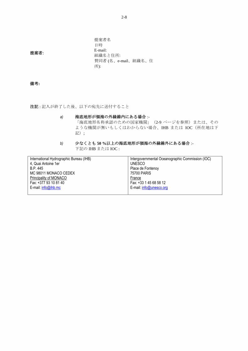
2-8
提案者:
提案者名
日時
E-mail:
組織名と住所:
賛同者 (名、e-mail、組織名、住
所):
備考:
注記 : 記入が終了した後、以下の宛先に送付すること
a) 海底地形が領海の外縁線内にある場合 :-
「海底地形名称承認のための国家機関」(2-9 ページを参照)または、その
ような機関が無いもしくはわからない場合、IHB または IOC(所在地は下
記);
b) 尐なくとも 50 %以上の海底地形が領海の外縁線外にある場合 :-
下記の IHB または IOC :
International Hydrographic Bureau (IHB) 4, Quai Antoine 1er B.P. 445 MC 98011 MONACO CEDEX Principality of MONACO Fax: +377 93 10 81 40 E-mail: [email protected]
Intergovernmental Oceanographic Commission (IOC) UNESCO Place de Fontenoy 75700 PARIS France Fax: +33 1 45 68 58 12 E-mail: [email protected]
2-9
AUTHORITIES TO WHICH
THE "UNDERSEA FEATURE
NAME PROPOSAL FORM"
SHOULD BE SENT FOR CLEARANCE,
FOR ANY FEATURE LOCATED IN A
TERRITORIAL SEA
________
Notes:
1) Proposal forms for features located
inside the external limit of a territorial sea should
be submitted to the relevant Hydrographic Office
(see references on the IHO website; www.iho.int
> Administration > Member States) and/or the
national naming authority. Some national
institutions are listed below.
2) Proposal forms for features located
inside the external limit of the territorial sea of a
country not appearing on the IHO website should
be submitted to the IHB or to the IOC (See
addresses on Pages 2-6).
領海内の海底地形に対する「海底地形名称の
提案様式」の提出先の当局のリスト
注記:
1) 領海の外縁線の内側の地形についての提
案様式は、当該国の海洋情報当局 (IHO Web
サイト上の参考事項を参照 : www.iho.int >
Administration > Member States)、及び/また
は国家地名命名当局に提出すること。いくつ
かの国家機関は以下に掲載する。
2) IHO Web サイトに掲載されていない国の
領海の外縁線の内側の地形についての提案様
式は、IHB または IOC に提出すること。(2-
6 ページの住所を参照)
Canada -カナダ Geographical Names Board of Canada
Advisory Committee on Names for
Undersea and Maritime Features
615 Booth Street, Room 209
OTTAWA, Ontario, K1A OE6
Fax: + 1 (613) 947-4369
Finland - フィンランド Onamastic Division
Centre of Domestic languages
Liisankatu 16A
SF-00170 HELSINKI
Fax: + 358 204 48 4555
Israel - イスラエル The Marine Geology Section
Geological Survey of Israel
30 Malchei Israel Street
JERUSALEM 95 501
Libya - リビア Survey Department of Libya
P.O. Box 600
TRIPOLI
China - 中国 The China Committee on Geographical
Names
Bai Wan Zhuang
11 jianguomennei Avenue
BEIJING – 100736
Fax: + 86 10 652 92245
Germany - ドイツ Staendiger Ausschuss für Geographische
Namen (STAGN) – Geschaeftsstelle im
Institut für Angewandle Geodaesie
Richard-Strauss-Allee 11
D-6000 FRANKFURT/MAIN
Kenya - ケニア Direction of Surveys
Survey of Kenya
P.O. Box 30046
NAIROBI
Mexico - メキシコ Dirección General de Geografía
Instituto Nacional de Estadística, Geografía e
Informática (INEGI)
Av. Héroe de Nacozari Sur Nº 2301,
puerta 8, 2º nivel
Col. Jardines del Parque
C.P. 20270, Aguascalientes
MEXICO
Fax: 449 442 41 76
2-10
New Zealand - ニュージーランド New Zealand Geographic Board Ngā Pou
Taunaha o Aotearoa
Private Box 5501
Wellington 6145
NEW ZEALAND
Sweden - スウェーデン
The Swedish IOC Committee
P.O. Box 6711
S-113 85 STOCKHOLM
Poland - ポーランド Urzad Rady Ministrow
Komisja Ustalania Nazw Miejscowosci
i Obiektow Fizjograficznych
(Bureau of the Cabinet, Board for
determining of the Names of Places and
Physiographical Objects)
Aleje Ujazdowskie 1/3
00-583 WARSZAWA
United States of America - アメリカ合衆国 U.S. Board on Geographic Names
National Geospatial-Intelligence Agency
(NGA)
Department of Defense
Mail Stop D-61
Bethesda, Maryland 20816-5003
Fax: +1 (301) 227 5515
__________
2-11
TERMINOLOGY
________
NOTES (See "FOREWORD", page 1-i)
The List which follows is comprised of terms that
are defined as closely as possible to correspond to
their usage in references appearing in the literature
of ocean science, hydrography and exploration. In
developing the definitions, it was realized that
modern investigations at sea have the advantage of
using very advanced instrumentation and
technology that enables a more precise description
of certain features than was previously possible.
This has sometimes lead to finding that historically
named features, do not physically exist. There has
also been an attempt to limit the usage of precise
physical dimensions in the definition of features. In
preference, words that indicate relative sizes such
as extensive, large, limited and small have been
used. The definitions are based almost exclusively
on a geomorphological description of the features
themselves; implications as to origin and
composition have been avoided. They must not be
construed as having any legal or political
connotation whatsoever. Nor do they necessarily
conform to the hydrographic/navigation usage as
appearing in the Hydrographic Dictionary (IHO
Special Publication No. 32).
It is realized that some named features, such as
"cap" and “pass" have widely accepted longtime
usage. No attempt has been made to refine or
define them since they are no longer used in
modern physiographic terminology. Where those
features are noted in the GEBCO gazetteer of
Undersea Feature Names (Publication B-8), an
alternative terminology is provided in the
„remarks‟ area.
________
用語
________
注記(1-i ページの「はじめに」参照)
ここに収めた用語リストは、海洋科学、水路学お
よび調査に関連する文献にみられる用法と可能な
限り一致するように定義されている。この定義を
作るにあたり、現代の海洋研究は、以前と比較し
て、地形についてのより厳密な記述を可能とする
進歩した機器や技術を使う利点を有していること
が実感された。例えば、歴史的に命名された地形
が、新しい調査によって実際には存在しないこと
が判明したケースがあった。また、地形の定義に
あたって、厳密に実際の大きさを用いることによ
って定義することを制限しようとする考えもあっ
た。ここでは、相対的な規模を表す言葉、たとえ
ば、広範囲な、大きい、限定的な、小さい、とい
ったものが用いられている。ここに示した定義
は、地形自体の地形学的記述にほぼ全面的に立脚
するものであって、その起源や組成に関する含意
は排除されている。更に、ここに示した定義は何
らかの法的あるいは政治的な意味を含むものと解
釈されてはならない。また、ここに示した定義
は、水路学事典(IHO特別刊行物 32 号)に示さ
れている水路学/航海学の用法に必ずしも従って
はいない。
「キャップ」や「パス」等の幾つかの既存の属名
は長い間にわたって広く使われている。しかし、
これらの属名は、現代地形学の用語としては、も
はや使用されていないため、これらの用法の精密
化や定義は行わない。これらの地形がGEBCO 海
底地形名集(出版物B-8)に記載されている場合
は、代替の属名が注釈欄に示されている。
________
2-12
UNDERSEA FEATURE
TERMS AND DEFINITIONS
Note : Terms written in capitals in the definitions,
are themselves defined elsewhere in the list.
________
海底地形
用語と定義
注記:定義の中に大文字で書かれた属名は、それ
自身がリスト内の他の場所で定義されてい
る。
________
ABYSSAL HILL(S)
An isolated (or tract of) small elevation(s) on the
deep seafloor.
深海丘(群)
深海底にある、孤立した小さな高まり(深海底に
ある、多くの小さな高まりがある地域)。
ABYSSAL PLAIN
An extensive, flat, gently sloping or nearly level
region at abyssal depths.
e.g.: Biscay Abyssal Plain
深海平原
深海における、広大かつ平坦であり、緩やかに傾
斜するか、ほとんど水平な地域。
APRON
A gently dipping surface, underlain primarily by
sediment, at the base of any steeper SLOPE.
e.g.: West Aves Apron
エプロン
急な斜面の基部に見られる、主に堆積物より成る
なだらかな斜面。
ARCHIPELAGIC APRON
A gentle SLOPE with a generally smooth surface of
the sea floor, characteristically found around
groups of islands or SEAMOUNTS.
e.g.: Marquesas Archipelagic Apron
群島エプロン
特に、群島や海山群の周辺にみられる緩やかな斜
面で、一般に海底面は滑らかである。
BANK(S)
An isolated (or group of) elevation(s) of the sea
floor, over which the depth of water is relatively
shallow, but sufficient for safe surface navigation.
e.g.: Georges Bank
堆(群)
海底にある比較的浅いが、海上の安全航行には十
分な深さを持つ孤立した(一群の)高まり。
例:大和堆
BASIN
A depression, in the sea floor, more or less
equidimensional in plan and of variable extent.
e.g.: Brazil Basin
海盆
海底にある平面的には多尐とも等方形を示す凹地
で、大きさは様々である。
例:日本海盆
2-13
BORDERLAND
A region adjacent to a continent, normally
occupied by or bordering a SHELF and
sometimes emerging as islands, that is irregular or
blocky in plan or profile, with depths well in
excess of those typical of a SHELF.
e.g.: California Borderland
大陸境界地
大陸に隣接する地域で、普通は大陸棚が占める地
域か、大陸棚に接する地域にあり、時に島として
現れる。典型的な大陸棚よりかなり深く、上方も
しくは側方から見て、不規則または塊状の形状を
示す。
CALDERA
A collapsed or partially-collapsed SEAMOUNT,
commonly of annular shape.
e.g.: Albacora Caldera (off Portugal)
カルデラ
崩壊した海山、または一部環状に崩壊した海山
で、一般に環状の形状を示す。
例:明神礁カルデラ
CANYON(S)
An isolated (or group of) relatively narrow, deep
depression(s) with steep sides, the bottom of
which generally deepens continuously, developed
characteristically on some continental SLOPES.
e.g.: Hudson Canyon
海底谷(群)
孤立した(一群の)比較的狭く、かつ深い凹地
で、両側は急な斜面をなす。底が一般に連続的に
深くなり、大陸斜面に特徴的に発達する場合があ
る。
例:天竜海底谷
CONE (See FAN)
コーン
(海底扇状地参照)
CONTINENTAL MARGIN
The zone, generally consisting of SHELF, SLOPE
and CONTINENTAL RISE, separating the
continent from the deep sea floor or ABYSSAL
PLAIN. Occasionally a TRENCH may be present
in place of a CONTINENTAL RISE.
大陸縁辺部
大陸と深海底または深海平原を分ける地帯で、通
常、陸棚、大陸斜面及びコンチネンタルライズか
らなる。コンチネンタルライズの代わりに海溝が
存在しているところもある。
CONTINENTAL RISE
A gentle slope rising from the oceanic depths
towards the foot of a continental SLOPE.
コンチネンタルライズ
大洋の深部から大陸斜面の基部にわたる緩やかな
斜面。
CONTINENTAL SHELF (See SHELF)
大陸棚
(陸棚参照)
DEEP(S)
An isolated (or group of) localized deep area(s)
within the confines of a larger feature, such as a
TROUGH, BASIN or TRENCH.
e.g.: Challenger Deep
海淵(群)
舟状海盆、海盆、海溝といったより大きな地形内にある孤立した
(一群の)局所的に深い箇所。
例:チャレンジャー海淵
2-14
ESCARPMENT
An elongated, characteristically linear, steep slope
separating horizontal or gently sloping sectors of
the sea floor in non-SHELF areas. Also
abbreviated to SCARP.
e.g.: Mendocino Escarpment
海底崖
非陸棚域の水平あるいは緩く傾斜する海底を分断
する、特徴的に線状に伸びた、急峻な斜面。
SCARPと省略されることもある。
例:北奄美海底崖
FAN
A relatively smooth, fan-like, depositional feature
normally sloping away from the outer termination
of a CANYON or canyon system. Also called
CONE.
e.g.: Delgada Fan
海底扇状地
比較的なめらかな扇状の堆積地形で、通常、海底
谷または海底谷系の末端に発達する。CONEとも
呼ばれる。
例:茂木海底扇状地
FRACTURE ZONE
An extensive linear zone of irregular topography,
mountainous or faulted, characterized by steep-
sided or asymmetrical RIDGES, clefts,
TROUGHS or ESCARPMENTS.
e.g.: Murray Fracture Zone
断裂帯
長い距離にわたって直線状に不規則な山地または
断層地形で、急峻な斜面、または非対称断面を有
する海嶺、断裂、舟状海盆、あるいは海底崖によ
って特徴付けられる。
GAP (See PASSAGE)
海裂
(PASSAGEを参照)
GUYOT(S)
An isolated (or group of) SEAMOUNT(S) having
a comparatively smooth flat top. Also called
TABLEMOUNT(S). See also SEAMOUNT(S).
e.g.: Welker Guyot
平頂海山(群)
比較的滑らかで平らな頂部を持つ、孤立した(一
群の)海山。卓状海山とも呼ばれている。
SEAMOUNT(S)を参照。
例:ほとけのざ(平頂)海山
HILL(S)
An isolated (or group of) elevation(s), smaller
than a SEAMOUNT. See also ABYSSAL
HILL(S) and KNOLL(S).
e.g.: Nukak Hill (Caribbean Sea)
海丘(群)
海山よりも小さい、孤立した(一群の)高まり。
ABYSSAL HILL(S)とKNOLL(S)を参照。
例:串本海丘
2-15
HOLE
A small local depression, often steep sided, in the
sea floor.
e.g.: Tenza Hole (Caribbean Sea)
海穴
海底の小さく局所的な凹地。しばしば急斜面に境
される。
例:新月海穴
KNOLL(S)
An elevation somewhat smaller than a
SEAMOUNT and of rounded profile,
characteristically isolated or as a cluster on the
sea floor. See also HILL(S).
e.g.: Cantabria Knoll.
海丘(群)
海山よりもやや小さく、丸い輪郭を持った、孤立
した(一群の)高まり。
HILL(S) を参照。
例:第二天竜海丘
LEVEE A depositional natural embankment bordering a
CANYON, VALLEY or SEACHANNEL on the
ocean floor.
海底堤防
海底の堆積性の自然堤防で、海底谷、海谷または
長谷を縁どる。
MEDIAN VALLEY
The axial depression of the MID-OCEANIC
RIDGE system.
中軸谷
中央海嶺系の中軸部の凹地。
MID-OCEANIC RIDGE (See RIDGE (c) and RISE (b))
中央海嶺
(RIDGE (c)、RISE (b) を参照)
MOAT
An annular depression that may not be continuous,
located at the base of many SEAMOUNTS,
oceanic islands and other isolated elevations.
e.g.: Hawaiian Moat.
周辺凹地
多くの海山、大洋中の島、その他孤立した高まり
の麓にある環状の凹地で、連続しない事もある。
PASSAGE
A narrow break in a RIDGE or a RISE. Also called
GAP. e.g.: Theta Gap
海裂
海嶺または海膨に見られる狭い切れ目。GAPとも
呼ばれる。
2-16
PEAK(S)
An isolated (or group of) prominent elevation(s)
either pointed or of a very limited extent across the
summit.
e.g. Confederation Peak.
峰(群)
その頂部が尖っているか、頂上の広さがごく限ら
れている、孤立した(一群の)顕著な高まり。
PINNACLE(S)
A discrete (or group of) high tower or spire-shaped
pillar(s) of rock, or coral, isolated or cresting a
summit.
e.g.: Gardner Pinnacles.
尖礁(群)
高い塔状か、尖った柱状の孤立した(一群の)岩
またはサンゴ。
PLATEAU
A flat or nearly flat elevation of considerable areal
extent, dropping off abruptly on one or more sides.
e.g.: Blake Plateau.
海台
平坦ないしはほぼ平坦な高まりで、相当な広さを
有する。一つないしそれ以上の側面が急に深くな
っている。
例:小笠原海台
PROMONTORY
A major SPUR-like protrusion of the continental
SLOPE extending to the deep seafloor.
Characteristically, the crest deepens seaward.
e.g.: Estremadura Promontory (off Portugal)
海岬
大陸斜面の大きな突出で、海脚状に深海底に伸び
る。頂部の水深が海側へ向かって増すことが特徴
である。
PROVINCE
A region identifiable by a number of shared
physiographic characteristics that are markedly in
contrast with those in the surrounding areas.
e.g.: Gulf of Alaska Seamount Province
地形区
多くの共通の地形学的特徴によって他と区別され
る地域で、その特徴は周辺の地形とは顕著な対照
をなす。
REEF(S)
A mass (or group) of rock(s) or other indurated
material lying at or near the sea surface that may
constitute a hazard to surface navigation.
e.g.: Great Barrier Reef
礁(群)
海面か海面近くにある岩または固化した物質、ま
たはその一群。海上航行の障害になりうる。
2-17
RIDGE(S) (Several meanings)
(a) An isolated (or group of) elongated narrow
elevation(s) of varying complexity having
steep sides.
e.g.: Wyville- Thomson Ridge
(b) An isolated (or group of) elongated narrow
elevation(s), often separating ocean BASINS.
e.g.: Walvis Ridge.
(c) The linked major mid-oceanic mountain
systems of global extent. Also called MID-
OCEANIC RIDGE.
e.g.: Mid-Atlantic Ridge.
海嶺(群)(この用語には、いくつかの意味があ
る)
(a) 孤立した(一群の)急峻な斜面を有する伸長
した狭い高まりで、その複雑さは様々である。
例:大東海嶺
(b) 孤立した(一群の)伸長した狭い高まり
で、しばしば大洋の海盆を分ける。
例:九州・パラオ海嶺
(c) 地球規模で連なった大洋の中央山系。中央海
嶺とも呼ばれる。
RISE (Several meanings)
(a) A broad elevation that rises gently and
generally smoothly from the sea floor.
e.g.: Argentine Rise.
(b) The linked major mid-oceanic mountain
systems of global extent. Also called MID-
OCEANIC RIDGE.
e.g.: East Pacific Rise.
海膨(この用語には、いくつかの意味がある)
(a) 海底から緩やかにかつ全体としてなだらかに
隆起している幅広い高まり。
例:日本海膨
(b) 地球規模で連なった大洋の中央山系。中央海
嶺とも呼ばれる。
SADDLE
A broad pass or col, resembling in shape a riding
saddle, in a RIDGE or between contiguous
elevations.
e.g.: Montebello Saddle
鞍部
幅広の稜線の低い部分で、海嶺の中、または隣接
し合う高まりの間にある。馬の鞍に似た形状を持
つ。
SCARP (See ESCARPMENT)
海底崖
(ESCARPMENTを参照)
SEA VALLEY(S) (See VALLEY(S))
海谷(群)
(VALLEY(S)を参照)
2-18
SEACHANNEL(S)
A continuously sloping elongated discrete (or
group of) depression(s) found in FANS or
ABYSSAL PLAINS and customarily bordered by
LEVEES on one or both sides.
e.g.: Moresby Seachannel
長谷(群)
連続的に傾斜する独立した(一群の)伸長した凹
地で、海底扇状地または深海平原に見られる。通
常、片側または両側に海底堤防を伴う。
例:富山深海長谷
SEAMOUNT(S)
A discrete (or group of) large isolated
elevation(s), greater than 1,000m in relief above
the sea floor, characteristically of conical form.
See also GUYOT.
e.g.: New England Seamounts, Emperor Seamounts.
海山(群)
一つの(一群の)大きな孤立した高まりで、海洋
底から1,000m以上の比高を持ち、特徴的に円錐形
をなす。GUYOTを参照。
例:白鳳海山、春の七草海山群
SEAMOUNT CHAIN
A linear or arcuate alignment of discrete
SEAMOUNTS, with their bases clearly separated.
See also SEAMOUNT(S).
海山列
線状または弧状の配列をなして連なる海山群。
個々の海山の基部は明瞭に離れている。海山(群)
参照。
例:天皇海山列、紀单海山列
SHELF
A zone adjacent to a continent (or around an
island) and extending from the low water line to a
depth at which there is usually a marked increase
of slope towards oceanic depths.
e.g.: Scotian Shelf.
陸棚
大陸に隣接する(または島の周囲の)地帯で、低
潮線から大洋の深部に向って傾斜が著しく増加す
る所までをさす。
SHELF BREAK (See SHELF-EDGE)
大陸棚外縁
(SHELF-EDGEを参照)
SHELF-EDGE
The line along which there is marked increase of
slope at the seaward margin of a
CONTINENTAL (or island) SHELF. Also called
SHELF BREAK.
大陸棚外縁
大陸の(島の)陸棚の海側の端で、顕著に傾斜が
増大する箇所に沿った線。SHELF BREAKとも呼
ばれる。
2-19
SHOAL(S)
An isolated (or group of) offshore hazard(s) to
surface navigation with substantially less
clearance than the surrounding area and
composed of unconsolidated material.
e.g.: Georges Shoal.
瀬(群)
孤立した(一群の)周辺地域よりかなり浅く海上
航行に危険な沖合の箇所で、未固結底質からな
る。
SILL
A sea floor barrier of relatively shallow depth
restricting water movement between BASINS.
シル
比較的水深の浅い箇所での海底の柵状の地形で、
海盆の間での海水の動きを限定するもの。
SLOPE
The deepening sea floor out from the SHELF-
EDGE to the upper limit of the CONTINENTAL
RISE, or the point where there is a general
decrease in steepness.
大陸斜面
大陸棚外縁から下部の斜面であり、コンチネンタ
ルライズの上限までに至るまで、もしくは急勾配
の減尐が見られる箇所までの斜面をいう。
SPUR
A subordinate elevation or RIDGE protruding
from a larger feature, such as a PLATEAU or
island foundation.
海脚
海台あるいは島の基盤などの規模の大きな地形か
ら突出している高まりまたは海嶺。
SUBMARINE VALLEY(S) (See VALLEY(S))
海谷(群)
(VALLEY(S)を参照)
TABLEMOUNT(S) (See GUYOT(S))
卓状海山(群)
(GUYOT(S)を参照)
TERRACE(S)
An isolated (or group of) relatively flat horizontal
or gently inclined surface(s), sometimes long and
narrow, which is(are) bounded by a steeper
ascending slope on one side and by a steeper
descending slope on the opposite side.
e.g.: Meriadzek Terrace.
平坦面(群)
比較的平坦で、水平または緩く傾斜する孤立した
(一群の)表面で、時に細長い形状を呈す。片方
が急な上り斜面で、他方が急な下り斜面で境界さ
れる。
2-20
TRENCH
A long narrow, characteristically very deep and
asymmetrical depression of the sea floor, with
relatively steep sides.
海溝
細長く、特徴的に非常に深い、非対称断面を示す
海底の凹地。比較的急峻な斜面を有する。
例:日本海溝
TROUGH A long depression of the sea floor characteristically
flat bottomed and steep sided and normally
shallower than a TRENCH.
e.g.: Rockall Trough, Langseth Trough.
舟状海盆
海底の細長い凹地で、特徴的に平坦な底と急峻な
斜面を有し、通常、海溝より浅い。
例:单海舟状海盆、沖縄舟状海盆
VALLEY(S)
An isolated (or group of) relatively shallow, wide
depression(s), the bottom of which usually has a
continuous gradient. This term is generally not
used for features that have CANYON-like
characteristics for a significant portion of their
extent. Also called SUBMARINE VALLEY(S) or
SEA VALLEY(S).
__________
海谷(群)
比較的浅く、幅の広い、孤立した(一群の)凹地
で、その底は、普通、順傾斜を示す。この属名
は、相当な部分に亘って海底谷状の特徴を有する
地形に対しては、一般に使用しない。
SUBMARINE VALLEY(S)または SEA VALLEY(S)
とも呼ばれる。
例:吐噶喇(トカラ)海谷
_________
2-21
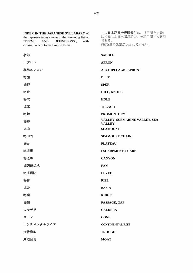
INDEX IN THE JAPANESE SYLLABARY of
the Japanese terms shown in the foregoing list of
"TERMS AND DEFINITIONS", with
crossreferences to the English terms.
この日本語五十音順索引は、「用語と定義」に掲載した日本語用語の、英語用語への索引である。
#複数形の設定が成されていない。
鞍部 SADDLE
エプロン APRON
群島エプロン ARCHIPELAGIC APRON
海淵 DEEP
海脚 SPUR
海丘 HILL, KNOLL
海穴 HOLE
海溝 TRENCH
海岬 PROMONTORY
海谷 VALLEY, SUBMARINE VALLEY, SEA
VALLEY
海山 SEAMOUNT
海山列 SEAMOUNT CHAIN
海台 PLATEAU
海底崖 ESCARPMENT, SCARP
海底谷 CANYON
海底扇状地 FAN
海底堤防 LEVEE
海膨 RISE
海盆 BASIN
海嶺 RIDGE
海裂 PASSAGE, GAP
カルデラ CALDERA
コーン CONE
コンチネンタルライズ CONTINENTAL RISE
舟状海盆 TROUGH
周辺凹地 MOAT
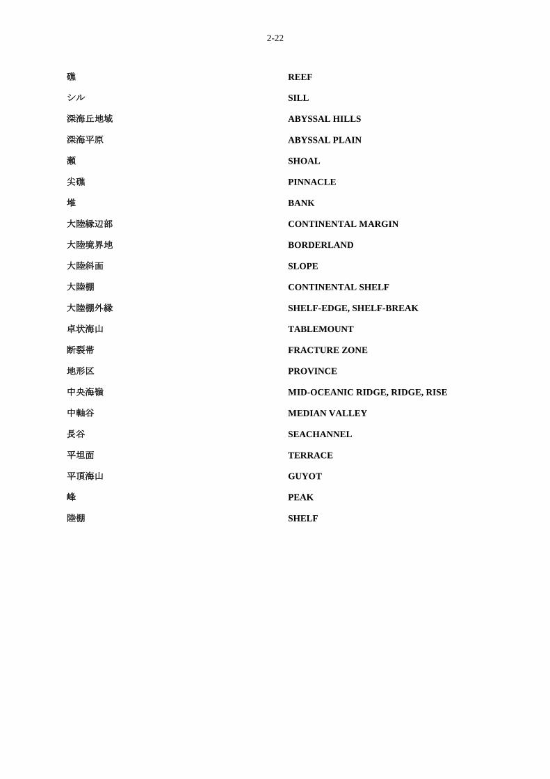
2-22
礁 REEF
シル SILL
深海丘地域 ABYSSAL HILLS
深海平原 ABYSSAL PLAIN
瀬 SHOAL
尖礁 PINNACLE
堆 BANK
大陸縁辺部 CONTINENTAL MARGIN
大陸境界地 BORDERLAND
大陸斜面 SLOPE
大陸棚 CONTINENTAL SHELF
大陸棚外縁 SHELF-EDGE, SHELF-BREAK
卓状海山 TABLEMOUNT
断裂帯 FRACTURE ZONE
地形区 PROVINCE
中央海嶺 MID-OCEANIC RIDGE, RIDGE, RISE
中軸谷 MEDIAN VALLEY
長谷 SEACHANNEL
平坦面 TERRACE
平頂海山 GUYOT
峰 PEAK
陸棚 SHELF