Embed Size (px)
Citation preview

NAVAJO UMTRA LTSM UPDATE
Madeline Roanhorse
Navajo AML / UMTRA Department
2010 Long-Term Surveillance and Maintenance Conference
Grand Junction, Colorado

Navajo UMTRA LTSM Update
Background and HistoryShiprock siteMexican Hat siteTuba City siteContact Information

Navajo UMTRA Background and History
Cooperative Agreement exist between the Navajo Nation and DOE to address the former surface cleanup and the current ground water remediation activities at the four Navajo sites
Three Navajo sites located at Shiprock, NM; Mexican Hat, UT; and Tuba City, AZ
These sites have been transferred to the DOE LTSM Program for oversight and monitoring
Navajo UMTRA is coordinating with DOE the site transfer of the Monument Valley property to the DOE LTSM Program

DOE and NN EPA personnel during the 2010 annual inspection discussing minor depression
due to past core sampling activities.
Navajo UMTRA Background & History, cont.
Program staff performs quarterly and participates in the annual LTSM inspection with the DOE LTSM Program
The quarterly inspection allows frequent monitoring of the Navajo sites in support of the annual inspection
Site inspection include the assessment of the disposal cell top and side slopes; existence of vegetation on cell; conditions of diversion and outflow channels; terrace and outlying site perimeter area and continue

Navajo UMTRA Background and History, cont.
Condition of access road to the cell, fence repairs, entrance and perimeter signs, site markers, survey and boundary monuments, and erosion control markers
Down gradient ground water seep locations away from the disposal cell property
Ensure compliance to disposal cell regulations and standards for long term maintenance

SHIPROCK UMTRA SITE
Shiprock Site
Walk-through assessment is performed to check for evidence of settling, slumping, erosion, animal burrowing and deep-rooted vegetation on the riprap covered top, side slopes and disturbed areas
Check conditions and type of vegetation in channels
Check for slope retreat and tension cracks near the escarpment
Document new wind-blown sand near site fence line Inspect fence around and condition of the pond Completed radon / gamma radiation exposure
assessment of disposal cell cover in support of the 2000 DOE survey

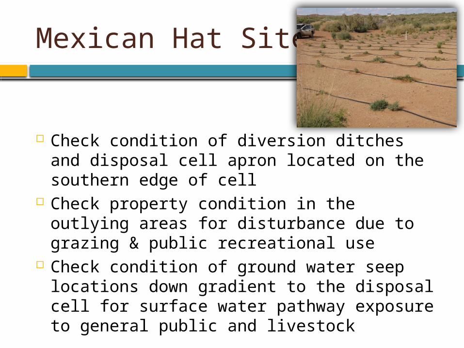
Mexican Hat UMTRA disposal cell

Mexican Hat Site
Walk-through assessment is performed to check for evidence of settling, slumping, erosion, animal access and burrowing and deep-rooted vegetation (biointrusion) on the riprap covered top and side slopes
Check conditions, document location and type of vegetation in the diversion and erosion channels
Document erosion and trash build-up along the boundary fence line
Document condition of boundary fence and evidence of trespass

BIOINTRUSION
Mexican Hat Site, cont.
Check condition of diversion ditches and disposal cell apron located on the southern edge of cell
Check property condition in the outlying areas for disturbance due to grazing & public recreational use
Check condition of ground water seep locations down gradient to the disposal cell for surface water pathway exposure to general public and livestock

TUBA CITY UMTRA SITE

Tuba City Site
Walk-through assessment is performed to check evidence of settling, slumping, erosion, rock cover degradation, animal burrowing and deep-rooted vegetation on the riprap cover top and side slopes
Document and evaluate impact of sand accumulation in the diversion channels
Conduct perimeter site monitoring of the fence line, monitoring wells, signs, monuments, site markers
Document sand accumulation and wind erosion along boundary fence line

Contact Information
Website Address:www.aml.navajo.org
www.lm.doe.gov