Embed Size (px)
Citation preview
NPOESS Preparatory Project (NPP)
Status
Jim GleasonNPP Project Scientist
2
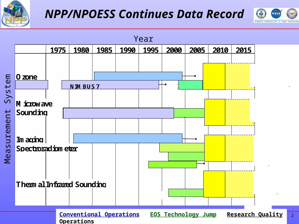
NPP/NPOESS Continues Data Record
Ozone
MicrowaveSounding
ImagingSpectroradiometer
Thermal Infrared Sounding
2010 20151975 1980 1985 1990 1995 2000 2005
NIMBUS 7 M3 EP
N9 N11 N14 N16
NOAA 7 N9 N11 N12 N14 N16
MODIS
TERRA
AQUA
AIRS
MODIS
OMPS(Ozone Mapping and Profiler Suite)
ATMS (Advanced TechnologyMicrowave Sounder)
VIIRS(Visible/Infrared Imaging Radiometer Suite)
CrIS(Cross-track Infrared Sounder)
NPP
NPP
NPP
NPP
NPOESS
NPOESS
NPOESS
NPOESS
AURA
AQUA
AQUA
N17
OMINIMBUS 4
MSU:TIROS-N N6-14 AMSU:N15-17
SeaWIFS
Year
Mea
sure
men
t Sys
tem
Conventional Operations EOS Technology Jump Research Quality Operations
3
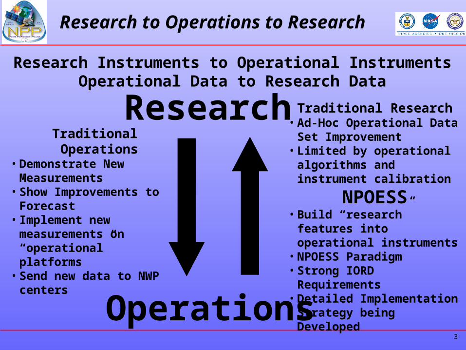
Research to Operations to Research
Research
Operations
Traditional Operations• Demonstrate New
Measurements• Show Improvements to
Forecast• Implement new
measurements on “operational” platforms
• Send new data to NWP centers
Traditional Research• Ad-Hoc Operational Data Set
Improvement• Limited by operational
algorithms and instrument calibration
NPOESS• Build “research” features
into operational instruments• NPOESS Paradigm• Strong IORD Requirements• Detailed Implementation
Strategy being Developed
Research Instruments to Operational InstrumentsOperational Data to Research Data
4
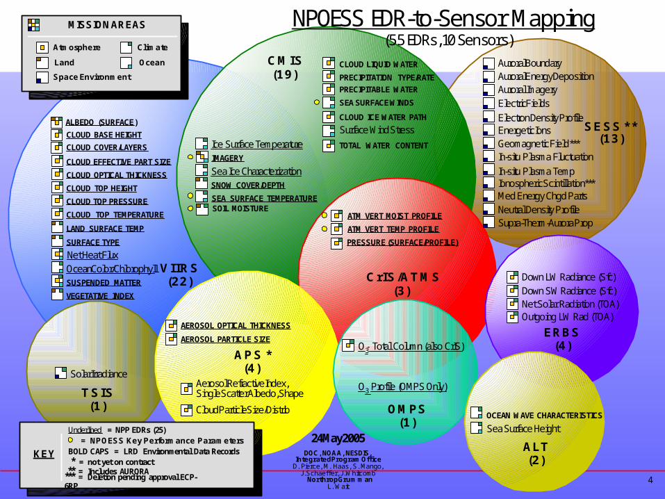
NPOESS EDR-to-Sensor Mapping
VIIRS(22)
CMIS(19)
Solar Irradiance
TSIS(1)
AEROSOL OPTICAL THICKNESS
AEROSOL PARTICLE SIZE
Cloud Particle Size/Distrib
Aerosol Refractive Index,Single Scatter Albedo, Shape
OCEAN WAVE CHARACTERISTICS
Sea Surface Height
Down LW Radiance (Sfc)Down SW Radiance (Sfc)Net Solar Radiation (TOA)Outgoing LW Rad (TOA)
Auroral BoundaryAuroral Energy Deposition
Electric FieldsElectron Density Profile
Auroral Imagery
Energetic IonsGeomagnetic Field ***In-situ Plasma Fluctuation
Ionospheric Scintillation ***Med Energy Chgd PartsNeutral Density ProfileSupra-Therm-Aurora Prop
In-situ Plasma Temp
CrIS/ATMS(3)
OMPS(1)
ALT(2)
APS *(4)
O3 Total Column (also CrIS)
O3 Profile (OMPS Only)
CLOUD LIQUID WATER
CLOUD ICE WATER PATH
PRECIPITATION TYPE/RATE
PRECIPITABLE WATER
Surface Wind StressTOTAL WATER CONTENT
SEA SURFACE WINDS
24 May 2005DOC, NOAA, NESDIS,
Integrated Program OfficeD. Pierce, M. Haas, S. Mango,
J. Schaeffer, J. WhitcombNorthrop Grumman
L. Wait
PRESSURE (SURFACE/PROFILE)
ATM VERT MOIST PROFILE
ATM VERT TEMP PROFILE
ERBS(4)
KEY BOLD CAPS = LRD Environmental Data Records* = not yet on contract
Underlined = NPP EDRs (25)
Climate
Ocean
Atmosphere
Space Environment
Land
MISSION AREAS
(55 EDRs, 10 Sensors)
= NPOESS Key Performance Parameters
** = Includes AURORA*** = Deletion pending approval ECP-6RP
Ice Surface Temperature
SOIL MOISTURESEA SURFACE TEMPERATURE
IMAGERY
SNOW COVER/DEPTH
Sea Ice Characterization
SESS **(13)
Net Heat Flux
CLOUD EFFECTIVE PART SIZE
CLOUD OPTICAL THICKNESS
CLOUD TOP HEIGHT
CLOUD TOP PRESSURE
CLOUD TOP TEMPERATURE
Ocean Color/ChlorophyllSUSPENDED MATTER
VEGETATIVE INDEX
LAND SURFACE TEMP
SURFACE TYPE
CLOUD COVER/LAYERS
ALBEDO (SURFACE)
CLOUD BASE HEIGHT
5
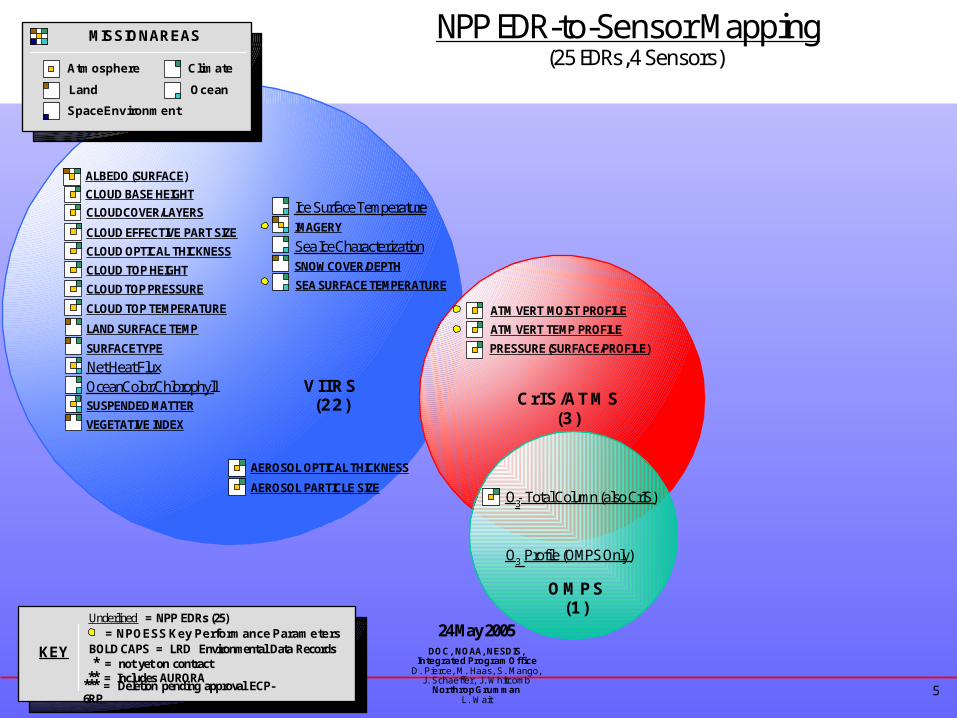
NPP EDR-to-Sensor Mapping
VIIRS(22)
AEROSOL OPTICAL THICKNESS
AEROSOL PARTICLE SIZE
CrIS/ATMS(3)
OMPS(1)
O3 Total Column (also CrIS)
O3 Profile (OMPS Only)
24 May 2005DOC, NOAA, NESDIS,
Integrated Program OfficeD. Pierce, M. Haas, S. Mango,
J. Schaeffer, J. WhitcombNorthrop Grumman
L. Wait
PRESSURE (SURFACE/PROFILE)
ATM VERT MOIST PROFILE
ATM VERT TEMP PROFILE
KEY BOLD CAPS = LRD Environmental Data Records* = not yet on contract
Underlined = NPP EDRs (25)
Climate
Ocean
Atmosphere
Space Environment
Land
MISSION AREAS
(25 EDRs, 4 Sensors)
= NPOESS Key Performance Parameters
** = Includes AURORA*** = Deletion pending approval ECP-6RP
Ice Surface Temperature
SEA SURFACE TEMPERATURE
IMAGERY
SNOW COVER/DEPTH
Sea Ice Characterization
Net Heat Flux
CLOUD EFFECTIVE PART SIZE
CLOUD OPTICAL THICKNESS
CLOUD TOP HEIGHT
CLOUD TOP PRESSURE
CLOUD TOP TEMPERATURE
Ocean Color/ChlorophyllSUSPENDED MATTER
VEGETATIVE INDEX
LAND SURFACE TEMP
SURFACE TYPE
CLOUD COVER/LAYERS
ALBEDO (SURFACE)
CLOUD BASE HEIGHT
6
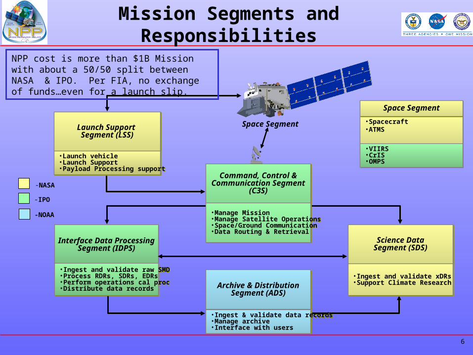
Mission Segments and Responsibilities
Space Segment
-NASA
-IPO
-NOAA
Command, Control &Communication Segment
(C3S)
Command, Control &Communication Segment
(C3S)
•Manage Mission •Manage Satellite Operations•Space/Ground Communication•Data Routing & Retrieval
•Manage Mission •Manage Satellite Operations•Space/Ground Communication•Data Routing & Retrieval
Launch Support Segment (LSS)
Launch Support Segment (LSS)
•Launch vehicle•Launch Support•Payload Processing support
•Launch vehicle•Launch Support•Payload Processing support
Space SegmentSpace Segment
•Spacecraft •ATMS
•VIIRS•CrIS•OMPS
•VIIRS•CrIS•OMPS
Interface Data ProcessingSegment (IDPS)
Interface Data ProcessingSegment (IDPS)
•Ingest and validate raw SMD•Process RDRs, SDRs, EDRs•Perform operations cal proc•Distribute data records
•Ingest and validate raw SMD•Process RDRs, SDRs, EDRs•Perform operations cal proc•Distribute data records Archive & Distribution
Segment (ADS)Archive & Distribution
Segment (ADS)
•Ingest & validate data records•Manage archive•Interface with users
•Ingest & validate data records•Manage archive•Interface with users
Science DataSegment (SDS)Science Data
Segment (SDS)
•Ingest and validate xDRs•Support Climate Research•Ingest and validate xDRs•Support Climate Research
NPP cost is more than $1B Mission with about a 50/50 split between NASA & IPO. Per FIA, no exchange of funds…even for a launch slip.
7
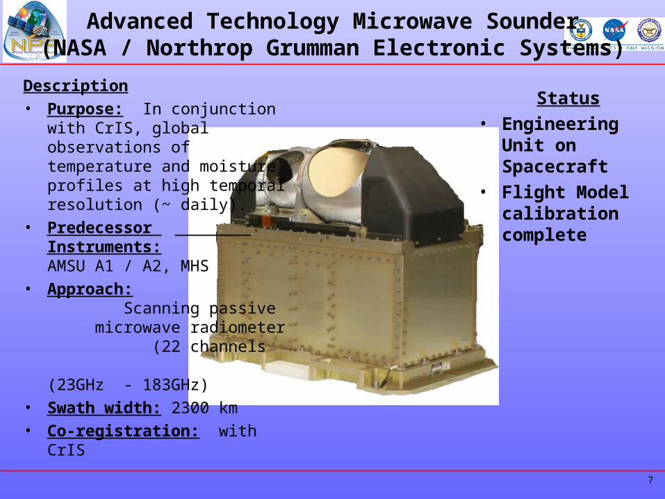
Advanced Technology Microwave Sounder(NASA / Northrop Grumman Electronic Systems)
Description
• Purpose: In conjunction with CrIS, global observations of temperature and moisture profiles at high temporal resolution (~ daily).
• Predecessor Instruments: AMSU A1 / A2, MHS
• Approach: Scanning passive microwave radiometer (22 channels (23GHz - 183GHz)
• Swath width: 2300 km
• Co-registration: with CrIS
Status• Engineering Unit
on Spacecraft • Flight Model
calibration complete
8
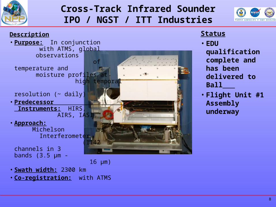
Cross-Track Infrared SounderIPO / NGST / ITT Industries
Description• Purpose: In conjunction
with ATMS, global observations of temperature and moisture profiles at high temporal resolution (~ daily)
• Predecessor Instruments: HIRS, AIRS, IASI
• Approach: Michelson Interferometer (1142 channels in 3 bands (3.5 µm - 16 µm)
• Swath width: 2300 km• Co-registration: with ATMS
Status• EDU qualification
complete and has been delivered to Ball
• Flight Unit #1 Assembly underway
9
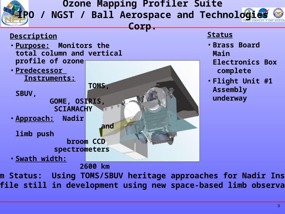
Ozone Mapping Profiler SuiteIPO / NGST / Ball Aerospace and Technologies Corp.
Description• Purpose: Monitors the total
column and vertical profile of ozone
• Predecessor Instruments: TOMS, SBUV, GOME, OSIRIS, SCIAMACHY
• Approach: Nadir and limb push broom CCD spectrometers
• Swath width: 2600 km
Status• Brass Board Main
Electronics Box complete
• Flight Unit #1 Assembly underway
Algorithm Status: Using TOMS/SBUV heritage approaches for Nadir InstrumentsLimb profile still in development using new space-based limb observation data
10
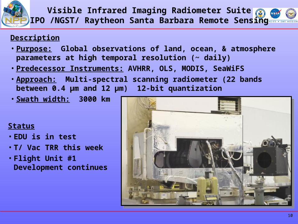
Visible Infrared Imaging Radiometer SuiteIPO /NGST/ Raytheon Santa Barbara Remote Sensing
Description
• Purpose: Global observations of land, ocean, & atmosphere parameters at high temporal resolution (~ daily)
• Predecessor Instruments: AVHRR, OLS, MODIS, SeaWiFS
• Approach: Multi-spectral scanning radiometer (22 bands between 0.4 µm and 12 µm) 12-bit quantization
• Swath width: 3000 km
Status• EDU is in test• T/ Vac TRR this week• Flight Unit #1 Development
continues
11
NASA’s NPP Science Role
• Climate data record (CDR): “a time series of measurements of sufficient length, consistency, and continuity to determine climate variability and change.” (National Research Council: Climate Data Records from Environmental Satellites, 2004)
• The NPP Science Charter is to: Continue the scientific data record started in the “EOS era.”
• NASA is moving toward “Measurement-based”, not “Mission-based,” science and data processing teams.
• The Mission Goals are to produce integrated EOS/NPP/NPOESS satellite data records.
12
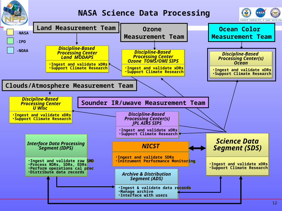
NASA Science Data Processing
-NASA
-IPO
-NOAA Discipline-Based Processing Center
Land MODAPS
Discipline-Based Processing Center
Land MODAPS
•Ingest and validate xDRs•Support Climate Research•Ingest and validate xDRs•Support Climate Research
Discipline-Based Processing Center
Ozone TOMS/OMI SIPS
Discipline-Based Processing Center
Ozone TOMS/OMI SIPS
•Ingest and validate xDRs•Support Climate Research•Ingest and validate xDRs•Support Climate Research
Interface Data ProcessingSegment (IDPS)
Interface Data ProcessingSegment (IDPS)
•Ingest and validate raw SMD•Process RDRs, SDRs, EDRs•Perform operations cal proc•Distribute data records
•Ingest and validate raw SMD•Process RDRs, SDRs, EDRs•Perform operations cal proc•Distribute data records
Archive & DistributionSegment (ADS)
Archive & DistributionSegment (ADS)
•Ingest & validate data records•Manage archive•Interface with users
•Ingest & validate data records•Manage archive•Interface with users
Discipline-Based Processing Center(s)
Ocean
Discipline-Based Processing Center(s)
Ocean
•Ingest and validate xDRs•Support Climate Research•Ingest and validate xDRs•Support Climate Research
Discipline-Based Processing Center
U Wisc
Discipline-Based Processing Center
U Wisc
•Ingest and validate xDRs•Support Climate Research•Ingest and validate xDRs•Support Climate Research
Discipline-Based Processing Center(s)
JPL AIRS SIPS
Discipline-Based Processing Center(s)
JPL AIRS SIPS
•Ingest and validate xDRs•Support Climate Research•Ingest and validate xDRs•Support Climate Research
Land Measurement Team Ocean Color Measurement Team
Ozone Measurement Team
Clouds/Atmosphere Measurement Team
Sounder IR/uwave Measurement Team
NICSTNICST
•Ingest and validate SDRs•Instrument Performance Monitoring•Ingest and validate SDRs•Instrument Performance Monitoring
Science DataSegment (SDS)Science Data
Segment (SDS)
•Ingest and validate xDRs•Support Climate Research•Ingest and validate xDRs•Support Climate Research
13
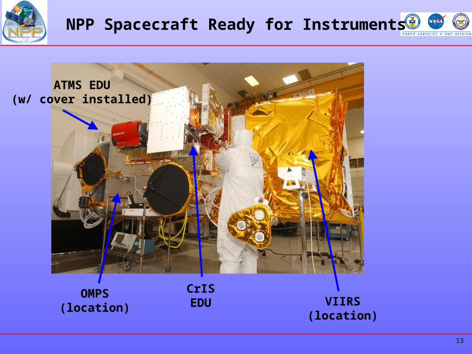
NPP Spacecraft Ready for Instruments
ATMS EDU(w/ cover installed)
CrISEDU VIIRS
(location)
OMPS(location)
14
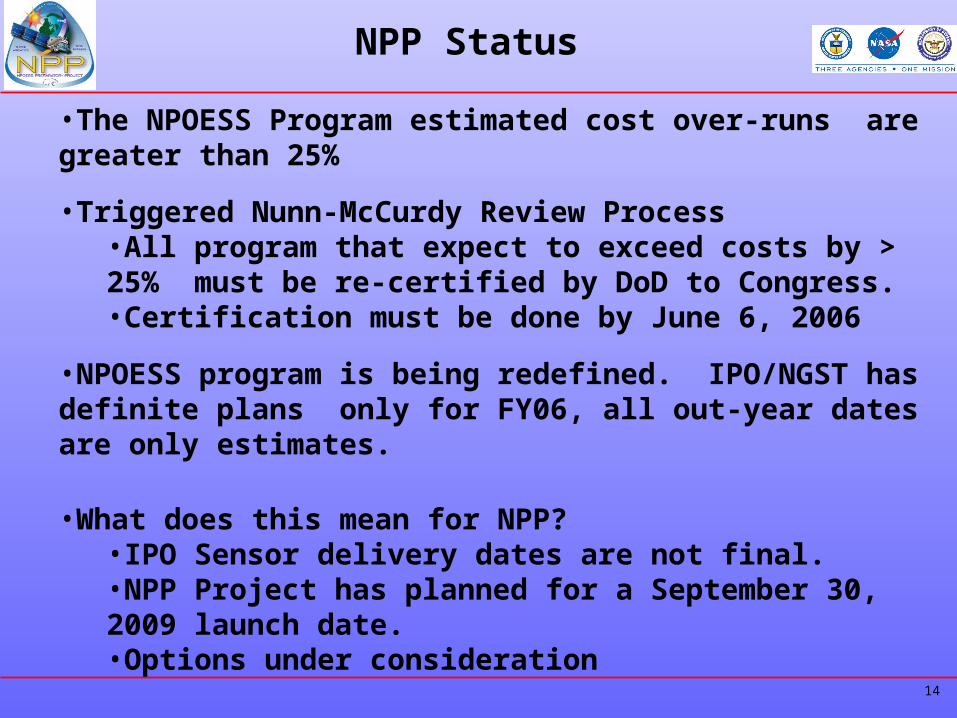
NPP Status
•The NPOESS Program estimated cost over-runs are greater than 25%
•Triggered Nunn-McCurdy Review Process•All program that expect to exceed costs by > 25% must be re-certified by DoD to Congress.•Certification must be done by June 6, 2006
•NPOESS program is being redefined. IPO/NGST has definite plans only for FY06, all out-year dates are only estimates.
•What does this mean for NPP?•IPO Sensor delivery dates are not final.•NPP Project has planned for a September 30, 2009 launch date.•Options under consideration
•Expect Significant Changes to the NPOESS Program
15
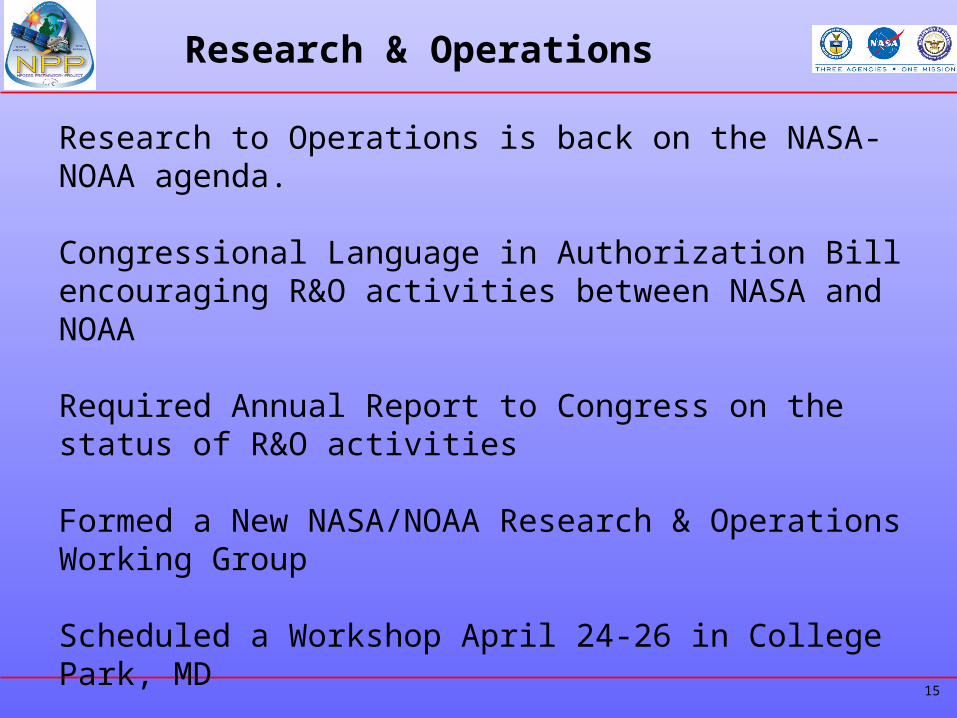
Research & Operations
Research to Operations is back on the NASA-NOAA agenda.
Congressional Language in Authorization Bill encouraging R&O activities between NASA and NOAA
Required Annual Report to Congress on the status of R&O activities
Formed a New NASA/NOAA Research & Operations Working Group
Scheduled a Workshop April 24-26 in College Park, MD
16
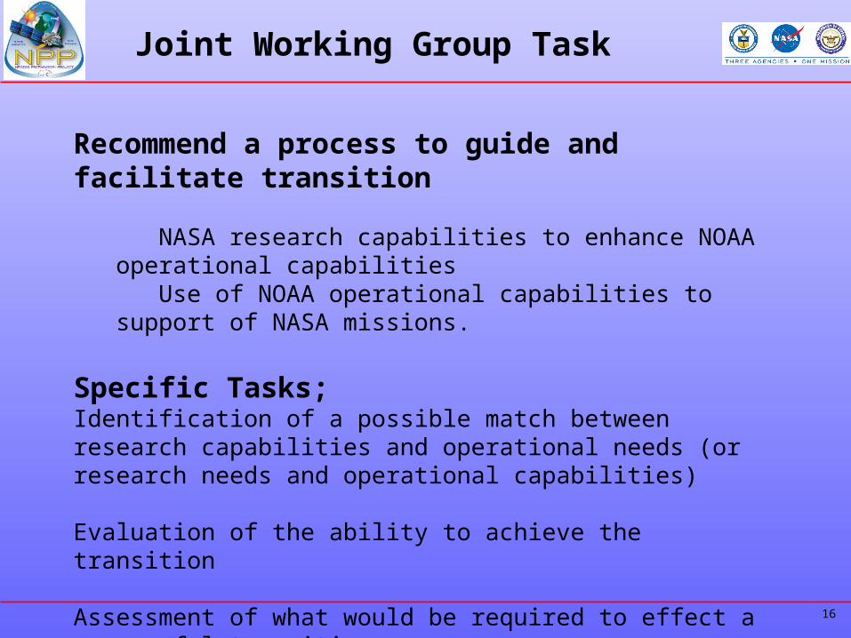
Joint Working Group Task
Recommend a process to guide and facilitate transition
NASA research capabilities to enhance NOAA operational capabilities Use of NOAA operational capabilities to support of NASA missions.
Specific Tasks;Identification of a possible match between research capabilities and operational needs (or research needs and operational capabilities)
Evaluation of the ability to achieve the transition
Assessment of what would be required to effect a successful transition
17
Near-Term Opportunities
• Observing capability transition: Implementation of operational satellite observations to continue measurement streams begun in research programs.
• Mission extension: Extension of research missions beyond their prime periods when those missions have both research and operational uses. Senior Review
• Data record development and stewardship: Creation of long-term data records that extend the research data records (i.e. data from research missions) to include data from transitioned operational missions, CDR and Long Term Archive
• Data utilization: Acceleration of the operational use of data from research programs, Quantify efficacy of research data to operations, JCSDA
• Tools and standards transition: Development of certain remote sensing and/or platform hardware or software (tools) and standards that can be constructively used for both research and operations, ESMF
18
Research & Operations
How is this different from past RTO reports?Senior Review Process at NASA
“Regular” Process for determining fate of assets.
Recognition at NOAA that their budget process precludes rapid response. Timing of senior review process could influence out-year NOAA budget cycle
Development of infrastructure like JCSDA to provide assessments
19
Joint Working Group
Chet Koblinsky – NOAA/Co-Chair, Jack Kaye – NASA/Co-Chair Louis Uccellini – NOAA Bruce Wielicki – NASAStan Wilson – NOAA Michele Rienecker – NASATom Karl – NOAA Jim Gleason – NASA
20
Backup
21
• If unit costs of a Major Defense Acquisition Program increase >25%, then DoD (as delegated to USD(AT&L) must certify that all of the following four criteria are met, or no further appropriated funding can be obligated on major contracts:– Such acquisition program is essential to national security– There are no alternatives to such acquisition program which will
provide equal or greater military capability at less cost– The new estimates of the program acquisition unit cost or
procurement unit costs are reasonable– The management structure for the acquisition program is adequate to
manage and control program acquisition unit cost or procurement unit cost
• Certificate must apply to whatever program goes forward, which is not necessarily the program of record
• If program going forward differs too much from program of record, then cannot certify; such a program must instead be proposed as a “new start”
• Even if a program is certifiable, USD(AT&L) can choose not to certify
Nunn-McCurdy Statute(Title 10, Section 2433, USC)
22
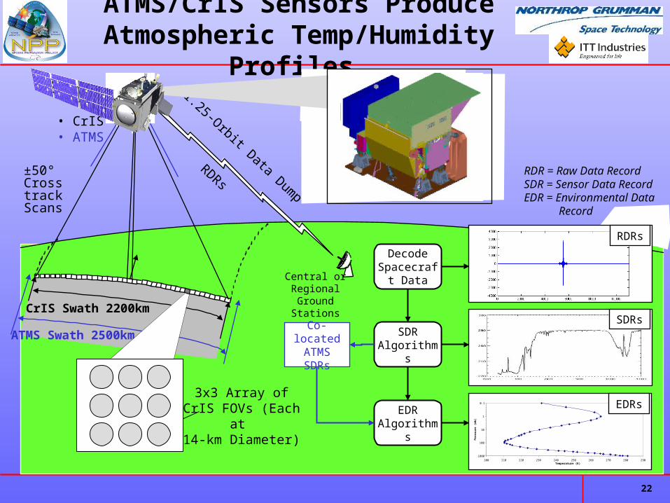
ATMS/CrIS Sensors Produce Atmospheric Temp/Humidity Profiles
CrIS Swath 2200km
RDRs
EDR Algorithms
Decode Spacecraft
Data
SDR Algorithms
±50° Cross track
Scans
• CrIS • ATMS
3x3 Array of CrIS FOVs (Each at
14-km Diameter)
1.25-Orbit Data Dump
Central or Regional Ground
Stations
RDR = Raw Data RecordSDR = Sensor Data RecordEDR = Environmental Data Record
SDRs
RDRs
0.1
1
10
100
1000
200 210 220 230 240 250 260 270 280 290Temperature (K)
Pre
ssu
re (
mb
)
EDRs
ATMS Swath 2500km Co-located ATMS SDRs
23
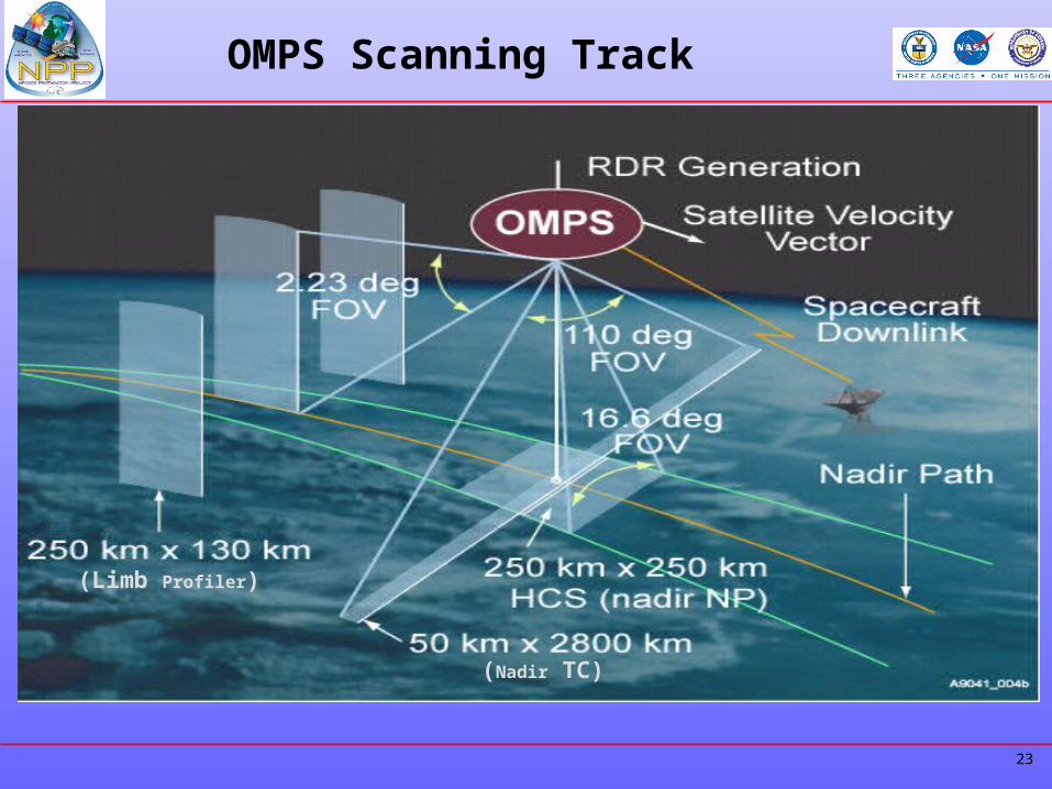
OMPS Scanning Track
(Nadir TC)
(Limb Profiler)
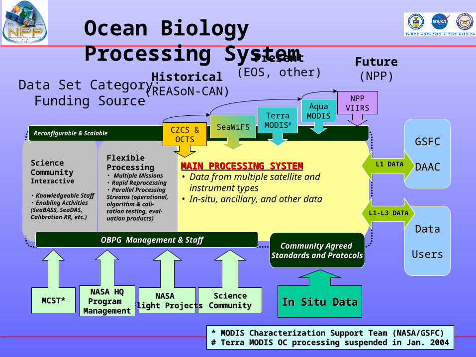
MAIN PROCESSING SYSTEMMAIN PROCESSING SYSTEM• Data from multiple satellite and
instrument types• In-situ, ancillary, and other data
GSFCGSFC
DAACDAACFlexibleFlexibleProcessingProcessing• Multiple MissionsMultiple Missions• Rapid ReprocessingRapid Reprocessing• Parallel ProcessingParallel ProcessingStreams (operational,Streams (operational,algorithm & cali-algorithm & cali-ration testing, eval-ration testing, eval-uation products)uation products)
ScienceScienceCommunityCommunityInteractiveInteractive
• Knowledgeable StaffKnowledgeable Staff• Enabling ActivitiesEnabling Activities(SeaBASS, SeaDAS,(SeaBASS, SeaDAS,Calibration RR, etc.)Calibration RR, etc.)
OBPG Management & StaffOBPG Management & Staff
Reconfigurable & ScalableReconfigurable & Scalable CZCS &OCTS
SeaWiFS
TerraMODIS#
AquaMODIS
NPPVIIRS
ScienceScienceCommunityCommunity
NASA NASA Flight ProjectsFlight Projects
NASA HQNASA HQProgram Program
ManagementManagement
Ocean Biology Processing System
Community Agreed Community Agreed Standards and ProtocolsStandards and Protocols
In Situ DataIn Situ Data
DataData
UsersUsers
L1 DATADATA
L1-L3 DATAL1-L3 DATA
MCST*MCST*
* MODIS Characterization Support Team (NASA/GSFC)* MODIS Characterization Support Team (NASA/GSFC)# Terra MODIS OC processing suspended in Jan. 2004# Terra MODIS OC processing suspended in Jan. 2004
Historical(REASoN-CAN)
Present(EOS, other)
Future(NPP)
Data Set Category:Funding Source