Embed Size (px)
Citation preview
1
Univerzita Karlova v Praze, Přírodovědecká fakulta
Katedra fyzické geografie a geoekologie
Charles University in Prague, Faculty of Science
Department of Physical Geography and Geoecology
Doktorský studijní program: Fyzická geografie a geoekologie
Ph.D. study program: Physical geography and geoecology
Autoreferát dizertační práce
Summary of the Ph.D. Thesis
Step nebo les? Ekologické podmínky vzniku a vývoje
černozemí ve Střední Evropě.
Steppe or woodland? Ecological Conditions of Formation and
Evolution of Chernozems in Central Europe.
RNDr. Barbora Vysloužilová
Školitel/Supervisor: RNDr. Luděk Šefrna, CSc.
Školitel/Supervisor: Prof. Dominique Schwartz
Praha, 2014
2
Abstrakt
Černozemě se staly díky Dokučajevově dizertaci z roku
1883 významné pro počátky pedologie. Geneze černozemí ve
Střední Evropě se dodnes těší velkému zájmu pedologů,
botaniků a paleoenvironmentalistů. Zatímco ve Východní
Evropě byly popsány jako zonální půdy, které jsou typické pro
kontinentální stepi, existují ve Střední Evropě černozemní
oblasti, jež jsou svými klimatickými vlastnostmi
predestinovány pro přítomnost lesních porostů. Předkládaná
dizertační práce si klade za cíl přispět k diskuzi o vzniku
černozemí tím, že pojednává o environmentálních
podmínkách, které byly určující při formování černozemních
půd ve Střední Evropě.
Černozemě se obvykle vyvíjely na spraši, jsou
charakteristické svým mocným povrchovým organickým
horizontem, který přímo přechází do matečné horniny
s vysokým obsahem uhličitanu vápenatého. Organický
materiál procházel díky meziročním klimatickým rozdílům
pomalou polymerizací. Ve Střední Evropě jsou ovšem
klimatické vlastnosti černozemních oblastí odlišné. Zdejší
černozemě se patrně formovaly v klimatických podmínkách,
které převládaly v pozdní době ledové a raném holocénu.
Klimatické nuance sice mohou na regionální úrovni
přispět k osvětlení rozdílů v distribuci „suchých“ černozemí a
„spíše vlhkých“ hnědozemí, ale rozhodně neřeší problematiku
na lokální úrovni, kde při stejných klimatických podmínkách
existují ostré přechody mezi černozemí a hnědozemí. Teorie o
zachování černozemí praví, že zemědělská činnost v neolitu
zabránila jejich přeměnám v další půdy. Tato teorie nabízí
uspokojivé vysvětlení k rozmístění černozemních půd ve
formě mozaiky, kde černozemě alternují s hnědozeměmi či
šedozeměmi.
3
Dizertace se zaměřuje na otázku paměti půd a jejich
organického materiálu. Určitý organický materiál může v půdě
existovat po tisíce let. Je výhradně lokálního původu, a proto
je možné z něj určit vegetaci z doby formování půd. Pro
analýzu půdního organického materiálu je užívána metoda
blízké infračervené spektroskopie (NIRS). Tato metoda
představuje inovativní přínos pro studium
paleoenvironmentálních prvků u černozemí. Mimoto
dizertační práce obsahuje i paleoantrakologickou studii
vybraných pohřbených půd a mikromorfologickou analýzu
katény černozem-hnědozem na malém území (300 m).
Metoda NIRS prokázala, že některé černozemě vznikaly
pod travnatým povrchem. Jiné černozemě mají nedávnou lesní
historii, ale původně se nacházely pod travnatou vegetací.
Nalezeny byly i černozemě s heterogenním organickým
materiálem. Výzkum uhlíku z paleočernozemí z období
pleistocénu a holocénu prokázal přítomnost dřevin.
Mikromorfologická analýza katény černozem-hnědozem
demonstruje, že jsou i černozemě vzniklé z hnědozemí, což
kontrastuje s obvyklými modely degradace černozemí na
hnědozemě.
Tato dizertační práce dokazuje, že vegetace pokrývající
černozemě může být travnaté nebo dřevinaté povahy. Zcela
jistě se černozemě vyvíjely také pod lesem. Výsledky
dizertace jsou v rozporu s převládající hypotézou o tom, že
černozemě vznikají a poté existují výhradně pod stepí.
Klíčová slova: černozem, pohřbené půdy, paleoekologie,
blízká infračervená spektroskopie, Střední Evropa, paměť půd,
pedogeneze, hnědozem
4
Abstract Chernozem became the crucial soil for the beginnings
of soil science through the work of Dokuchaev from 1883.
Since then the genesis of chernozems in Central Europe has
raised many questions among soil scientists, botanists and
paleo-environmentalists. While in Eastern Europe chernozems
have been described as zonal soils, that are typical for
continental steppe and forest-steppe areas, there are areas in
Central Europe which are predisposed by their climatic
characteristics to the presence of woodlands. The goal of this
dissertation is to enrich the discussion about the genesis of
chernozems by restoring the environmental conditions that
were prevalent during the formation of chernozem soils in
Central Europe.
Chernozems are usually developed on loess with a very
thick and dark organic surface which passes directly to a
calcareous horizon. The organic matter underwent a
polymerization in dependence on climate contrasts. However,
in Central Europe, the climatic characteristics of the areas of
chernozems are a bit different. These chernozems are
supposed to have been formed under the climatic conditions
that dominated Central Europe during the Late Glacial and the
Early Holocene.
The climatic nuances may contribute to the explanation
of the differences in distribution of chernozems ("drier") and
luvisols ("more humide") at a regional level, but they are no
help at a local level with the same environmental conditions
where the boundaries between chernozems and luvisols are
very sharp. There is a theory about their persistence that
considers the agriculture since the Neolithic being the reason
for the fact that their progression to other types of soil was
blocked. This theory would explain their distribution in the
form of mosaic, alternating with luvisols and phaeozems.
5
This study is focused on questioning of the memory of
soils and especially of their organic matter. Some soil organic
matter has the ability to persist in soils for thousands of years.
Such organic matter has a purely local origin. That is why it is
possible to reconstruct the vegetation from the period of time
of the formation of soils. There is qualitative near infrared
spectroscopy (NIRS) applied for the analysis of the soil
organic matter. This method is an innovative approach to the
studying of the paleoenvironments of chernozems. This
approach is accompanied by an anthracological study of some
paleosols and of a micromorphological analysis of a catena
chernozem-luvisol on a very local scale (300 m).
The NIRS analysis has proved that some chernozems
developed under grassland. Other chernozems have a recent
forest history, but they had also existed under grassland
vegetation before. There were found some chernozems with a
source of heterogeneous organic material. The charcoals
studies of paleochernozems of the Pleistocene and of the
Holocene have revealed the presence of woods. The
micromorphological analysis of a catena chernozem-luvisol
has shown a chernozem which developed from a luvisol. That
contrasts with the usual models of the degradation of
chernozems into luvisols.
This dissertation confirms that the vegetation cover of
chernozems can be both: grassland or woodland. Certainly,
chernozems also developed under woodland during a period of
time. This result is inconsistent with the prevailing hypothesis
that claims chernozems develop and preserve exclusively
under steppe.
Keywords: chernozem, buried soils, paleoenvironment, near-
infrared spectroscopy (NIRS), Central Europe, soil memory,
pedogenesis, luvisol
6
1. Úvod
Cílem dizertační práce nazvané „Step nebo les?
Ekologické podmínky vzniku a vývoje černozemí ve
Střední Evropě“ je rekonstrukce ekologických podmínek,
které provázely pedogenezi černozemí ve Střední Evropě.
Tato práce je příspěvkem k dlouholeté debatě o vzniku
půdy, která díky doktorské práci Vasila Vasiljeviče
Dokučajeva (1846-1903) stála u vzniku pedologie jako
moderní vědy. K dosud známým informacím o vzniku
černozemí dodává dizertace nové poznatky, získané
jednak „klasickými“ metodami, ale především i využitím
blízké infračervené spektrometrie (NIRS). Dizertační
práce vznikala pod dvojím vedením na Univerzitě ve
Štrasburku a na Univerzitě Karlově v Praze. Tato
jedinečná spolupráce umožnila využití nové
paleoenvironmentalistické metody vyvinuté na
Univerzitě ve Štrasburku na zájmovém území Střední
Evropy.
Ekologické podmínky ovlivňují proces vývoje
půdy. Mezi pedogenetické faktory se řadí klima, matečná
hornina, biologická aktivita, topografie, čas a člověk
(Jenny, 1941). Ekologické podmínky pedogeneze
černozemí ale zůstávají nevyjasněné. První pokusy o
popis ekologických podmínek černozemních oblastí
učinil Dokučajev (1883), jenž černozem popsal jako
typickou půdu stepních oblastí. Toto tvrzení bylo
mnohokrát diskutováno (Ložek, 2004; Lorz et Saile,
2011; Eckmeier et al., 2007; Gehrt et al., 2002; Gerlach
et Eckmeier, 2012). Předmětem debaty bývá nesrovnalost
mezi definicí černozemě jako stepní půdy
7
(FAO/ISRIS/ISSS, 2006, Němeček et al., 2001) a
přítomností černozemě v oblastech, které jsou kvůli svým
ekologickým podmínkám predisponovány k rozvoji lesů
(Ehwald et al., 1999; Vysloužilová et al., 2014).
Černozem je půdní typ, který je oceňován pro svou
vysokou úrodnost. Oblast výskytu černozemí se nápadně
shoduje s oblastí rozšíření neolitické kultury s lineární
keramikou (zvané též Linearbandkeramik LBK) (Kruk,
1980; Demoule et al., 2007). Vznikla tak hypotéza, že
vysoký agronomický potenciál vedl neolitické zemědělce
k tomu, že při osidlování upředňostovali tyto půdy.
Činnost člověka, zemědělce, je považována za hlavní
faktor, který vedl k zachování černozemí ve Střední
Evropě až do dnešních dnů (Ložek, 2004; Schwartz et al.,
in prep.).
Práce si klade za cíl uchopit tuto problematiku
v širokém časovém a prostorovém kontextu. Zájmovým
územím práce je Střední Evropa, jež je území nacházející
se na západním okraji eurasijského černozemního pásu.
Tato oblast leží mimo pás zonálních stepí. Zkoumané
půdy pocházejí z velké části z České republiky,
Slovenska a Maďarska. Další výzkumné vzorky půd
pocházejí z Francie, Polska, Ruska a Ukrajiny.
V minulosti bylo rozšíření černozemí pravděpodobně
rozsáhlejší než dnes. V pleistocénu docházelo ke genezi
černozemí během jeho teplých výkyvů v glaciálech a na
přelomu mezi glaciály a interglaciály (Němeček et al.,
1990; Ložek, 2004), což je doloženo přítomností
pohřbených půd ve sprašových sériích. V holocénu
dochází k pohřbívání černozemí koluvii. To dokládají
pohřbené půdy v oblastech, kde dnes půdní pokryv není
tvořen černozemí. Černozemě, které vytvářejí dnešní
8
půdní pokryv, jsou považovány za relikty z pozdního
pleistocénu a raných fází holocénu, kdy zde panovaly
jiné, sušší a chladnější, klimatické podmínky (Leser et
Maqsud, 1975; Lorz et Saile, 2011; Scheffer et Meyer,
1963). Mechanismus jejich zachovávání dodnes není
dosud zcela znám.
Dosud byly ke studiu paleoekologických podmínek
vzniku černozemí používány palynologické (př. Havinga,
1972; Pokorný, 2005), malakologické (př. Ložek, 2004,
Antoine et al., 2013) a paleobotanické (Barczi et al.,
2009; Andreeva, 2011) analýzy. Kvalitativní aplikace
NIRS však umožňuje studium původního půdního
organického materiálu (Ertlen, 2009), který soustavně
vznikal během celého vývoje půdy. Aplikace NIRS
představuje stěžejní metodu dizertační práce. Metodou
NIRS získaná spektra lze považovat za „otisk prstu“
původu organického materiálu (Palmborg et Nordgren,
1996). Práce představuje první aplikaci metody za
účelem paleoenvironmentalistické rekonstrukce. Součástí
práce je i pedoantrakologická analýza několika
pohřbených černozemí a mikromorfologická analýza
katény černozem-hnědozem.
2. Cíle práce
Cílem dizertační práce je
zrekonstruovat ekologické podmínky vzniku
černozemí ve Střední Evropě pomocí NIRS
(rozlišit stepní a lesní vegetaci),
9
provést pedoantrakologickou studii vybraných
pohřbených půd,
analyzovat katénu černozem-hnědozem za účelem
odhalení odlišností v pedogenetickém procesu
těchto půd ve stejných geografických
podmínkách,
syntetizovat výsledky a porovnat je s výstupy
„klasických“ metod a zhodnotit míru
antropogenního vlivu na pedogenezi černozemí.
3. Materiál a metodika
Stěžejní metoda studie – NIRS – slouží k určování
druhu vegetace, který byl zdrojem půdního organického
materiálu. NIRS měří absorbanci půdního organického
materiálu ve spektrálním rozmezí 1100-2500nm
(spektrometr FT – IR Frontier spectrometer
PerkinElmer). Protože určité frakce půdního organického
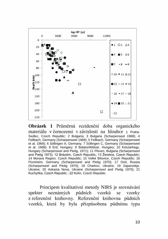
materiálu jsou schopny setrvávat v půdě několik tisíc let
(obrázek 1), lze je považovat za „půdní paměť“ historie
prostředí, kde vznikaly.
10
Obrázek 1 Průměrná rezidenční doba organického
materiálu v černozemi v závislosti na hloubce 1 Praha-
Sedlec, Czech Republic; 2 Bulgaria; 3 Bulgaria (Scharpenseel 1968); 4 Fellbach, Germany (Scharpenseel 1969); 5 Fellbach, Germany (Scharpenseel et al. 1969); 6 Söllingen A, Germany; 7 Söllingen C, Germany (Scharpenseel et al. 1968); 8 Erd, Hungary; 9 Balatonföldvar, Hungary; 10 Köszarhegy, Hungary (Scharpenseel and Pietig, 1971); 11 Pleven, Bulgaria (Scharpenseel and Pietig 1973); 12 Brázdim, Czech Republic; 13 Žeretice, Czech Republic; 14 Morava Region, Czech Republic; 15 Velké Bílovice, Czech Republic; 16 Florsheim, Germany (Scharpenseel and Pietig 1970); 17 Orel, Russia (Scharpenseel and Pietig 1970); 18 Charkov, Ukraine; 19 Zaparoskje, Ukraine; 20 Askania Nova, Ukraine (Scharpenseel and Pietig 1970); 21 Kuchyňka, Czech Republic ; 22 Kolín, Czech Republic.
Principem kvalitativní metody NIRS je srovnávání
spekter neznámých půdních vzorků se vzorky
z referenční knihovny. Referenční knihovna půdních
vzorků, která by byla přizpůsobena půdnímu typu
11
černozemě, doposud neexistovala, a bylo třeba ji
vytvořit. Referenční knihovna se skládá ze vzorků se
známým organickým materiálem. Za tímto účelem jsou
odebírány půdní povrchové vzorky na stanovištích, kde
bylo na základě historických pramenů možné ověřit
stabilitu vegetace za posledních 150 let (Ertlen, 2009).
Černozemě jsou půdy, které se ve Střední Evropě
téměř všechny zemědělsky využívají. Černozemě
vyskytující se pod přirozenou či polopřirozenou stepní
vegetací jsou v dnešní krajině vzácné a vyskytují se jen
v přírodních rezervacích. Tato místa se nacházejí
především v Maďarsku, ale i v České republice, Ukrajině
a Rusku. Černozemě pod lesní vegetací bývají ještě
ojedinělejší. Za účelem naší studie se podařilo najít čtyři
lokality s výskytem černozemě pod lesem. Z tohoto
důvodu byla referenční knihovna lesů doplněna
hnědozemí na spraši pod lesem.
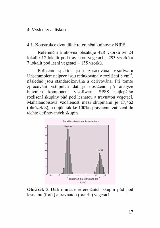
Referenční knihovna je následně porovnána se
vzorky odebranými v půdních profilech půd a
pohřbených půd. Půdy pro tuto studii byly odebírány
především v České republice, na Slovensku a
v Maďarsku, ale také ve Francii, Polsku, na Ukrajině a
v Rusku. Vznikl tak unikátní soubor vzorků, který
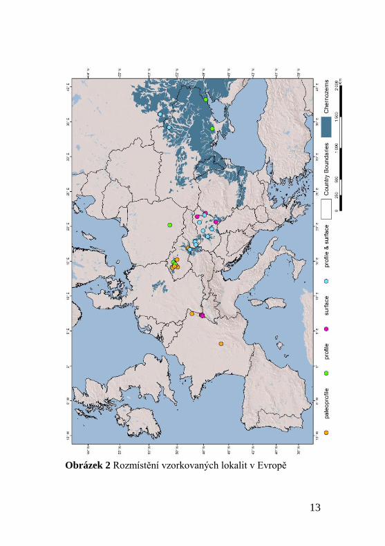
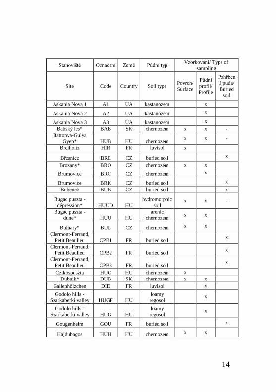
reprezentuje černozemě v Evropě (obrázek 2, tabulka 1).
Každému stanovišti byl při odebrání vzorku přidělen kód,
který jej označuje během celé práce.
Doplňkovou metodou analýzy paleovegetace byla
zvolena pedoantrakologie, tedy extrakce kousků
spálených dřevin z půdy. Pomocí pedoantrakologie je
možné určit dynamiku vegetace na daném stanovišti.
Pedoantrakologická analýza byla provedena ze dvou
12
holocénních pohřbených černozemí v Kolíně a Poplzích a
z půd pohřbených ve sprašové sérii Zeměchy. Výsledky
pedoantrakologické analýzy slouží i k ověření výsledků
z NIRS.
Mikromorfologie půd je metoda určená ke studiu
půdních vlastností, které nejsou patrné
při makroskopickém pozorování půd. K podrobné studii
katény mezi černozemí a hnědozemí byla využita právě
mikromorfologie půd v detailním měřítku, která
umožňuje podrobné studium půdní struktury. Půdní
struktura může odrážet stopy polygenetických
půdotvorných procesů. Výběr lokality pro studium půdní
katény mezi černozemí a hnědozemí byl podmíněn
několika kritérii:
- Přítomností modální černozemě a hnědozemě
v těsném sousedství tak, aby nebylo možné
podmiňovat rozlišnou pedogenezi rozdílným
klimatickým podmínkám.
- Relativně plochým terénem, aby faktory eroze a
akumulace půd mohly být vyloučeny jako
hlavní pedogenetický proces.
Na základě půdních map a terénního průzkumu
byla vybrána lokalita Hrušov.
13
Obrázek 2 Rozmístění vzorkovaných lokalit v Evropě
14
Stanoviště Označení Země Půdní typ Vzorkování/ Type of
sampling
Site Code Country Soil type Povrch/
Surface
Půdní
profil/ Profile
Pohřbená půda/
Buried
soil
Askania Nova 1 A1 UA kastanozem x
Askania Nova 2 A2 UA kastanozem x
Askania Nova 3 A3 UA kastanozem x
Babský les* BAB SK chernozem x x -
Battonya-Gulya Gyep* HUB HU chernozem
x x -
Breiholtz HIR FR luvisol x
Břesnice BRE CZ buried soil x
Brozany* BRO CZ chernozem x x
Brumovice BRC CZ chernozem x
Brumovice BRK CZ buried soil x
Bubeneč BUB CZ buried soil x
Bugac puszta -
dépression* HUUD HU
hydromorphic
soil x x -
Bugac puszta - dune* HUU HU
arenic chernozem
x x
Bulhary* BUL CZ chernozem x x
Clermont-Ferrand,
Petit Beaulieu CPB1 FR buried soil x
Clermont-Ferrand, Petit Beaulieu CPB2 FR buried soil
x
Clermont-Ferrand,
Petit Beaulieu CPB3 FR buried soil x
Czikospuszta HUC HU chernozem x
Dubnik* DUB SK chernozem x x
Gallenhölzchen DID FR luvisol x
Godolo hills - Szarkaberki valley HUGF HU
loamy regosol
x
Godolo hills - Szarkaberki valley HUG HU
loamy regosol
x
Gougenheim GOU FR buried soil x
Hajdubagos HUH HU chernozem x x
15
Homutovsky steppe H1 UA chernozem x
Kolín 1 KOL1 CZ buried soil x
Kolín 2 KOL2 CZ buried soil x
Kolín 3 KOL3 CZ buried soil x
Kopeč-chernozem* KOC CZ chernozem x x
Kopeč-rendzine* KOR CZ rendzina x x
Kuchynka KUC CZ chernozem x
Kursk* KUR RUS chernozem x x
Mezofold -
Belsobarand-
valley* HUM1 HU chernozem
x x
Mezofold -
Belsobarand-valley* HUM2 HU chernozem
x
Mikhajlovska
celina CT UA chernozem x
Mikhajlovska
celina MIK* MIK UA chernozem x x
Młodzawy MD PL chernozem x
Morschwiller-le-
Bas MOR FR buried soil x
Poplze POP CZ chernozem x
Poplze POL CZ buried soil x
Poscaj HUP HU chernozem x
Sainte-Croix-en-Plaine SCD FR buried soil
x
Sarand* HUS HU
arenic
chernozem x
Senec* SEN SK chernozem x x
Stoeffelhag CAR FR luvisol x
Streletsk STR RUS chernozem x
Tard* HUR HU luvic
chernozem x x
Tokaj HUT HU ranker x
Wiwersheim WIW FR buried soil x
Zeměchy ZMC, ZMK CZ buried soil
x
Tabulka 1 Seznam vzorkovaných lokalit
16
Pro lokalitu Kuchyňka a vybrané pohřbené půdy byla
měřena i průměrná rezidenční doba organického
materiálu pomocí radiokarbonového datování. Měření
bylo po dekarbonizaci provedeno v laboratoři v Gif sur
Yvette (Francie) a v Poznani (Polsko).
Celý soubor zkoumaných půd byl zároveň
chemicky a fyzikálně analyzován následujícími
metodami:
- Měřením zrnitostního složení půdy pomocí
laserového granulometru.
- Měřením obsahu CaCO3 na základě měření
objemu CO2 uvolněného při reakci půdního
vzorku s HCl (Bernardův kalcimetr).
- Měřením obsahu uhlíku na základě tří metod.
Celkový organický materiál je orientačně určen
metodou porovnání váhy vzorku před a po
spálení při teplotě 375°C po dobu 16 hodin.
Tato metoda umožňuje odhad množství vzorku
pro měření organického uhlíku metodou
Walkley and Black (1934). Obsah organického
uhlíku je měřen mokrou oxidací dle postupu
Walkley a Black (1934). Celkový uhlík je určen
měřením konduktivity plynů CO2 a NO2
uvolněných při spalování půdního vzorku při
teplotě 1200°C v přístroji Organic Elemental
Analyzer Flash 2000.
- Měření pH, tj. obsahu volných iontů H+, které
jsou adsorbovány v organo-jílovitém komplexu.
17
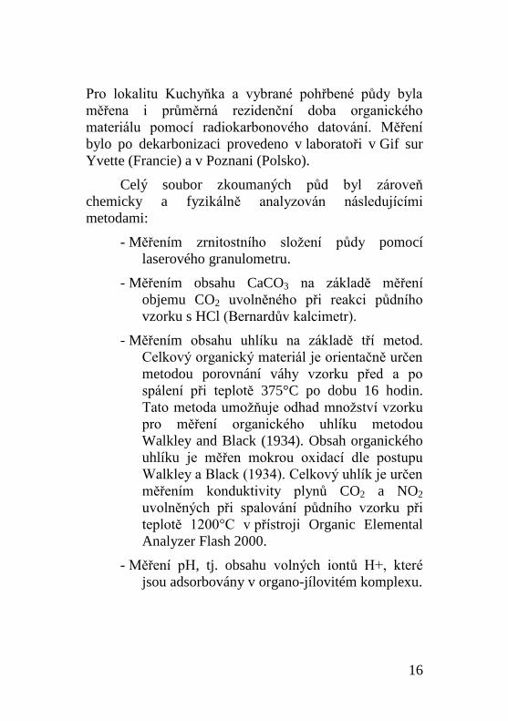
4. Výsledky a diskuse
4.1. Konstrukce dvoudílné referenční knihovny NIRS
Referenční knihovna obsahuje 428 vzorků ze 24
lokalit: 17 lokalit pod travnatou vegetací – 293 vzorků a
7 lokalit pod lesní vegetací – 135 vzorků.
Pořízená spektra jsou zpracována v softwaru
Unscrambler: nejprve jsou redukována v rozlišení 8 cm-1
,
následně jsou standardizována a derivována. Při tomto
zpracování vstupních dat je dosaženo při analýze
hlavních komponent v softwaru SPSS nejlepšího
rozlišení skupiny půd pod lesnatou a travnatou vegetací.
Mahalanobisova vzdálenost mezi skupinami je 17,462
(obrázek 3), a dojde tak ke 100% správnému zařazení do
těchto definovaných skupin.
Obrázek 3 Diskriminace referenčních skupin půd pod
lesnatou (forêt) a travnatou (prairie) vegetací
18
Nejprve bylo ověřeno, že obě populace vzorků jsou
rozlišovány na základě kvalitativních vlastností, tedy na
základě původu vegetace, a nikoli na základě vlastností
kvantitativních, tedy fyzikálně-chemických vlastností
(Ertlen, 2009). Analýzou pH, dále analýzou obsahu
organického C, obsahu CaCO3, pH a zrnitostního složení
bylo zjištěno, že tyto elementy sice ovlivňují vlastnosti
spekter, nejsou ovšem určující pro diskriminaci z
hlediska kvantitativních vlastností zkoumaných skupin
půd.
Vytvořený model půdy pod travnatou vegetací a
půdy pod lesnatou vegetací lze s vysokou mírou
spolehlivosti použít při analýze původu organického
materiálu v půdách a pohřbených půdách (tzv. dvojdílný
model).
Referenční třída půd pod travnatou vegetací se
pohybuje v rozmezí diskriminační funkce -8,9 až -3,1.
Referenční třída půd pod lesnatou vegetací se pohybuje
v rozmezí diskriminační funkce 9,1 až 14,4. Hodnoty,
které se nalézají v přechodném vnitřním intervalu
vymezeného těmito skupinami, tj. -3,1 až 9,1 jsou
interpretovány jako směs heterogenního organického
materiálu obou skupin půd. Podle vývoje výsledku
diskriminační funkce v závislosti na hloubce v profilu je
možné vypozorovat, zde se na stanovišti vyskytovala
stabilní lesostepní vegetace, tzn. hodnoty jsou konstantní,
anebo docházelo ke změně vegetace, tzn. hodnota
vykazuje vývoj v půdním profilu.
19
4.2. Aplikace dvoudílného modelu na půdy
Na základě výsledku aplikace modelu na soubor 26
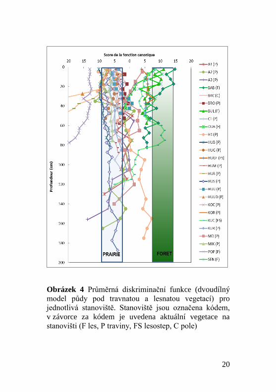
černozemních profilů (obrázek 4) lze pozorovat pět
skupin profilů:
- Půdy s vývojem pouze pod travnatou vegetací
- Půdy se stabilní přechodnou vegetací
- Půdy s komplexním vývojem
- Půdy s travnatou vegetací v minulosti, které jsou
aktuálně pod lesem
- Půdy, které se v minulosti nacházely pod
přechodnou vegetací, ale aktuálně jsou pod vegetací
travnatou
20
Obrázek 4 Průměrná diskriminační funkce (dvoudílný
model půdy pod travnatou a lesnatou vegetací) pro
jednotlivá stanoviště. Stanoviště jsou označena kódem,
v závorce za kódem je uvedena aktuální vegetace na
stanovišti (F les, P traviny, FS lesostep, C pole)
21
Z výsledků vyplývá, že zkoumané půdy v minulosti
fungovaly a vyvíjely se pod travnatou vegetací.
Černozemě, které jsou v současné době pod lesem, se
v minulosti vyskytovaly pod travnatou vegetací. Je
patrné, že černozem má schopnost setrvat i po velmi
dlouhou dobu pod lesem.
4.3. Aplikace dvoudílného modelu na pohřbené půdy
Analýza organického materiálu pohřbených půd
přináší především informaci o vegetaci, která se na
stanovišti vyskytovala v období, kdy byla půda pohřbena,
anebo v období, které pohřbení předcházelo.
Z analýzy vyplývá, že černozemě byly v momentu
pohřbení pod travnatou anebo i lesní vegetací. Analýza
pohřbených půd umožňuje zároveň srovnání výsledků
analýzy NIRS s klasickými metodami.
Například profil POL byl dle Ložka a Smolíkové
(1978) určen jako stepní. Organický materiál v pohřbené
půdě BRE je stepního původu. Podle Ložka (1974) se
tato půda vytvářela pod stepní vegetací. Ve svrchní části
pohřbené půdy dochází ke změně výsledků diskriminační
funkce NIRS. Ložek (1974) popisuje zalesnění
černozemě v atlaniku. Profil KOL je podle dvoudílného
modelu určen jako lesní. V půdě byly nalezeny
makrozbytky spálených uhlíků (Vysloužilová et al.,
2014). Ani v dalších případech nedochází k rozporu mezi
výsledky NIRS a jiných paleoekologických metod.
22
4.4. Pedoantrakologická studie
V rámci práce byly analyzovány uhlíky
z pleistocenních pohřbených půd ze sprašové
série Zeměchy ve spolupráci s L. Dankovou. Dále byly
analyzovány uhlíky ze dvou holocénních pohřbených
černozemí v Kolíně a Poplzích.
Pleistocénní černozemě jsou charakteristické
relativně vysokou antrakomasou, která se pohybuje mezi
93 a 354mg.kg-1
. Nalezené uhlíky pocházejí z jehličnanů,
zpravidla z modřínu a borovice. Holocénní černozemě se
vyznačují nízkou antrakomasou. Obsahují jen malý počet
uhlíků, které jsou mnohdy křehké a obtížně
identifikovatelné. Mezi identifikované druhy v těchto
půdách patří listnaté stromy, především duby a habry,
tedy druhy, které odpovídají potenciální přirozené
vegetaci v regionu výskytu černozemí ve Středních
Čechách (Neuhäuselová, 1998).
Výsledky pedoantrakologické studie naznačují, že
černozemě nejsou jen stepní půdy, že existovaly jistou
dobu svého vývoje i pod lesní vegetací.
4.5. Katéna černozem–hnědozem v Hrušově
Černozem a hnědozem jsou definičně (Němeček et
al., 2001; FAO/ISRIC/ISSS, 2006) rozlišovány různými
podmínkami pedogeneze. Zatímco černozemě jsou
definovány jako stepní půdy suchých podmínek,
hnědozemě se naopak vyvíjejí pod lesem ve vlhčích
podmínkách. Přesto se vyskytují vedle sebe v katéně
Hrušov. V měřítku 300 m se zde nacházejí oba dva typy
půd bez zjevné příčiny. Celkem bylo analyzováno šest
23
půdních profilů: 1 reprezentuje modální černozem, 2
černozemě luvické (černozemě s horizontem Bt) a 3
hnědozem.
Analýza NIRS ukázala, že z pohledu původu
půdního organického materiálu se analyzované půdy
neliší. Dvoudílné rozdělení řadí půdy mezi půdy pod
stabilní travnatou či přechodnou vegetací. Tento výsledek
je překvapivý v tom smyslu, že nepotvrzuje hypotézu, že
vývoj hnědozemě probíhal před zemědělským využitím
pod lesní vegetací.
Při mikromorfologické studii půd této katény byla
zjištěna přítomnost struktur, které naznačují
pedogenetické procesy provázející vznik půd:
- Postupný průběh dvou fází illimerizace. První fázi
prokazují světlé průhledné povlaky
žlutooranžové barvy. Tato fáze odpovídá
přirozené illimerizaci pod lesem. Druhou fázi
dokládají prachovité povlaky hnědé barvy,
které vznikají v půdě destabilizované
zemědělstvím.
- Fáze restrukturalizace anebo úplné destrukce
horizontu Bt v černozemi modální i luvické.
Zároveň v nich nalézáme i žlutooranžové
povlaky, které svědčí o přítomnosti lesa
v minulosti.
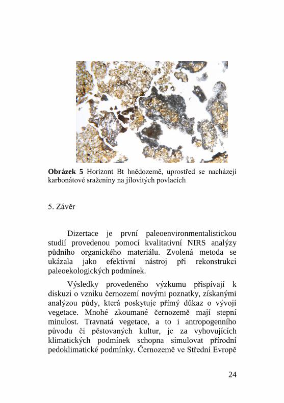
- Fáze rekarbonatizace půdy, která se vyznačuje
vysráženými karbonáty na jílovitých povlacích
v horizontu Bt (obrázek 5). Tato fáze
bezpochyby svědčí o zemědělském využití.
24
Obrázek 5 Horizont Bt hnědozemě, uprostřed se nacházejí
karbonátové sraženiny na jílovitých povlacích
5. Závěr
Dizertace je první paleoenvironmentalistickou
studií provedenou pomocí kvalitativní NIRS analýzy
půdního organického materiálu. Zvolená metoda se
ukázala jako efektivní nástroj při rekonstrukci
paleoekologických podmínek.
Výsledky provedeného výzkumu přispívají k
diskuzi o vzniku černozemí novými poznatky, získanými
analýzou půdy, která poskytuje přímý důkaz o vývoji
vegetace. Mnohé zkoumané černozemě mají stepní
minulost. Travnatá vegetace, a to i antropogenního
původu či pěstovaných kultur, je za vyhovujících
klimatických podmínek schopna simulovat přírodní
pedoklimatické podmínky. Černozemě ve Střední Evropě
25
se podle výsledků kvalitativní NIRS, pedoantrakologie a
mikromorfologie však nevyvíjely čistě pod stepní
vegetací. Černozemě si dokáží zachovat dlouho své
vlastnosti pod lesem. Důležitý výsledek práce
představuje zjištění, že černozem se mohla v důsledku
změny vegetačního pokryvu vyvíjet i z hnědozemí.
6. Použitá literatura
Andreeva, D.B., Leiber, K., Glaser, B., Hambach, U.,
Erbajeva, M., Chimitdorgieva, G.D., Tashak, V., Zech,
W., 2011. Genesis and properties of black soils in
Buryatia, southeastern Siberia, Russia. Quaternary
International 243, 313–326.
doi:10.1016/j.quaint.2010.12.017
Antoine, P., Rousseau, D.-D., Degeai, J.-P., Moine, O.,
Lagroix, F., kreutzer, S., Fuchs, M., Hatté, C., Gauthier,
C., Svoboda, J., Lisá, L., 2013. High-resolution record of
the environmental response to climatic variations during
the Last Interglacial–Glacial cycle in Central Europe: the
loess-palaeosol sequence of Dolní Věstonice (Czech
Republic). Quaternary Science Reviews 67, 17–38.
doi:10.1016/j.quascirev.2013.01.014
Barczi, A., Golyeva, A.A., Peto˝, Á., 2009.
Palaeoenvironmental reconstruction of Hungarian
kurgans on the basis of the examination of palaeosoils
and phytolith analysis. Quaternary International 193, 49–
60. doi:10.1016/j.quaint.2007.10.025
Demoule, J.-P., Cottiaux, R., Dubouloz, J., Giligny, F., Jallot,
L., Manolakakis, L., Sénépart, I., 2007. La révolution
néolithique en France, Archéologie de France. Editions
La Découverte, Paris.
26
Dokuchaev, V.V., 1883. Russkij Cernozem. Sankt Petersburg.
Eckmeier, E., Gerlach, R., Gehrt, E., Schmidt, M.W.I., 2007.
Pedogenesis of Chernozems in Central Europe — A
review. Geoderma 139, 288–299.
doi:10.1016/j.geoderma.2007.01.009
Ehwald, E., Jäger, K.-D., Lange, E., 1999. Das Problem Wald
- Offenland im zirkumherzynen Trockengebiet vor der
neolithischen Besiedlung sowie die Entstehung der
zirkumherzynen Schwarzerden., in: Frühe Nutzung
Pflanzlicher Ressourcen. Internationales Symposium
Duderstedt. Hamburger Werkstattreihe Zur Archäologie.
Internationales Symposium Duderstedt., Lit, Hamburg,
pp. 12–34.
Ertlen, D., 2009. Archivage pédologique et dynamique
environnementales. Université de Strasbourg, Strasbourg.
FAO, ISRIC, ISSS, 2006. World reference base for soil
resources 2006. A framework for international
classification, correlation and communication. Food and
agriculture organization of the United nations, Rome.
Gehrt, E., Geschwinde, M., Schmidt, M.W.I., 2002.
Neolithikum, Feuer und Tschernozem - oder: Was haben
die Linienbandkeramiker mit der Schwarzerde zu tun?
Archäologisches Korrespondenzblatt 21–30.
Gerlach, R., Eckmeier, E., 2012. Prehistoric land use and its
impact on soil formation since Early Neolithic. Examples
from the Lower Rhine area. Journal for Ancient Studies
3, 11–16.
Havinga, A.J., 1972. A palynological investigation in the
pannonian climate region of lower Austria. Review of
Palaeobotany and Palynology 14, 319–352.
doi:10.1016/0034-6667(72)90025-5
27
Kruk, J., 1980. The Neolithic settlement of southern Poland,
illustrée. ed. British Archaeological Reports.
International Reposts 93., Oxford.
Leser, H., Maqsud, N., 1975. Spätglaziale bis frühhlozäne
Steppenbodenbildung und Klimaentwicklung im
südlichen Rheinhessischen Tafel- und Hügelland.
Eiszeitalter und Gegenwart 26, 118–130.
Lorz, C., Saile, T., 2011. Anthropogenic pedogenesis of
Chernozems in Germany? – A critical review.
Quaternary International 243, 273–279.
doi:10.1016/j.quaint.2010.11.022
Ložek, V., 1974. Příroda Českého krasu v nejmladší
geologické minulosti. Bohemia Centralis 3, 175–194.
Ložek, V., 2004. Středoevropské bezlesí v čase a prostoru III.
Historie lesa a bezlesí v kvartéru. Ochrana přírody 59,
71–78.
Ložek, V., Smolíková, L., 1978. Die nacheiszeitlichen
Bodenabfolgen von Poplze und Štětí als Beleg der
Boden- und Landschaftentwicklung im Böhmischen
Tschernosemgebiet, in: Beiträge zur Quatär- und
Landscahftsforschung Festschrift zum 60. Geburtstag
von Julius Fink. Verlag F. Hirt, Wien, pp. 531–549.
Němeček, J., Macků, J., Vokoun, J., Vavříček, D., Novák, P.,
2001. Taxonomický klasifikační systém půd ČR. ČZU
Praha a VÚMOP Praha, Praha.
Němeček, J., Smolíková, L., Kutílek, M., 1990. Pedologie a
paleopedologie. Academia, Praha.
Neuhäuselová, Z., 1998. Mapa potencionální přirozené
vegetace České republiky - Map of potential Natural
Vegetation of the Czech Republic.
Palmborg, C., Nordgren, A., 1996. Partioning the variation of
microbial measurments in forest soils into heavy metal
28
and substate quality dependent parts by use of near
infrared spectroscopy and multivariate statistics. Soil
Biology and Biochemistry 26, 711–720.
Pokorný, P., 2005. Role of man in the development of
Holocene vegetation in Central Bohemia. Preslia 77,
113–128.
Scharpenseel, H.W., Pietig, F., 1970. University of Bonn
natural radiocarbon measurements III. Radiocarbon 12,
19–39.
Scharpenseel, H.W., Pietig, F., 1971. University of Bonn
natural radiocarbon measurements IV. Radiocarbon 13,
189–212.
Scharpenseel, H.W., Pietig, F., 1973. University of Bonn
natural radiocarbon measurements V. Radiocarbon 15,
13–41.
Scharpenseel, H.W., Pietig, F., Tamers, M.A., 1968. Bonn
Radiocarbon Measurements I. Radiocarbon 10, 8–28.
Scharpenseel, H.W., Pietig, F., Tamers, M.A., 1969.
University of Bonn Natural Radiocarbon Measurements
II. Radiocarbon 11, 3–14.
Scheffer, F., Meyer, B., 1963. Berührungspunkte der
archäologischen und bodenkundlichen Forschung. Neue
Ausgrabungen und Forschungen in Niedersachsen 1, 1–
18.
Schwartz, D., Ertlen, D., Davtian, G., Vysloužilová, B., n.d.
Les sols LBK et leur fertilité. Incidences sur le
développement agricole et la répartition des populations
rubanées (Rapport OBRESOC - Tache 7).
Vysloužilová, B., Danková, L., Ertlen, D., Novák, J.,
Schwartz, D., Šefrna, L., Delhon, C., Berger, J.-F., 2014.
Vegetation history of chernozems in the Czech Republic.
29
Vegetation History and Archaeobotany 23, 97–108.
doi:10.1007/s00334-014-0441-7
Walkey, A., Black, I.A., 1934. An examination of the
Degtjareff method for determining organic carbon in
soils: Effect of variations in digestion conditions and of
inorganic soil constituents. Soil Science 63, 251–263.
30
1. Introduction
The aim of the thesis called “Steppe or woodland?
Ecological Conditions of Formation and Evolution of
chernozems in Central Europe” is to reconstruct the
ecological conditions which prevailed during the
pedogenesis of chernozems in Central Europe. This
thesis contributes to a long discussion about the
formation of chernozems. Chernozem soil was standing
at the beginning of pedology as a modern science. The
thesis introduces new facts and results that were reached
with the “classical” methods. But above all, there are new
facts and results from the use of the near infrared
spectrometry (NIRS). The cooperation between Charles
University in Prague and University of Strasbourg has
enabled a close focus on the region of Central Europe
using the new method NIRS from Strasbourg as a
paleoenviromental tool.
The ecological conditions influence the processes
of pedogenesis. The pedogenic factors are climate,
geological subsoil, biological activity, topography, time
and the man (Jenny, 1941). Nevertheless, the ecological
conditions of the pedogenesis of chernozems are still
unclear. First attempts to describe the ecological
conditions of chernozems regions were done in the 19th
century, when Dokuchaev (1883) defined the chernozem
as a typical soil of a steppe environment. The definition
of Dokuchaev has been frequently discussed (Ložek,
2004; Lorz et Saile, 2011; Eckmeier et al., 2007; Gehrt et
al., 2002; Gerlach et Eckmeier, 2012). The crucial point
of these discussions is the discrepancy between the
31
definition of chernozem as a steppe soil and the presence
of chernozems in the regions which are predisposed to
the growth of woodlands (Ehwald et al., 1999;
Vysloužilová et al., 2014).
Chernozem is a soil type that is appreciated for its
high agronomical potential. The regions of chernozems
correspond to the areas of expansion of the Neolithic
culture LBK (Kruk, 1980; Demoule et al., 2007). There is
a hypothesis that the high soil fertility was the reason
why the Neolithic farmers settled in the regions of
chernozems and that farming has contributed to the
persistence of chernozems in Central Europe until now
(Ložek, 2004; Schwartz et al., in prep.).
The aim of the thesis was to research on this
problematic in a large temporal and spatial context.There
is a focus on Central Europe – the most occidental part of
the Eurasian chernozem belt. Central Europe lies outside
the zonal steppe area. The majority of the tested soils
come from the Czech Republic, Slovakia and Hungary.
The other soils were sampled in France, Poland, Russia
and Ukraine. In the past, the spatial area of chernozems
was probably larger than today. In the Pleistocene, the
chernozems developed during the warmer deviations of
glacial periods and during the changes between glacial
and interglacial periods (Němeček et al., 1990; Ložek,
2004). This fact is proved by the buried soils in the series
of loess. In the Holocene, some chernozems were buried
by colluvium. There are buried chernozems in the regions
where the pedological cover is not formed by
chernozems today. The chernozems that are forming the
current pedological cover are considered to be a relic
from the late Pleistocene and the early Holocene, because
32
the climate conditions in these periods were drier and
colder (Leser et Maqsud, 1975; Lorz et Saile, 2011;
Scheffer et Meyer, 1963). The mechanism of their
persistence until now has not been discovered yet.
So far, the paleoenvironmental conditions of
chernozems have been derived from the palynological (e.
g. Havinga, 1972; Pokorný, 2005), malacological (e. g.
Ložek, 2004, Antoine et al., 2013) and paleobotanical
(Barczi et al., 2009; Andreeva, 2011) evidence. The
NIRS enables the study of the soil organic matter (Ertlen,
2009). The NIRS is the key method of the study. The
spectra can be considered as a “finger print” of former
vegetation (Palmborg et Nordgren, 1996). The thesis
represents the results of the first application of the NIRS
for a paleoenvironmental reconstruction. The thesis also
includes a pedoanthracological study of buried
chernozems and a micromorphological analysis of the
catena chernozem-luvisol.
2. Goals of the study
This study has following goals:
The reconstruction of the ecological conditions of
the formation of pedogenesis in Central Europe
by the application of the NIRS (Differences
between grassland and woodland vegetation).
The pedoanthracological analysis of some buried
soils.
33
The analysis of the catena chernozem-luvisol in
order to look for differences in the pedogenetic
processes in the same geographical conditions.
The synthesis of new results and the comparison
of results from classical methods. The evaluation
of the degree of the anthropic impact on the
pedogenesis of chernozems.
3. Material and methods
The key method of the study - NIRS serves to
evaluate the type of vegetation which became source of
the soil organic matter. NIRS measures the absorbance of
the soil organic matter (SOM) in the range between
1100-2500nm (spectrometer FT-IR Frontier spectrometer
PerkinElmer. Some fractions of the SOM are able to
reside some thousands of years (figure 1; page 10). We
can consider the SOM as a „soil memory“which
evidences the vegetation history of environment where
they have been formed.
The princip of qualitative NIRS is the comparison of
spectra of soil samples from the reference library with the
samples with unknown organic matter. A reference
library of soil samples appropriated to the chernozems
has not existed so far and it was necessary to create it.
The reference library must be created from the samples
with the SOM of known origin. In this objective the
surface soil samples are collected at the sites where it
was possible to verify in the historical documents the
34
stability of vegetation for at least the last 150 years
(Ertlen, 2009).
Chernozems are soils which are nearly all exploited
for agriculture in Central Europe. Chernozems under
natural or seminatural vegetation are very rare in today’s
landscape and they are found only in the natural
protected areas. These sites were detected in before all in
Hungary but in the Czech Republic, Ukraine and Russia
as well. Chernozems under forest vegetation are even
more exceptional. In the aim of this study we succeeded
to find four sites of chernozem under forest. This is why
the reference library was completed by samples of
luvisols formed on loess found under woodland.
As the next step the reference library is compared
with the samples collected in the profiles of soils and
buried soils in the Czech Republic, Slovakia, Hungary,
France, Poland, Ukraine and Russia. A unique
assemblage of soil samples was emerged. It represents
the chernozems in Europe (figure 2, page 13; table 1 page
14). Each site was labeled by a code which accompanies
the samples during the whole work from sampling to the
interpretation.
Pedoanthracology was chosen as an additional tool
to the analysis of paleovegetation. Pedoanthracology is a
method of botanical determination of charcoals extracted
from the soil. It serves to determinate the dynamics of
vegetation at the site. The pedoanthracological analysis
was preceded at two sites with a chernozem buried in the
Holocene found in Kolin and in Poplze and in the buried
soils in the loess series of Zemechy. The results
35
pedoantrhacological analyses serve as a comparison to
validation of the results of NIRS.
Soil micromorphology is a method to study of the
pedological features which are not obvious during
observation at the macroscopic scale. The
micromorphology was used for analysis of catena
between chernozem and luvisol at a detailed scale. It
enables the study of soil structure which may reflect
traces of polygenetic pedogenetic processes. The choice
of the site for the study of catena was conditioned by
these criteria:
- The presence of chernozem and luvisols in the
near neighborhood; so the presence of a
different soil type is not caused by different
climate conditions;
- A relatively flat terrain, so the processes of
erosion and accumulation can be exluded.
Finally the site of Hrušov was chosen based on
pedological maps and field survey.
At the site of Kuchynka and selected buried soil the
mean residence time of the SOM was measured. The
measurement was taken in the laboratories of Gif sur
Yvette (France) and Poznan (Poland).
The assemblage of studied soils was analyzed for
chemical and physical properties:
- The granulometry measurement was taken by
laser granulometry.
- The evaluation of the content of CaCO3 by
measurement of gas released during the
36
reaction of the soil sample and HCl (Bornard
calcimeter).
- The evaluation of content of C is based on three
methods. The total organic matter is estimated
by the lost during the burning on 375°C during
16 hours. This method is used for estimation of
the amount of soil sample necessary for the
analysis of organic C by Walkley and Black
(1934). The content of organic matter is
evaluated by wet oxidation (Walkley and
Black, 1934). The total C is evaluated by
measurement of the conductivity of gases CO2
a NO2 released during the combustion of soil
sample at the temperature of 1200°C in the
machine Organic Elemental Analyzer Flash
2000.
- Measurement of pH (potential of hydrogen)
which reflects the acidity or basicity of aqueous
solution of soil.
4. Results and discussion
4.1. Construction of two-sided NIRS reference library
The reference library contains 24 sites – 428 of
samples: 17 sites under grassland vegetation – 293
samples and 7 sites under woodland vegetation – 135
samples.
The acquired spectra are treated in the software
Unscrambler: firstly the spectra are reduced to the
37
resolution of 8 cm-1
, and then they are standardised and
derived. The desired result of the analysis of principle
components (software SPSS) is the most important
discrimination between woodland and grassland
vegetation which was reached owing to these treatments.
The achieved Mahalanobis distance between the two
groups is 17,462 (figure 3, page 17). 100% of samples
are classed correctly into these two groups.
At the beginning it was necessary to verify that the
two groups of soil samples are distinguished based on the
origin of the SOM. It was proved that the physical and
chimical properties (pH, CaCO3 and C contents, and the
particle size distribution) are not a desicive factor during
the discrimination of classes.
The two-sided model of grassland and woodland
soils can be applied with a high degree of confidence on
the studied soils and buried soils.
The reference class of soils under grassland
vegetation varies in the range of scores between -8,9 and
-3,1. The reference group of woodland soils varies in the
range of scores between 9,1 and 14,4. The values which
are found in the intermediary values, between -3,1 and
9,1 is interpreted like a mixture of SOM coming from the
two classes. According to the evolution of the scores in
dependence on the depth it is possible to observe if there
was a stable wooden steppe vegetation (the values are
constant) or if there was a change from one type of
vegetation to another (the values change in the soil
profile).
38
4.2. Application of the two-sided model on soils
The two-sided model was applied on 26 of soil
profiles of soils, mostly chernozems (figure 4, page 20).
There are 5 groups of soils:
- Soils with a grassland history;
- Soils with a history of a stable intermediary
vegetation;
- Soils with a complex evolution;
- Soils with a grassland history which are currently
present under a grassland vegetation;
- Soils with intermediary vegetation in the past
which are currently present under a grassland
vegetation.
The results show that the analysed soils have
developed under grassland vegetation. Chernozems
which are currently present under woodlands were
covered by the grassland vegetation in the past. It is
obvious that the chernozem is able to persist during a
long time under woodland.
4.3. Application of two-sided model on buried soils
The analysis of the SOM of the buried soil brings
the information about the former vegetation in the
moment of burying of the soil or in the period of time
that preceded the burying.
39
The results of analysis by NIRS show that the
chernozem occurred under grassland or woodland
vegetation. The analysis of buried soils enables the
comparison of results of the NIRS with other
paleoenvironmental proxies.
For example the buried soil of POL was according
Ložek et Smolíková (1978) determined as a steppe soil.
The SOM of the buried soil of BRE is also of steppe
origin. According to Ložek (1974) the soil was formed
under steppe vegetation. There is a deviation of the
discriminant function at the top of the buried soil. Ložek
(1974) describes forestation of this chernozem in
Atlantic. The soil of KOL is defined by the two-sided
model as a woodland soil. At the same time there were
some charcoals found in the soil (Vysloužilová et al.,
2014). The other analysed soils show no major
contradiction of the results of NIRS and other
paleoecological methods.
4.4. Pedoanthracological study
The charcoals from Pleistocene buried soils were
extracted and analysed in cooperation with L. Dankova.
As well there were some charcoals extracted from two
Holocene buried soils in Kolin and Poplze as well.
The Pleistocene buried chernozems are
characteristic by a relative high anthracomasse which
varies between 93-354 mg.kg-1
. The extracted charcoals
come from coniferous tree species, larches and pines.
The Holocene buried soils are marked by a low
anthracomasse. They contain a very low number of
40
charcoals, which are often fragile and difficult to
identify. The extracted charcoals were identified as
coming from deciduous tree species, mostly oaks and
hornbeams. These species correspond to the potential
natural vegetation of the chernozem regions of Central
Bohemia (Neuhäuselová, 1998).
The results of the pedoanthracological study
indicate that the chernozems are not only steppe soils.
Certainly they have existed during a period of time under
the woodland vegetation.
4.5. Catena chernozem-luvisol in Hrušov
Chernozems and luvisols are by definition
(Němeček et al., 2001; FAO/ISRIC/ISSS, 2006)
distinguished by different conditions of pedogenesis.
Whereas chernozems are defined as steppe soil of dry
regions, luvisols are defined as soils which develop under
forest in more humid regions. Nevertheless the both soil
type are found one next to each other in the catena of
Hrušov. The both soil types are present at the same field
at the distance of 300m without an obvious reason. There
were six profiles analyzed: 1 represents a haplic
chernozem, 2 chernozems luvic (chernozem with a BT
horiozon) and 3 profiles luvisols.
The NIRS analysis shows that from the point of
view of origin of SOM there is no difference between the
analysed soils. The two-sided model determines the
history of all the soils of catena as a stable grassland or
intermediary vegetation. This is a surprising result
because it does not confirm the hypothesis of a longer
41
forest history of luvisols before the agricultural
exploitation of the soils.
The micromorphological study of the soils of
catena revealed the presence of structures that indicate
pedogenetical processes which accompanied the
evolution of soils during their evolution:
- The two phases of illuviation: the first phase is
documented by light transparent coatings of
yellow-orange color. This phase correspond the
natural illuviation under forest. The second
phase is evidenced by pulverous dark brown
coatings which are usually formed in the soil
destabilized by agriculture.
- The phase of restructure or destruction of the
horizon BT in both the chernozems haplic and
luvic. At the same time there are yellow-orange
coatings which document the presence of forest
in the past.
- The phase of recarbonatation of the soils which is
pronounced by the precipitations of carbonates
on the clay coatings in the BT horizon (figure 5,
page 24). This phase is a clear evidence of the
agricultural exploitation.
5. Conclusion
The thesis presents the first paleoenvironmental
study that was made by using the qualitative NIRS of the
42
soil organic matter. This method has proved to be an
efficient tool for the paleoenvironmental reconstruction.
The results of the thesis contribute to the discussion
about the pedogenesis of chernozems. There are
introduced new facts about the evolution of vegetation.
The explored chernozems have a steppe past. The
grassland vegetation – even of an anthropic origin or
culture – is under suitable climatic conditions able to
simulate the pedoclimate conditions that are convenient
for the pedogenesis of chernozems. According to the
results of the NIRS, the pedoanthracology and the
micromorphology, the chernozems of Central Europe are
able to keep the features of chernozems for a very long
time under the woodland vegetation. A crucial point of
this thesis is the result that chernozems could have
developed from luvisols as a result of a change of the
vegetation cover.
Figure captions
Figure 1 Mean residence time of the soil organic
matter of chernozems in dependence to the depth (1 Praha-
Sedlec, Czech Republic; 2 Bulgaria; 3 Bulgaria (Scharpenseel 1968); 4 Fellbach, Germany (Scharpenseel 1969); 5 Fellbach, Germany (Scharpenseel et al. 1969); 6 Söllingen A, Germany; 7 Söllingen C, Germany (Scharpenseel et al. 1968); 8 Erd, Hungary; 9 Balatonföldvar, Hungary; 10 Köszarhegy, Hungary (Scharpenseel and Pietig, 1971); 11 Pleven, Bulgaria (Scharpenseel and Pietig 1973); 12 Brázdim, Czech Republic; 13 Žeretice, Czech Republic; 14 Morava Region, Czech Republic; 15 Velké Bílovice, Czech Republic; 16 Florsheim, Germany (Scharpenseel and Pietig 1970); 17 Orel, Russia (Scharpenseel and Pietig 1970); 18 Charkov, Ukraine; 19 Zaparoskje, Ukraine; 20 Askania Nova, Ukraine (Scharpenseel and Pietig 1970); 21 Kuchyňka, Czech Republic ; 22 Kolín, Czech Republic (this study).
43
Figure 2 Distribution of sampling sites in Europe
Figure 3 Discrimination of reference groups of soils
under the woodland vegetation and under the grassland
vegetation
Figure 4 The average of the discriminate function
(a two-side model under the grassland vegetation and
under the woodland vegetation) for each site. The sites
are labeled with a code. In the brackets, there is a note to
the current vegetation (F woodland, P grassland, FS
wooded steppe, C culture)
Figure 5 BT horizon of a luvisol. In the middle of
the photo, there are carbonate precipitation on the
argilans
Table 1 List of sampling sites
6. References (see page 21)
44
Curriculum vitae
Vzdělání/ Education
1996-2004 Gymnázium Čs. Exilu 669, Ostrava-
Poruba
2004-2007 Bakalářský program Geografie a
kartografie, Přírodovědecká fakulta
Univerzity Karlovy
2007-2010 Magisterský program Fyzická geografie a
geoekologie, Přírodovědecká fakulta
Univerzity Karlovy
2010 Jazyková zkouška DALF úroveň C1
2010 - Doktorát pod dvojím vedením za podpory
Stipendia francouzské vlády: souběžné
studium doktorského programu Fyzická
geografie a geoekologie (Přírodovědecká
fakulta Univerzity Karlovy) a programu
Géographie Ecole Doctorale STU
413Université de Strasbourg (Laboratoire
Image, Ville, Environnement, Faculté de
Géographie et d‘Aménagement)
2010 - Collège Doctorale Européen: Multicultural
European Programme
2012 Státní doktorská zkouška, rigorózní řízení,
Přírodovědecká fakulta Univerzity
Karlovy
45
Seznam publikací / Selected publications
Vysloužilová, B., Ertlen, D., Šefrna, L., Rué, M.,
Campaner, A., Viragh, K., Novak, T. & Schwartz, D.:
Investigation of vegetation history of the chernozem
buried in the Holocene with the method of near-infrared
spectroscopy (NIRS) – accepted in Quaternary
International. DOI 10.1016/j.quaint.2014.07.035.
Vysloužilová, B., Danková, L., Ertlen, D., Novák, J.,
Schwartz, D., Šefrna, L., Delhon, C., Berger, J.-F., 2014.
Vegetation history of chernozems in the Czech Republic.
Vegetation History and Archaeobotany. Vol. 23, 97-108
DOI 10.1007/s00334-014-0441-7.
Schwartz, D.; Ertlen, D.; Davtian, G.; Berger, J-F.,
Vyslouzilova, B. : LBK soils and their fertility levels.
Implications on the agriculture development and the
population distribution in Review, submitted in Springer
Verlag.
Vysloužilová, B., Kliment, Z., 2012. Modelování
erozních a sedimentačních procesů v malém povodí.
Geografie 117, 170–191.
Kliment, Z., Langhammer, J., Kadlec, J., Vysloužilová,
B. 2012. Present changes in water soil erosion hazard and
the response suspended sediment load. In: Die Elbe und
ihre Sedimente, Hamburg (Ch. Wolf Eds.),
Programmkomitee des Magdeburger
Gewässerschutzseminars p. IKSE, Hamburg, 152-154.
Kadlec, J., Kliment, Z., Vysloužilová, B. (2008): Erozní
ohrožení a jeho změny v povodí Opavy po soutok s
46
Moravicí. In: Langhammer: Údolní prostor jako prostor
ovlivňující prostor a následky povodní. KFFG,
Přírodovědecká fakulta, UK. Praha, s. 159-168.
Závěrečné práce/ Thesis
Vysloužilová, B. (2010): Hodnocení erozních procesů
s využitím modelů WaTEM/ SEDEM a USPED.
Diplomová práce, Přírodovědecká fakulta UK. Praha 138
s. (Master thesis).
Vysloužilová, B. (2007): Erozní ohrožení půd v horním
povodí Opavy. Bakalářská práce. Přírodovědecká fakulta
UK. Praha 60 s. (Bachelor thesis).
Příspěvky na konferencích/ Conference communications
7/2014 12ème
Journées d’Etude des Sols,
Chambery, France
Froehlicher L., Ertlen D., Vysloužilová B., Schwartz D. :
L’apport des colluvions agricoles dans la reconstitution
des dynamiques paysagères à partir de la méthode de la
Spectroscopie dans le Proche Infrarouge (SPIR)
qualitative (oral communication)
5/2014 European Geosciences Union
General Assembly 2014, Vienne,
Austria
Kliment, Z., Langhammer, J., Kadlec, J. and
Vysloužilová, B. Present changes in water soil erosion
47
hazard and the response to suspended sediment load in
the Czech landscape (poster)
3/2014 "Sols et structures en creux :
pourquoi faire ? Modes
d’approche et interprétations de
« sols » anthropisés et de fosses en
Nord-Pas de Calais, comparaisons
utiles". Villeneuve d'Ascq, France.
Ertlen, D.: Schwartz, D.; Vysloužilová, B.; Froehlicher,
L., Gebhardt, A., Schneider, N.. Sols et paléosols
anthropisés: approches nouvelles (oral communication)
8/2013 Paleosols, Pedosediments and
Landscape Morphology as
Environemental Archives XIIth
International Symposium and
Field Workshop on Paleopedology.
Kursk, Russia.
Vysloužilová B., Schwartz D., Šefrna, L. Ertlen D.,
Dreslerová D.: Pedogenesis od chernozems in Central
Europe (oral communication)
10/2012 Magdeburger
Gewässerschutzseminar 2012,
Hamburg, Germany
Kliment, Z., Langhammer, J., Kadlec, J., Vysloužilová,
B.: Present changes in water soil erosion hazard and the
response to suspended sediment load (poster)
7/2012 Farming in the forest. Schöntal,
Germany
48
Ertlen, D., Vysloužilová, B., Delhon, C., Berger, J.-F.,
Schwartz, D., Šefrna, and L.: Investigation of soils and
paleosoils in Central Europe in order to understand better
the relationship between the Neolithic farmers and their
landscapes (oral communication)
7/2012 Eurosoil 2012. Bari, Italy
Vysloužilová, B., Dreslerová, D., Ertlen, D., Schwartz,
D., Šefrna, L.: Is chernozem a relic of steppe vegetation?
(poster)
3/2012 11èmes Journées d’étude des Sols,
Versailles
Vysloužilová, B., Schwartz, D., Šefrna, L., Ertlen, D.,
Dreslerová, D., Jelenska, M.: La pédogénèse des
chernozems et des sols bruns lessivés en Europe Centrale
(oral cummunication)
12/2012 Journée des doctorants ED STUE,
Strasbourg
Vysloužilová, B., Schwartz, D., Šefrna, L., Ertlen, D.,
Dreslerová, D., Jelenska, M.: La pédogénèse des
chernozems et des sols bruns lessivés en Europe Centrale
(oral communication)
11/2011 Journée des doctorants ED STUE,
Strasbourg
Vysloužilová, B., Schwartz, D., Šefrna, L., Ertlen, D.: La
pédogénèse des chernozems et des luvisols en Europe
Centrale (poster)