Embed Size (px)
Citation preview

XXVth Conference of the Danubian Countries. 16-17 June 2011 – Budapest, Hungary
1
VULNERABILITY AND PROTECTION OF BANK-FILTERED WATER RESOURCES
ALONG THE HUNGARIAN DANUBE
Károly Gondár - Katalin Gondár-S�regi - Éva Kun – Katalin Székvölgyi László Weiser
SMARAGD-GSH Ltd., H-1114 Budapest Villányi út 9. www.smaragd.hu, e-mail: [email protected],
Abstract The settlements along the Danube river in Hungary are mostly supplied by bank-filtered water. The most significant bank filtered waterworks are situated in the vicinity of Budapest, which supply two million inhabitant. Beside the actual sources of drinking water supplies there are many perspective sources of bank-filtered water supply. With our poster we would like to draw attention to the importance of the protection of these source of water supplies. Our company attends to the large scale action programme relating to the vulnerable active and perspective sources of drinking water supply. The protection zones of seven operating (Leányfalu, Budaújlak, Nagymaros, Dunakeszi, Balpart I, Balpart II, Margitsziget) and three perspective (Váli-víz, Bogyiszló-Fadd, Solti-sziget) source of water supply were designated as the main contractor. KEY WORDS: bank-filtered water resources, protective zones
Introduction 40% of the water supply is originated from bank-filtered vulnerable water resources of Quaternary gravel beds of big rivers, mainly Danube, in Hungary. As stated by law 123/1997.(VII. 18.) (on water supply protection) definition of the bank-filtered water supply is the following: subsurface water resource near surface water where more than 50% of the exploited water derives from recharge from the surface water. In case of bank-filtered water supplies, 50-90% of the exploited water is derived from surface water. For this reason quality of the surface water, state of the river bed, possible contamination of havaria character and other potential contamination sources in the background of the water supply (i.e. land use and human activities) significantly influence the quality of the exploited water. According to the results of the investigations one can recognize that efficiency of bank-filtering and exploitable water quantity is diverse in the different sections of the Danube river bed that mostly generated by the geological background and rate of colmation of the gravel bed. Owing to the investigation of relationship between surface and subsurface waters, research on bank-filtered water resources requires application of special methods. Based on our experiences (Figure 1), development of the methods and the methods themselves applied in the course of bank-filtered water resources researches are summarized in this paper.

XXVth Conference of the Danubian Countries. 16-17 June 2011 – Budapest, Hungary
2
Figure 1. Locations of bank-filtered water resources researches of SMARAGD-GSH Ltd
Beyond carrying out overall investigation on the porous water resources, we had to answer the following questions as well:
� Proportion of the surface water (river) and background subsurface water in the exploited water
� Extension of the active river bed segment; geometry of extension of impact of the supply wells below the river bed
� River bed resistance � Quality of the exploited water � Optimal yield in order to achieve and sustainably maintain best water quality � In case of perspective water resources, are the indicated river segments suitable for bank-
filtered water exploitation? � In case of implementation of perspective water resources, how many and what type of
supply wells needed in order to realize the estimated water production? � Feasible prevention measures (in connection with waterworks operation) in case of possible
havaria events occurring in the upstream river segments These special tasks require special survey methods. It is important to mention that in spite of the fact that bank-filtering mechanism is well-known for a long time, there is not any common available elaborated survey methodology for their investigation. However, the supply wells of the first bank-filtered water resource operated already in 1889 at the left bank of Danube between Budapest and Dunakeszi.

XXVth Conference of the Danubian Countries. 16-17 June 2011 – Budapest, Hungary
3
Waterworks In case of operating waterworks water production is executed by radial and driven wells and galleries; wells are situated in parallel with the Danube, in a distance of a few tens of metres from the river. In the instance of Dunakeszi-Balpart bank-filtered water resource there are 38 supply wells on the 6.5 km-long river bank side on the Danube. Radial wells generally operate with high capacity; this type of well in Leányfalu is capable for producing yield of 8 000 m3/day. In the framework of diagnostic investigations experimental plants were established in the area of perspective water resources. Experimental plants consist of test well, permanent and temporary (piezometers) monitoring wells and probes (in the gravel bed) (Figure 2). The plant must be implemented in a way that it must be operated 45-60 days long and the information obtained must representatively indicate the predictable hydrogeological processes and operating conditions of the whole planned water resource. In order to observe water-yield capacity, flow directions, mixing ratio of the waters of different origin, change of the water quality, test well – that is screened optimally in the aquifer – must be tested with uniquely planned yield steps, succeeding stopping and restarting events. Test phases can be continuous or consecutive test phases can be interrupted by stalling events. It is advisable to carry out the measurements in case of permanent low, middle and high river water-level in a given day, in every three hours. In this way hydraulic conditions – evolved as a result of the same yield – can be evaluated in case of three different water levels.
Operating water supply, Leányfalu Budaújlak water supply, April of 2002
Perspective water resource, Váli-víz

XXVth Conference of the Danubian Countries. 16-17 June 2011 – Budapest, Hungary
4
Figure 2. Section of Váli-víz experimental plant
Flow field geometry During the investigation of the bank-filtered water supplies crucial point is to determine river bed geometry and thickness of river bed deposits. In the occasion of construction of operating water supplies drillings were carried out in order to determine geological structure, therefore the availability of the river bed for water exploitation. But information provided by spot sampling is inadequate for the currently used numeric modelling methods, because these models need continuous surfaces of the different strata as input parameter. Contour maps constructed from data provided by VITUKI are serviceable for determination of river bed geometry, but these maps depict only the topography of the river bed. The beginning of diagnostic investigations led to a research effort on river bed geometry applying shallow seismical geopysical survey. This method was already suitable for the estimation of the thickness of river bed deposits. Shallow seismical geopysical method is well applicable in the case of Danube because clayey marl bedrock is well distinguishable from pebble, sand and silt river bed deposits. In order to investigate river bed geometry and thickness of river bed deposits, geophysical method was applied first by Smaragd-GSH Ltd. at Leányfalu water supply in 1999. The measurement was carried out and evaluated by Geomega Ltd. (Figure 3-4). So as to determine flow field in the background of the water supply geophysical survey proved to be correct as well. In every cases the aim of the survey was to clarify geological construction and structural geology of the area taking into account the investigated depth range. Beside the results of geophysical measurements and archive geological and geophysical data we used geological data provided by shallow borings drilled in the course of the given project in order to determine flow field geometry. An essential aspect is to maintain the continuity of the layer geometry, namely linking of surface and river bed strata. Figure 3. depicts a sample from Leányfalu water supply. Geophysical measurements are appropriate not only for estimating river bed geometry, but exposing the thickness of the river bed deposits as well, thus may reveal damages generated by dredging or lack of the gravel bed. Concerning bank-filtered water supplies, another important point is that silty deposits may accumulate in the river bed. Silted river bed segments generate worsening water quality that is

XXVth Conference of the Danubian Countries. 16-17 June 2011 – Budapest, Hungary
5
indicated by increase of ammonium and iron content of the water. Such silted river bed was caused in Nagymaros water supply by building of the circular bank at Nagymaros (Figure 5) Radial wells must have been withdrawn from water production owing to worsening water quality. Efficiency of bank-filtering may decrease due to colmation as well; proportion of the groundwater flowing from the background may increase in the exploited water as occurred in Dunakeszi water supply. In this case, on account of colmation only 60% of the exploited water is originated from the Danube. High nitrate content groundwater flowing from the direction of Dunakeszi has critical effect on the water quality of the exploited water. In the course of water supply researches main aspects were the examination of the thickness of silt layer in the river bed, determination and prediction of the process of colmation (Figure 6).
Figure 3. Topography of the bedrock of the aquifer,
Lenyfalu water supply; contriving surface (Measured by ELGI) and river bed (Measured by Geomega Ltd.)
geophysical data
Figure 4. Single channel seismoacustic measurement; Budaújlak and Margitsziget water supply – a few
tens of metres depth, resolution of about 10 cm (Measured by Geomega Ltd.)

XXVth Conference of the Danubian Countries. 16-17 June 2011 – Budapest, Hungary
6
.
Figure 5. Geophysical section of the river bed, Nagymaros water supply (Measured by Geomega Ltd.)
Geophysical measurements of the river bed, Leányfalu water supply
Figure 6. Silted river bed segments (Dunakeszi – Balpart I. and II. water supply)
(Measured by Terradat Ltd.) Measuring methods After clarifying geological structure and flow field geometry of the water supply, measuring the characteristic parameters of the different hydrostratigarphical units provides important data for determination of protective area by hydraulic modelling. Hydraulic conductivity data can be obtanined from grain-size distribution meaurements of borecore samples. Single well, well group and well interference monitoring provides essential information as well. In the surroundings of a supply well flow rate can be measured by tracers (Figure 7).

XXVth Conference of the Danubian Countries. 16-17 June 2011 – Budapest, Hungary
7
Figure 7. Decrease of relative resistance in the surroundings of a supply well, Balpart II. water supply
(Measured byTerradat Ltd.) Material testing is available in the river bed as well. Sampling is carried out by application of scoop. Examination of the river bed material is the same as in case of the borecores. Although calculated hydraulic conductivity values do not refer to the ultra-slow filtration process taking place on the level of the river bed (Kontur, 1993, 1998). Colmation develops as a result of infiltration of fine grain sized fluvial deposits to the aquifer beds due to suction-effect of the operating supply wells. Hydraulic connection between surface and subsurface water evolves as a function of colmation rate of the river bed (Rózsa, 2000). In order to estimate infiltration rate to the river bed, in situ examinations were carried out in the eastern bank of Szentendre island (Rózsa, 2000). Parameters were determined in one point of the river bed. Although simultaneous examination of a 2-3-km-long bank side is an unaccomplishable task. Rózsa (2000) states that hydraulic conductivity value estimated by his examination is valid only for the conditions (time interval and yield) prevailing during the examination. Otherwise this conclusion is valid for all examinations carried out during diagnostic investigation of a bank-filtered water supply. In the course of diagnostic investigations one of the biggest problems is the temporal reconcilation of the available budget and the investigation of continuously changing processes taking place in a bank-filtered water supply. According to the above mentioned, measurements in permanent or temporary probes are maybe the best applicable methods for examining river bed conditions. During investigations of bank-filtered systems, Smaragd-GSH Ltd. applied this method. Probes are suitable for measuring depression level/surface generated by water abstraction of supply wells. Permanent probe units were laid in many places in order to periodically or continuously monitor changes of groundwater level and quality. Probe units consist of hard polyethylene tubes with diameter of half inch laid below groundwater level. One-meter-long section in the end of the tubes is screened and coiled round with geotextile. The bundle of tubes is set in a shaft on the bank of the river where measurements can be carried out. The first tube outlet is set on the surface of the river bed, this is the farest measuring point from the shaft that is appropriate for measuring head of the river. In every ten metres towards the bank another tube joins the system set in the gravel bed. Protection of the probes is guaranteed by the their subsurface location and the shaft on the bank.

XXVth Conference of the Danubian Countries. 16-17 June 2011 – Budapest, Hungary
8
The measured potential level is used for calibration of the hydraulic model. Important that measurement of potential level must be carried out not only in the background but in the river bed as well, because in this way active river bed surface can be modelled. With the knowledge of hydraulic potential difference between the river and the groundwater, drop of hydraulic gradient can be calculated. Knowing the average hydraulic conductivity value of the river bed material and using Darcy’s law, estimation of local infiltration to the river bed can be made. This kind of estimation is valid for homogeneous, not or barely colmated river bed material and slightly shelved and not silted river bed segments. In such cases this method provides reliable estimation for the rate of the supply from the direction of the river bed in the surroundings of the given point of measurement.
Temporary probes, Leányfalu
water supply Measured depression in the river bed deposits caused by operating
supply wells
Temporary probes, Ercsi water supply
Construction of a permanent probe Pócsmegyer
Permanent probe shaft, Duna Balpart water supply
Shaft with permanent probes
Characterization of the flow field Flow conditions of the riverside is primarily determined by the water regime of the Danube. In the opened aquifer, heads measured in the supply and monitoring wells are directly and almost immediately influenced by water level changes of Danube. The river bed intersects the aquifer layers, from where water exploitation is carried out that generates water flow between the aquifer and the river bed. The direction of the flow is determined by potential conditions, namely flow tends toward places with lower heads. Direction of the flow is determined by hydrogeological conditions of the layers (thickness and hydraulic conductivity of the aquifer, river bed resistance), changes of the water level and yield rates.

XXVth Conference of the Danubian Countries. 16-17 June 2011 – Budapest, Hungary
9
Flow field can be characterized on the basis of water level measurements in supply and monitoring wells and probes (Figure 8).
Figure 8. Section perpendicular to Danube, based on measured water level data (perspective water supply, Váli-víz)
In the surroundings of bank-filtered water supplies monitoring systems consist of existing and recently constructed monitoring wells in the hydrogeological protective zone (50 years; zone „B”). During planning of the monitoring system main aspect is the proper distribution of the wells in the protective zone (perpendicularly to and in parallel with the river) in order to provide sufficient information. Attention must be given to the examined bank segment, where construction of single monitoring wells below and above the water supply, double or triple monitoring wells between the test well (or supply well) and the bank is effective. Single monitoring wells can be used to examine the natural hidraulic and hydrogeochemical effect of the river to the aquifer, while group of wells – screened in different depths – are suitable for investigating the local vertical effects of the water abstraction. The above mentioned observations and measurements provide information on the character of the subsurface flow system, behaviour of the aquifer, connection with lower strata, depression of supply wells, hydrodinamic effect of the river and temporal water level and water quality changes in the area. Ideal period for the operation of monitoring network (water sampling and water level measurement at regular intervals) is at least one year. In this way processes can be examined in a wide range of subsurface and surface water levels and climatic conditions. In the course of monitoring, sampling and measurements at regular intervals are of great importance that enhance reliability of the obtained data. Based on changes of weekly measured water level data in the monitoring wells, and water level time series of Danube, hydrodynamic conditions and processes of the bank region can be interpreted.
Investigations on water quality
Beside possible contamination of the water, tailing of hydrogeochemical changes induced by varying amount of water abstraction and environmental circumstances (seasonal variability, groundwater level, surface water regime) is a relevant respect as well.

XXVth Conference of the Danubian Countries. 16-17 June 2011 – Budapest, Hungary
10
In discharge areas of groundwater systems in the background of bank-filtered water supply high chloride content of the shallow groundwater may refer not only to possible contamination but possible permanent upflow and – in terms of infiltration – negative groundwater balance as well. Based on temperature, pH and electric conductivity values measured in the wells water of river origin added to the grounwater system due to water abstraction can be traced. Figure 9 depicts acidity changes between two measuring dates in Fadd-Dombori water supply (Tolna county) that indicate appearance of river water in the aquifer owing to increasing water abstraction.
Figure 9. Increasing proportion of Danube water in the aquifer in the surroundings of the supply wells in the bank region is indicated by acidity change owing to water abstraction
In the instances of bank-filtered water supplies examination of the proportion of stabile oxygene isotopes is an appropriate method for tracing origin of the exploited water. δ18O values of the Holocene recharged groundwaters in Hungary fall to the interval of --8.8 - -9.7‰VSMOW while values of the groundwater recharged in the ice age are between -11 - -14 VSMOW. δ18O value of the water of Danube shows seasonal diversity between -10 and -12,5‰ VSMOW. Thus based on only stabile isotope data, precipitation water recharged in the Holocene era (inlcuding Recent era) can be well distinguished from other waters considering that stabile isotope composition range of Danube water and groundwater recharged in the ice age slightly overlap (Figure 10.).
-90
-85
-80
-75
-70
-65
-60
-12,0 -11,5 -11,0 -10,5 -10,0 -9,5 -9,0
δδδδ18O [‰]VSMOW
δδ δδD [‰
] VS
MO
W
Globális csapadékvíz-vonal
Kárpát-medencei rétegvíz-vonal
Figure 10. Stabile isotope composition of groundwater samples ( perspective water resource Váli-víz) (Measured by MTA Geokémiai Kutatóintézet)
XXVth Conference of the Danubian Countries. 16-17 June 2011 – Budapest, Hungary
11
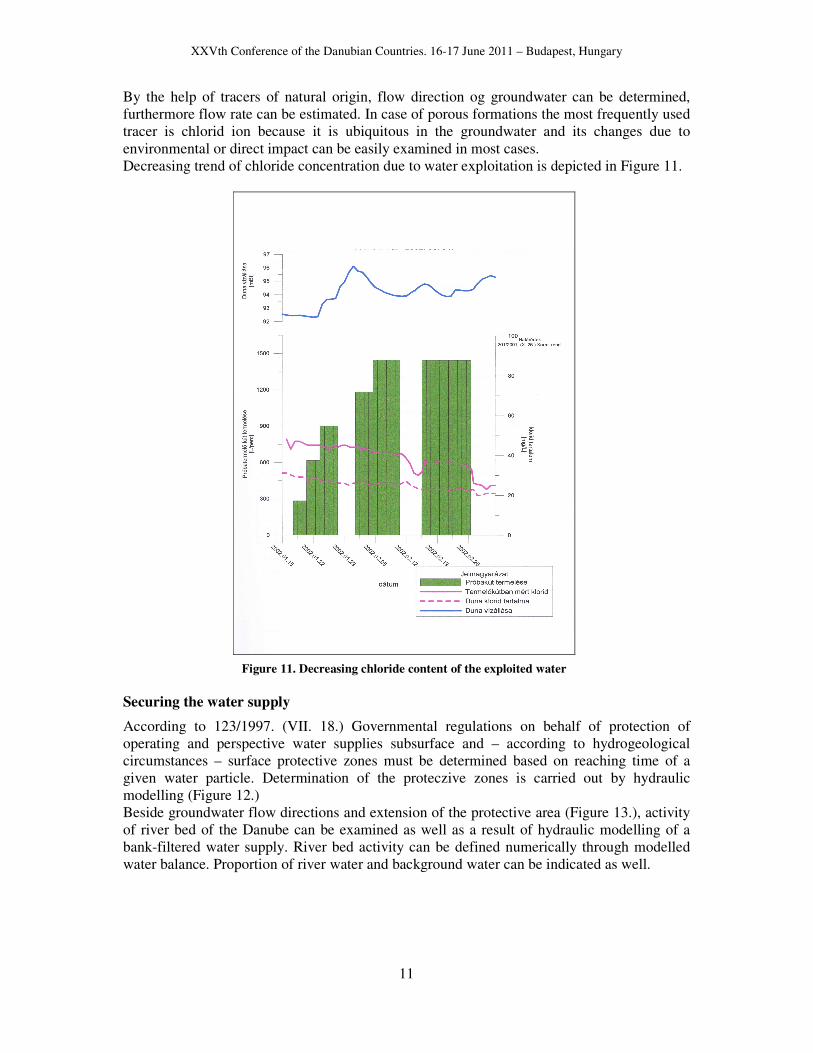
By the help of tracers of natural origin, flow direction og groundwater can be determined, furthermore flow rate can be estimated. In case of porous formations the most frequently used tracer is chlorid ion because it is ubiquitous in the groundwater and its changes due to environmental or direct impact can be easily examined in most cases. Decreasing trend of chloride concentration due to water exploitation is depicted in Figure 11.
Figure 11. Decreasing chloride content of the exploited water
Securing the water supply
According to 123/1997. (VII. 18.) Governmental regulations on behalf of protection of operating and perspective water supplies subsurface and – according to hydrogeological circumstances – surface protective zones must be determined based on reaching time of a given water particle. Determination of the proteczive zones is carried out by hydraulic modelling (Figure 12.) Beside groundwater flow directions and extension of the protective area (Figure 13.), activity of river bed of the Danube can be examined as well as a result of hydraulic modelling of a bank-filtered water supply. River bed activity can be defined numerically through modelled water balance. Proportion of river water and background water can be indicated as well.

XXVth Conference of the Danubian Countries. 16-17 June 2011 – Budapest, Hungary
12
Figure 12. Modelled depression of supply wells ,Margitsziget and Budaújlak water supplies ( at water level 97.18 m asl). One can see in the figure that depression of the two water
supplies overlap below the Danube
Figure 13. Flow paths in Budaújlak water supply, determined by reaching time of a
given water particle red: 20 days, green:180 days, blue: 5 years,
lilac: 50 years On behalf of quantitative and qualitative protection of water abstraction protective zones must be better preserved than the surrounding areas according to legal restrictions and interdicts concerning proceeding and planned human activities in the area. Regarding determination of protective zones of bank-filtered water supplies the biggest problem is that law (123/1997. (VII. 18.) Governmental regulations) considers only reaching times regardless of mixing of waters of different origin. Furthermore law does not provide on neither the protection of the river bed nor the method for determining protective zones. In case of a good aquifer, 90% of the exploited water may be of river origin in a bank-filtered water supply. Mixing of river water and contaminated background subsurface water generates that contamination dilutes in the river water as in the case of Budaújlak bank-filtered water supply has been operating for 120 years in Budapest. This water supply is surrounded by residental area and industrial establishments and supplies drinking water of excellent quality. Probability of contamination of the aquifer is much higher when the river itself is contaminated. According to effective law bank-filtered water supplies are not protected against neither permanent introduction of seawage water into Danube by industrial establishments above the water supply nor possible contaminations of havaria character. Establishment of a water quality monitoring system along the whole lenght of Danube is needed desperately. The method of numeric transport modelling is appropriate for simulating possible havaria events and passing and dilution of potential contamination in the river (Figure 14). The results of modelling are of great importance in realization of defensive measures recommended in the securing plan.

XXVth Conference of the Danubian Countries. 16-17 June 2011 – Budapest, Hungary
13
Figure 14. Numeric transport modelling of a momentary oil emission, Dunakeszi-Balpart water supply
(Modelled by Koncsos L.) The most extended operating bank-filtered water supplies are located along the Danube, between Danube bend and southern part of Csepel island. In the course of securing water supplies a big problem that the area of protective zones is one of the most exclusive residental area and holiday resort in Hungary. For this reason predictably expropriation and compensation expenses will be extremely high. Since the area grows dynamically an belongs to conurbation of Budapest, securing aspects are in contradiction with the interests of local authorities. Moreover bank-filtered water resources supply drinking water in regional extent thus supplied area and the area of protective zones differ that gives rise to aversion among inhabitants. Therefore PR activity on long term work processes and investigations (in connection with securing water supplies) in order to obtain the society’s confidence is of great importance. Participation of local authorities and inhabitants in PR activity is essential.
Summary Bank-filtered water resources have significant role in drinking water supply in Hungary. Therefore there is a wide range of tasks in connection with bank-filtered water supply protection. Great veriety of measurement approaches, that establish the base for determination of protective areas, are needed in order to get to know better bank-filtering processes. Method of the measurements considerably developed in the last five years, their application in the course of diagnostic investigations is essential.
References
Kontur Á. (1993): Parti sz�rés� vízbeszerzés a F�városi Vízm�veknél. Hidrológiai Közlöny, 1993/3. Rózsa A. (2000): Beszivárgási vizsgálatok a Szentendrei-Duna medrében. Hidrológiai Közlöny 2000/2. Völgyesi I. (1993): Mederkapcsolati hatásfok: a parti sz�rés� víztermelés fontos paramétere. – Hidrológiai Közlöny 1993/5.

XXVth Conference of the Danubian Countries. 16-17 June 2011 – Budapest, Hungary
14
SMARAGD-GSH Kft. (2001): Leányfalu Térségi Vízm� sérülékeny földtani környezet� vízbázisának diagnosztikai vizsgálata SMARAGD-GSH Kft. (2001): Pócsmegyer külterületen mederszonda, és a hozzá tartozó felszíni létesítmény kialakítása SMARAGD-GSH Kft. (2002): Halásztelek és Tököl külterületen egy-egy mederszonda kiépítése SMARAGD-GSH Kft. (2002): Mederszondás vizsgálatok lefolytatása az Ercsi Vízm� vízbázisának területén SMARAGD-GSH Kft. (2002):Váli-Víz távlati ivóvízbázis diagnosztikai vizsgálata SMARAGD-GSH Kft. (2002): Bogyiszló-Faddombori távlati ivóvízbázis diagnosztikai vizsgálata SMARAGD-GSH Kft. (2003)Nagymaros Térségi Vízm� vízbázisának diagnosztikai vizsgálata SMARAGD-GSH Kft. (2004)Budaújlaki Vízm�telep Vízbázisának diagnosztikai vizsgálata SMARAGD-GSH Kft. (2005): Margitszigeti ivóvízbázis biztonságba helyezési tervdokumentáció elkészítése SMARAGD-GSH Kft. (2009):Dunakeszi városi Vízm�, Duna Balpart-II Vízm�telep, Duna Balpart-I. Vízm�telep vízbázisának diagnosztikai vizsgálata