Embed Size (px)
Citation preview
WEST SEAHORSE PROJECT
GEOPHYSICAL & GEOTECHNICAL SURVEY ENVIRONMENT PLAN SUMMARY (VIC/P57)
(GIPPSLAND BASIN)Doc No : WSH‐CHP‐10‐RG‐LC‐002
Rev Issue Date
Reason For Issue Originator Reviewer Approver
0 23/07/2013 ISSUED TO NOPSEMA L. CHAPMAN M. POOLE T. STENSGAARD
West Seahorse Project Page 2 of 27
WSH‐CHP‐10‐RG‐LC‐0002 GEOTECHNICAL & GEOPHYSICAL SURVEY ENVIRONMENT PLAN SUMMARY (Vic/P57)
Rev 0
This is an electronically generated document which has been reviewed and approved in accordance with Hibiscus Petroleum Management System. An audit trail of review and approval is available within the electronic document management system. The Electronic Document Management System Latest Revision of this document is the CONTROLLED COPY at all times. When printed it is considered a FOR INFORMATION ONLY copy, and it is the holder’s responsibility that he / she holds the latest valid version. , Hibiscus Petroleum Or A Subsidiary Thereof, Copyright 2012 And Design Right Reserved. Copying, Distribution And/Or Disclosure Of The
Confidential Information Contained Herein Is Prohibited Without Written Permission Of The Proprietor.
TABLE OF CONTENTS
1.0 INTRODUCTION ................................................................................................................................5
2.0 ACTIVITY LOCATION ..........................................................................................................................6
3.0 ACTIVITY DESCRIPTION .....................................................................................................................8 3.1 SURVEY SCOPE ............................................................................................................................................... 8 3.2 SURVEY VESSELS .......................................................................................................................................... 10
4.0 DESCRIPTION OF THE RECEIVING ENVIRONMENT ........................................................................... 11 4.1 GENERAL ENVIRONMENTAL SETTING ......................................................................................................... 11 4.2 PHYSICAL ENVIRONMENT ............................................................................................................................ 11 4.3 MARINE SPECIES .......................................................................................................................................... 12 4.4 SOCIAL ENVIRONMENT................................................................................................................................ 13
4.4.1 COMMERCIAL SHIPPING .................................................................................................................. 13 4.4.2 FISHERIES ......................................................................................................................................... 14 4.4.3 COMMONWEALTH/STATE HERITAGE .............................................................................................. 15 4.4.4 OIL & GAS DEVELOPMENT ............................................................................................................... 15
5.0 ASSESSMENT OF ENVIRONMENTAL HAZARDS AND CONTROLS ....................................................... 16
6.0 SUMMARY OF MANAGEMENT APPROACH...................................................................................... 24
7.0 CONSULTATION PROCESS ............................................................................................................... 25
8.0 CONTACT DETAILS .......................................................................................................................... 26
9.0 REFERENCES ................................................................................................................................... 27
West Seahorse Project Page 3 of 27
WSH‐CHP‐10‐RG‐LC‐0002 GEOTECHNICAL & GEOPHYSICAL SURVEY ENVIRONMENT PLAN SUMMARY (Vic/P57)
Rev 0
ABBREVIATIONS
µPa Micro‐pascal
AFMA Australian Fisheries Management Authority
AHO Australian Hydrographic Office
AIS Automatic Identification System
ALARP As Low as Reasonably Practicable
AMSA Australian Maritime Safety Authority
ASBTIA Australian Southern Bluefin Tuna Industry Association
CAMBA China/Australia Migratory Birds Agreement
CFA Commonwealth Fisheries Association
CPT Cone Penetration Tests
dB Decibels
DBCDE Department of Broadband, Communications and the Digital Economy
DEPI Department of Environment and Primary Industry
DEWHA Department of Environment, Water, Heritage and the Arts
DSDBI Department of State Development, Business and Innovation
EPBC Environment Protection Biodiversity Conservation
ESTF Eastern Skipjack Tuna Fishery
ETBF Eastern Tuna and Billfish Fishery
FSO Floating Storage and Offloading Vessel
GHaT Gillnet, Hook and Trap Sectors
Ha Hectares
Hz Hertz
IMO International Maritime Organisation
IMS Invasive Marine Species
JAMBA Japan/Australia Migratory Birds Agreement
JVP’s Joint Venture Partners
kHz Kilohertz
km Kilometre
LEFCOL Lakes Entrance Fisherman’s Cooperative Pty Ltd
m Metres
MARPOL Marine pollution protocol
MBES Multibeam Echo Sounders
MDO Marine Diesel Oil
MGO Marine Gas Oil
MOPU Mobile Offshore Petroleum Unit
MSDS Material Safety Data Sheet
NNTT National Native Title Tribunal
NOO National Oceans Office
NOPSEMA National Offshore Petroleum Safety and Environmental Management Authority
NOPTA National Offshore Petroleum Titles Administrator
NOx Nitrous oxides
West Seahorse Project Page 4 of 27
WSH‐CHP‐10‐RG‐LC‐0002 GEOTECHNICAL & GEOPHYSICAL SURVEY ENVIRONMENT PLAN SUMMARY (Vic/P57)
Rev 0
OCNS Offshore Chemical Notification Scheme
ODME Oil Detection Monitoring Equipment
OIW Oil in Water
OPGGSA Offshore Petroleum and Greenhouse Gas Storage Act 2006
OPGGSER Offshore Petroleum and Greenhouse Gas Storage (Environment) regulations 2009
OSCP Oil Spill Contingency Plan
PLONOR Poses Little or No Risk
POB Persons on Board
PROD Portable remotely operated drill
R Regulation
RAMSAR RAMSAR Convention on Wetlands
RCC Rescue Coordination Centre
ROKAMBA Republic of Korea/ Australia Migratory Birds Agreement
SBTF Southern Bluefin Tuna Fishery
SEWPC Department of Environment, Water, Population and Communities
SEL Sound Exposure Level
SESSF Southern and Eastern Scalefish and Shark Fishery
SETFIA South East Trawl Fishing Industry Association
SFD Seafloor Drilling
SIV Seafood Industry Victoria
SOLAS Safety of Life at Sea Convention
SOPEP Shipboard Oil Pollution Emergency Plan
SOx Sulphur oxides
SPF Small Pelagic Fishery
SSE South‐south east
STCW95 International Convention on Standards of Training, Certification and Watch‐keeping
SW South West
Tcf Trillion cubic feet
TTS Temporary Threshold Shift
VIC Victoria
W West
WA Western Australia
WNW West‐North‐West
WSH West Seahorse
WSW West‐South‐West
West Seahorse Project Page 5 of 27
WSH‐CHP‐10‐RG‐LC‐0002 GEOTECHNICAL & GEOPHYSICAL SURVEY ENVIRONMENT PLAN SUMMARY (Vic/P57)
Rev 0
1.0 INTRODUCTION
Carnarvon Hibiscus (‘Hibiscus’), on behalf of the West Seahorse (WSH) Joint Partners (JVPs), Hibiscus and 3D Oil Limited, is proposing to undertake a Geotechnical and Geophysical Survey in the Commonwealth waters (Gippsland Basin) to support site selection for the WSH Development infrastructure. The WSH Field lies in Petroleum Exploration Permit Vic/P57.
The purpose of the survey is to:
Obtain information on the seabed conditions at the WSH location for the proposed development infrastructure (Mobile Offshore Production Unit [MOPU], export crude flowline and Floating Storage and Offloading [FSO] Vessel); and
Geotechnical information for the MOPU foundations, possible export flowline burial, and anchoring of CALM BUOY.
Hibiscus, as nominated Environmental Operator for this petroleum activity within Vic/P57, has prepared an Environment Plan in accordance with the requirements of the Offshore Petroleum and Greenhouse Gas Storage (Environment) Regulations 2009 which has been reviewed and accepted by the National Offshore Petroleum Safety and Environmental Management Authority (NOPSEMA).
This Environment Plan Summary document has been prepared to comply with the requirements of Regulation 11(7) and (8) of the referenced Offshore Petroleum and Greenhouse Gas Storage (Environment) Regulations 2009.
West Seahorse Project Page 6 of 27
WSH‐CHP‐10‐RG‐LC‐0002 GEOTECHNICAL & GEOPHYSICAL SURVEY ENVIRONMENT PLAN SUMMARY (Vic/P57)
Rev 0
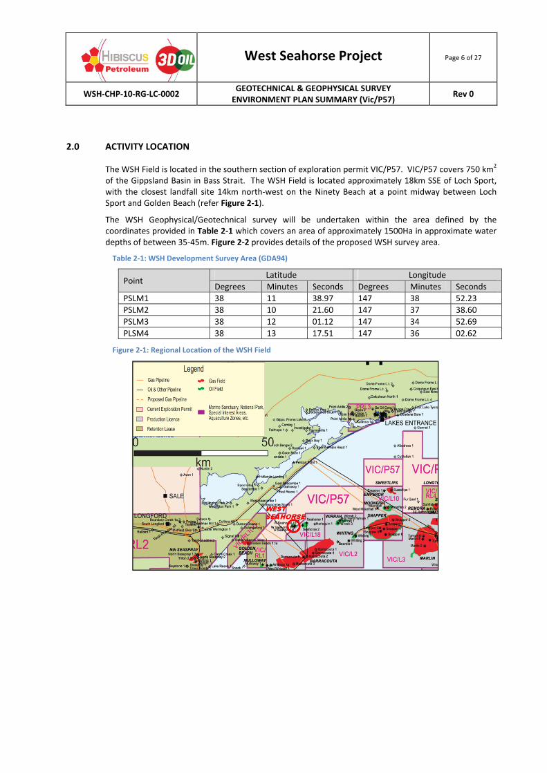
2.0 ACTIVITY LOCATION
The WSH Field is located in the southern section of exploration permit VIC/P57. VIC/P57 covers 750 km2 of the Gippsland Basin in Bass Strait. The WSH Field is located approximately 18km SSE of Loch Sport, with the closest landfall site 14km north‐west on the Ninety Beach at a point midway between Loch Sport and Golden Beach (refer Figure 2‐1).
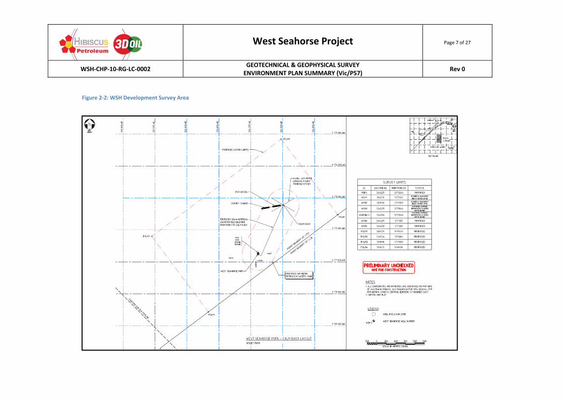
The WSH Geophysical/Geotechnical survey will be undertaken within the area defined by the coordinates provided in Table 2‐1 which covers an area of approximately 1500Ha in approximate water depths of between 35‐45m. Figure 2‐2 provides details of the proposed WSH survey area.
Table 2‐1: WSH Development Survey Area (GDA94)
Point Latitude Longitude
Degrees Minutes Seconds Degrees Minutes Seconds
PSLM1 38 11 38.97 147 38 52.23
PSLM2 38 10 21.60 147 37 38.60
PSLM3 38 12 01.12 147 34 52.69
PLSM4 38 13 17.51 147 36 02.62
Figure 2‐1: Regional Location of the WSH Field
West Seahorse Project Page 7 of 27
WSH‐CHP‐10‐RG‐LC‐0002 GEOTECHNICAL & GEOPHYSICAL SURVEY ENVIRONMENT PLAN SUMMARY (Vic/P57)
Rev 0
Figure 2‐2: WSH Development Survey Area
West Seahorse Project Page 8 of 27
WSH‐CHP‐10‐RG‐LC‐0002 GEOTECHNICAL & GEOPHYSICAL SURVEY ENVIRONMENT PLAN SUMMARY (Vic/P57)
Rev 0
3.0 ACTIVITY DESCRIPTION
3.1 SURVEY SCOPE
The survey scope consists of the following two components:
Geophysical Survey which may consist of: o Bathymetry assessment across the alignment measured using a Multibeam Echo
Sounder (MBES). This equipment emits sound levels of 220dB re 1µPa at a frequency of approximately 200kHz (high frequency);
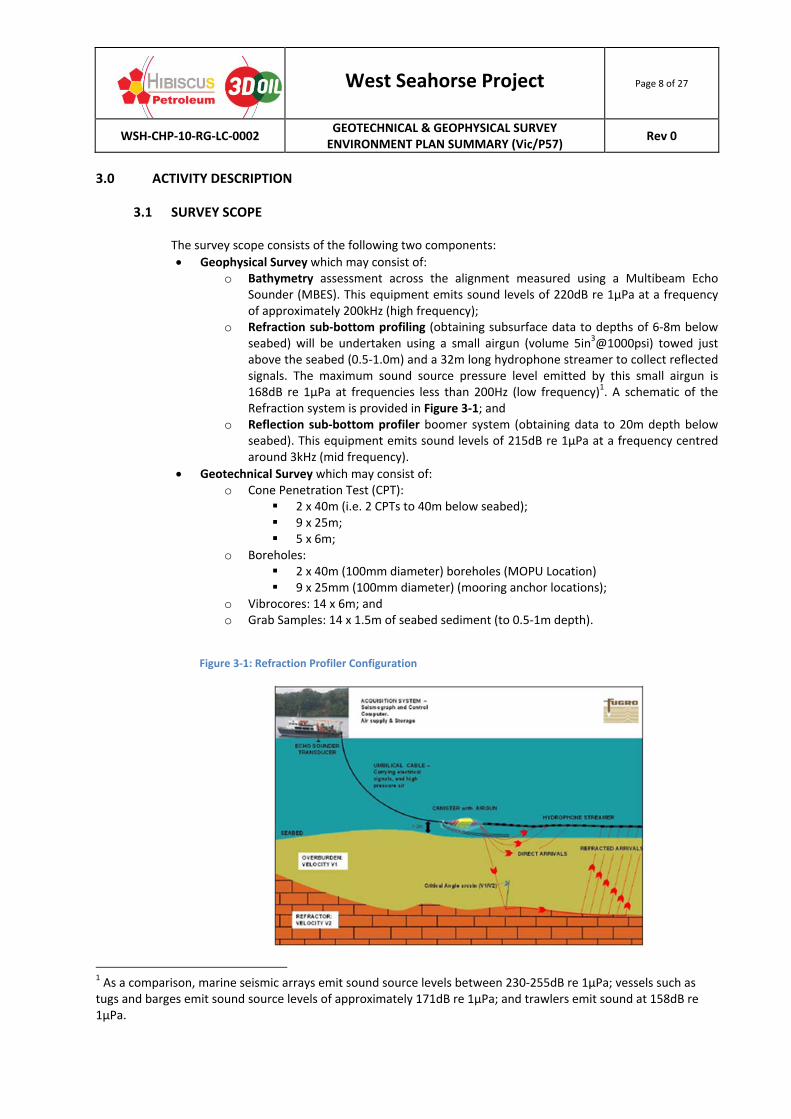
o Refraction sub‐bottom profiling (obtaining subsurface data to depths of 6‐8m below seabed) will be undertaken using a small airgun (volume 5in3@1000psi) towed just above the seabed (0.5‐1.0m) and a 32m long hydrophone streamer to collect reflected signals. The maximum sound source pressure level emitted by this small airgun is 168dB re 1µPa at frequencies less than 200Hz (low frequency)1. A schematic of the Refraction system is provided in Figure 3‐1; and
o Reflection sub‐bottom profiler boomer system (obtaining data to 20m depth below seabed). This equipment emits sound levels of 215dB re 1µPa at a frequency centred around 3kHz (mid frequency).
Geotechnical Survey which may consist of: o Cone Penetration Test (CPT):
2 x 40m (i.e. 2 CPTs to 40m below seabed); 9 x 25m; 5 x 6m;
o Boreholes: 2 x 40m (100mm diameter) boreholes (MOPU Location) 9 x 25mm (100mm diameter) (mooring anchor locations);
o Vibrocores: 14 x 6m; and o Grab Samples: 14 x 1.5m of seabed sediment (to 0.5‐1m depth).
Figure 3‐1: Refraction Profiler Configuration
1 As a comparison, marine seismic arrays emit sound source levels between 230‐255dB re 1µPa; vessels such as tugs and barges emit sound source levels of approximately 171dB re 1µPa; and trawlers emit sound at 158dB re 1µPa.
West Seahorse Project Page 9 of 27
WSH‐CHP‐10‐RG‐LC‐0002 GEOTECHNICAL & GEOPHYSICAL SURVEY ENVIRONMENT PLAN SUMMARY (Vic/P57)
Rev 0
For the geophysical survey activities the MBES bathymetry data will be collected concurrently with the refraction (airgun) survey lines and additional bathymetry infill lines will be obtained to achieve 100% bathymetry coverage. The refraction and reflection sub‐bottom profiling surveys cannot be undertaken simultaneously, therefore following a preliminary onboard assessment of the refraction data, the reflection (Boomer) survey will be carried out along the same refraction lines to allow for overlap of data.
Equipment which may be utilized for the geotechnical survey activities include:
Seabed CPT Unit: This testing method pushes an instrumented cone into the sediment using a seabed reaction frame and records the resistance of the head of the cone. The footprint of the equipment when resting on the seabed is approximately 2m x 2m. The
diameter of the CPT rod pushed into the seabed is ~44 mm and is expected to generate a surface diameter of 66mm (the hole will be self‐closing after the CPT rod is withdrawn);
Vibrocore Equipment: Vibrocore equipment is an electrically driven vibrating corer capable of obtaining 76mm diameter cores. Corers consist of a demountable tower, and watertight aluminium/steel vibrating drive unit containing two 3‐phase electric motors. The corer stands freely on the seabed, braced by three 2.5m long retractable legs with attachments to winch cable and an independent electrical cable;
Seabed Drilling Systems: o Sea Floor Drilling (SFD): The SFD package utilizes wire‐line coring to obtain
subsurface soil samples from an aluminium core barrel installed by a rotary drill bit. The footprint of the equipment is 3.8m (W) x 5.4m (L) x 6.6m (H). The equipment produces a core diameter of up to 83mm.
o ROVDrill: A self‐contained drilling and geotechnical testing system utilizing a polymer injection mud system with real‐time monitoring of the operation (cameras and sensors). The footprint of the equipment when resting on the seabed is 2.3m (W) x 5.5m (L) x 5.4m (H). The equipment produces a core diameter of up to 85mm.
o Portable Remotely Operated Drill (PROD) System: This fully self‐contained PROD system utilizes a rotary system to undertake geotechnical surveys and has a seabed footprint of 2m (W) x 2m(L)x 3m(H). This equipment produces a core diameter of 44mm.
All units are controlled manually from surface vessels utilizing closed‐system hydraulics. All seabed drilling units may utilize additives to the seawater drilling fluid to optimize coring activities. These chemicals include polymer muds such as Pure‐Bore Liquid or equivalent.
The Geotechnical and Geophysical survey may be undertaken as two separate activities (i.e. two vessel mobilizations) with the geophysical survey informing the location of subsequent geotechnical activities within the survey area. Scopes for these survey(s) are found in Table 3‐1. Table 3‐1: Possible Geophysical/Geotechnical Program Scope
Survey Scope/DetailsSurvey 1: Geophysical/ Geotechnical Survey Duration:
~10‐12days
Scope:
Bathymetry Assessment (MBES)
Refraction Sub‐bottom Profiling (Airgun)
Reflection Sub‐bottom Profiling (Boomer)
10 x 5m Cone Penetration Tests
14 x 1.5m grab samples of seabed sediment (to 0.5m‐1m depth).
West Seahorse Project Page 10 of 27
WSH‐CHP‐10‐RG‐LC‐0002 GEOTECHNICAL & GEOPHYSICAL SURVEY ENVIRONMENT PLAN SUMMARY (Vic/P57)
Rev 0
Survey Scope/DetailsVessel Requirements: Small local marine survey vessel with crane capability to launch CPT unit with the following typical specifications:
Gross Tonnage ~300tonnes;
Length ~35m;
Breadth ~11m;
Draft~2m;
POB~32 persons;
Max Fuel Tank size~25m3 (Marine Diesel Oil)
Survey 2: Geotechnical Survey Duration:
~25days
Scope:
2 x 40m (100mm diameter) borehole (MOPU location);
9 x 25m (100mm diameter) boreholes (mooring anchor locations);
CPTs: 2 x 40m; 9 x 25; 5 x 6m;
14 x 6m vibrocores;
14 x 1.5m grab samples of seabed sediment (to 0.5m‐1m depth).
Vessel Requirements: Larger Marine Survey vessel with the following typical specifications:
Gross Tonnage ~2440‐4500tonnes;
Length ~67‐90m;
Breadth ~16‐20m;
Draft~6m;
POB~40‐60 persons;
Max Fuel Tank size~80m3 (Marine Diesel Oil)
The Geophysical and Geophysical Surveys will operate on a 24hr/7day basis and will be undertaken during the period August 1st and December 31st 2013.
Timing of the commencement of the geophysical and geotechnical fieldwork is dependent on sea states suitable for data acquisition, the availability of a survey vessel and the granting of approvals from appropriate government authorities.
3.2 SURVEY VESSELS
The survey vessel for the proposed WSH geophysical and geotechnical survey has not yet been selected. Dependent on the geotechnical scope of work2, it is possible that the selected geophysical survey vessel may undertake the complete geophysical/geotechnical work‐scope. In this instance a smaller geophysical survey vessel will mobilize to the WSH location from Lakes Entrance. If a larger geotechnical vessel is required to undertake boring works, the vessel will mobilize from Australian waters, however from ports located outside the Gippsland Basin.
All vessels selected for the WSH survey activities will have the necessary Class Certification/ Registration and will be compliant with all the requirement of the MARPOL/SOLAS conventions including a Shipboard Oil Pollution Emergency Plan (SOPEP) (or equivalent appropriate to size and class) in accordance with MARPOL 73/78 Annex I (Regulation 37) and the Protection of the Seas (Prevention of Pollution from Ships) Act 1983.
During the survey, no ‘at sea’ refueling will take place. All crew changes and resupply of vessels will take place at port.
The supply port for the smaller geophysical survey is expected to be Lake Entrance. The supply port for a larger geotechnical survey vessel, if required, is expected to be Port of Geelong.
2 Seabed Drilling System deployment (for bores) will require a larger multi‐purpose dynamically‐positioned (DP) geotechnical survey vessel for the activity.
West Seahorse Project Page 11 of 27
WSH‐CHP‐10‐RG‐LC‐0002 GEOTECHNICAL & GEOPHYSICAL SURVEY ENVIRONMENT PLAN SUMMARY (Vic/P57)
Rev 0
4.0 DESCRIPTION OF THE RECEIVING ENVIRONMENT
4.1 GENERAL ENVIRONMENTAL SETTING
The WSH survey area is located on the Twofold Shelf Bioregion of the South East Marine Region (NOO, 2002). The continental shelf is relatively narrow in the northern section, becoming much broader and shallower in the southern area of the Gippsland Basin. The Twofold Shelf area is strongly influenced by a number of different currents that run through and near by the shelf, bringing both warm and cool currents. Nutrients from cooler upwellings supply rich biota that thrives in the warmer, shallower shelf region (NOO, 2002). Fauna is characterized by assemblages of reef fish, echinoderms, gastropods and bivalves (NOO, 2002).
The coastline consists of long sandy beaches broken by rocky headlands and numerous coastal lagoons. Estuary systems occur along the coastline within the region, with the larger estuaries located at Lakes Entrance (Gippsland Lakes); Sydenham Inlet and Mallacoota Inlet (NOO, 2002). Most of these estuary systems are normally closed to the marine environment.
The nearest Victorian State Marine Reserves to the survey area are:
Ninety Mile Beach Marine National Park is located approximately 37km southwest;
Nooramunga Marine and Coastal Park (Vic) is located approximately 77km southwest;
Beware Reef Marine Sanctuary located approximately 105km ENE;
Wilsons Promontory Marine Park is located approximately 130km SW; and
Point Hicks State Marine National Park (VIC) located approximately 150km ENE.
The nearest Commonwealth Marine Reserves to the survey area are:
East Gippsland Commonwealth Marine Reserve located approximately 200km ESE; and
Beagle Commonwealth Marine Reserve located approximately 110km SSW.
The nearest Coastal Park to the survey area is the Gippsland Lakes Coastal Park, located approximately 14km west, and is a narrow coastal reserve covering 17000Ha along the Ninety Mile Beach from Seaspray to Lakes Entrance. The park consists of lakes and wetlands and is jointly managed by Parks Victoria and the Gunaikurnai as traditional owners of the land. The area is popular for camping along Shoreline Drive, surf fishing and swimming and is rich in wildlife including Eastern Grey Kangaroos, Black Wallabies and the Common brush‐tail and Ring‐tailed possums (Parks Victoria, 2013). This coastal park forms a dune barrier which protects the Gippsland Lakes RAMSAR site from sea‐based impacts. This RAMSAR area contains 540 flora species and 300 species of indigenous fauna and migratory bird species listed under the Japan‐Australia Migratory Bird Agreement (JAMBA) and China‐Australia Migratory Bird Agreement (CAMBA) (Parks Victoria, 2003).
4.2 PHYSICAL ENVIRONMENT
The climate of the Twofold Shelf bioregion is moist, cool temperate with warm summers and a tendency towards winter‐spring rainfall (NOO, 2002).
The Permit, Vic/P57, is protected from south‐westerly swells by Tasmania but is strongly influenced by south‐easterly and easterly swell heights of 1‐1.5m with maximum heights varying between 1.9 and 2.7m (LCC, 1993; cited in Barton et al, 2012). Stalled low pressure systems in the Tasman Sea during summer can generate higher wave energy at this time (NOO, 2002).
Tides within the South East Marine Region show seasonal variation with spring tides of approximately 0.9m and neap tides of 0.6m (Parks Victoria, 2013). Strong semi‐diurnal tidal currents (2‐2.5knots) run parallel to the coast and are characteristic of this area (Barton et al, 2012).
West Seahorse Project Page 12 of 27
WSH‐CHP‐10‐RG‐LC‐0002 GEOTECHNICAL & GEOPHYSICAL SURVEY ENVIRONMENT PLAN SUMMARY (Vic/P57)
Rev 0
The seabed at the WSH location is relatively flat and featureless on a sandy seabed with localized depressions (not considered pock‐marks) in water depths of approximately 38‐40m. No debris is evident at the current WSH‐3 location [part of the survey area] (Fugro, 2007).
4.3 MARINE SPECIES
The Southeast Marine Region displays a large diversity of plant and animal species. In addition to high diversity, the region has large numbers of endemic species including 600 species of fish, of which 85% are thought to be endemic and 11% are common only to waters of neighbouring New Zealand.
Mega fauna species such as whales, shark and turtles migrate through these waters. A search of the EPBC Act Protected Matters Database (SEWPC, 2013a) identified the following species as potentially having habitat within the survey area (refer Table 3‐1):
Twelve (12) species of cetacean are listed. Three (3) species have a threatened status and eight (8) species have a migratory status. It is possible that cetacean species may be encountered in the survey area on a transitory basis only. The survey area is not considered biologically significant (i.e. breeding, feeding or resting) for these species;
Three (3) reptile species have a threatened and migratory status. Encounter with marine turtles is expected to be low as the WSH survey area is considered outside the usual range or does not contain suitable habitat (i.e. deep water) for a number of the listed turtle species;
Three (3) species of shark are listed. Two (2) species have a threatened status and all species have a migratory status. Species are expected to have a transitory presence in the survey area and encounter is expected to be low;
Eighteen (18) bird species are listed as threatened and sixteen (16) listed as migratory marine bird species. These birds may overfly and forage in the WSH survey area, however the survey area is not biologically significant for these marine bird species;
Twenty‐seven (27) species of fish are listed including one which is vulnerable, nineteen (19) species of pipefish, three (3) species of pipe‐horse, one (1) species of sea‐dragon and four (4) species of sea‐horse; and
Two additional mammal species also have habitat within Bass Strait waters, the New Zealand Fur Seal (Arctocephalus forster) and Australian Fur Seal (Arctocephalus pusillus doriferus) (Shaughnessy, 1999). These species do not have an EPBC protection status but are listed under that legislation and may be encountered foraging within the survey area. The
closest breeding site is at Wilson’s promontory (~130km SW) and the Skerries (~175km NE).
Table 4‐1: EPBC Listed Threatened/Migratory Species for the WSH Survey Corridor (SEWPC, 2013a)
Status: Likelihood of Occurrence:
E: Endangered LO: Species/species habitat likely to occur in area
V: Vulnerable MO: Species/species habitat may occur within area
M: Migratory KO: Species/species habitat known to occur within area
L: Listed BLO: Breeding Likely to Occur
FLO: Foraging Likely to Occur
Species Type Scientific Name Common Name EPBC Status Type of Presence
Marine Birds
Apus pacificus Fork‐tailed Swift M LO
Botaurus poiciloptilus Australiasian Bittern E KO
Diomedea epomophora epomophora
Southern Royal Albatross V, M MO
Diomedea epomophora sanfordi Northern Royal Albatross E, M MO
Diomedea exulans antipodensis Antipodean Albatross V, M FLO
Diomedea exulans exulans Tristan Albatross E, M MO
West Seahorse Project Page 13 of 27
WSH‐CHP‐10‐RG‐LC‐0002 GEOTECHNICAL & GEOPHYSICAL SURVEY ENVIRONMENT PLAN SUMMARY (Vic/P57)
Rev 0
Status: Likelihood of Occurrence:
E: Endangered LO: Species/species habitat likely to occur in area
V: Vulnerable MO: Species/species habitat may occur within area
M: Migratory KO: Species/species habitat known to occur within area
L: Listed BLO: Breeding Likely to Occur
FLO: Foraging Likely to Occur
Species Type Scientific Name Common Name EPBC Status Type of Presence
Diomedea exulans gibsoni Gibson’s Albatross V, M FLO
Diomedea exulans (sensu lato) Wandering Albatross V, M FLO
Fregetta grallaria grallaria White‐bellied Storm Petrel V LO
Halobaena caerulea Blue Petrel V MO
Macronectes giganteus Southern Giant‐Petrel E, M MO
Macronectes halli Northern Giant‐Petrel V, M MO
Puffinus carneipes Flesh‐footed Shearwater M FLO
Sternula nereis nereis Fairy Tern V KO
Thalassarche bulleri Buller’s Albatross V,M MO
Thalassarche cauta cauta Tasmanian Shy Albatross V, M MO
Thalassarche chrysostoma Grey‐headed Albatross E, M MO
Thalassarche melanophris Black‐browed Albatross V, M MO
Thalassarche cauta salvini Salvin’s Albatross V, M MO
Thalassarche impravida Campbell Albatross V,M MO
Marine Mammals Balaenoptera acutorostrata Minke Whale L MO
Balaenoptera edeni Bryde’s Whale M MO
Balaenoptera musculus Blue Whale E, M LO
Caperea marginata Pygmy Right Whale M MO
Delphinus delphis Common Dolphin L MO
Eubalaena australis Southern Right Whale E, M KO
Grampus griseus Risso’s Dolphin L MO
Lagrnorhynchus obscurus Dusky Dolphin M MO
Megaptera novaeangliae Humpback Whale V, M LO
Orcinus orca Killer Whale M MO
Tursiops aduncus Spotted Bottlenose Dolphin L LO
Tursiops truncatus Bottlenose Dolphin L MO
Arctocephalus forsteri New Zealand Fur Seal L MO
Arctocephalus pusillus Australian Fur Seal L MO
Sharks/Fish Carcharodon carcharias Great White Shark V, M MO
Lamna nasus Porbeagle, Mackerel Shark M LO
Irurus oxyrinchus Shortfin Mako, Mako Shark M LO
Rhincodon typus Whale Shark V, M MO
Prototroctes maraena Australian Grayling V LO
Reptiles Caretta caretta Loggerhead Turtle E, M LO
Chelonia mydas Green Turtle V,M KO
Dermochelys coriacea Leatherback Turtle E, M LO
4.4 SOCIAL ENVIRONMENT
4.4.1 Commercial Shipping
Bass Strait is one of Australia’s busiest commercial shipping routes in Australia with more than 3000 vessels making the east‐west passage through Bass Strait each year (NOO, 2002). A vessel traffic separation scheme has been instituted between the Victorian/NSW border and Wilsons
West Seahorse Project Page 14 of 27
WSH‐CHP‐10‐RG‐LC‐0002 GEOTECHNICAL & GEOPHYSICAL SURVEY ENVIRONMENT PLAN SUMMARY (Vic/P57)
Rev 0
Promontory to enhance maritime safety in the area separating shipping into discrete, one direction lanes. Additionally, an “Area to be Avoided” has be designated by the International Maritime Organisation (IMO) to protect the Esso‐BHP Bass Strait Oil and Gas Facilities. As such all ships over 200 gross tonnage are restricted to the shipping channels to the east and south of this area.
The proposed WSH survey area is located within the Bass Strait ‘Area to be Avoided’. AMSA (2013) has advised that vessel encounter will be limited to commercial fishing and recreational vessels.
4.4.2 Fisheries
Commonwealth fisheries, managed by the Australian Fisheries Management Authority (AFMA), and Victorian state‐managed fishing areas, managed by the Victorian Department of Environment and Primary Industries (DEPI) are located in the WSH survey area. Fisheries form a significant source of employment and income to the region.
AFMA (2012) have advised that the WSH survey area lies in the following Commonwealth‐managed fishing areas:
Southern and Eastern Scalefish and Shark Fishery (SESSF) (includes the Commonwealth Trawl Sector (CTS), Gillnet, Hook and Trap Sectors (GHaT)) (consultation has identified that Danish seine operators, predominantly located at Lakes Entrance, and gillnet fishermen may be present in the area at the time of the WSH survey);
Small Pelagics Fishery (SPF) (consultation has identified that it is unlikely that members of the SPF will be present in the WSH survey area during the survey);
Southern Bluefin Tuna Fishery (SBTF) (consultation has identified that this fishery does not operate in the WSH survey area);
Eastern Tuna and Billfish Fishery (ETBF) (consultation has identified that members of this fishery will not be present in the WSH survey area);
Skipjack Tuna Fishery (consultation has identified that this fishery does not operate in the WSH survey area); and
Southern Squid Jig Fishery (consultation has identified that it is unlikely that members of this fishery will have a presence in the area at the time of the WSH Survey).
DEPI (2013) has advised that the following state‐managed fisheries which are permitted to operate within the WSH Survey area include the following:
Ocean Access Fishery (this fishery may be active within the area during the survey);
Ocean Purse Seine Fishery (consultation identified that only one Licence is active in Victorian waters);
Rock Lobster Fishery (consultation has identified that given the sandy substrates within the WSH survey area, rock lobster fishermen do not actively fish the area);
Giant Crab Fishery (consultation has identified that crab fishermen do not actively fish the area);
Inshore (Ocean) Trawl Fishery (this fishery has not been recorded as having a fishing presence in the WSH survey area); and
Ocean Scallop Fishery (this fishery opened on April 1 this year (12 month season) and may be present in the WSH survey area during survey activities in 2013).
DEPI (2013) also advises that in the past ten years only two fisheries have been active within the WSH survey area – the Ocean Access Fishery and the Ocean Scallop Fishery.
West Seahorse Project Page 15 of 27
WSH‐CHP‐10‐RG‐LC‐0002 GEOTECHNICAL & GEOPHYSICAL SURVEY ENVIRONMENT PLAN SUMMARY (Vic/P57)
Rev 0
4.4.3 Commonwealth/State Heritage
There are no listed Commonwealth Heritage Places, National Heritage Places or places on the Register of National Estate within, or in the immediate vicinity of the proposed WSH survey area. The closest Commonwealth Heritage Place is the Gabo Island Lighthouse located 215km ENE of the survey area (SEWPC, 2013b).
Review of the National Shipwreck Database showed that no Historic Shipwrecks lay within the WSH survey area (SEWPC, 2013c). The closest shipwreck is the Julius (16km NE of the survey location). Other wrecks include an unknown wreck 45km south of the survey area, Trinculo (1879) wrecked on Ninety Mile Beach (25km from survey location) and the Norfolk, also wrecked on Ninety Mile Beach approximately 20km from the survey location (SEWPC, 2013c).
4.4.4 Oil & Gas Development
The Gippsland Basin has been producing hydrocarbons since 1969 (a total of 4 billion barrels of liquids and 9.8Tcf of gas to the end of June 1998). Currently the Gippsland Basin has (DPI, 2011):
Seventeen (17) developed offshore oil and gas fields;
Twenty‐four (24) offshore production facilities (platforms, mono‐towers & subsea completions); and
Over 600km of pipeline network.
Onshore oil and gas processing facilities are located at both Longford and Orbost. Most of this infrastructure is operated by Esso Australia Resources Pty Ltd.
The WSH survey is located approximately 11.5km WNW of Esso‐BHP’s Barracouta platform and 5km west of the Seahorse subsea wellhead. The survey location is 38km east of the Longford Onshore Processing Facility.
The WSH survey area is located entirely within Petroleum Exploration Permit Vic/P57.
West Seahorse Project Page 16 of 27
WSH‐CHP‐10‐RG‐LC‐0002 GEOTECHNICAL & GEOPHYSICAL SURVEY ENVIRONMENT PLAN SUMMARY (Vic/P57)
Rev 0
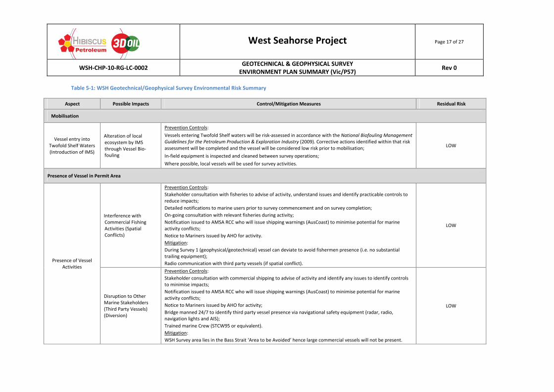
5.0 ASSESSMENT OF ENVIRONMENTAL HAZARDS AND CONTROLS
In accordance with the Offshore Petroleum and Greenhouse Gas Storage (Environment) Regulations 2009 R14(3) and R14(3A), an environmental hazard identification and risk assessment has been undertaken to evaluate the potential sources of environmental impact associated with the WSH survey activities. This included an assessment of risks arising from operational activities, unplanned events (non‐routine/accident) and incident response activities and can be grouped into the following broad categories:
Mobilization of Survey Vessel to Survey area: o Introduction of Invasive Marine Species (IMS) from biofouling;
Physical presence of the Survey Vessel3: o Disruption to commercial fishing activities and third party vessel movement;
Sound impacts to the marine environment4: o Discharge of acoustic sound sources in the survey area; o Sound from operation of vessels;
Seabed Disturbance Activities; o Cone Penetration Tests (CPTs)/boring; o Drilling fluid releases;
General vessel operations: o Routine waste discharges from the survey vessel:
Oily water discharge; Sewage discharges; Food‐scrap discharges; and
o Air Emissions (combustion sources);
Non‐Routine events; o Accidental hydrocarbon spill due to collision with another vessel or vessel
integrity incident; o Chemical/oil spill through deck drain system; o Solid non‐biodegradable/hazardous waste overboard incident; o Towed Equipment loss in the marine environment; o Hydraulic line liquid release from subsea equipment; and o Collision with a cetacean.
Implemented control measures identified in Table 5‐1 ensure that the environmental risk associated with these hazards is as low as reasonably practicable (ALARP). Control measures are taken into consideration in calculating the residual risk associated with the activity impact reflected in Table 5‐1.
3 Lighting on‐board vessel will be limited to navigation lighting and workplace safety requirements. The WSH location is not in
proximity to sensitive location such as turtle or seabird nesting beaches (i.e. ~14km from shore). This hazard, and its possible impact, is considered ALARP on this basis. 4 No helicopter operations will occur for these survey activities.
West Seahorse Project Page 17 of 27
WSH‐CHP‐10‐RG‐LC‐0002 GEOTECHNICAL & GEOPHYSICAL SURVEY ENVIRONMENT PLAN SUMMARY (Vic/P57)
Rev 0
Table 5‐1: WSH Geotechnical/Geophysical Survey Environmental Risk Summary
Aspect Possible Impacts Control/Mitigation Measures Residual Risk
Mobilisation
Vessel entry into Twofold Shelf Waters (Introduction of IMS)
Alteration of local ecosystem by IMS through Vessel Bio‐fouling
Prevention Controls:
Vessels entering Twofold Shelf waters will be risk‐assessed in accordance with the National Biofouling Management Guidelines for the Petroleum Production & Exploration Industry (2009). Corrective actions identified within that risk assessment will be completed and the vessel will be considered low risk prior to mobilisation;
In‐field equipment is inspected and cleaned between survey operations;
Where possible, local vessels will be used for survey activities.
LOW
Presence of Vessel in Permit Area
Presence of Vessel Activities
Interference with Commercial Fishing Activities (Spatial Conflicts)
Prevention Controls:
Stakeholder consultation with fisheries to advise of activity, understand issues and identify practicable controls to reduce impacts;
Detailed notifications to marine users prior to survey commencement and on survey completion;
On‐going consultation with relevant fisheries during activity;
Notification issued to AMSA RCC who will issue shipping warnings (AusCoast) to minimise potential for marine activity conflicts;
Notice to Mariners issued by AHO for activity.
Mitigation:
During Survey 1 (geophysical/geotechnical) vessel can deviate to avoid fishermen presence (i.e. no substantial trailing equipment);
Radio communication with third party vessels (if spatial conflict).
LOW
Disruption to Other Marine Stakeholders (Third Party Vessels) (Diversion)
Prevention Controls:
Stakeholder consultation with commercial shipping to advise of activity and identify any issues to identify controls to minimise impacts;
Notification issued to AMSA RCC who will issue shipping warnings (AusCoast) to minimise potential for marine activity conflicts;
Notice to Mariners issued by AHO for activity;
Bridge manned 24/7 to identify third party vessel presence via navigational safety equipment (radar, radio, navigation lights and AIS);
Trained marine Crew (STCW95 or equivalent).
Mitigation:
WSH Survey area lies in the Bass Strait ‘Area to be Avoided’ hence large commercial vessels will not be present.
LOW
West Seahorse Project Page 18 of 27
WSH‐CHP‐10‐RG‐LC‐0002 GEOTECHNICAL & GEOPHYSICAL SURVEY ENVIRONMENT PLAN SUMMARY (Vic/P57)
Rev 0
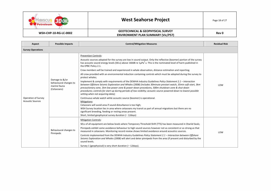
Aspect Possible Impacts Control/Mitigation Measures Residual Risk
Survey Operations
Operation of Survey Acoustic Sources
Damage to &/or behavioural changes to marine fauna (Cetaceans)
Prevention Controls:
Acoustic sources adopted for the survey are low in sound output. Only the reflective (boomer) portion of the survey has acoustic sound energy levels (SELs) above 160dB re 1µPa
2.s. This is the nominated level of harm published in
the EPBC Policy 2.1.
Crew members will be trained and experienced in whale observation, distance estimation and reporting;
All crew provided with an environmental induction containing controls which must be adopted during the survey to protect whales;
Implement & comply with requirements of the DEWHA Industry Guidelines Policy Statement 2.1 – Interaction between Offshore Seismic Exploration and Whales (2008) (includes 30minute prestart watch, 35min soft‐start, 3km precautionary zone, 1km low power zone & power‐down procedures, 500m shutdown zone & shut‐down procedures; controls for start‐up during periods of low visibility; acoustic source powered‐down to lowest possible setting when not acquiring data);
Continuous whale watch while acoustic source (boomer) is operational.
Mitigations:
Cetaceans will avoid area if sound disturbance is too high;
WSH Survey location lies in area where cetaceans my transit as part of annual migrations but there are no significant breeding, feeding or resting areas present.
Short, limited geophysical survey duration (~12days)
LOW
Behavioural changes to Pinnipeds
Mitigation Controls:
SELs of all equipment are below levels where Temporary Threshold Shift (TTS) has been measured in Otariid Seals;
Pinnipeds exhibit some avoidance behaviour to high sound sources however not as consistent or as strong as that measured in cetaceans. Monitoring record review shows limited avoidance around acoustics sources.
Controls implemented from the DEWHA Industry Guidelines Policy Statement 2.1 – Interaction between Offshore Seismic Exploration and Whales (2008) will alert and deter pinnipeds from the area (if present and disturbed by the sound levels.
Survey 1 (geophysical) is very short duration (~12days).
LOW
West Seahorse Project Page 19 of 27
WSH‐CHP‐10‐RG‐LC‐0002 GEOTECHNICAL & GEOPHYSICAL SURVEY ENVIRONMENT PLAN SUMMARY (Vic/P57)
Rev 0
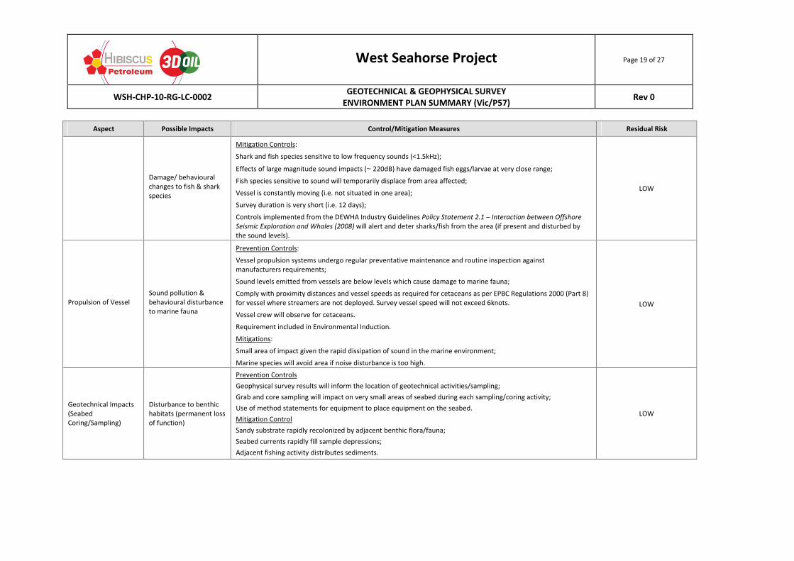
Aspect Possible Impacts Control/Mitigation Measures Residual Risk
Damage/ behavioural changes to fish & shark species
Mitigation Controls:
Shark and fish species sensitive to low frequency sounds (<1.5kHz);
Effects of large magnitude sound impacts (~220dB) have damaged fish eggs/larvae at very close range;
Fish species sensitive to sound will temporarily displace from area affected;
Vessel is constantly moving (i.e. not situated in one area);
Survey duration is very short (i.e. 12 days);
Controls implemented from the DEWHA Industry Guidelines Policy Statement 2.1 – Interaction between Offshore Seismic Exploration and Whales (2008) will alert and deter sharks/fish from the area (if present and disturbed by the sound levels).
LOW
Propulsion of Vessel Sound pollution & behavioural disturbance to marine fauna
Prevention Controls:
Vessel propulsion systems undergo regular preventative maintenance and routine inspection against manufacturers requirements;
Sound levels emitted from vessels are below levels which cause damage to marine fauna;
Comply with proximity distances and vessel speeds as required for cetaceans as per EPBC Regulations 2000 (Part 8) for vessel where streamers are not deployed. Survey vessel speed will not exceed 6knots.
Vessel crew will observe for cetaceans.
Requirement included in Environmental Induction.
Mitigations:
Small area of impact given the rapid dissipation of sound in the marine environment;
Marine species will avoid area if noise disturbance is too high.
LOW
Geotechnical Impacts (Seabed Coring/Sampling)
Disturbance to benthic habitats (permanent loss of function)
Prevention Controls
Geophysical survey results will inform the location of geotechnical activities/sampling;
Grab and core sampling will impact on very small areas of seabed during each sampling/coring activity;
Use of method statements for equipment to place equipment on the seabed.
Mitigation Control
Sandy substrate rapidly recolonized by adjacent benthic flora/fauna;
Seabed currents rapidly fill sample depressions;
Adjacent fishing activity distributes sediments.
LOW
West Seahorse Project Page 20 of 27
WSH‐CHP‐10‐RG‐LC‐0002 GEOTECHNICAL & GEOPHYSICAL SURVEY ENVIRONMENT PLAN SUMMARY (Vic/P57)
Rev 0
Aspect Possible Impacts Control/Mitigation Measures Residual Risk
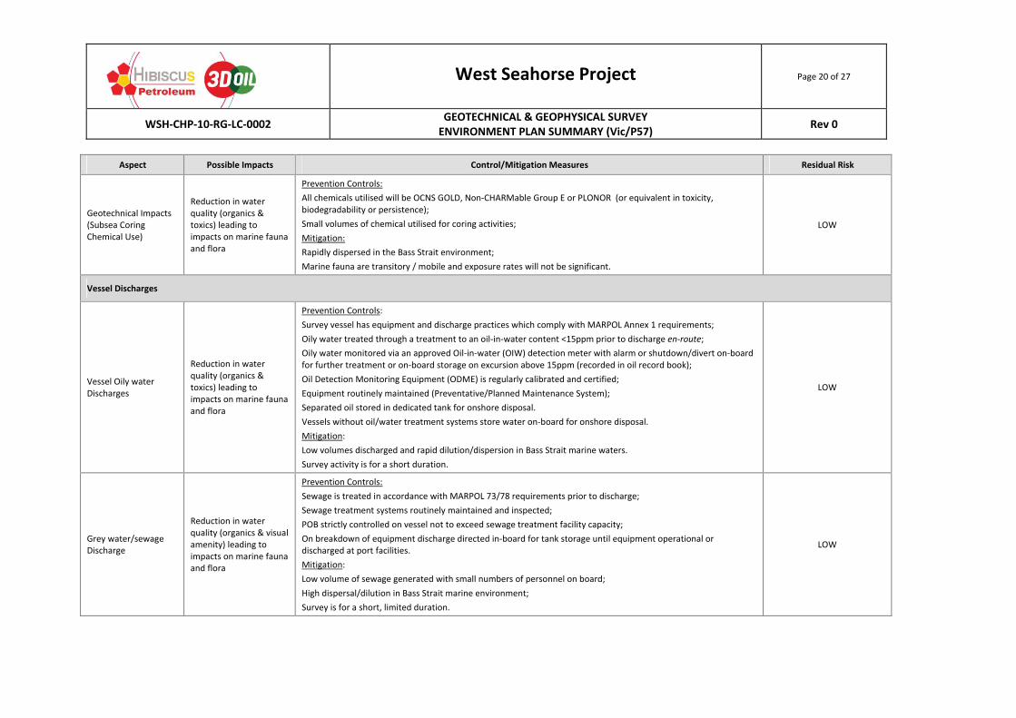
Geotechnical Impacts (Subsea Coring Chemical Use)
Reduction in water quality (organics & toxics) leading to impacts on marine fauna and flora
Prevention Controls:
All chemicals utilised will be OCNS GOLD, Non‐CHARMable Group E or PLONOR (or equivalent in toxicity, biodegradability or persistence);
Small volumes of chemical utilised for coring activities;
Mitigation:
Rapidly dispersed in the Bass Strait environment;
Marine fauna are transitory / mobile and exposure rates will not be significant.
LOW
Vessel Discharges
Vessel Oily water Discharges
Reduction in water quality (organics & toxics) leading to impacts on marine fauna and flora
Prevention Controls:
Survey vessel has equipment and discharge practices which comply with MARPOL Annex 1 requirements;
Oily water treated through a treatment to an oil‐in‐water content <15ppm prior to discharge en‐route;
Oily water monitored via an approved Oil‐in‐water (OIW) detection meter with alarm or shutdown/divert on‐board for further treatment or on‐board storage on excursion above 15ppm (recorded in oil record book);
Oil Detection Monitoring Equipment (ODME) is regularly calibrated and certified;
Equipment routinely maintained (Preventative/Planned Maintenance System);
Separated oil stored in dedicated tank for onshore disposal.
Vessels without oil/water treatment systems store water on‐board for onshore disposal.
Mitigation:
Low volumes discharged and rapid dilution/dispersion in Bass Strait marine waters.
Survey activity is for a short duration.
LOW
Grey water/sewage Discharge
Reduction in water quality (organics & visual amenity) leading to impacts on marine fauna and flora
Prevention Controls:
Sewage is treated in accordance with MARPOL 73/78 requirements prior to discharge;
Sewage treatment systems routinely maintained and inspected;
POB strictly controlled on vessel not to exceed sewage treatment facility capacity;
On breakdown of equipment discharge directed in‐board for tank storage until equipment operational or discharged at port facilities.
Mitigation:
Low volume of sewage generated with small numbers of personnel on board;
High dispersal/dilution in Bass Strait marine environment;
Survey is for a short, limited duration.
LOW
West Seahorse Project Page 21 of 27
WSH‐CHP‐10‐RG‐LC‐0002 GEOTECHNICAL & GEOPHYSICAL SURVEY ENVIRONMENT PLAN SUMMARY (Vic/P57)
Rev 0
Aspect Possible Impacts Control/Mitigation Measures Residual Risk
Putrescible waste (food‐scraps) Discharges
Reduction in water quality (organics & visual amenity) leading to impacts on marine fauna and flora
Prevention Controls:
Waste Management on board Vessels in accordance with the Vessel’s Garbage Management Plan;
Food‐scraps macerated to less than 25mm particle size in accordance with MARPOL 73/78 requirements and discharged whilst en route at distances greater than 3nm from land or frozen on‐board for onshore disposal;
Equipment routinely maintained and inspected;
Personnel trained in the requirements of the Vessel’s Waste Management Plan with placards providing on‐board guidance to personnel.
Mitigation:
Low volumes discharged and rapid dilution/dispersion in marine waters;
Survey is for a short, limited duration period.
LOW
Combustion Emissions from Vessels
Reduction in air quality (NOx, SOx, CO2) & aesthetic impacts of smoke
Prevention Controls:
Survey vessel utilises MDO/MGO which meets MARPOL Annex VI requirements for SOx emissions;
Vessel engines meet MARPOL Annex VI requirements for NOx emissions;
Regular equipment monitoring and maintenance undertaken on combustion equipment to ensure maximum efficiencies are obtained; and
Fuel usage is monitored for abnormal consumption and corrective action initiated (as required).
Mitigation:
Low volumes generated and rapid dilution/dispersion in atmosphere;
Survey is for a short limited period.
LOW
Non‐routine Activities (Incidents)
Oil spill due to tank rupture (Spill volume – largest fuel tank is 25 or 80m
3)
Toxic & Physiological impacts to marine biota (including Cetaceans, Seals & Fish)
Prevention Controls:
Survey vessel is class certified to undertake marine survey activities;
Navigational aids on survey vessel include navigation lighting, radar, radio and AIS to avoid collisions;
Vessel operated by experienced and competent crew (STWC95/Elements of Shipboard Safety) with 24/7 bridge watch;
Notice to Mariners issued by AHO;
AMSA RCC AusCoast marine warning issued;
Vessels can manoeuvre to avoid collisions;
Consultation with and notification to, marine stakeholders of activity.
Mitigation:
Availability of approved, implemented and tested SOPEP and OSCP arrangements for survey.
AMSA response to oil spill as Combat Agency for marine vessels in Commonwealth waters and Victorian DoT in Victorian Waters.
LOW
West Seahorse Project Page 22 of 27
WSH‐CHP‐10‐RG‐LC‐0002 GEOTECHNICAL & GEOPHYSICAL SURVEY ENVIRONMENT PLAN SUMMARY (Vic/P57)
Rev 0
Aspect Possible Impacts Control/Mitigation Measures Residual Risk
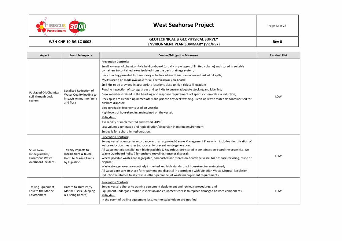
Packaged Oil/Chemical spill through deck system
Localised Reduction of Water Quality leading to impacts on marine fauna and flora
Prevention Controls:
Small volumes of chemicals/oils held on‐board (usually in packages of limited volume) and stored in suitable containers in contained areas isolated from the deck drainage system;
Deck bunding provided for temporary activities where there is an increased risk of oil spills;
MSDSs are to be made available for all chemicals/oils on‐board;
Spill kits to be provided in appropriate locations close to high‐risk spill locations;
Routine inspection of storage areas and spill kits to ensure adequate stocking and labelling;
Crew members trained in the handling and response requirements of specific chemicals via induction;
Deck spills are cleaned up immediately and prior to any deck washing. Clean‐up waste materials containerised for onshore disposal;
Biodegradable detergents used on vessels;
High levels of housekeeping maintained on the vessel.
Mitigation:
Availability of implemented and tested SOPEP
Low volumes generated and rapid dilution/dispersion in marine environment;
Survey is for a short limited duration.
LOW
Solid, Non‐biodegradable/ Hazardous Waste overboard incident
Toxicity impacts to marine flora & fauna
Harm to Marine Fauna by Ingestion
Prevention Controls:
Survey vessel operates in accordance with an approved Garage Management Plan which includes identification of waste reduction measures (at source) to prevent waste generation;
All waste materials (solid, non‐biodegradable & hazardous) are stored in containers on‐board the vessel (i.e. No Waste Overboard Policy’) for onshore recycling, reuse or disposal;
Where possible wastes are segregated, compacted and stored on‐board the vessel for onshore recycling, reuse or disposal;
Waste storage areas are routinely inspected and high standards of housekeeping maintained;
All wastes are sent to shore for treatment and disposal jn accordance with Victorian Waste Disposal legislation;
Induction reinforces to all crew (& other) personnel of waste management requirements.
LOW
Trailing Equipment Loss to the Marine Environment
Hazard to Third Party Marine Users (Shipping & Fishing Hazard)
Prevention Controls:
Survey vessel adheres to training equipment deployment and retrieval procedures; and
Equipment undergoes routine inspection and equipment checks to replace damaged or worn components.
Mitigation:
In the event of trailing equipment loss, marine stakeholders are notified.
LOW
West Seahorse Project Page 23 of 27
WSH‐CHP‐10‐RG‐LC‐0002 GEOTECHNICAL & GEOPHYSICAL SURVEY ENVIRONMENT PLAN SUMMARY (Vic/P57)
Rev 0
Aspect Possible Impacts Control/Mitigation Measures Residual Risk
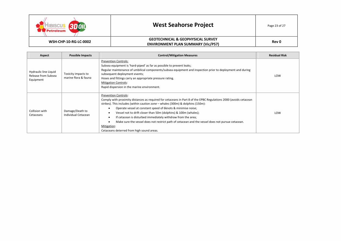
Hydraulic line Liquid Release from Subsea Equipment
Toxicity impacts to marine flora & fauna
Prevention Controls:
Subsea equipment is ‘hard‐piped’ as far as possible to prevent leaks;
Regular maintenance of umbilical components/subsea equipment and inspection prior to deployment and during subsequent deployment events;
Hoses and fittings carry an appropriate pressure rating.
Mitigation Controls:
Rapid dispersion in the marine environment.
LOW
Collision with Cetaceans
Damage/Death to Individual Cetacean
Prevention Controls:
Comply with proximity distances as required for cetaceans in Part 8 of the EPBC Regulations 2000 (avoids cetacean strikes). This includes (within caution zone – whales (300m) & dolphins (150m):
Operate vessel at constant speed of 6knots & minimise noise;
Vessel not to drift closer than 50m (dolphins) & 100m (whales);
If cetacean is disturbed immediately withdraw from the area;
Make sure the vessel does not restrict path of cetacean and the vessel does not pursue cetacean.
Mitigation:
Cetaceans deterred from high sound areas.
LOW
West Seahorse Project Page 24 of 27
WSH‐CHP‐10‐RG‐LC‐0002 GEOTECHNICAL & GEOPHYSICAL SURVEY ENVIRONMENT PLAN SUMMARY (Vic/P57)
Rev 0
6.0 SUMMARY OF MANAGEMENT APPROACH
Hibiscus, as the ‘Environmental Operator’ of the Geophysical/Geotechnical survey activity, is accountable for the environmental outcomes of the survey and will ensure that there activity is managed in accordance with the requirements of this Environment Plan. The selected survey contractor will undertake survey operations on Hibiscus’s behalf, and, under contractual arrangements with Hibiscus, will implement and comply with all environmental controls and procedures nominated in this accepted Environment Plan.
Hibiscus is committed to the protection of the environment in all activities it undertakes. Activities are undertaken in accordance with relevant legislated standards and where legislated standards do not exist, responsible standards are adopted. Successful environmental outcomes are achieved by understanding how proposed activities interact with the environment, identifying possible and foreseeable impacts, and implementing management controls which eliminate or reduce the environmental risk to a level which is As Low as Reasonably Practicable (ALARP).
Environmental performance objectives have been defined for each environmental aspect. Control measures adopted to manage the environmental risk to ALARP have been assigned measurable performance standards to ensure that controls meet their stated environmental outcomes. Environmental performance and control measure implementation is monitored and verified throughout the activity by the Hibiscus Offshore Representative.
Key elements of the implementation include:
Definition of specific roles and responsibilities as they relate to environmental protection and control implementation;
Induction activities to educate personnel of specific environmental aspects of the survey including environmental sensitivities within the region, control measures which require implementation; monitoring and reporting requirements; and ongoing communication/awareness sessions to reinforce requirements and identify/resolve possible issues;
Incident reporting and investigation of environmental incidents; and
Compliance assurance of the survey activities and its adherence to the Environment Plan requirements through auditing and inspection activities.
Hibiscus adopts a philosophy of continuous improvement. Learnings from the survey performance appraisals and incident investigations are documented and incorporated as improvement actions for future activities.
West Seahorse Project Page 25 of 27
WSH‐CHP‐10‐RG‐LC‐0002 GEOTECHNICAL & GEOPHYSICAL SURVEY ENVIRONMENT PLAN SUMMARY (Vic/P57)
Rev 0
7.0 CONSULTATION PROCESS
In accordance with the Offshore Petroleum and Greenhouse Gas Storage (Environment) Regulations 2009 R11A & R14(9) the following stakeholders and interested parties have been identified and consulted as part of the stakeholder engagements process for the survey:
Commonwealth Department or Agency
Australian Fisheries Management Authority (AFMA);
Australian Maritime Safety Authority (AMSA);
Australian Hydrographic Office (AHO);
National Offshore Petroleum Titles Administrator (NOPTA);
Department of Sustainability, Environment, Population and Communities (SEWPC);
Department of Defence;
Border Protection Command;
Department for Broadband, Communications and Digital Economy (DBCDE); and
National Native Title Tribunal (NNTT). Victorian Departments or Agencies
Department of Environment and Primary Industries (DEPI);
Department of Transport; and
Department of State Development, Business and Innovation (DSDBI). Fishing Interest Groups
Lakes Entrance Fisherman’s Cooperative Pty Ltd (LEFCOL);
South‐East Trawl Fishing Industry Association (SETFIA);
Sustainable Shark Fishing Inc.;
Southern Shark Industry Alliance;
Australian Southern Bluefin Tina Industry Association (ASBTIA);
Commonwealth Fisheries Association (CFA);
Seafood Industry Victoria (SIV);
Scallop Fishermen’s Association;
Eastern Rock Lobster Industry Association; and
VRFish. Adjacent Oil and Gas/Commercial Operators
Esso Australia Resources Pty Ltd;
Cape Energy Resources;
Telstra; and
Basslink. Feedback obtained in these consultation activities has allowed for the development of a communication and engagement strategy for each relevant stakeholder identifying the level, type, ‘triggers’ and schedule of on‐going engagement through the WSH geophysical/geotechnical survey. Hibiscus will maintain communications with stakeholders identified in this communications/engagement strategy to ensure they are informed of relevant aspects of the survey or changes that may affect them.
West Seahorse Project Page 26 of 27
WSH‐CHP‐10‐RG‐LC‐0002 GEOTECHNICAL & GEOPHYSICAL SURVEY ENVIRONMENT PLAN SUMMARY (Vic/P57)
Rev 0
8.0 CONTACT DETAILS
Further information associated with the environmental aspects of the WSH Geophysical/Geotechnical survey may be obtained from Hibiscus by contacting:
Tom Stensgaard
Carnarvon Hibiscus Pty Ltd;
Level 5/165 Flinders Lane,
Melbourne, Victoria, 3000
Telephone: 0432 696 855
Email: [email protected]
West Seahorse Project Page 27 of 27
WSH‐CHP‐10‐RG‐LC‐0002 GEOTECHNICAL & GEOPHYSICAL SURVEY ENVIRONMENT PLAN SUMMARY (Vic/P57)
Rev 0
9.0 REFERENCES
Australian Fisheries Management Authority (AFMA), 2012 – Email between Anne Duncan and L. Chapman regarding Commonwealth Fisheries in the Survey Area (29/10/12)
Australian Maritime Safety Authority (AMSA), 2013 – Email between James Bond and Leonie Chapman regarding vessel encounter in WSH Survey area (05/03/13)
Barton, J., Pope, A, and Howe, S. (2012) – Parks Victoria Technical Series No 79 – Marine Natural Values Study Vol 2: Marine Protected Areas of the Flinders and Twofold Shelf Bioregions, available at http://parkweb.vic.gov.au/__data/assets/pdf_file/0009/545517/PV_TS79_complete.pdf
Department of Environment & Primary Industries (DEPI) (2013) – Email M. Schubert to L. Chapman regarding Victorian Fisheries sent on 23/05/2013.
Department of Environment, Water, Heritage & the Arts (DEWHA), 2008 ‐ EPBC Act Policy Statement 2.1‐ Interaction between offshore seismic exploration and whales downloaded on 25/5/13 at http://www.environment.gov.au/epbc/publications/pubs/seismic‐whales.pdf
DPI, 2011 – Gippsland Basin Oil and Gas Field Map available at http://www.dpi.vic.gov.au/earth‐resources/oil‐gas/reserves‐production
Fugro, 2007 – Report for the West Seahorse 3 Site Survey, Fugro Survey Job No: P0635‐7, prepared for Australian Drilling Associates, Melbourne
National Oceans Office (NOO), 2002 – Ecosystems – Nature’s Diversity – The South‐East Regional Marine Plan Assessment Reports downloaded on 27th June 2012 at http://www.environment.gov.au/coasts/mbp/publications/south‐east/pubs/natures‐diversity.pdf
Parks Victoria, 2013 – Park Notes – Gippsland Lakes Coastal Park available at http://parkweb.vic.gov.au/__data/assets/pdf_file/0004/314572/Park‐note‐Gippsland‐Lakes‐Coastal‐Park.pdf
Parks Victoria, 2003 – Gippsland Lakes Ramsar Site Strategic Management Plan, downloaded on 24/1/13 at
http://parkweb.vic.gov.au/__data/assets/pdf_file/0007/313279/gippsland‐lakes‐ramsar‐site.pdf
SEWPC, 2013a – Protected Matters Database Search for WSH Survey Area undertaken on 4th June 2013 at www.environment.gov.au
SEWPC, 2013b – Australian National Shipwrecks Database, downloaded on 26/1/13 at https://apps5a.ris.environment.gov.au/shipwreck/public/maps/shipwreck‐map‐search‐load.do
SEWPC, 2013c – Heritage Listing – Gabo Island Lighthouse – downloaded on 15th May 2013 at http://www.environment.gov.au/cgi‐bin/ahdb/search.pl?mode=place_detail;search=state%3DVIC%3Blist_code%3DCHL%3Blegal_status%3D35%3Bkeyword_PD%3D0%3Bkeyword_SS%3D0%3Bkeyword_PH%3D0;place_id=105379
Shaughnessy, P.D. 1999 – The Action Plan for Australian Seals, accessed on 20th May 2012 @ www.environment.gov.au/coasts/publications