Embed Size (px)
Citation preview
Deep Drilling at the Arc-arc Collision Zone in the Yamakita
Area, Central Honshu, Japan
Shoji Sekiguchi+) , Hiroki Hayashi,�, Masashi Tsukui-�, Yo Uesugi.�, Tanio Ito-�, Yuichiro
Tanaka/�, Masaki Takahashi/�, Yukio Yanagisawa/�, Fumio Yamamizu+�, Kazushige Obara+�,
Sadaki Hori+�, Katsuhiko Shiomi+�, Hisanori Kimura+�, Makoto Matsubara+� and Keiji
Kasahara+�
+� National Research Institute for Earth Science and Disaster Prevention, Tsukuba,� Shimane University, Matsue-� Chiba University, Chiba.� Tsuru University, Tsuru/� Geological Survey of Japan/AIST, Tsukuba
Abstract
We carried out borehole drilling in the Yamakita area near an active fault of the arc-arc collision
zone in the western part of Kanagawa Prefecture. Slime and core samples were obtained. The
borehole geology was established by examined them using petrographic analyses and geophysical
logging data. We found that the southwestern slope of Mt. Maruyama was down-faulted from the
northern slope of the mountain by an unknown fault. After drilling was completed, the borehole
was established as a Hi-net seismic observation station. Data are collected by the Hi-net observation
system and made available through the INTERNET.
Key words� borehole drilling, Mt. Maruyama, Hinata thrust, Hi-net
+. Introduction
A collision boundary of , island-arc systems,
namely, Izu-Ogasawara and Honshu arcs, is located
at the southwestern part of the Kanto region, central
Honshu, Japan. Many active faults such as the Kozu-
Matsuda Fault are distributed in the collision zone.
It is important to obtain the detailed geologic struc-
ture of the active-fault system for estimating seismo-
genic risk in the Kanto region. The +3,- Kanto earth-
quake occurred at the upper boundary of the sub-
ducting Philippine Sea slab beneath the southern
part of the Kanto region. The seismic velocity struc-
ture at a shallow depth in the collision zone is a key
to earthquake disaster mitigation in the Kanto re-
gion.
We carried out borehole drilling in the Yamakita
area near an active fault of the arc-arc collision zone
in the western part of Kanagawa Prefecture (Fig. +).
Slime and core samples were obtained. The borehole
geology was established by examined them using
petrographic analyses and geophysical logging data.
After drilling was completed, the borehole was estab-
lished as a Hi-net seismic observation station.
,. Geological Setting
The Yamakita-Minami drilling site (-/.-//+�N,
+-3.*3.,�E, +/, m in altitude) is located on the south-
western slope of Mt. Maruyama in the Ashigara
Mountains (Figs. +, ,). The Ashigara Mountains are
located between , major Quaternary thrust systems ;
namely, the Kan’nawa and Kozu-Matsuda fault sys-
tems. The Hinata Thrust is an active fault of the
Kozu-Matsuda fault system, and is located at the
topographic boundary between Mt. Maruyama and
the Ashigara Plain (Soh, +33/).
The Ashigara Mountains are mainly composed
� � � � � � Bull. Earthq. Res. Inst.
Univ. Tokyo
Vol. 2+ ,**0� pp. ,3+�,3.
* e-mail : [email protected] (National Research Institute for Earth Science and Disaster Prevention, Tennodai -�+, Tsukuba,
Ibaraki, -*/�***0, Japan)
� 291�

of Plio-Pleistocene trough-fill deposits called Ashi-
gara Group (Amano et al., +320). The Ashigara Group
is unconformably overlain by Pleistocene Hakone
old somma (OS) and terrace deposits. Mt. Maruyama
crops out mainly as the Neishi Formation of the
lowest part of the Ashigara Group, which consists of
pyroclastic rocks and mudstone. The Neishi Forma-
tion is thought to thrust up to the southward OS
deposits through the low-angle Hinata Thrust be-
neath Mt. Maruyama.
-. Borehole Geology
At the present drilling site, whole core samples
down to +*10.0 m and . deeper spot-core samples from
a total depth of ,*-/.. m were recovered. Geophysi-
cal logging and VSP methods were conducted at the
present borehole.
The core samples are mainly composed of vol-
canic breccia, lapilli tu#, lava flow, and subordinate
conglomerate, sandstone, mudstone (Fig. -). With
respect to logging and VSP data, the present bore-
hole geology is divided into 2 units as follows in
descending order (Fig. .) :
Fig. +. Map showing the geologic setting of the
Yamakita-Minami drilling site (red star). a : Pleis-
tocene Hakone OS deposits, b : Pleistocene andestic
rocks, c : Pleistocene quartz diorite, d-g : Pliocene-
Pleistocene Ashigara Group, h : Miocene Tanzawa
Group. The geologic map is partly modified after
Amano et al. (+320).
Fig. ,. Photograph of borehole drilling at Yamakita-
Minami.
Fig. -. Core sample from /** to /*/ m in depth
(volcanic breccia of the Unit D).
Fig. .. Profile of the Yamakita-Minami borehole.
S. Sekiguchi et al.
� 292�
�Unit A (*�+-./ m in depth interval) : brown weath-
ered tephra with scoria.
�Unit B (+-./�,,+ m) : volcanic breccia and lava com-
posed of olivine basalt.
�Unit C (,,+�../ m) : volcanic breccia and lava com-
posed of olivine bearing , pyroxene basaltic andes-
ite.
�Unit D (../�1,+ m) : volcanic breccia and lava com-
posed of olivine basalt.
�Unit E (1,+�2// m) : subrounded cobblestone, sandy
lapillistone and very coarse-grained sandstone with
shell fragments and microfossils.
�Unit F (2//�+*10 m) : lava, volcanic breccia and lap-
illi tu# composed of , pyroxene andesite.
�Unit G (+*10�+-+/ m) : altered tu#aceous conglom-
erate intercalating sandstone and mudstone.
�Unit H (+-+/�,*-/.. m) : altered andesitic lava and
volcanic breccia.
Potassium-Argon and fission track ages were ob-
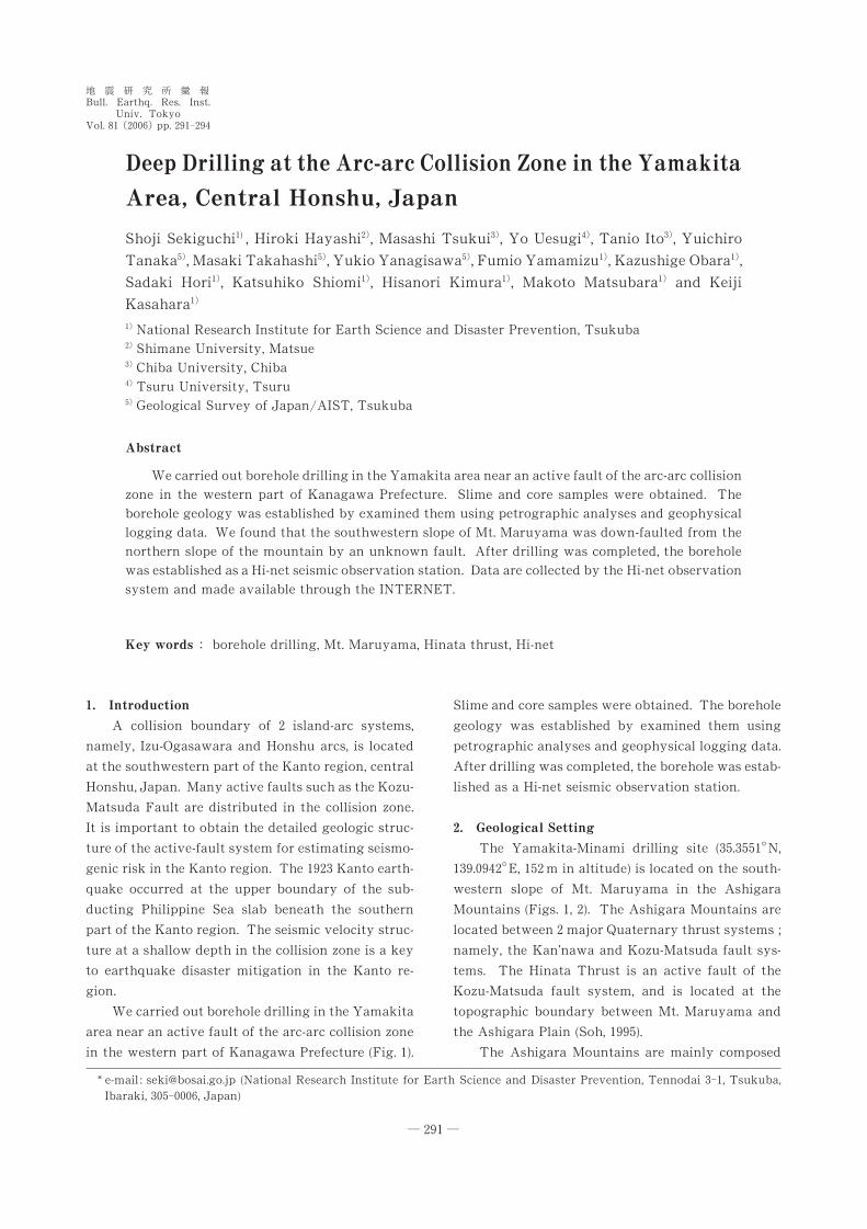
tained from 0 horizons of core samples (Fig. .). Coarse-
grained sandstone at 2-*.1/ m in depth yields calcare-
ous nannofossils, and is correlated with the zones
from CN+-b to CN+.a (+.0/ to *..+ Ma) of Okada and
Bukry (+32*) (Fig. /). According to these dating and
petrographic data, the geologic units are stratigraphi-
cally identified (Fig. .). Unit A is correlated with late
Pleistocene tephras that erupted from Fuji Volcano.
Units B, C, and D are classified into Hakone Volcano
OS deposits. Units E, F, G, and H are interpreted to be
Plio- Pleistocene basement rocks of Hakone Volcano.
The northern slope of Mt. Maruyama exposes
the Plio-Pleistocene marine deposit Neishi Formation
of the Ashigara Group. At the present borehole
geology of the southwestern slope, however, the
Pleistocene terrestrial OS deposits are distributed
from +-./ m to 1,+ m in depth. With respect to the
elevation of the present drilling site, it is suggested
that the southwestern slope of Mt. Maruyama should
be down-faulted from the northern slope of the
mountain by an unknown fault. The assumed dis-
placement of this unknown fault is at least /** m.
Assuming that the age at the base of the OS deposits
Fig. 0. Hi-net seismic observation station.
Fig. /. Calcareous nannofossils from the Yamakita-
Minami borehole. + : Pseudoemiliania lacunosa (2-2.*
m in depth), , : Gephyrocapsa caribbeanica (2-2 m), - :
Gephyrocapsa oceanica (2-*.1/ m), . : Gephyrocapsasp. (2-*.1/ m). Scale bar�- micrometers.
Deep Drilling at the Arc-arc Collision Zone in the Yamakita Area, Central Honshu, Japan
� 293�
is about *./ Ma, the average displacement rate of the
newly-suggested fault should be more than + mm/
year.
.. Installed Seismometers
After drilling was completed, seismometers of
Hi-net specifications were installed at the bottom and
the surface of the borehole (Fig. 0). Data are distrib-
uted by the Hi-net seismic observation system and
made accessible through the INTERNET (Okada et
al., ,**.). Using these data, it became possible to
obtain the seismic structures around the borehole,
such as --dimensional seismic velocity and Q struc-
tures by a seismic tomography method.
/. Conclusion
�Drilling in the Yamakita area at western part of
the Kanagawa Prefecture, we obtained the seismic
and geological profile along the borehole.
�Examining core samples and slime using petro-
graphic analyses and geophysical logging data, we
found that the southwestern slope of Mt. Ma-
ruyama is down-faulted from the northern slope of
the mountain by an unknown fault.
�The borehole was established as a Hi-net seismic
observation station after drilling was competed.
Acknowledgments
This workshop is sponsored by the Special Pro-
ject for Earthquake Disaster Mitigation in Urban
Areas from the Ministry of Education, Culture,
Sports, Science and Technology of Japan. GMT soft-
ware (Wessel and Smith, +33+) is used to draw some
of the figures.
References
Amano, K., H. Takahashi, T. Tachikawa, K. Yokoyama, C.
Yokota and J. Kikuchi, +320, Geology of Ashigara
Group�Collision tectonics of Izu micro-continent with
Eurasian plate. Essay in Geology (Prof. N. Kitamura Com-memorative Volume), pp. 1�,3.
Okada, H. and D. Bukry, +32*, Supplementary modification
and introduction of code numbers to the low-latitude
coccolith biostratigraphic zonation (Bukry, +31- ; +31/).
Mar. Micropaleontol., /, -,+�-,/.
Okada, Y., K. Kasahara, S. Hori, K. Obara, S. Sekiguchi, H.
Fujiwara and A. Yamamoto, ,**., Recent progress of
seismic observation networks in Japan �Hi-net, F-net,
K-NET and KiK-net�, Earth, Planets and Space, /0,
xv-xxviii.
Soh, W., +33/, A thrust (Hinata Fault) demarcating the
southern margin of the Ashigara Group, central Japan
and its seismotectonic implication. J. Geol. Soc. Japan,+*+, ,3/�-*-.
Wessel, P. and W.H.F. Smith, +33+, Free software helps map
and display data, Eos Trans. AGU, 1,, ..+.
(Received November ,3, ,**/)
(Accepted April +3, ,**0)
S. Sekiguchi et al.
� 294�