Embed Size (px)
Citation preview
CYNGOR CEFN GWLAD CYMRU COUNTRYSIDE COUNCIL FOR WALES
CORE MANAGEMENT PLAN INCLUDING CONSERVATION OBJECTIVES
FOR
Morfa Harlech a Morfa Dyffryn Special Area of Conservation
Version: 1.0 Date: March 2008 Approved by: Mike Willis A Welsh version of part or all of this document can be made available on request.
2
CONTENTS Preface: Purpose of this document 1. Vision for the Site 2. Site Description
2.1 Area and Designations Covered by this Plan 2.2 Outline Description 2.3 Outline of Past and Current Management 2.4 Management Units
3. The Special Features
3.1 Confirmation of Special Features 3.2 Special Features and Management Units
4. Conservation Objectives Background to Conservation Objectives 4.1 Conservation Objective for Feature 1:
Embryonic Shifting Dunes 4.2 Conservation Objective for Feature 2:
Shifting Dunes along the Shoreline with Ammophila arenaria (‘white dunes’) 4.3 Conservation Objective for Feature 3:
Dunes with Salix repens ssp. argentea (Salicion arinarea) 4.4 Conservation Objective for Feature 4:
Humid Dune Slacks 4.5 Conservation Objective for Feature 5:
Petalwort Petalophyllum ralfsii 5. Assessment of Conservation Status and Management Requirements:
5.1 Conservation Status and Management Requirements of Feature 1: Embryonic Shifting Dunes
5.2 Conservation Status and Management Requirements of Feature 2: Shifting Dunes along the Shoreline with Ammophila arenaria (‘white dunes’)
5.3 Conservation Status and Management Requirements of Feature 3: Dunes with Salix repens ssp. Argentea (Salicion arinarea)
5.4 Conservation Status and Management Requirements of Feature 4: Humid Dune Slacks
5.5 Conservation Status and Management Requirements of Feature 5: Petalwort Petalophyllum ralfsii
6. Action Plan: Summary 7. Glossary 8. References
3
PREFACE
This document provides the main elements of CCW’s management plan for the site named. It sets out what needs to be achieved on the site, the results of monitoring and advice on the action required. This document is made available through CCW’s web site and may be revised in response to changing circumstances or new information. This is a technical document that supplements summary information on the web site.
One of the key functions of this document is to provide CCW’s statement of the Conservation Objectives for the relevant Natura 2000 site. This is required to implement the Conservation (Natural Habitats, &c.) Regulations 1994, as amended (Section 4). As a matter of Welsh Assembly Government Policy, the provisions of those regulations are also to be applied to Ramsar sites in Wales.
1. VISION FOR THE SITE
This is a descriptive overview of what needs to be achieved for conservation on the site. It brings together and summarises the Conservation Objectives (part 4) into a single, integrated statement about the site. The sand dunes at Morfa Harlech and Morfa Dyffryn support a broad range of plant community types; from the naturally sparse vegetation of the strandline and the shifting dunes which grade into more fixed and stable dune communities such as the species rich mature dunes slacks and fixed dune grasslands. The mosaic of habitats, including sand dune communities, grasslands, swamp, shingle and scrub which add to the diversity of the site, should be maintained at their present level, or they could decrease in area, if the sand dunes or salt marsh increased. The natural processes which have formed both Morfa Harlech and Morfa Dyffryn sand dune systems, should be allowed to continue unimpeded. Natural debris on the strand line should be left to remain and develop into embryonic shifting dunes. Shifting dunes along the shoreline should be allowed to develop and erode naturally and the dune slacks should be allowed to form and expand, benefiting from a naturally high water table. The population of petalwort Petalophyllum ralfsii should be maintained at least at its current level, but where possible increased.
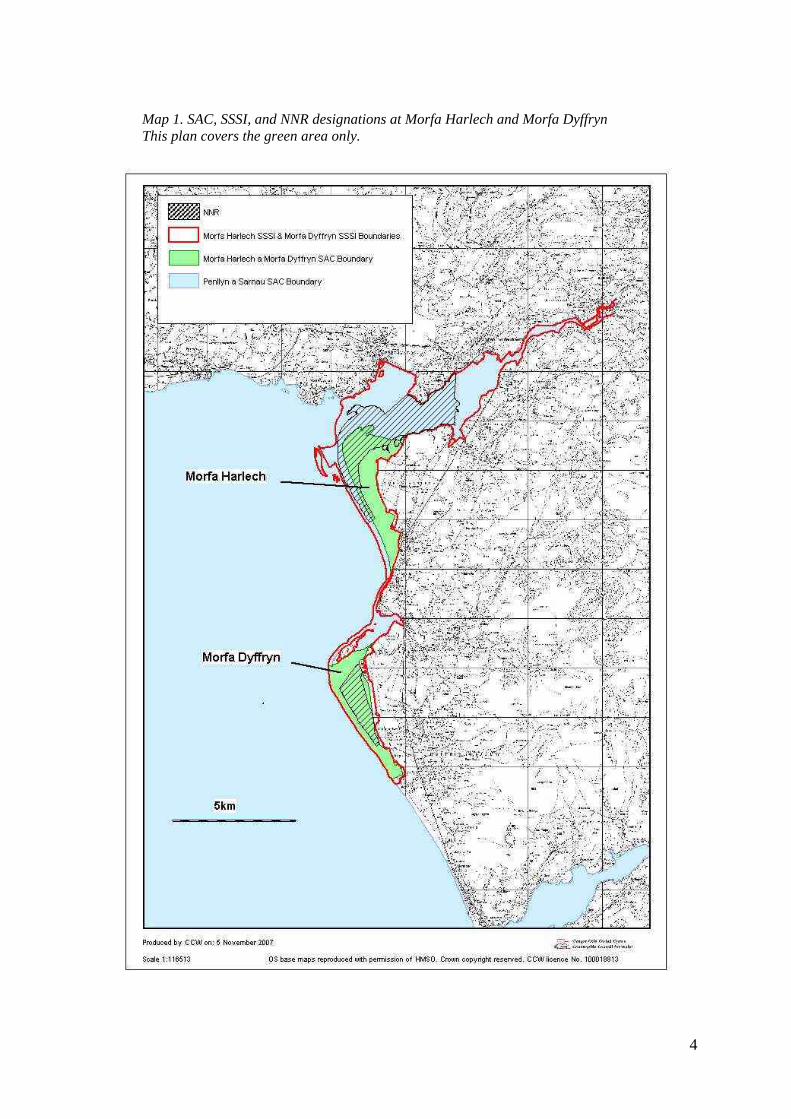
2. SITE DESCRIPTION 2.1 Area and Designations Covered by this Plan
Grid reference(s): SH560350 & SH550250 Unitary authorities: Gwynedd County Council. Area (hectares): 1,871 ha Designations covered: Morfa Harlech a Morfa Dyffryn SAC Morfa Harlech SSSI Morfa Dyffryn SSSI Morfa Harlech NNR Morfa Dyffryn NNR
4
Map 1. SAC, SSSI, and NNR designations at Morfa Harlech and Morfa Dyffryn This plan covers the green area only.
5
2.2 Outline Description
Morfa Harlech a Morfa Dyffryn SAC The Morfa Harlech a Morfa Dyffryn SAC covers two sand dune systems, Morfa Harlech to the north and Morfa Dyffryn to the south. Morfa Harlech is a rapidly accreting dune system- gaining sand from the coast to the south including the dune system at Morfa Dyffryn, which is eroding. The Morfa Harlech a Morfa Dyffryn SAC supports the following SAC features:
• Embryonic shifting dunes • Shifting dunes along the shoreline with Ammophila arenaria (‘white dunes’) • Humid dune slacks • Dunes with Salix repens ssp. argentea (Salicion arinarea) • Petalwort Petalophyllum ralfsii
The various sand dune communities will through natural processes expand at the expense of others. This may affect the extent of the component SAC features, however, the dynamic processes of the sand dunes and their associated vegetation communities is a valued aspect of the coastal dune systems. The biggest potential conflict is stabilization of dunes and the potential loss of pioneering vegetation communities to fixed dune communities.
Morfa Harlech sand dune system is accreting and is of great importance for its early successional features including its shifting and embryo dunes. The area of dunes away from the beach is very stable with little bare sand. The dune slacks at Morfa Harlech vary from drier slacks which grade into fixed dune grasslands to very damp slacks which undergo frequent flooding and support fen type vegetation communities. Although Petalophyllum ralfsii has been recorded at Morfa Harlech the lack of young slacks in this system means that the species is not abundant.
Morfa Dyffryn is an eroding system which is highly mobile. A high proportion of the site is made up of bare sand. Shifting dunes extend from the shore right through to the landward boundaries of the dune system and are punctuated by extensive dune slacks. The slack vegetation varies from pioneering embryo slack habitats, successionally young slack communities which support the bulk of the population of Petalophyllum ralfsii through to mature, species rich dune slacks.
2.3 Outline of Past and Current Management
Natural processes rather than direct management maintain the early succesional features such as the ‘embryonic shifting dunes’ and the ‘shifting dunes along the shoreline’. Morfa Harlech and Morfa Dyffryn dune systems are part of a larger coastal cell which stretches from Afon Mawddach to Morfa Bychan. Accretion and erosion rates at the dune systems are dictated by the sediment supply within this cell, therefore, off site activities such as coastal defence works which affect this sediment supply impact on the sand dunes- in particular on these early successional features; embryo dunes and shifting dunes. Coastal defence works south of the site, such as the railway embankments at Llandanwg and Llanaber and wave breaking groynes at Barmouth could all be having an effect on the sand supply.
The humid dune slacks (which support the Petalophyllum ralfsii) and the dunes with Salix repens are maintained both by management, such as grazing and scrub control, and natural factors, such as a high water table. Limited drain clearance, not affecting the features, has been consented.
6
Pressures from recreational access can have a destabilising effect on the sand dunes leading to erosion and blowouts. Such man-made erosion tends to occur at well-used access points and areas of activity such as close to camping sites and access routes from development. The causes of this type of erosion include car or motorised vehicle movement and parking, and the ‘stripe’ effect of people running up and down dunes. Such activity, along with the provision and maintenance of tracks and moving wind-blown sand can also affect dune slacks by causing erosion and compaction.
Morfa Harlech The southern part of Morfa Harlech includes areas of slack and fixed dune grassland which is managed as part of a golf course. Mowing and scrub cutting occurs in some parts of the golf course. Within the northern half of the site, both cattle and sheep graze the dune slacks, dune grasslands and salt marsh. Much of this area is designated as a National Nature Reserve (NNR). Within the NNR there is an ongoing programme of scrub clearance and some of the slacks are mown/topped occasionally. Inland, part of the dune system is planted with conifers which form part of a larger forestry plantation. The forestry plantation is likely to be affecting the water table within the adjacent dune slacks. Vehicular access is restricted to maintenance and emergency vehicles only. The main visitor access is to the dunes from the main beach car park at Harlech via public footpaths. Erosion was a problem at this location in the past; however, the installation of a boardwalk and the restriction of public access to a fenced corridor to the beach have now reversed the problem. The dunes remain accessible to the public from the beach itself and from a public footpath which crosses the dunes to the south of the site. Morfa Dyffryn The majority of Morfa Dyffryn dune system is within the same ownership, and is managed under a Tir Gofal agreement with grazing levels set for the maintenance of the dunes. This part of the SAC is currently just winter grazed by cattle. Much of the site is also an NNR. To the north of Morfa Dyffryn and within the SAC is the ‘Shell Island’ campsite which includes access tracks and rough camping in the dunes. Visitor access to the beach and the car park location here is accelerating erosion in this part of the site. Elsewhere on the site vehicle access is restricted to maintenance and emergency vehicles only. The dunes are accessible to the public from the beach and the public footpath which crosses the dune system. The main beach access point from Dyffryn Seaside Estate is along a fenced corridor through the dunes. Public access has also been controlled in the past at the main access point from the Snowdonia National Park Bennar Beach car park, however, the fencing at this access point has now been removed. This central part of the site (Unit 26) has suffered from major blowouts resulting from the unrestricted access by visitors and vehicles in the past, however, the restrictions put in place on public access and stabilisation works have now restored the damage.
Inland of the dunes, is the now closed RAF air base which falls partially within the SAC and Morfa Dyffryn SSSI. Deep drainage ditches maintained by the Environment Agency exist within the Airfield could be having an effect on the water table of the site. As part of the NNR management there is an ongoing programme of scrub clearance on the site. Rabbit grazing is important in maintaining dune vegetation; however the rabbit populations within the dune systems do fluctuate due to outbreaks of myxomatosis and rabbit viral haemorrhagic disease (RDHV) resulting in changes to the vegetation.
7
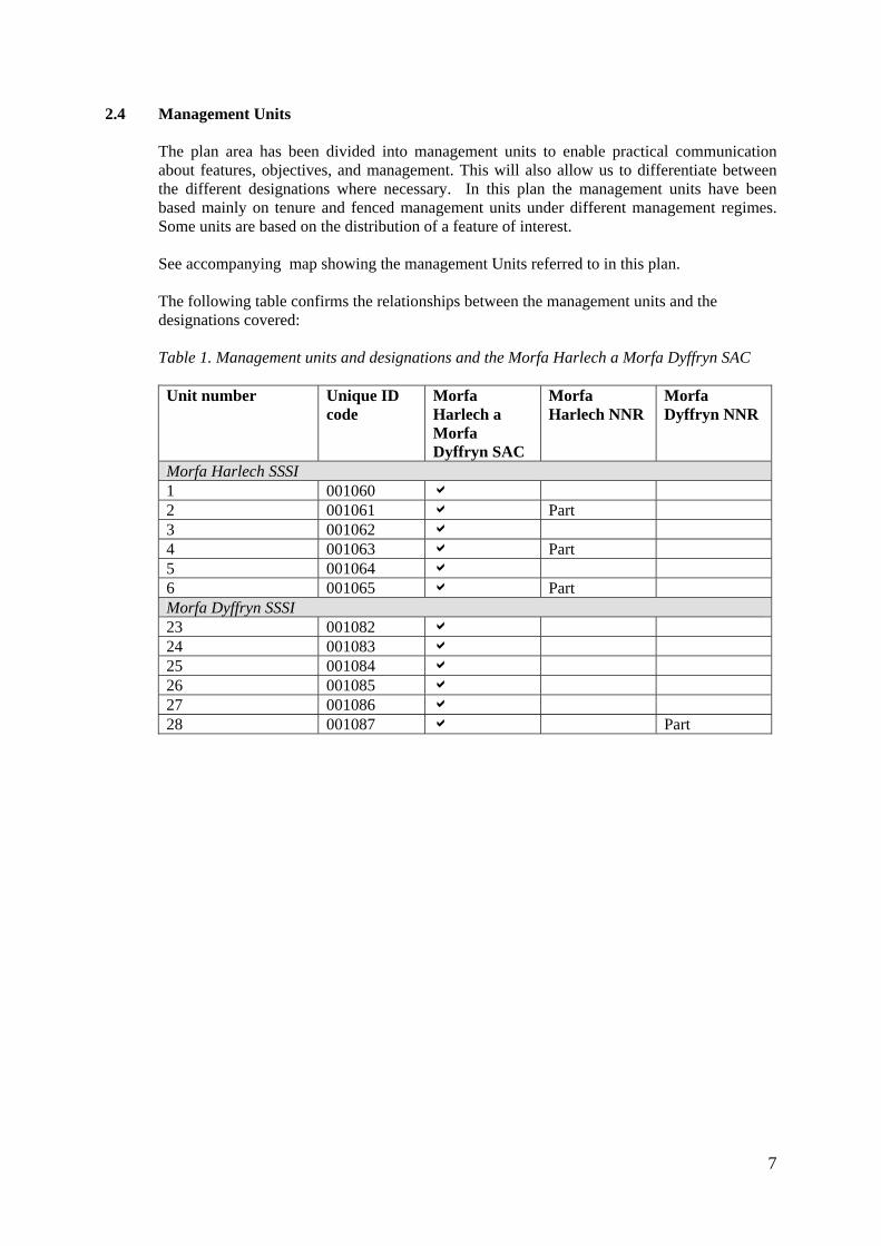
2.4 Management Units The plan area has been divided into management units to enable practical communication about features, objectives, and management. This will also allow us to differentiate between the different designations where necessary. In this plan the management units have been based mainly on tenure and fenced management units under different management regimes. Some units are based on the distribution of a feature of interest. See accompanying map showing the management Units referred to in this plan. The following table confirms the relationships between the management units and the designations covered:
Table 1. Management units and designations and the Morfa Harlech a Morfa Dyffryn SAC
Unit number
Unique ID code
Morfa Harlech a Morfa Dyffryn SAC
Morfa Harlech NNR
Morfa Dyffryn NNR
Morfa Harlech SSSI 1 001060 a 2 001061 a Part 3 001062 a 4 001063 a Part 5 001064 a 6 001065 a Part Morfa Dyffryn SSSI 23 001082 a 24 001083 a 25 001084 a 26 001085 a 27 001086 a 28 001087 a Part
8
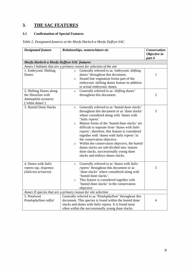
3. THE SAC FEATURES 3.1 Confirmation of Special Features Table 2. Designated features at the Morfa Harlech a Morfa Dyffryn SAC Designated feature Relationships, nomenclature etc Conservation
Objective in part 4
Morfa Harlech a Morfa Dyffryn SAC features Annex I habitats that are a primary reason for selection of the site 1. Embryonic Shifting Dunes
o Generally referred to as ‘embryonic shifting dunes’ throughout this document.
o Strand line vegetation forms part of the embryonic shifting dunes feature in addition to actual embryonic dunes.
1
2. Shifting Dunes along the Shoreline with Ammophila arenaria (‘white dunes’)
o Generally referred to as ‘shifting dunes’ throughout this document.
2
3. Humid Dune Slacks o Generally referred to as ‘humid dune slacks’ throughout this document or as ‘dune slacks’ where considered along with ‘dunes with ‘Salix repens’
o Mature forms of the ‘humid dune slacks’ are difficult to separate from ‘dunes with Salix repens’, therefore, this feature is considered together with ‘dunes with Salix repens’ in the conservation objective.
o Within the conservation objective, the humid dunes slacks are sub-divided into: mature dune slacks, successionally young dune slacks and embryo dunes slacks.
3
4. Dunes with Salix repens ssp. Argentea (Salicion arinarea)
o Generally referred to as ‘dunes with Salix repens’ throughout this document or as ‘dune slacks’ where considered along with ‘humid dune slacks’.
o This feature is considered together with ‘humid dune slacks’ in the conservation objective
3
Annex II species that are a primary reason for site selection 5. Petalwort Petalophyllum ralfsii
Generally referred to as ‘Petalophyllum’ throughout this document. This species is found within the humid dune slacks and dunes with Salix repens. It is found most often within the successionally young dune slacks.
4
9
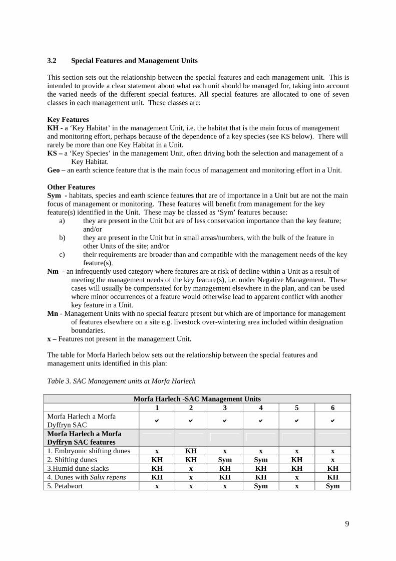
3.2 Special Features and Management Units This section sets out the relationship between the special features and each management unit. This is intended to provide a clear statement about what each unit should be managed for, taking into account the varied needs of the different special features. All special features are allocated to one of seven classes in each management unit. These classes are: Key Features KH - a ‘Key Habitat’ in the management Unit, i.e. the habitat that is the main focus of management and monitoring effort, perhaps because of the dependence of a key species (see KS below). There will rarely be more than one Key Habitat in a Unit. KS – a ‘Key Species’ in the management Unit, often driving both the selection and management of a
Key Habitat. Geo – an earth science feature that is the main focus of management and monitoring effort in a Unit. Other Features Sym - habitats, species and earth science features that are of importance in a Unit but are not the main focus of management or monitoring. These features will benefit from management for the key feature(s) identified in the Unit. These may be classed as ‘Sym’ features because:
a) they are present in the Unit but are of less conservation importance than the key feature; and/or
b) they are present in the Unit but in small areas/numbers, with the bulk of the feature in other Units of the site; and/or
c) their requirements are broader than and compatible with the management needs of the key feature(s).
Nm - an infrequently used category where features are at risk of decline within a Unit as a result of meeting the management needs of the key feature(s), i.e. under Negative Management. These cases will usually be compensated for by management elsewhere in the plan, and can be used where minor occurrences of a feature would otherwise lead to apparent conflict with another key feature in a Unit.
Mn - Management Units with no special feature present but which are of importance for management of features elsewhere on a site e.g. livestock over-wintering area included within designation boundaries.
x – Features not present in the management Unit. The table for Morfa Harlech below sets out the relationship between the special features and management units identified in this plan: Table 3. SAC Management units at Morfa Harlech
Morfa Harlech -SAC Management Units 1 2 3 4 5 6 Morfa Harlech a Morfa Dyffryn SAC a a a a a a Morfa Harlech a Morfa Dyffryn SAC features
1. Embryonic shifting dunes x KH x x x x 2. Shifting dunes KH KH Sym Sym KH x 3.Humid dune slacks KH x KH KH KH KH 4. Dunes with Salix repens KH x KH KH x KH 5. Petalwort x x x Sym x Sym

10
Table 4. SAC Management units at Morfa Dyffryn
Morfa Dyffryn SSSI Management Units 23 24 25 26 27 28 Morfa Harlech a Morfa Dyffryn SAC a a a a a a Morfa Harlech a Morfa Dyffryn SAC Features
1. Embryo dunes x x x x x x 2. Shifting dunes KH KH x KH x KH 3.Humid dune slacks Sym x x KH KH KH 4. Dunes with Salix repens Sym x x KH KH KH 5. Petalwort x x x KS x KS 4. CONSERVATION OBJECTIVES
Background to Conservation Objectives:
a. Outline of the legal context and purpose of conservation objectives.
Conservation objectives are required by the 1992 ‘Habitats’ Directive (92/43/EEC). The aim of the Habitats Directives is the maintenance, or where appropriate the restoration of the ‘favourable conservation status’ of habitats and species features for which SACs and SPAs are designated (see Box 1). In the broadest terms, 'favourable conservation status' means a feature is in satisfactory condition and all the things needed to keep it that way are in place for the foreseeable future. CCW considers that the concept of favourable conservation status provides a practical and legally robust basis for conservation objectives for Natura 2000 and Ramsar sites.
Box 1 Favourable conservation as defined in Articles 1(e) and 1(i) of the Habitats Directive “The conservation status of a natural habitat is the sum of the influences acting on it and its typical species that may affect its long-term natural distribution, structure and functions as well as the long term survival of its typical species. The conservation status of a natural habitat will be taken as favourable when:
• Its natural range and areas it covers within that range are stable or increasing, and • The specific structure and functions which are necessary for its long-term
maintenance exist and are likely to continue to exist for the foreseeable future, and • The conservation status of its typical species is favourable.
The conservation status of a species is the sum of the influences acting on the species that may affect the long-term distribution and abundance of its populations. The conservation status will be taken as ‘favourable’ when:
• population dynamics data on the species indicate that it is maintaining itself on a
long-term basis as a viable component of its natural habitats, and • the natural range of the species is neither being reduced nor is likely to be reduced
for the foreseeable future, and • There is, and will probably continue to be, a sufficiently large habitat to maintain
its populations on a long-term basis.”
11
Achieving these objectives requires appropriate management and the control of factors that may cause deterioration of habitats or significant disturbance to species. As well as the overall function of communication, Conservation objectives have a number of specific roles: • Conservation planning and management.
The conservation objectives guide management of sites, to maintain or restore the habitats and species in favourable condition.
• Assessing plans and projects. Article 6(3) of the ‘Habitats’ Directive requires appropriate assessment of proposed plans and projects against a site's conservation objectives. Subject to certain exceptions, plans or projects may not proceed unless it is established that they will not adversely affect the integrity of sites. This role for testing plans and projects also applies to the review of existing decisions and consents.
• Monitoring and reporting.
The conservation objectives provide the basis for assessing the condition of a feature and the status of factors that affect it. CCW uses ‘performance indicators’ within the conservation objectives, as the basis for monitoring and reporting. Performance indicators are selected to provide useful information about the condition of a feature and the factors that affect it.
The conservation objectives in this document reflect CCW’s current information and understanding of the site and its features and their importance in an international context. The conservation objectives are subject to review by CCW in light of new knowledge. b. Format of the conservation objectives There is one conservation objective for each feature listed in part 3. Each conservation objective is a composite statement representing a site-specific description of what is considered to be the favourable conservation status of the feature. These statements apply to a whole feature as it occurs within the whole plan area, although section 3.2 sets out their relevance to individual management Units. Each conservation objective consists of the following two elements:
1. Vision for the feature 2. Performance indicators
As a result of the general practice developed and agreed within the UK Conservation Agencies, conservation objectives include performance indicators, the selection of which should be informed by JNCC guidance on Common Standards Monitoring1. There is a critical need for clarity over the role of performance indicators within the conservation objectives. A conservation objective, because it includes the vision for the
1 Available through www.jncc.gov.uk and follow links to Protected Sites and Common Standards Monitoring.

12
feature, has meaning and substance independently of the performance indicators, and is more than the sum of the performance indicators. The performance indicators are simply what make the conservation objectives measurable, and are thus part of, not a substitute for, the conservation objectives. Any feature attribute identified in the performance indicators should be represented in the vision for the feature, but not all elements of the vision for the feature will necessarily have corresponding performance indicators. As well as describing the aspirations for the condition of the feature, the Vision section of each conservation objective contains a statement that the factors necessary to maintain those desired conditions are under control. Subject to technical, practical and resource constraints, factors which have an important influence on the condition of the feature are identified in the performance indicators.
13
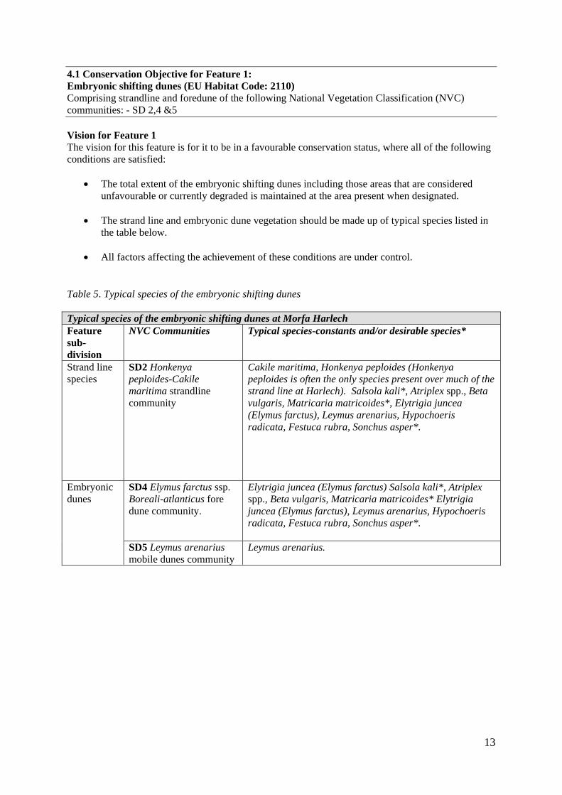
4.1 Conservation Objective for Feature 1: Embryonic shifting dunes (EU Habitat Code: 2110) Comprising strandline and foredune of the following National Vegetation Classification (NVC) communities: - SD 2,4 &5 Vision for Feature 1 The vision for this feature is for it to be in a favourable conservation status, where all of the following conditions are satisfied:
• The total extent of the embryonic shifting dunes including those areas that are considered unfavourable or currently degraded is maintained at the area present when designated.
• The strand line and embryonic dune vegetation should be made up of typical species listed in
the table below.
• All factors affecting the achievement of these conditions are under control. Table 5. Typical species of the embryonic shifting dunes Typical species of the embryonic shifting dunes at Morfa Harlech Feature sub-division
NVC Communities Typical species-constants and/or desirable species*
Strand line species
SD2 Honkenya peploides-Cakile maritima strandline community
Cakile maritima, Honkenya peploides (Honkenya peploides is often the only species present over much of the strand line at Harlech). Salsola kali*, Atriplex spp., Beta vulgaris, Matricaria matricoides*, Elytrigia juncea (Elymus farctus), Leymus arenarius, Hypochoeris radicata, Festuca rubra, Sonchus asper*.
SD4 Elymus farctus ssp. Boreali-atlanticus fore dune community.
Elytrigia juncea (Elymus farctus) Salsola kali*, Atriplex spp., Beta vulgaris, Matricaria matricoides* Elytrigia juncea (Elymus farctus), Leymus arenarius, Hypochoeris radicata, Festuca rubra, Sonchus asper*.
Embryonic dunes
SD5 Leymus arenarius mobile dunes community
Leymus arenarius.
14
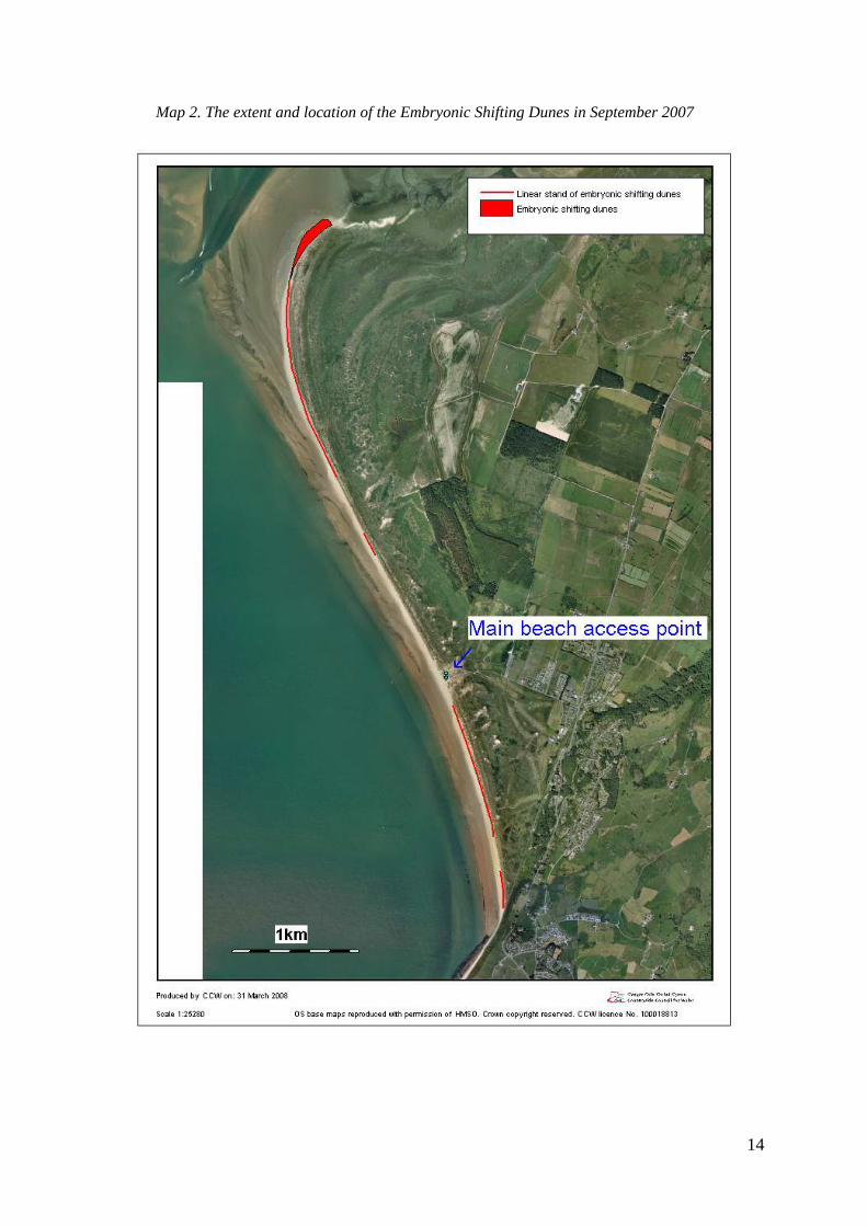
Map 2. The extent and location of the Embryonic Shifting Dunes in September 2007
15
Performance indicators for Feature 1 The performance indicators are part of the conservation objective, not a substitute for it. Assessment of plans and projects must be based on the entire conservation objective, not just the performance indicators. Table 6 Performance indicators for feature condition: Embryonic Shifting Dunes Attribute Attribute, rationale and other comments Specified limits
A1. Extent of Embryonic Shifting Dunes.
The extent target is based on the extent of the strand line from monitoring visits in 2002 and 2007 (not the extent when designated). Embryonic dunes and strand line vegetation can be destroyed or damaged by natural processes such as storms and high tides. Therefore, to expect it to be present every year is unrealistic. However, monitoring by the site wardens between 1987 and 1997 shows the strand line was present for ten out of eleven of those years. There is no specific target for embryonic shifting dunes at Morfa Dyffryn because they are not normally present, however, if they do form they tend to be insignificant in extent. Definitions: Strandline vegetation: typical strand line species on the seaward side of the first dune ridge at a density of at least one plant every 5 metres. Embryo dunes: sparsely vegetated mobile sand hummocks up to 1m high on the seaward side of the first dune ridge. At Morfa Harlech these two habitats tend to merge together. A map showing the distribution of the embryonic shifting dunes in 2007 is shown below (Map 3). A decrease in the extent of the embryonic dunes due to natural processes is acceptable. A decrease found to be the result of anthropogenic factors is not.
Within Unit 2 Morfa Harlech, where embryonic shifting dunes is the key habitat: • Embryonic shifting
dunes should be present along at least 700m of the beach with at least 50m present south of the main beach access point. The strand line and embryo dunes should be present during late summer (August and September)
• Absence of this feature due to exceptionally high tides or storms is acceptable.
16
A2. Condition of embryonic shifting dunes: species composition.
These targets are based on the Common Standards Monitoring (CSM) attribute for this feature. Modified according to site-specific requirements. The CSM guidelines suggests for the strandline that one the typical species should be frequent and a second occasional for both embryonic dunes and strand line vegetation. However, strand line vegetation varies from year to year and although unlikely, it could be possible for the strand line vegetation to be made up of a singular species over a significant stretch. The embryo dune vegetation can also be defined by a singular species.
• The embryonic shifting dunes should be vegetated by at least one species typical of embryo dunes or of strand line vegetation.
• Typical species of these
habitats are listed above.
Table 7. Performance indicators for factors affecting the feature: Embryonic Shifting Dunes Factor Factor rationale and other comments Operational Limits F1. Physical structure- functionality and sediment supply from both on site and off site
A continuous supply of fresh blown sand is essential for the maintenance of this early successional habitat. Without the fresh supply of sand the strand line and embryo dunes are likely to erode. The sand balance on the site is a direct consequence of the balance within the coastal cell which stretches from the Mawddach to Morfa Bychan. The Morfa Harlech dune system is gaining sand from the eroding system at Morfa Dyffryn. Recording sand levels using the beach markers has shown net accretion at the north and far south of Morfa Harlech since 1987. Geomorphological modelling of the site (Pye and Saye 2005) predicts continued accretion in the north only (by 2080-2100) with the coastline of the southern half of the site retreating inland slightly. The targets in the performance indicator currently stipulate that accretion in the south is currently desirable; however, this target may need to be reconsidered in the future. The natural erosion of sand and other substrates will be tolerated. However, erosion due to human activities will not be.
Within the coastal cell and within Morfa Harlech a Dyffryn dune systems; Units 1–6 and 23–28: • There should be no further
anthropogenic increase in factors leading to constraints to the natural mobility of the system. These could include; new coastal defence works or beach stabilisation works.
• There should be net accretion
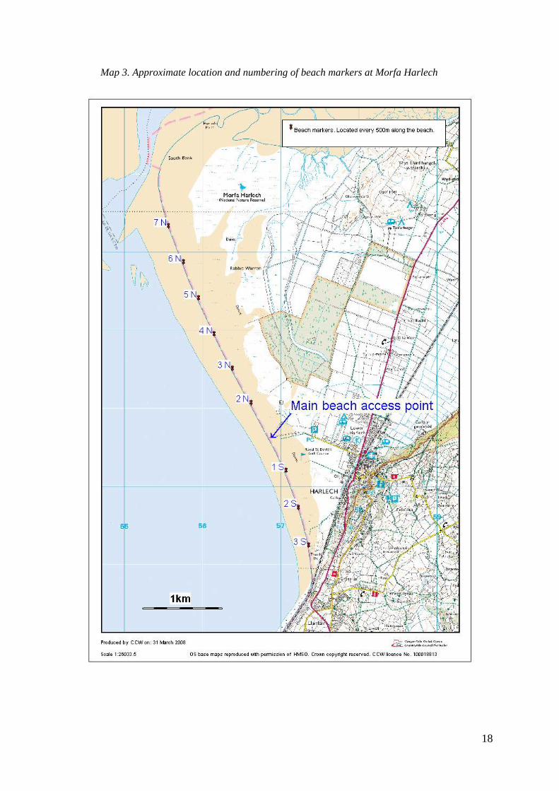
recorded over a five-year period at the permanent beach markers south of the main beach access point (1-3 S) and markers north of northing gridline 33 (5, 6 and 7 N) (See map below).
17
F2. Beach cleaning Organic matter on the beach helps to trap the blown sand and act as a nutrient and moisture source for strand line vegetation. Unselective beach cleaning has lead to the removal of organic matter such as seaweed from beaches elsewhere.
On the beaches; Unit 2 Morfa Harlech and Units 23, 24, 26 and 28 at Morfa Dyffryn • If beach cleaning occurs no
organic matter such as seaweed should be removed.
F3. Vehicle or visitor damage
This target is based on the Common Standards Monitoring (CSM) attribute for this feature.
Within Unit 2 where embryonic shifting dunes is the key habitat: • Vehicle or visitor damage
should be absent or rare.
F5. Grazing This target has been included because damage to the strand line vegetation caused by grazing has been observed at Morfa Harlech.
Within Unit 2 where embryonic shifting dunes is the key habitat: • Damage to vegetation due to
grazing or trampling should be rare or absent.
18
Map 3. Approximate location and numbering of beach markers at Morfa Harlech
19
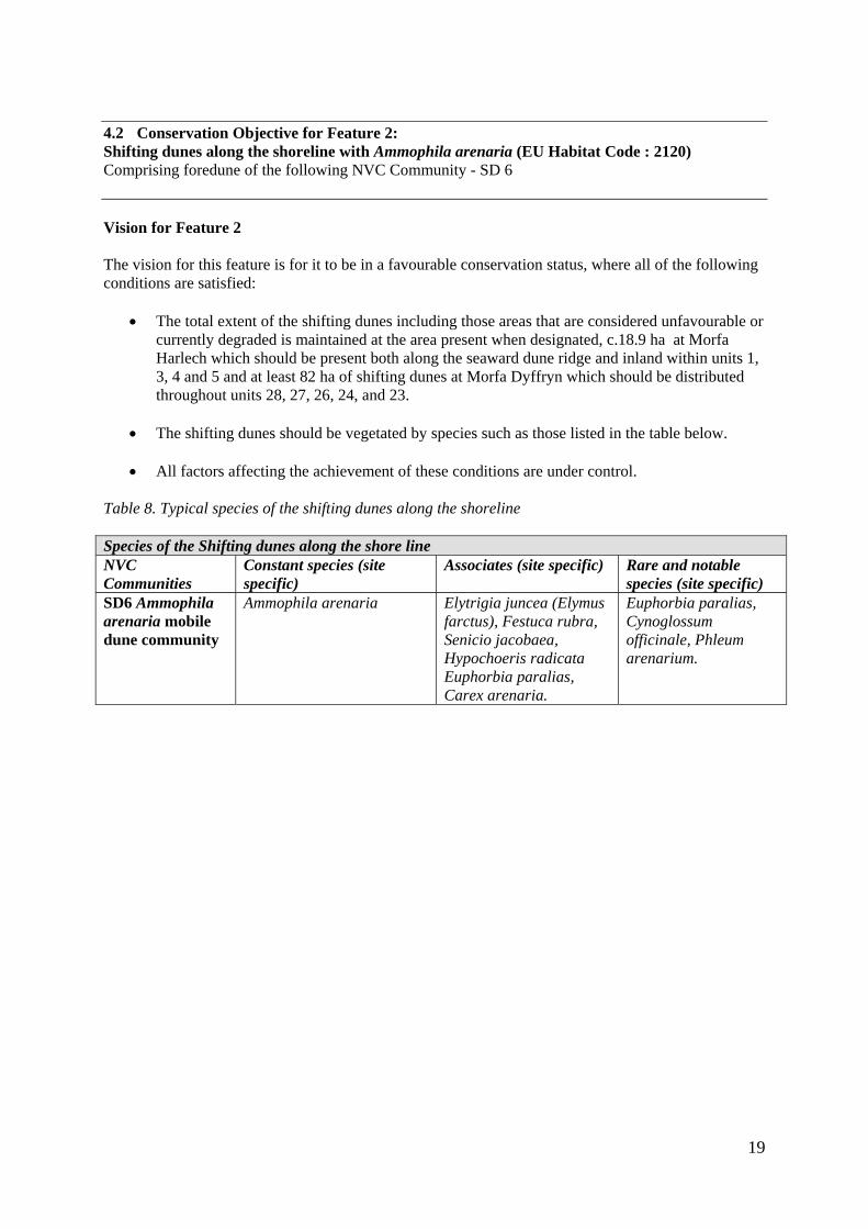
4.2 Conservation Objective for Feature 2: Shifting dunes along the shoreline with Ammophila arenaria (EU Habitat Code : 2120) Comprising foredune of the following NVC Community - SD 6 Vision for Feature 2 The vision for this feature is for it to be in a favourable conservation status, where all of the following conditions are satisfied:
• The total extent of the shifting dunes including those areas that are considered unfavourable or currently degraded is maintained at the area present when designated, c.18.9 ha at Morfa Harlech which should be present both along the seaward dune ridge and inland within units 1, 3, 4 and 5 and at least 82 ha of shifting dunes at Morfa Dyffryn which should be distributed throughout units 28, 27, 26, 24, and 23.
• The shifting dunes should be vegetated by species such as those listed in the table below.
• All factors affecting the achievement of these conditions are under control.
Table 8. Typical species of the shifting dunes along the shoreline Species of the Shifting dunes along the shore line NVC Communities
Constant species (site specific)
Associates (site specific) Rare and notable species (site specific)
SD6 Ammophila arenaria mobile dune community
Ammophila arenaria
Elytrigia juncea (Elymus farctus), Festuca rubra, Senicio jacobaea, Hypochoeris radicata Euphorbia paralias, Carex arenaria.
Euphorbia paralias, Cynoglossum officinale, Phleum arenarium.
20
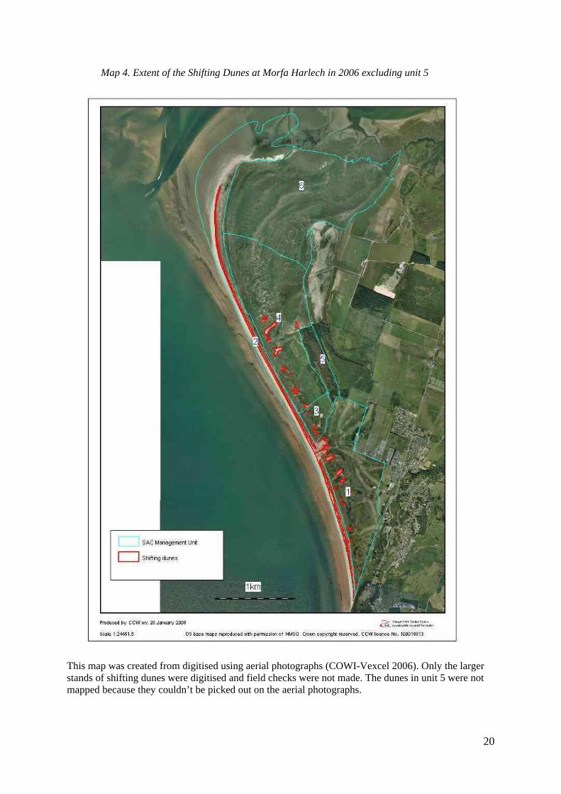
Map 4. Extent of the Shifting Dunes at Morfa Harlech in 2006 excluding unit 5
This map was created from digitised using aerial photographs (COWI-Vexcel 2006). Only the larger stands of shifting dunes were digitised and field checks were not made. The dunes in unit 5 were not mapped because they couldn’t be picked out on the aerial photographs.

21
Map 5. Extent of the Shifting Dunes at Morfa Dyffryn in 2006
This map was created from digitised using aerial photographs (COWI-Vexcel 2006). Only the larger stands of shifting dunes were digitised and field checks were not made.

22
Table 9: Performance indicators for feature condition: Shifting dunes Attribute Attribute rationale and other
comments Specified limits
A1. Extent of Shifting Dunes.
The targets are based on the features of interest sheet. Shifting dunes definition: Dunes made up of bare sand or open communities dominated by Ammophila arenaria, or Elytrigia juncea, with bare sand present throughout the sward. Maps showing the existing extent of the shifting dunes are shown above (Maps 4 and 5). A decrease in the extent of the shifting dunes due to natural processes is acceptable. A decrease found to be the result of anthropogenic factors is not.
Morfa Harlech • There should be at least 18.9 ha of shifting dunes
at Morfa Harlech spread throughout units 1, 2, 3, 4, and 5.
• At least 4 ha of shifting dunes should be spread throughout Units 1,3,4 and 5 (away from the seaward dune ridge), including at least two areas of shifting dunes greater than 0.4 ha in extent. This should not include areas of disturbed bare sand created as a result of tracks or works on the dunes.
• Within Unit 2, Morfa Harlech, there should be a ridge of shifting dunes for 5000m along the beachfront.
Morfa Dyffryn • There should be at least 79ha of shifting dunes.
At Morfa Dyffryn (Units 23, 24, 26, 27 and 28)
A2. Condition of shifting dunes: species composition.
Clematis vitalba is an invasive species associated with increased atmospheric nitrogen deposition and low grazing levels. It is currently present at Morfa Harlech.
Throughout Morfa Harlech a Morfa Dyffryn SAC: Upper limit: • The shifting dunes should be vegetated primarily
by Ammophila arenaria or Elytrigia juncea and other species typical of the shifting dunes at Morfa Harlech and Morfa Dyffryn listed within table 8 above.
• Within the shifting dunes no dense stands of Clematis vitalba larger than 1m x 1m should be present.
23
Table 10. Performance indicators for factors affecting the feature: Shifting dunes Factor Factor rationale and other comments Operational Limits F1. Physical structure- functionality and sediment supply
A continuous supply of fresh blown sand is essential for the maintenance of the accreting dunes at Morfa Harlech. Cessation of the supply of fresh sand could lead to stabilisation or erosion. A further decrease in the sand supply at Morfa Dyffryn could lead to an unnatural increase in the rate of erosion. The sand balance on the site is a direct consequence of the balance within the coastal cell stretching from the Mawddach to Morfa Bychan. The natural erosion of sand and other substrates will be tolerated. However, erosion due to human activities will not be.
Within the coastal cell and within Morfa Harlech a Dyffryn dune systems; Units 1-6 and 23-28: • There should be no further anthropogenic
increase in factors leading to constraints to the natural mobility of the system. These could include; new coastal defence works or beach stabilisation works.
• Within Unit 2, Morfa Harlech, there
should be net accretion recorded over every five year period for beach markers 1, 2 and 3 south of the main beach access point and markers 5, 6 and 7 to the north of northing gridline 33.
F2. Beach cleaning
Organic matter on the beach helps to trap the blown sand and act as a nutrient and moisture source for strand line vegetation which builds into embryo dunes and on into shifting dunes. Unselective beach cleaning has lead to the removal of organic matter such as seaweed from beaches elsewhere.
On the beaches; Unit 2 Morfa Harlech and Units 23, 24, 26 and 28 at Morfa Dyffryn • If beach cleaning occurs no organic
matter such as seaweed should be removed.
F3. Grazing, and disturbance by livestock
Grazing and trampling can help keep the shifting dune vegetation open and the dunes mobile. However, heavy grazing can have a detrimental effect.
• The dunes should be lightly grazed. • Within Units 6, 4 and 3 grazing levels are
stipulated in the management agreement for the holding.
• Unit 26, grazing levels are stipulated in the Tir Gofal agreement for the holding.
F4. Grazing and digging by rabbits
Rabbits digging and grazing help keep mobile dunes mobile and destabilise fixed dunes creating new shifting dune habitat.
No limits set
F5. Vehicle or visitor damage
Pressure from trampling or vehicles can cause damage to vegetation and erosion.
Within units 1, 3, 4, 28, 26, 23 and 24 • Vehicle or visitor damage should be
absent or rare.
F6. Forestry Plantation
The forestry plantation within Unit 5 has fossilised the once mobile dunes.
Within Unit 5 • The coniferous trees should be removed.
24
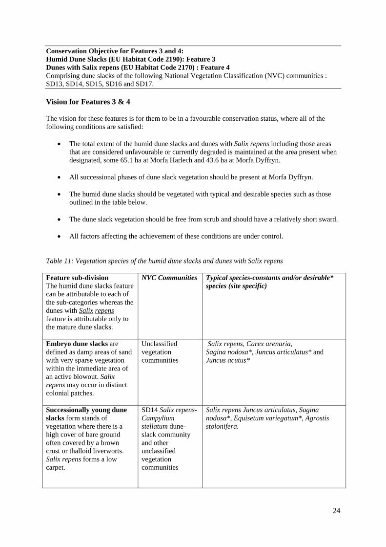
Conservation Objective for Features 3 and 4: Humid Dune Slacks (EU Habitat Code 2190): Feature 3 Dunes with Salix repens (EU Habitat Code 2170) : Feature 4 Comprising dune slacks of the following National Vegetation Classification (NVC) communities : SD13, SD14, SD15, SD16 and SD17. Vision for Features 3 & 4 The vision for these features is for them to be in a favourable conservation status, where all of the following conditions are satisfied:
• The total extent of the humid dune slacks and dunes with Salix repens including those areas
that are considered unfavourable or currently degraded is maintained at the area present when designated, some 65.1 ha at Morfa Harlech and 43.6 ha at Morfa Dyffryn.
• All successional phases of dune slack vegetation should be present at Morfa Dyffryn.
• The humid dune slacks should be vegetated with typical and desirable species such as those
outlined in the table below.
• The dune slack vegetation should be free from scrub and should have a relatively short sward.
• All factors affecting the achievement of these conditions are under control. Table 11: Vegetation species of the humid dune slacks and dunes with Salix repens Feature sub-division The humid dune slacks feature can be attributable to each of the sub-categories whereas the dunes with Salix repens feature is attributable only to the mature dune slacks.
NVC Communities Typical species-constants and/or desirable* species (site specific)
Embryo dune slacks are defined as damp areas of sand with very sparse vegetation within the immediate area of an active blowout. Salix repens may occur in distinct colonial patches.
Unclassified vegetation communities
Salix repens, Carex arenaria, Sagina nodosa*, Juncus articulatus* and Juncus acutus*
Successionally young dune slacks form stands of vegetation where there is a high cover of bare ground often covered by a brown crust or thalloid liverworts. Salix repens forms a low carpet.
SD14 Salix repens- Campylium stellatum dune-slack community and other unclassified vegetation communities
Salix repens Juncus articulatus, Sagina nodosa*, Equisetum variegatum*, Agrostis stolonifera.
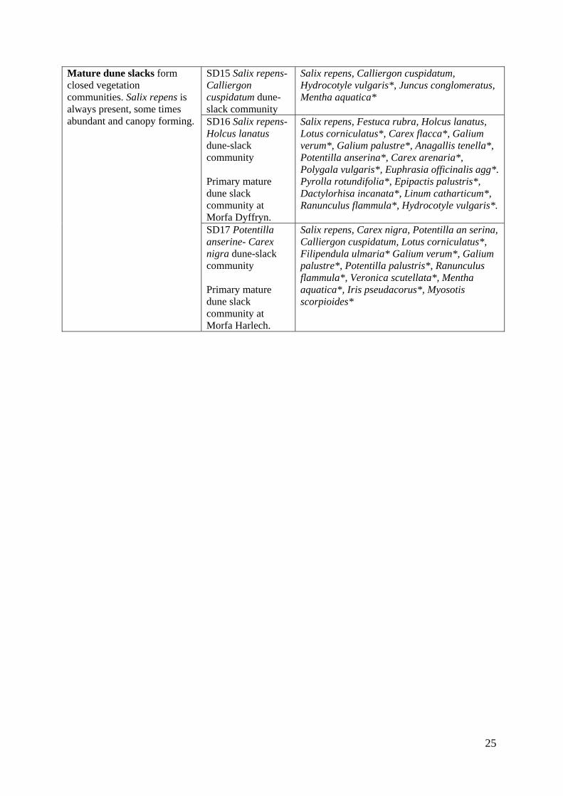
25
SD15 Salix repens- Calliergon cuspidatum dune-slack community
Salix repens, Calliergon cuspidatum, Hydrocotyle vulgaris*, Juncus conglomeratus, Mentha aquatica*
SD16 Salix repens- Holcus lanatus dune-slack community Primary mature dune slack community at Morfa Dyffryn.
Salix repens, Festuca rubra, Holcus lanatus, Lotus corniculatus*, Carex flacca*, Galium verum*, Galium palustre*, Anagallis tenella*, Potentilla anserina*, Carex arenaria*, Polygala vulgaris*, Euphrasia officinalis agg*. Pyrolla rotundifolia*, Epipactis palustris*, Dactylorhisa incanata*, Linum catharticum*, Ranunculus flammula*, Hydrocotyle vulgaris*.
Mature dune slacks form closed vegetation communities. Salix repens is always present, some times abundant and canopy forming.
SD17 Potentilla anserine- Carex nigra dune-slack community Primary mature dune slack community at Morfa Harlech.
Salix repens, Carex nigra, Potentilla an serina, Calliergon cuspidatum, Lotus corniculatus*, Filipendula ulmaria* Galium verum*, Galium palustre*, Potentilla palustris*, Ranunculus flammula*, Veronica scutellata*, Mentha aquatica*, Iris pseudacorus*, Myosotis scorpioides*
26
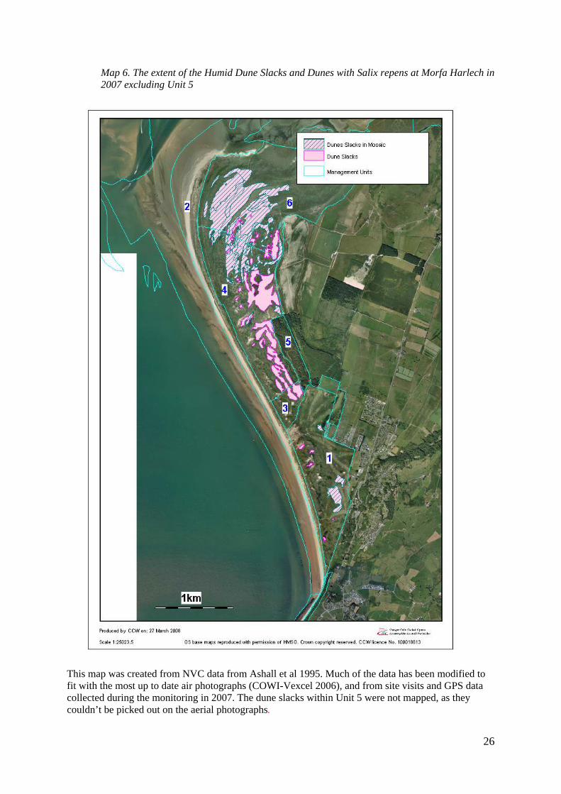
Map 6. The extent of the Humid Dune Slacks and Dunes with Salix repens at Morfa Harlech in 2007 excluding Unit 5
This map was created from NVC data from Ashall et al 1995. Much of the data has been modified to fit with the most up to date air photographs (COWI-Vexcel 2006), and from site visits and GPS data collected during the monitoring in 2007. The dune slacks within Unit 5 were not mapped, as they couldn’t be picked out on the aerial photographs.
27
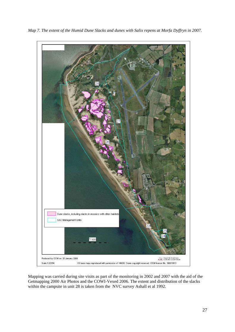
Map 7. The extent of the Humid Dune Slacks and dunes with Salix repens at Morfa Dyffryn in 2007.
Mapping was carried during site visits as part of the monitoring in 2002 and 2007 with the aid of the Getmapping 2000 Air Photos and the COWI-Vexed 2006. The extent and distribution of the slacks within the campsite in unit 28 is taken from the NVC survey Ashall et al 1992.
28
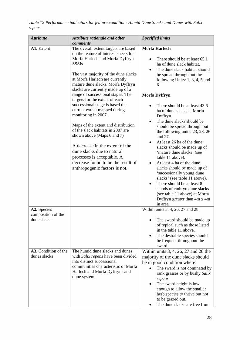
Table 12 Performance indicators for feature condition: Humid Dune Slacks and Dunes with Salix repens Attribute Attribute rationale and other
comments Specified limits
A1. Extent The overall extent targets are based on the feature of interest sheets for Morfa Harlech and Morfa Dyffryn SSSIs. The vast majority of the dune slacks at Morfa Harlech are currently mature dune slacks. Morfa Dyffryn slacks are currently made up of a range of successional stages. The targets for the extent of each successional stage is based the current extent mapped during monitoring in 2007. Maps of the extent and distribution of the slack habitats in 2007 are shown above (Maps 6 and 7) A decrease in the extent of the dune slacks due to natural processes is acceptable. A decrease found to be the result of anthropogenic factors is not.
Morfa Harlech
• There should be at least 65.1 ha of dune slack habitat.
• The dune slack habitat should be spread through out the following Units: 1, 3, 4, 5 and 6.
Morfa Dyffryn
• There should be at least 43.6 ha of dune slacks at Morfa Dyffryn
• The dune slacks should be should be spread through out the following units: 23, 28, 26 and 27.
• At least 26 ha of the dune slacks should be made up of ‘mature dune slacks’ (see table 11 above).
• At least 4 ha of the dune slacks should be made up of ‘succesionally young dune slacks’ (see table 11 above).
• There should be at least 8 stands of embryo dune slacks (see table 11 above) at Morfa Dyffryn greater than 4m x 4m in area.
A2. Species composition of the dune slacks.
Within units 3, 4, 26, 27 and 28:
• The sward should be made up of typical such as those listed in the table 11 above.
• The desirable species should be frequent throughout the sward.
A3. Condition of the dunes slacks
The humid dune slacks and dunes with Salix repens have been divided into distinct successional communities characteristic of Morfa Harlech and Morfa Dyffryn sand dune system.
Within units 3, 4, 26, 27 and 28 the majority of the dune slacks should be in good condition where:
• The sward is not dominated by rank grasses or by bushy Salix repens.
• The sward height is low enough to allow the smaller herb species to thrive but not to be grazed out.
• The dune slacks are free from
29
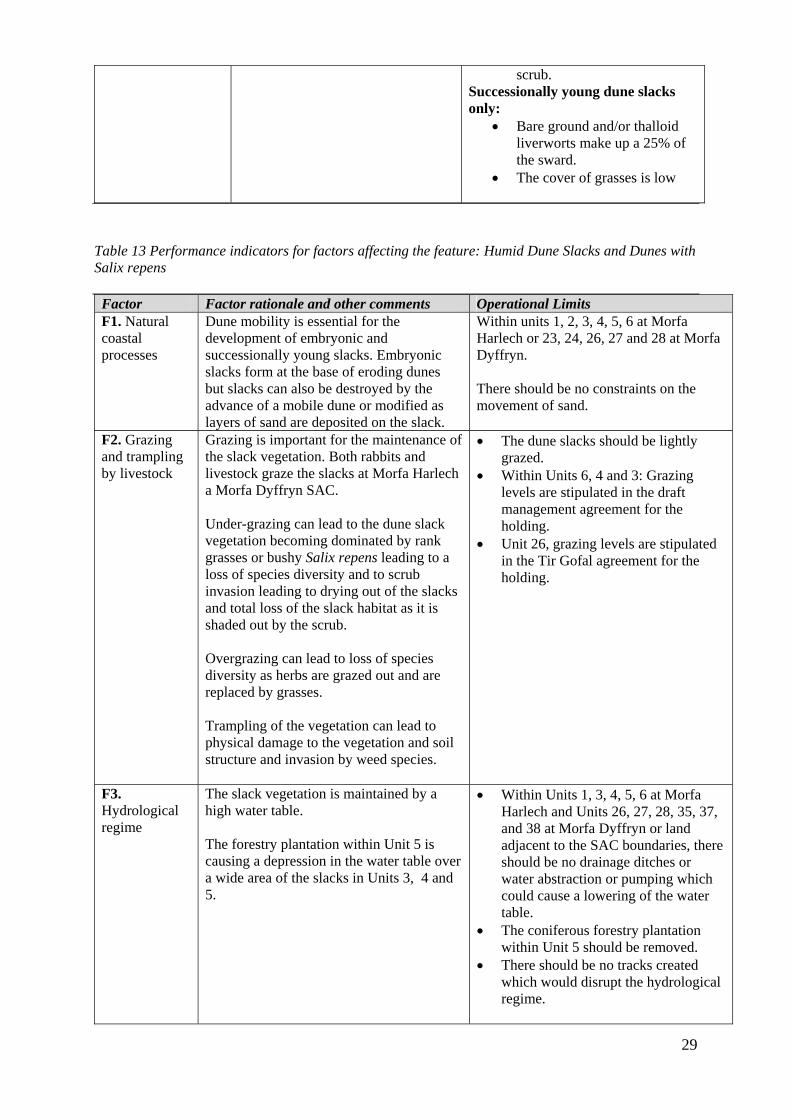
scrub. Successionally young dune slacks only:
• Bare ground and/or thalloid liverworts make up a 25% of the sward.
• The cover of grasses is low
Table 13 Performance indicators for factors affecting the feature: Humid Dune Slacks and Dunes with Salix repens Factor Factor rationale and other comments Operational Limits F1. Natural coastal processes
Dune mobility is essential for the development of embryonic and successionally young slacks. Embryonic slacks form at the base of eroding dunes but slacks can also be destroyed by the advance of a mobile dune or modified as layers of sand are deposited on the slack.
Within units 1, 2, 3, 4, 5, 6 at Morfa Harlech or 23, 24, 26, 27 and 28 at Morfa Dyffryn. There should be no constraints on the movement of sand.
F2. Grazing and trampling by livestock
Grazing is important for the maintenance of the slack vegetation. Both rabbits and livestock graze the slacks at Morfa Harlech a Morfa Dyffryn SAC. Under-grazing can lead to the dune slack vegetation becoming dominated by rank grasses or bushy Salix repens leading to a loss of species diversity and to scrub invasion leading to drying out of the slacks and total loss of the slack habitat as it is shaded out by the scrub. Overgrazing can lead to loss of species diversity as herbs are grazed out and are replaced by grasses. Trampling of the vegetation can lead to physical damage to the vegetation and soil structure and invasion by weed species.
• The dune slacks should be lightly grazed.
• Within Units 6, 4 and 3: Grazing levels are stipulated in the draft management agreement for the holding.
• Unit 26, grazing levels are stipulated in the Tir Gofal agreement for the holding.
F3. Hydrological regime
The slack vegetation is maintained by a high water table. The forestry plantation within Unit 5 is causing a depression in the water table over a wide area of the slacks in Units 3, 4 and 5.
• Within Units 1, 3, 4, 5, 6 at Morfa Harlech and Units 26, 27, 28, 35, 37, and 38 at Morfa Dyffryn or land adjacent to the SAC boundaries, there should be no drainage ditches or water abstraction or pumping which could cause a lowering of the water table.
• The coniferous forestry plantation within Unit 5 should be removed.
• There should be no tracks created which would disrupt the hydrological regime.

30
F4. Vehicle or visitor damage
Vehicles or pressure from visitors including camping can cause damage or loss of to slack vegetation, compaction and erosion. Camping is a particular problem at Morfa Dyffryn.
• Vehicle or visitor damage should be absent or rare at vulnerable locations
• No camping or car parking should occur on the dune slack vegetation.
• There should be no new tracks, hard standing or car parking areas created within the dunes slacks.
F5. Scrub There are on going programmes of scrub
clearance within the dune slacks. Mowing has also taken place at Morfa Harlech. The removal of scrub helps prevents the loss of slack habitats to scrub and woodland. Within the forestry plantation (Unit 5) trees and scrub need to be removed from the slack habitat
Within Units 6, 5, 4, 3, 26, 27and 28 • There should be no stands of scrub
within the current area of dune slacks shown on Maps 6 and 7 above, greater than 1m x 1m.
31
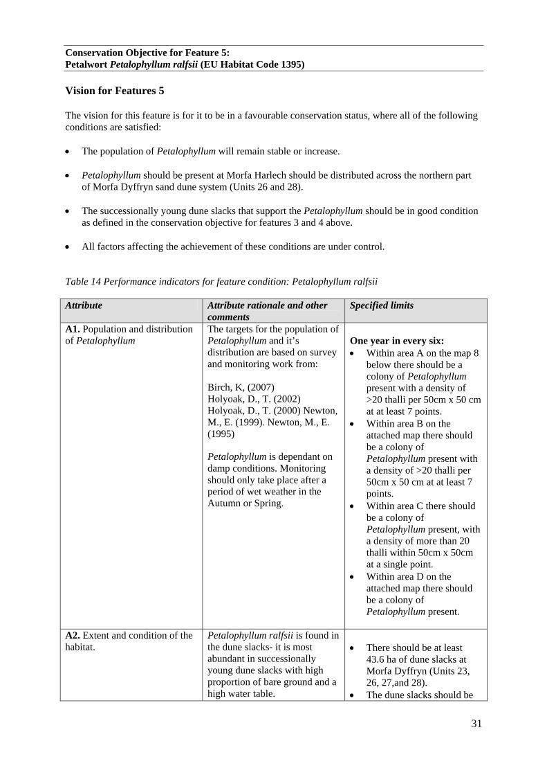
Conservation Objective for Feature 5: Petalwort Petalophyllum ralfsii (EU Habitat Code 1395) Vision for Features 5 The vision for this feature is for it to be in a favourable conservation status, where all of the following conditions are satisfied: • The population of Petalophyllum will remain stable or increase. • Petalophyllum should be present at Morfa Harlech should be distributed across the northern part
of Morfa Dyffryn sand dune system (Units 26 and 28). • The successionally young dune slacks that support the Petalophyllum should be in good condition
as defined in the conservation objective for features 3 and 4 above. • All factors affecting the achievement of these conditions are under control.
Table 14 Performance indicators for feature condition: Petalophyllum ralfsii Attribute Attribute rationale and other
comments Specified limits
A1. Population and distribution of Petalophyllum
The targets for the population of Petalophyllum and it’s distribution are based on survey and monitoring work from: Birch, K, (2007) Holyoak, D., T. (2002) Holyoak, D., T. (2000) Newton, M., E. (1999). Newton, M., E. (1995)
Petalophyllum is dependant on damp conditions. Monitoring should only take place after a period of wet weather in the Autumn or Spring.
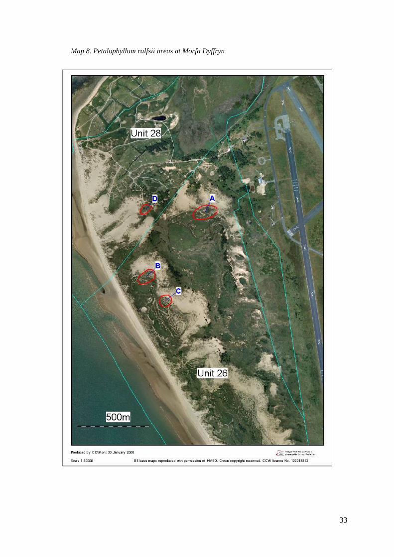
One year in every six: • Within area A on the map 8
below there should be a colony of Petalophyllum present with a density of >20 thalli per 50cm x 50 cm at at least 7 points.
• Within area B on the attached map there should be a colony of Petalophyllum present with a density of >20 thalli per 50cm x 50 cm at at least 7 points.
• Within area C there should be a colony of Petalophyllum present, with a density of more than 20 thalli within 50cm x 50cm at a single point.
• Within area D on the attached map there should be a colony of Petalophyllum present.
A2. Extent and condition of the habitat.
Petalophyllum ralfsii is found in the dune slacks- it is most abundant in successionally young dune slacks with high proportion of bare ground and a high water table.
• There should be at least
43.6 ha of dune slacks at Morfa Dyffryn (Units 23, 26, 27,and 28).
• The dune slacks should be
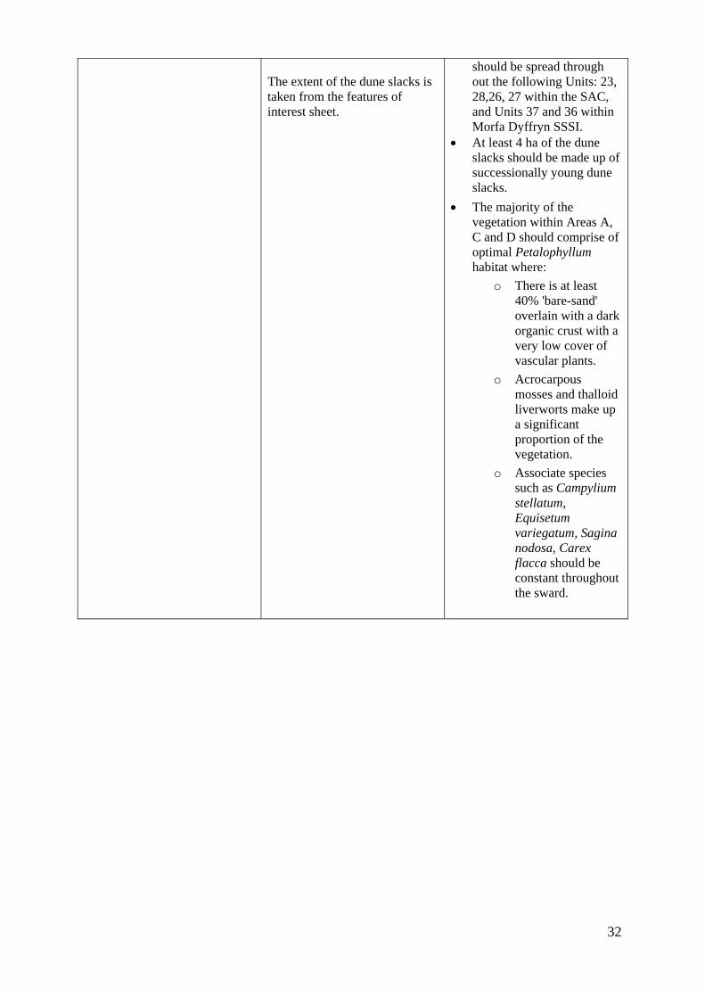
32
The extent of the dune slacks is taken from the features of interest sheet.
should be spread through out the following Units: 23, 28,26, 27 within the SAC, and Units 37 and 36 within Morfa Dyffryn SSSI.
• At least 4 ha of the dune slacks should be made up of successionally young dune slacks.
• The majority of the vegetation within Areas A, C and D should comprise of optimal Petalophyllum habitat where:
o There is at least 40% 'bare-sand' overlain with a dark organic crust with a very low cover of vascular plants.
o Acrocarpous mosses and thalloid liverworts make up a significant proportion of the vegetation.
o Associate species such as Campylium stellatum, Equisetum variegatum, Sagina nodosa, Carex flacca should be constant throughout the sward.
33
Map 8. Petalophyllum ralfsii areas at Morfa Dyffryn

34
Table 15: Performance indicators for factors affecting the feature Petalophyllum ralfsii
Factor Factor rationale and other comments
Operational Limits
F1. Vehicle or visitor damage
Physical damage by vehicles or visitors could cause the loss of Petalophyllum colonies and damage or loss of to the dune slack habitat of Petalophyllum including, compaction and erosion. 4x4 tracks originating from unit 28 were noted within Petalophyllum area A (Unit 26) in 2007.
• Vehicle or visitor damage should be absent
within areas A, B, C and D (within Units 26 and 28) on map 8.
• There should be no camping within areas A, B, C or D marked on map 8.
• No new tracks should be created.
F2. Hydrological regime
Petalophyllum favours the slacks with a high water table where seasonal flooding is common.
Within the management Units 26, 27, 28, 35, 37, and 38 or land adjacent to the SAC boundaries at Morfa Dyffryn:
• There should be no drainage ditches or water abstraction or pumping which could cause a lowering of the water table.
F3. Succession
Petalophyllum ralfsii is found primarily within early successional slack habitats. The species can be lost through natural succession to drier more closed communities; however, the natural creation of new slack habitats should create new opportunities for Petalophyllum to colonise.
No targets set.

35
5. ASSESSMENT OF CONSERVATION STATUS AND MANAGEMENT REQUIREMENTS This part of the document provides: • A summary of the assessment of the conservation status of each feature. • A summary of the management issues that need to be addressed to maintain or restore each
feature. 5.1 Conservation Status and Management Requirements of Feature 1: Embryonic Shifting Dunes (NVC SD 2, 4 & 5) Conservation Status of Feature 1 The condition of the embryonic shifting dunes was assessed as Favourable: Maintained on the basis of SAC monitoring carried out in September 2007. The SAC monitoring report for this feature has yet to be produced. The assessment is based on the extent of the feature. There were no quality attributes assessed. The target for the feature extent is: 700m of embryonic shifting dunes should be present along the beach front at Morfa Harlech (Unit 2) of which there should be 50m south of the main beach access point. In September 2007 there were at least 3790 m of embryonic shifting dunes with more than 1 km present south of the main beach access point. Some of the strand line vegetation had been damaged by grazing to the far north of Morfa Harlech in Unit 2. This was because of stock accessing the beach, as they have been doing for generations, from the adjacent Unit 6. This is the first year that damage to the strandline of this nature, has been recorded. Management Requirements of Embryonic Shifting Dunes Direct management of this feature is minimal since factors which affect this feature are largely driven by natural processes. Sediment supply This feature relies on a continuous supply of fresh blown sand from both on and off site. Existing coastal defence works will already be affecting the feature. This supply of fresh blown sand needs to be maintained. On site, this supply of sand can be protected by not carrying out dune stabilisation works, the supply of sand from off site sources can only be protected by assessing and influencing decisions regarding off site developments which could affect the sediment supply, such as coastal defence works.
• Any proposed new dune stabilisation works or coastal defence works within the coastal cell (between the Mawddach Estuary and Morfa Bychan) which may affect the sand supply should be subject to Environmental Impact Assessments in order to establish whether they will have an effect on the sediment supply and thus the SAC features.
• Monitoring of accretion and erosion on the beachfronts at Morfa Harlech and Morfa Dyffryn needs to continue. If the targets for accretion rates are not met then investigations needs to be carried out into the cause of the problem. If a decline in the accretion rates is recorded and the cause is found to be human activities then the problem will need to be addressed.
Mechanical beach cleaning Organic matter deposited on the beach by high tides is essential for the creation of new embryonic dunes.
36
• A presumption against beach cleaning, where organic matter is removed, should continue.
Visitor or vehicle damage Vehicles and trampling by people can cause physical damage to the embryo dunes and the vegetation of the embryo dunes and strandline.
• Unrestricted vehicle access to the beach at Morfa Harlech or Morfa Dyffryn should not be allowed and any vehicles used for routine management should not be permitted to drive on the embryonic dunes or strand line vegetation.
Grazing Strand line vegetation is not normally visibly grazed i.e. grazing may take place so long as no obvious adverse effects are noted. See above.
• Surveillance of stock grazing within Unit 6 /2 should take place to ascertain whether this was a one-off phenomenon in 2007. If adverse grazing of the strandline vegetation occurs again, when it happens and by which stock needs to be recorded. The grazier needs to be asked if he has noticed this grazing habit.
37
5.2 Conservation Status and Management Requirements of Feature 2: Shifting Dunes along the shoreline with Ammophila (NVC SD6) Conservation Status of Feature 2 The condition of the shifting dunes was assessed as Favourable: Maintained on the basis of SAC monitoring carried out in 2007. The SAC monitoring report for this feature has yet to be produced. The assessment was based on the extent of the feature. There were no quality attributes assessed. The target for the feature extent was: there should be at least 18.9 ha of shifting dunes at Morfa Harlech, of which more than 4 ha should be inland from the beach front including at least two areas of shifting dunes greater than 0.4 ha in extent. The extent of the dunes should also comprise at least 5000m of shifting dunes along the beachfront. An assessment based on the 2006 aerial photographs, backed up by site visits found that the targets for the extent of the dune vegetation were met. Management Requirements of Feature 2 Direct management of this feature is minimal since factors that affect this feature are largely driven by natural processes. Sediment supply See ‘Sediment supply’ within the Management requirements for Feature 1 above. Organic matter deposited on the beach by high tides is essential for the creation of new embryo dunes which go on to form shifting dunes. Natural Coastal Processes Management should be aimed at minimising any constraints to the natural movement of sand. This should allow the dunes to form, move and erode as naturally as possible.
• Dune stabilisation works should only be considered where severe erosion has been caused by vehicle or visitor pressure.
Grazing Although grazing levels are seldom set to include shifting dune communities, where shifting dunes are open to adjacent grazed grasslands and slacks, stock will graze the more palatable, stabilising grasses such as Festuca rubra on the shifting dunes.
• Where possible, livestock should have access to shifting dunes. Vehicle or visitor damage Vehicles and visitor pressure can cause damage to the vegetation communities and physical damage to the dunes leading to erosion and in some cases large-scale blowouts. However, some disturbance by visitor access on foot can be beneficial because it can help keep the shifting dunes mobile. Restrictions to visitor access on foot should only be in place where access is causing or has caused large-scale erosion or blowouts. These restrictions should be reviewed once damaged areas have been restored.
• Vehicle restrictions to the beach and dunes need to continue.
• Access to the dunes should be restricted to fenced paths at the following locations; main beach access route from Glan Y Mor Car Park through Unit 1, Morfa Harlech and the main access route from Dyffryn Seaside Estate which cuts through Unit 26.

38
• Erosion within Unit 28 (Mochras/ Shell Island) needs to be reviewed and consideration needs
to be given to restricting access to the dunes to pathways or board walks.
Forestry Plantation
• The forestry plantation which has stabilised the shifting dunes at Morfa Harlech within Unit 5 should be removed.
Scrub There is some localized encroachment of scrub onto the mobile dunes, fro example within units 1, 3 and 4.
• The ongoing programme of scrub control should be continued and expanded. Invasive species
• The Clematis vitalba should be cleared from the shifting dunes within Unit 1.
39
5.3 Conservation Status and Management Requirements of Features 3 and 4: Humid Dune Slacks and Dunes with Salix repens (NVC SD 13, 14, 15, 16, 17) Conservation Status of Features 3 and 4 The condition of the humid dune slacks and dunes with Salix repens was provisionally assessed as Unfavourable: Declining on the basis of SAC monitoring carried out in 2007. The SAC monitoring report for this feature has yet to be produced. The assessment for the extent of the features was based on aerial photograph analysis (COWI 2006) and on site mapping. The assessment for the quality of the dunes slack habitats was based on monitoring plot data. Five monitoring plots were placed at Morfa Dyffryn within Unit 26 where humid dune slacks and dunes with Salix repens are the key habitats. The plots were placed in key stands of mature and successionally young dune slack vegetation. Systematic sample points were assessed within each plot against the attributes listed in the performance indicator; although the sample targets for monitoring were more rigidly defined. The dune slack vegetation within Unit 26 was found to be in good condition and should be classed as Favourable: Recovered. Humid dune slacks and dunes with Salix repens are also the key habitats within Unit 28 (Mochras/ Shell Island). Unfortunately, access permission was not granted for this part of the site for monitoring in 2007. We are aware that camping continues to occur in this area. This means that the infrastructure and associated activities are also continuing to affect SAC features in ways previously recorded. Site visits by the district team have found that the major slack has a track forming a ‘causeway’ across it thereby impeding natural drainage. The central area has significant scrub encroachment and the edge areas are mown occasionally which has produced amenity type grassland vegetation with frequent white clover. The dune slacks within Unit 28 are therefore considered to be Unfavourable: Declining. Four monitoring plots were assessed at Morfa Harlech within Units 4 and 3 where humid dune slacks and dunes with Salix repens are the key habitats. All of these were in stands of mature dune slack vegetation. Although the plot data has yet to be analysed few points appeared to pass during the data collection and the majority of the slack vegetation appeared to be unfavourable in the field, mainly on the basis of the presence of scrub, but also because of over grazing by cattle. This ‘overgrazing’ results in cattle trampled routes and sward enrichment including the replacement of a diversity of typical plants with, for example, Agrostis stolonifera dominance. These unfavourable areas were located especially the ‘poor fen’ type of slack to the south of Unit 4 adjacent to the plantation (Unit 5, Pant Glas) and Unit 3. A contributing factor is undoubtedly the fact that these areas have only recently been cleared of invading scrub and management to control the regrowth is in progress. There are also pockets of overgrazing to the north although most of the drier dune slack is still botanically diverse. Humid dune slacks and dunes with Salix repens should be classed as favourable for both sand dune systems for these features to be reported as favourable on a whole site basis for Morfa Harlech a Morfa Dyffryn SAC. As Unit 28 of Morfa Dyffryn and parts of the Morfa Harlech dune slacks are in unfavourable condition and the factors are not under control, the favourable conservation status assessment for the SAC is Unfavourable: Declining. Management Requirements of Features 3 and 4: Dune slacks Natural coastal processes Management should be aimed at minimising any constraints to the natural movement of sand. This should allow the continued process of slack formation, maintaining a presence of embryo and successionally young slacks on site.
40
• People and vehicle access should be managed so that it does not adversely affect the dune slack SAC features. Dune stabilisation works should only be considered in exceptional cases where severe erosion has been caused by vehicle or visitor pressure. The first action should be to manage the source of the problem.
Grazing Humid dune slacks and dunes with Salix repens are maintained by the seasonally high water table, grazing and scrub control. Grazing by domestic stock facilitates rabbit grazing since rabbits tend to graze where the sward is already short. Grazing levels should be set to allow the maintenance of a low, species rich sward throughout the majority of the dune slacks and to reduce the spread of scrub.
• The dune slacks should be grazed lightly, preferably by cattle, in summer. Grazing by cattle in winter is acceptable provided supplementary feeding and poaching do not take place. Winter sheep grazing is generally benign provided there is no supplementary feeding; however, sheep do not graze coarser vegetation, which gives it a competitive advantage.
• Grazing at Morfa Dyffryn should continue at present levels in the TG agreement, but use of
mineral licks should be considered to encourage the cattle to graze more distant slacks. Scrub Scrub clearance is necessary at both Morfa Harlech and Morfa Dyffryn since scrub encroachment has been considerable over the last 30 years and grazing alone cannot keep scrub in check. Where natural processes such as mobility, erosion, wind scour and flooding, are highly significant, scrub invasion is not an issue. Where slacks are more mature scrub can become a problem especially when grazing ceases or is reduced for a period and early scrub encroachment is not controlled. As scrub becomes established shelter and seeding increases and the problem is then exacerbated as stock cannot gain easy access to graze. The forestry plantation on the dune system at Morfa Harlech is a major contributing factor in the spread of scrub onto the adjacent dune slack.
• The scrub clearance programmes at Morfa Harlech and Morfa Dyffryn need to continue.
Mowing Mowing has taken place within dune slacks at Morfa Harlech as an occasional activity to facilitate the spread of grazing and to some extent to control dense low willow scrub growth and regrowth following initial clearance management. Mowing has achieved good results by reducing the competitive advantage of coarse and woody growth thereby favouring desirable species such as marsh helleborine Epipactis palustris.
• Mowing may continue only as consented.
Hydrological regime The dune slack communities are dependent on a high water table, particularly in the winter. The depth of the water table and degree of inundation throughout the winter months affects the type and composition of dune slack communities. The Pant Glas forestry plantation within Unit 5 is causing a depression of the water table within the adjacent Units (4 and 3). Ditches within the vicinity of the dune slack habitats at the golf course (Unit 1), Glan y Mor (Unit 3, 4, 2 and 6) could also have a detrimental effect on the water table. Off site, larger drainage ditches could also be lowering the level of the water table. The airfield and farmland adjacent to Morfa Dyffryn are heavily drained with a deep drainage ditch which then cuts through the dunes within Unit 26. This ditch is maintained by the Environment Agency. Management should aim to protect and restore the naturally high water table of the dune slacks.
41
At the golf course (Unit 1) water is pumped from the course when the water table reaches an agreed level. This is a consented activity.
• The forestry plantation within Unit 5 should be removed. • The presumption against new ditching within units containing dune slack habitats or adjacent
units should be continued (Units 1, 3, 4, 6, 26, 28, 27 and 23). • The findings of the research currently being carried out on the effects of existing on site
ditches and into drainage systems on adjacent land need to be considered and assigned agreed action points.
• Onsite monitoring of dip wells needs to be reviewed and continued at appropriate intervals. If useful data is produced and more is needed then monitoring should be continued for a defined time period.
• An investigation needs to be carried out into the effects of pumping water from the golf course.
Recreation Camping, vehicle and visitor access causes damage to the vegetation communities and physical damage to the dune slacks.
• Vehicle restrictions to the dunes need to continue and be reviewed as problems arise. • Fencing and board walks need to be maintained at the access points from the Glan Y Mor car
park, Morfa Harlech and from the Dyffryn Seaside Estate, Morfa Dyffryn. Good access to the beach, the main destination, discourages deviation onto the dune slack habitat.
• There should be no further camping within dune slack habitat within Unit 28, Shell Island/ Mochras and the associated infrastructure, activities and currently uncontrolled vehicular access need to be managed. The dune car park should be re-sited.
42
5.4 Conservation Status and Management Requirements of Feature 5: Petalophyllum ralfsii Conservation Status of Feature 5 The conservation status of Petalophyllum ralfsii is assessed as Favourable: Un-classified based on the monitoring report (2007) and consideration of the factors affecting the populations. A SAC monitoring report has been produced: Birch (2007) Morfa Harlech a Dyffryn, Petalophyllum ralfsii, SAC Monitoring Report, CCW. This report is based on survey and monitoring work carried out only within Unit 26. The SAC monitoring was carried out in 2006. Suitable habitat within Unit 26 was surveyed for Petalophyllum in October and November 2006. Sample points were placed in potential (suitable looking) locations as well as places where this species was previously recorded, and the density of Petalophyllum was recorded. Good numbers of Petalophyllum were recorded where it occurred previously in the north of the Unit 26. However, the report concluded that the conservation status Petalophyllum ralfsii was Unfavourable: Declining because of the factors considered to be having an adverse affect on the feature:
a) Uncontrolled camping within Unit 28. b) The low water table. c) The poor condition of the dune slack vegetation- taken from the 2002 SAC monitoring report.
However, the slack vegetation has been re-monitored since then and the slack vegetation at Morfa Dyffryn is now considered to be in good condition.
The factors were re-considered during the management planning process and further monitoring of the slack vegetation has taken place:
a) The main colony of Petalophyllum ralfsii within Unit 28 (Shell Island/ Mochras) is away from the main area used by camping. Therefore, although camping is considered a risk to Petalophyllum we have no evidence that it has caused the Petalophyllum to decline.
b) A depressed water table due to drainage at the air field may be responsible for the lack of Petalophyllum from suitable looking habitat to the south of Unit 26. However, the species has not ever been recorded in the south of this Unit, therefore it is not reasonable to expect Petalophyllum to be present in the south of the Unit.
c) The slack vegetation has been re-monitored in 2007 and the slack vegetation at Morfa Dyffryn is now considered to be in good condition.
The target for the population of Petalophyllum at Morfa Dyffryn is for the presence of colonies with specified densities of the liverwort within the key areas A, B and C marked on map 8 above, and for its presence within area D. No access permission was given for Unit 28 for SAC monitoring in 2006. Within Unit 28 (Shell Island/ Mochras) the distribution of Petalophyllum may have changed as the habitat where tiny marginal populations from the Martha Newton survey of 1995 have ‘matured’ to become unsuitable, however, it is unlikely that the species has disappeared completely from the key area D (outlined on map 8) which is away from the areas worst affected by camping. The targets for areas A, B and C within Unit 26 were based on the numbers of Petalophyllum recorded during the monitoring and are therefore favourable. The target for the population of Petalophyllum is for presence only at Morfa Harlech. Unfortunately no SAC monitoring was carried out at Morfa Harlech. There is the fact that there are old records for Petalophyllum at Morfa Harlech apart from the 1995 location which were not re-found by Dr Newton- probably lost because the species was originally recorded as growing within in sub-optimal habitat. New suitable habitat could, however, have been colonised to balance apparent losses. Petalophyllum is not a Key Species within any unit at Morfa Harlech, however it should benefit from the management of the dune slacks within units 4 and 6.

43
As the slack vegetation at Morfa Dyffryn is currently considered to be in good condition and Petalophyllum is vigorous in Unit 26 (where previously recorded), the condition of this species may be considered to be Favourable: Maintained. Management Requirements of Feature 5 Petalophyllum is reliant on good quality early successional dune slack vegetation and a high water table. This species also requires protection from visitor and vehicle damage. Management for the humid dune slacks and dunes with Salix repens (Features 3 and 4) will also benefit the population of Petalophyllum. See ‘Management Requirements’ for Features 3 and 4 above.
44
6. ACTION PLAN: SUMMARY This section takes the management requirements outlined in Section 5 a stage further, assessing the specific management actions required on each management Unit. This information is a summary of that held in CCW’s Actions Database for sites, and the database will be used by CCW and partner organisations to plan future work to meet the Wales Environment Strategy targets for sites. Unit Number
CCW Database Number
Unit Name
Summary of Conservation Management Issues Action needed?
01 001060 Unit 1 Clematis vitalba is becoming an increasing problem in the dunes to the south of the main beach access point. This invasive species needs to be controlled. Water is being pumped from the golf course to maintain drier conditions. The pumps are only activated when the water level hits a specified level; however, there are concerns over the level of the water table and the Environment Agency are due to investigate this issue.
Yes
02 001061 Unit 2 Existing coastal defence works will already be affecting the sediment supply to the site. Any new coastal defence works could also affect the sand supply. Inappropriate stabilisation works could cause the fossilisation of the mobile dunes and affect the sand to other parts of the coast. However, it is accepted that dune stabilisation work may need to be carried out in some cases where there is severe erosion caused by people or vehicles. In 2007 it was noted that the strand line was being heavily grazed at the northern end of the beach. An investigation is needed to see whether the grazing is causing damage to the vegetation community.
Yes
03 001062 Unit 3 The dune slack area would benefit from scrub cutting or mowing. Grazing levels need to be reviewed.
Yes
04 001063 Unit 4 The dune slacks and some of the lower mobile dunes would benefit from scrub cutting. The grazing levels need to be reviewed. Inappropriate mowing has been carried out within this unit in the past. Any proposed mowing needs to be agreed and consented by CCW.
Yes
45
Unit Number
CCW Database Number
Unit Name
Summary of Conservation Management Issues Action needed?
05 001064 Unit 5 The forestry plantation within unit 5 covers mobile dunes and dune slack habitat. The trees have fossilised the mobile dunes and the scrub within unit 5 is providing a seed source for scrub seeding into adjacent units (3 and 4). The trees are also likely to be causing a decrease in the water table both in unit 5 and within the adjacent units 1, 4, and 3, which could affect the dune slack vegetation.
Yes
06 001065 Unit 6 Grazing levels need to be reviewed. Stock from this unit is also moving onto the beach and grazing strand line vegetation. Inappropriate mowing is sometimes carried out within this unit.
Yes
23 001082 Unit 23 Currently this unit requires no immediate actions. It is subject to high levels of access, which have caused problems in the past. These problems were rectified by controlling access with fencing which has no been removed in parts. Because of the high levels of access problems such as accelerated erosion could arise within this unit in the future.
No
26 001085 Unit 26 This management unit is currently in good condition. The area is grazed by cattle and is within a Tir Gofal Agreement. This unit is a NNR. There is an ongoing programme of scrub clearance at Morfa Dyffryn, which needs to continue. This was previously carried out by CCW; however, the management will be the responsibility of SNP from April 2008.
Yes
27 001086 Unit 27 This unit is within a Tir Gofal management agreement area.
No
28 001087 Unit 28 The dunes within unit 28 are suffering from accelerated erosion from pressure from vehicle access to the beach and recently the NNR (Unit 26) and in some parts the dunes and dune slacks are being modified by camping activities and destroyed or damaged by the creation of tracks and hard-standings.
Yes
46
7. GLOSSARY This glossary defines the some of the terms used in this Core Management Plan. Some of the definitions are based on definitions contained in other documents, including legislation and other publications of CCW and the UK nature conservation agencies. None of these definitions is legally definitive. Action A recognisable and individually described act, undertaking or project of any kind,
specified in section 6 of a Core Management Plan or Management Plan, as being required for the conservation management of a site.
Attribute A quantifiable and monitorable characteristic of a feature that, in combination with
other such attributes, describes its condition. Common Standards Monitoring A set of principles developed jointly by the UK conservation
agencies to help ensure a consistent approach to monitoring and reporting on the features of sites designated for nature conservation, supported by guidance on identification of attributes and monitoring methodologies.
Condition A description of the state of a feature in terms of qualities or attributes that are
relevant in a nature conservation context. For example the condition of a habitat usually includes its extent and species composition and might also include aspects of its ecological functioning, spatial distribution and so on. The condition of a species population usually includes its total size and might also include its age structure, productivity, relationship to other populations and spatial distribution. Aspects of the habitat(s) on which a species population depends may also be considered as attributes of its condition.
Condition assessment The process of characterising the condition of a feature with
particular reference to whether the aspirations for its condition, as expressed in its conservation objective, are being met.
Condition categories The condition of feature can be categorised, following condition
assessment as one of the following2: Favourable: maintained; Favourable: recovered;
Favourable: un-classified Unfavourable: recovering; Unfavourable: no change; Unfavourable: declining; Unfavourable: un-classified Partially destroyed; Destroyed. Conservation management Acts or undertaking of all kinds, including but not necessarily limited
to actions, taken with the aim of achieving the conservation
2 See JNCC guidance on Common Standards Monitoring http://www.jncc.gov.uk/page-2272
47
objectives of a site. Conservation management includes the taking of statutory and non-statutory measures, it can include the acts of any party and it may take place outside site boundaries as well as within sites. Conservation management may also be embedded within other frameworks for land/sea management carried out for purposes other than achieving the conservation objectives.
Conservation objective The expression of the desired conservation status of a feature,
expressed as a vision for the feature and a series of performance indicators. The conservation objective for a feature is thus a composite statement, and each feature has one conservation objective.
Conservation status A description of the state of a feature that comprises both its condition and
the state of the factors affecting or likely to affect it. Conservation status is thus a characterisation of both the current state of a feature and its future prospects.
Conservation status assessment The process of characterising the conservation status of a
feature with particular reference to whether the aspirations for it, as expressed in its conservation objective, are being met. The results of conservation status assessment can be summarised either as ‘favourable’ (i.e. conservation objectives are met) or unfavourable (i.e. conservation objectives are not met). However the value of conservation status assessment in terms of supporting decisions about conservation management, lies mainly in the details of the assessment of feature condition, factors and trend information derived from comparisons between current and previous conservation status assessments and condition assessments.
Core Management Plan A CCW document containing the conservation objectives for a site
and a summary of other information contained in a full site Management Plan.
Factor Anything that has influenced, is influencing or may influence the condition of a
feature. Factors can be natural processes, human activities or effects arising from natural process or human activities, They can be positive or negative in terms of their influence on features, and they can arise within a site or from outside the site. Physical, socio-economic or legal constraints on conservation management can also be considered as factors.
Favourable condition See condition and condition assessment Favourable conservation status See conservation status and conservation status
assessment.3 Feature The species population, habitat type or other entity for which a site is
designated. The ecological or geological interest which justifies the designation of a site and which is the focus of conservation management.
Integrity See site integrity 3 A full definition of favourable conservation status is given in Section 4.
48
Key Feature The habitat or species population within a management Unit that is the primary
focus of conservation management and monitoring in that Unit. Management Plan The full expression of a designated site’s legal status, vision, features,
conservation objectives, performance indicators and management requirements. A complete management plan may not reside in a single document, but may be contained in a number of documents (including in particular the Core Management Plan) and sets of electronically stored information.
Management Unit An area within a site, defined according to one or more of a range of criteria,
such as topography, location of features, tenure, patterns of land/sea use. The key characteristic of management Units is to reflect the spatial scale at which conservation management and monitoring can be most effectively organised. They are used as the primary basis for differentiating priorities for conservation management and monitoring in different parts of a site, and for facilitating communication with those responsible for management of different parts of a site.
Monitoring An intermittent (regular or irregular) series of observations in time, carried out to
show the extent of compliance with a formulated standard or degree of deviation from an expected norm. In Common Standards Monitoring, the formulated standard is the quantified expression of favourable condition based on attributes.
Operational limits The levels or values within which a factor is considered to be acceptable in
terms of its influence on a feature. A factor may have both upper and lower operational limits, or only an upper limit or lower limit. For some factors an upper limit may be zero.
Performance indicators The attributes and their associated specified limits, together with
factors and their associated operational limits, which provide the standard against which information from monitoring and other sources is used to determine the degree to which the conservation objectives for a feature are being met. Performance indicators are part of, not the same as, conservation objectives. See also vision for the feature.
Plan or project Project: Any form of construction work, installation, development or other
intervention in the environment, the carrying out or continuance of which is subject to a decision by any public body or statutory undertaker. Plan: a document prepared or adopted by a public body or statutory undertaker, intended to influence decisions on the carrying out of projects. Decisions on plans and projects which affect Natura 2000 and Ramsar sites are subject to specific legal and policy procedures.
Site integrity The coherence of a site’s ecological structure and function, across its whole area, that
enables it to sustain the habitat, complex of habitats and/or the levels of populations of the species for which it is designated.
Site Management Statement (SMS) The document containing CCW’s views about the management
of a site issued as part of the legal notification of an SSSI under section 28(4) of the Wildlife and Countryside Act 1981, as substituted.
49
Special Feature See feature. Specified limit The levels or values for an attribute which define the degree to which the
attribute can fluctuate without creating cause for concern about the condition of the feature. The range within the limits corresponds to favourable, the range outside the limits corresponds to unfavourable. Attributes may have lower specified limits, upper specified limits, or both.
Unit See management Unit. Vision for the feature The expression, within a conservation objective, of the aspirations
for the feature concerned. See also performance indicators. Vision Statement The statement conveying an impression of the whole site in the state that is
intended to be the product of its conservation management. A ‘pen portrait’ outlining the conditions that should prevail when all the conservation objectives are met. A description of the site as it would be when all the features are in favourable condition.
50
8. REFERENCES Ashall, J., Duckworth, J., Holder, C., Smart, S. (1995) Sand Dune Survey of Great Britain, Site Report No 115. Morfa Harlech, Meirionnydd, Wales. 1991. JNCC Report No. 91. JNCC, Peterborough. Ashall, J., Duckworth, J., Holder, C., Smart, S. (1992) Sand Dune Survey of Great Britain, Site Report No 115. Morfa Dyffryn, Meirionnydd, Wales. 1991. JNCC Report No. 90. JNCC, Peterborough. Birch, K. (2007) Petalophyllum SAC Monitoring Report for Morfa Dyffryn. 2006. CCW Unpublished report. Holyoak, D., T. (2002) Petalwort Petalophyllum ralfsii, report to Plantlife on work carried out in England and Wales during 2001 and 2002, Plantlife report no. 202.
Holyoak, D., T. (2000) Petalwort Petalophyllum ralfsii, report on work carried out during 1999 and summary of results of work during 1997 and 1998, Plantlife report no. 143.
Pye, K., Saye, S. (2005) The Geomorphological Response of Welsh Sand Dunes to Sea Level Rise over the next 100 years and the management implications for SAC and SSSI Sites. CCW Contract Science Report No. 670.
Lewis. H, (2002) Morfa Harlech a Morfa Dyffryn, Embryonic Shifting Dunes, Shifting Dunes along the Shoreline with Ammophila, Humid Dune Slacks and Dunes with Salix repens SAC Monitoring Report (Unpublished). CCW
Newton, M., E. (1999) Morfa Dyffryn NNR and SSSI bryophyte survey, report for Countryside Council for Wales. Newton, M., E. (1995) Survey and monitoring of Petalwort Petalophyllum ralfsii in Gwynedd and Clwyd, January 1995. Unpublished report for Countryside Council for Wales.


![RALI ADFER COEDWIGOEDD CYMRU 2020 - Harlech Motor Clubharlechdmc.co.uk/.../Regs-Rali-Adfer-Coedwigoedd-Cymru.pdf · 2020. 12. 2. · ð ^ Z } µ o v Ç } ] u v } o P ] o } v } µ](https://img.pdfslide.tips/doc/110x75/61066fb6f341a10bd566c88b/rali-adfer-coedwigoedd-cymru-2020-harlech-motor-2020-12-2-z-o-v.jpg)