Embed Size (px)
Citation preview
MINISTERIO DE AGRICULTURA, ALIMENTACIÓN Y MEDIO AMBIENTE
Javier Ruza Rodríguez
DIRECCIÓN GENERAL DEL AGUA
SUBDIRECCIÓN GENERAL DE PLANIFICACION
Y USO SOSTENIBLE DEL AGUA
Collaborative production and management of water information
How to make polycentric information available to managers, agencies and the public
SPANISH EXPERIENCE
INTERNATIONAL CONFERENCE ON DATA, INFORMATION AND KNOWLEDGE FOR WATER GOVERNANCE IN NETWORKED SOCIETIES
9‐11 June 2014, University of Seville (Spain)
2
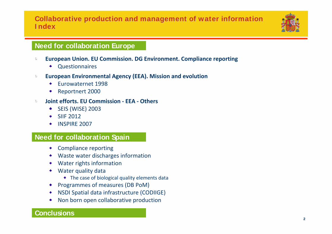
European Union. EU Commission. DG Environment. Compliance reportingQuestionnaires
European Environmental Agency (EEA). Mission and evolutionEurowaternet 1998Reportnert 2000
Joint efforts. EU Commission ‐ EEA ‐ OthersSEIS (WISE) 2003SIIF 2012INSPIRE 2007
Compliance reportingWaste water discharges informationWater rights informationWater quality data
The case of biological quality elements dataProgrammes of measures (DB PoM)NSDI Spatial data infrastructure (CODIIGE)Non born open collaborative production
Collaborative production and management of water informationCollaborative production and management of water informationIndexIndex
Need for collaboration Europe
Need for collaboration Spain
Conclusions

3
The need for collaborationEurope
4
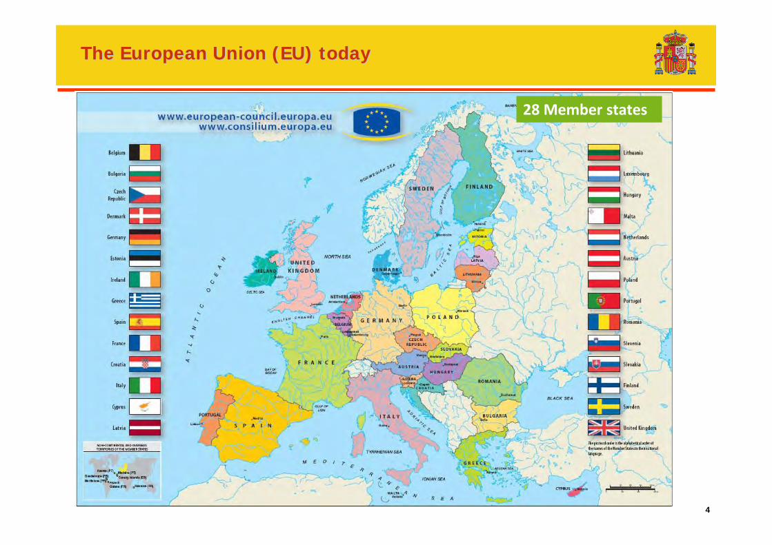
The European Union (EU) todayThe European Union (EU) today
28 Member states
5
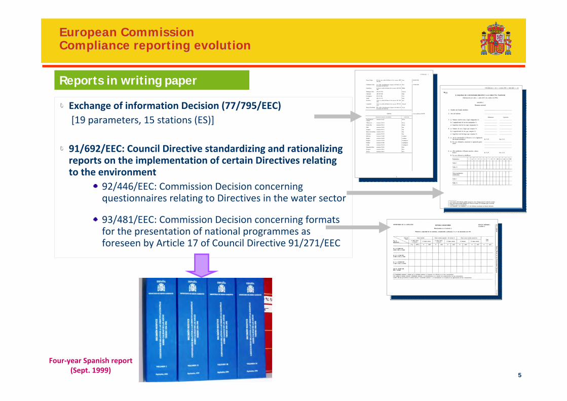
European CommissionEuropean CommissionCompliance reporting evolutionCompliance reporting evolution
Reports in writing paper
Exchange of information Decision (77/795/EEC)[19 parameters, 15 stations (ES)]
91/692/EEC: Council Directive standardizing and rationalizing reports on the implementation of certain Directives relating to the environment
92/446/EEC: Commission Decision concerning questionnaires relating to Directives in the water sector
93/481/EEC: Commission Decision concerning formats for the presentation of national programmes as foreseen by Article 17 of Council Directive 91/271/EEC
Four‐year Spanish report (Sept. 1999)
6
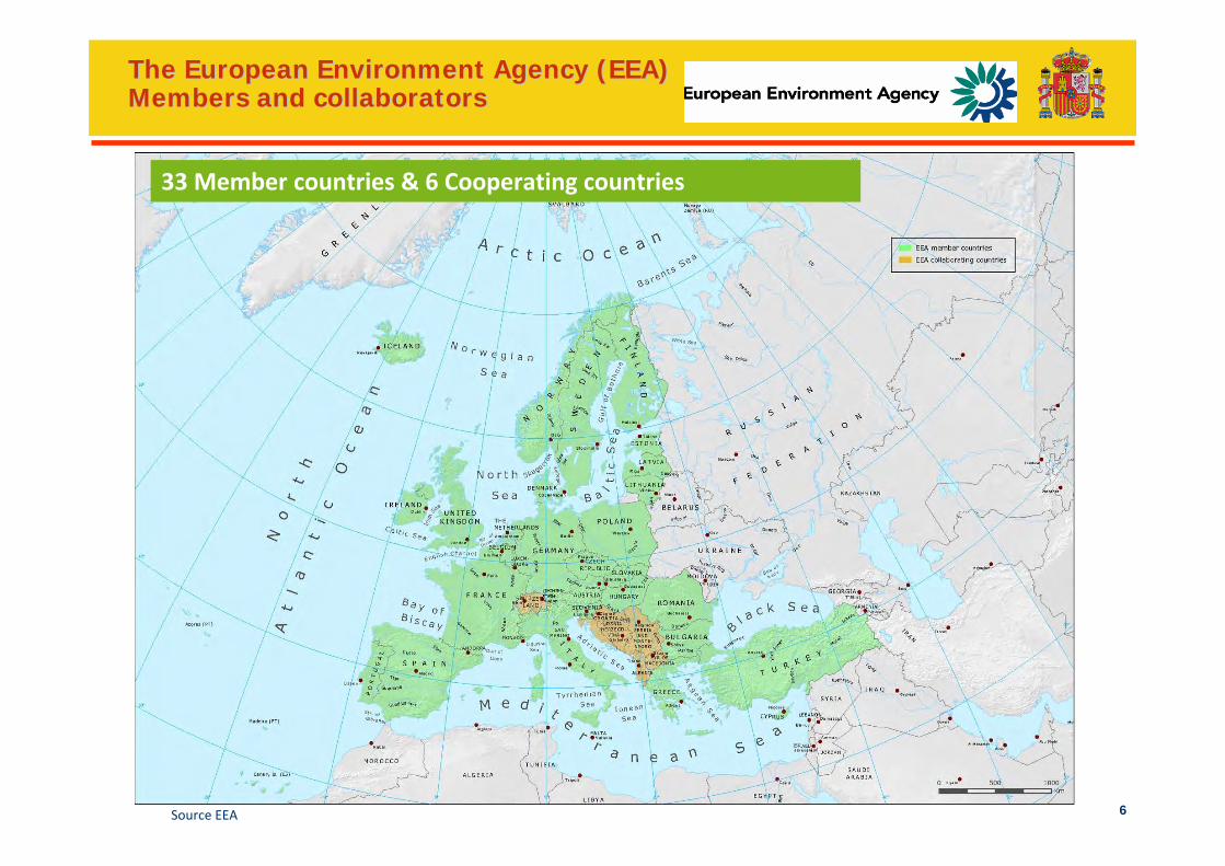
The European Environment Agency (EEA)The European Environment Agency (EEA)Members and collaboratorsMembers and collaborators
Source EEA
33 Member countries & 6 Cooperating countries
7
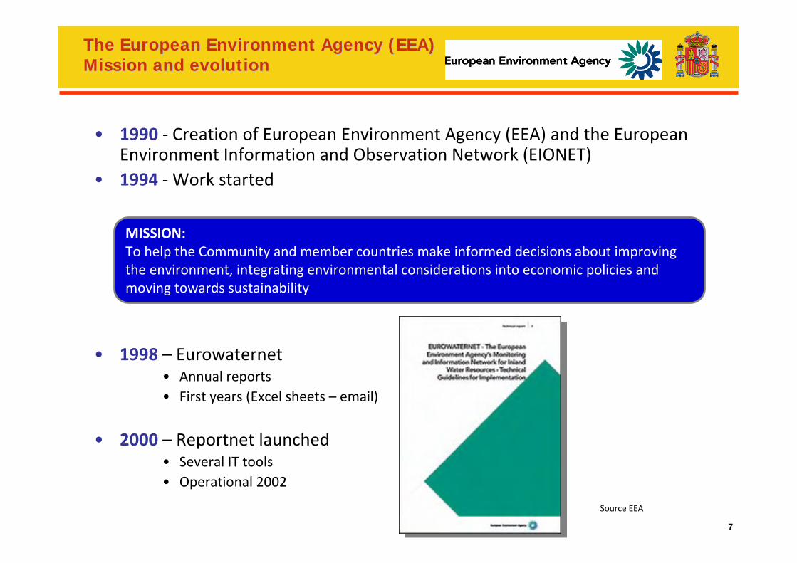
The European Environment Agency (EEA)The European Environment Agency (EEA)Mission and evolutionMission and evolution
• 1990 ‐ Creation of European Environment Agency (EEA) and the European Environment Information and Observation Network (EIONET)
• 1994 ‐Work started
• 1998 – Eurowaternet• Annual reports• First years (Excel sheets – email)
• 2000 – Reportnet launched• Several IT tools• Operational 2002
Source EEA
MISSION:To help the Community and member countries make informed decisions about improving the environment, integrating environmental considerations into economic policies and moving towards sustainability
8
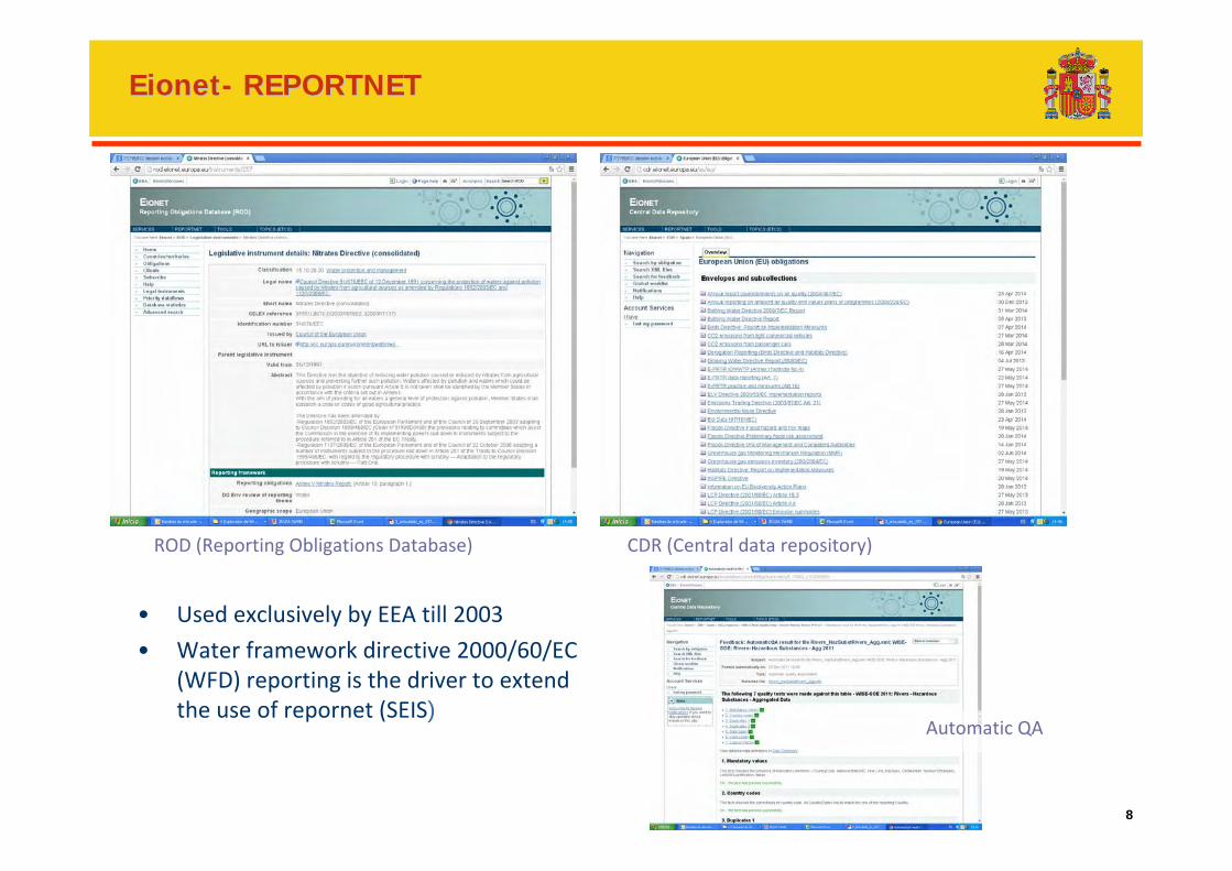
EionetEionet-- REPORTNETREPORTNET
ROD (Reporting Obligations Database) CDR (Central data repository)
Automatic QA
• Used exclusively by EEA till 2003
• Water framework directive 2000/60/EC (WFD) reporting is the driver to extend the use of repornet (SEIS)
9
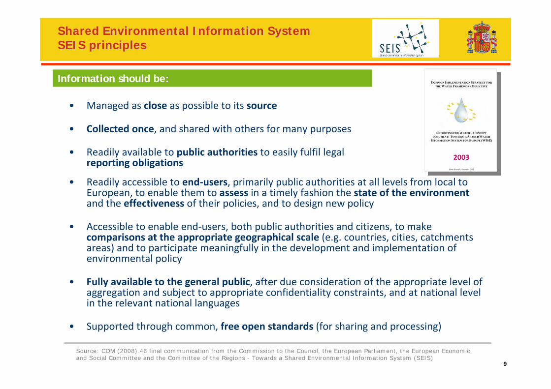
Shared Environmental Information System Shared Environmental Information System SEIS principlesSEIS principles
• Managed as close as possible to its source
• Collected once, and shared with others for many purposes
• Readily available to public authorities to easily fulfil legalreporting obligations
• Readily accessible to end‐users, primarily public authorities at all levels from local to European, to enable them to assess in a timely fashion the state of the environmentand the effectiveness of their policies, and to design new policy
• Accessible to enable end‐users, both public authorities and citizens, to make comparisons at the appropriate geographical scale (e.g. countries, cities, catchments areas) and to participate meaningfully in the development and implementation of environmental policy
• Fully available to the general public, after due consideration of the appropriate level of aggregation and subject to appropriate confidentiality constraints, and at national level in the relevant national languages
• Supported through common, free open standards (for sharing and processing)
Source: COM (2008) 46 final communication from the Commission to the Council, the European Parliament, the European Economic and Social Committee and the Committee of the Regions - Towards a Shared Environmental Information System (SEIS)
Information should be:
2003
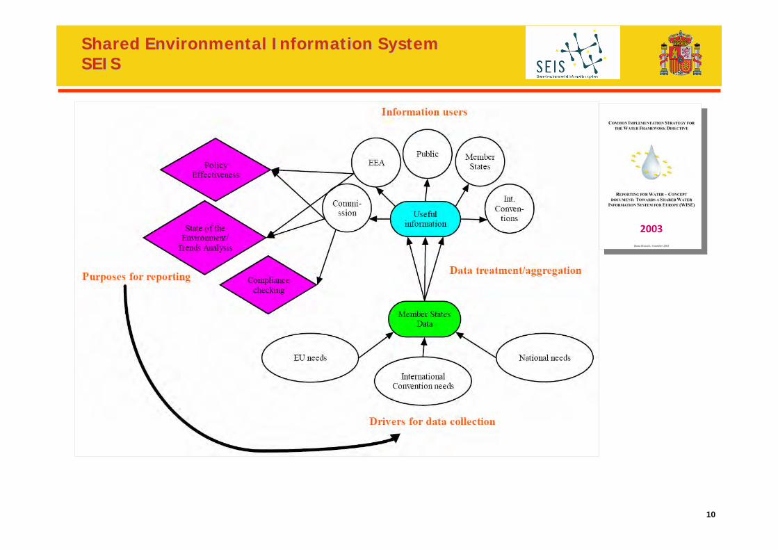
10
Shared Environmental Information System Shared Environmental Information System SEISSEIS
2003
11
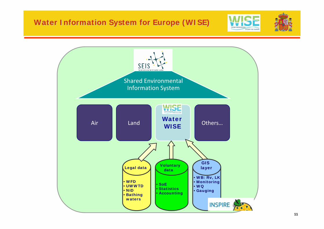
Water Information System for Europe (WISE)Water Information System for Europe (WISE)
Shared EnvironmentalInformation System
Air LandWaterWISE Others…
Legal data
•WFD•UWWTD•NiD•Bathing
waters
Voluntarydata
•SoE•Statistics•Accounting
GISlayer
•WB: Rv, LK •Monitoring•WQ•Gauging
12
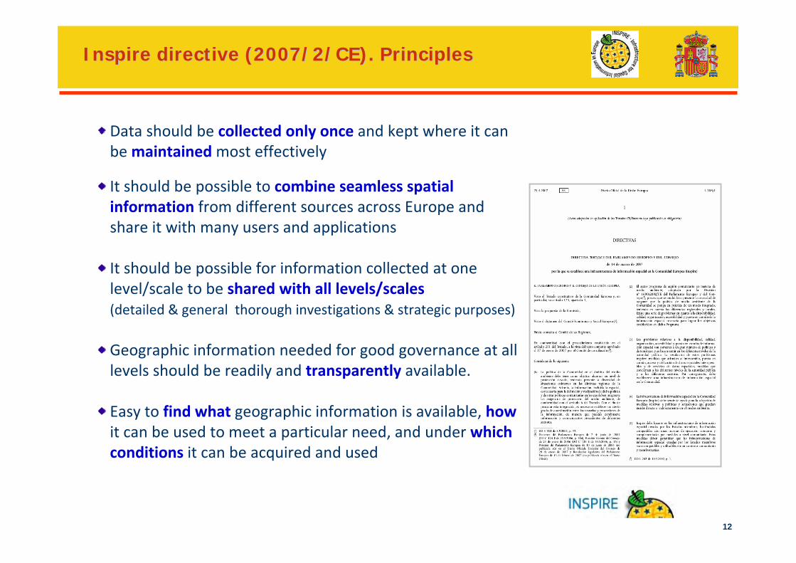
Inspire directive (2007/2/CE). PrinciplesInspire directive (2007/2/CE). Principles
Data should be collected only once and kept where it can be maintainedmost effectively
It should be possible to combine seamless spatial information from different sources across Europe and share it with many users and applications
It should be possible for information collected at one level/scale to be shared with all levels/scales (detailed & general thorough investigations & strategic purposes)
Geographic information needed for good governance at all levels should be readily and transparently available.
Easy to find what geographic information is available, howit can be used to meet a particular need, and under which conditions it can be acquired and used
13
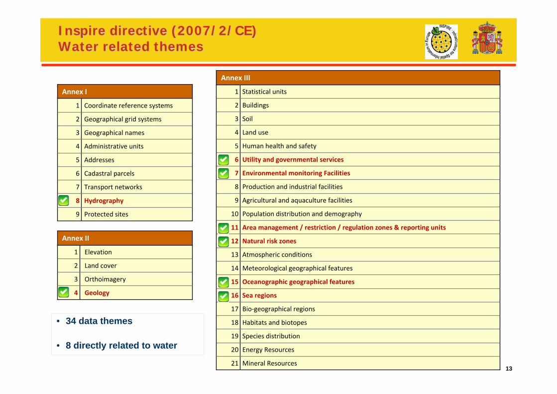
Inspire directive (2007/2/CE) Inspire directive (2007/2/CE) Water related themesWater related themes
Protected sites9
Hydrography8
Transport networks 7
Cadastral parcels6
Addresses5
Administrative units4
Geographical names 3
Geographical grid systems 2
Coordinate reference systems 1
Annex I
Geology4
Orthoimagery3
Land cover2
Elevation1
Annex II
Mineral Resources21
Energy Resources 20
Species distribution 19
Habitats and biotopes 18
Bio‐geographical regions 17
Sea regions 16
Oceanographic geographical features 15
Meteorological geographical features 14
Atmospheric conditions 13
Natural risk zones12
Area management / restriction / regulation zones & reporting units 11
Population distribution and demography 10
Agricultural and aquaculture facilities 9
Production and industrial facilities 8
Environmental monitoring Facilities7
Utility and governmental services 6
Human health and safety 5
Land use 4
Soil 3
Buildings 2
Statistical units 1
Annex III
• 34 data themes
• 8 directly related to water
14
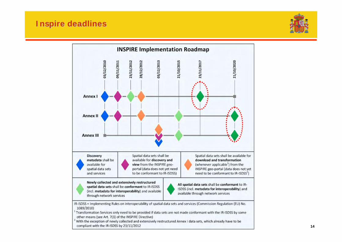
Inspire deadlinesInspire deadlines
15
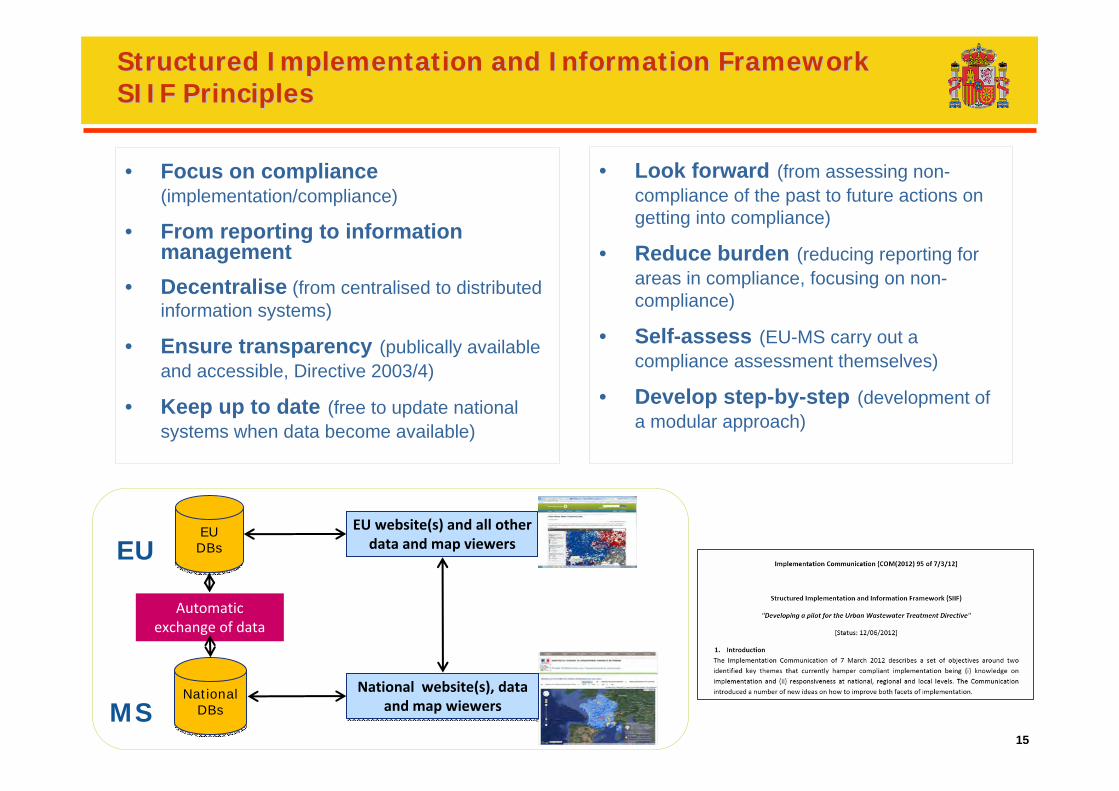
Structured Implementation and Information FrameworkStructured Implementation and Information FrameworkSIIF PrinciplesSIIF Principles
15
• Focus on compliance(implementation/compliance)
• From reporting to information management
• Decentralise (from centralised to distributed information systems)
• Ensure transparency (publically available and accessible, Directive 2003/4)
• Keep up to date (free to update national systems when data become available)
• Look forward (from assessing non-compliance of the past to future actions on getting into compliance)
• Reduce burden (reducing reporting for areas in compliance, focusing on non-compliance)
• Self-assess (EU-MS carry out a compliance assessment themselves)
• Develop step-by-step (development of a modular approach)
EU website(s) and all other data and map viewers
National website(s), data and map wiewers
National website(s), data and map wiewers
Automatic exchange of data
EU DBsEU DBs
NationalDBs
NationalDBs
EU
MS
16
The need for collaborationSpain
17
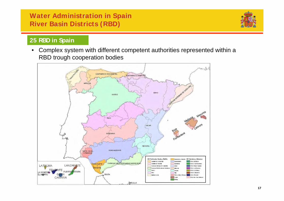
Water Administration in SpainWater Administration in SpainRiver Basin Districts (RBD)River Basin Districts (RBD)
• Complex system with different competent authorities represented within a RBD trough cooperation bodies
25 RBD in Spain
18
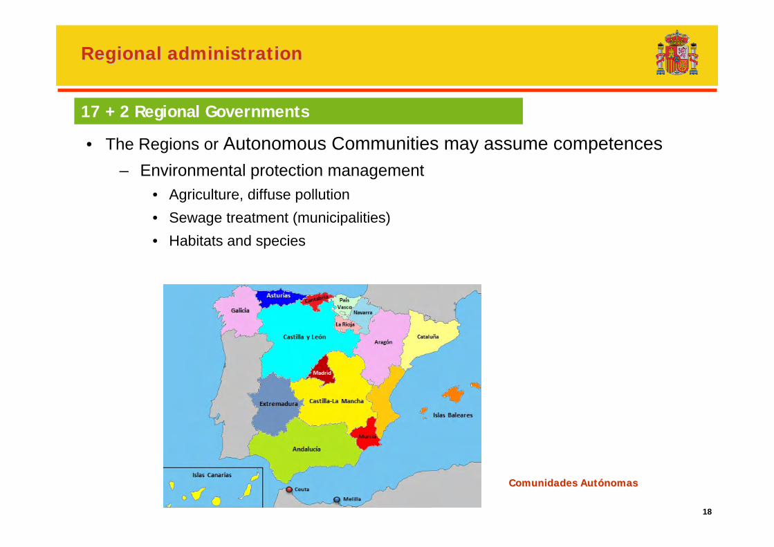
• The Regions or Autonomous Communities may assume competences– Environmental protection management
• Agriculture, diffuse pollution• Sewage treatment (municipalities)• Habitats and species
17 + 2 Regional Governments
Regional administrationRegional administration
Comunidades AutComunidades Autóónomasnomas

19
Compliance reportingin Spain
20
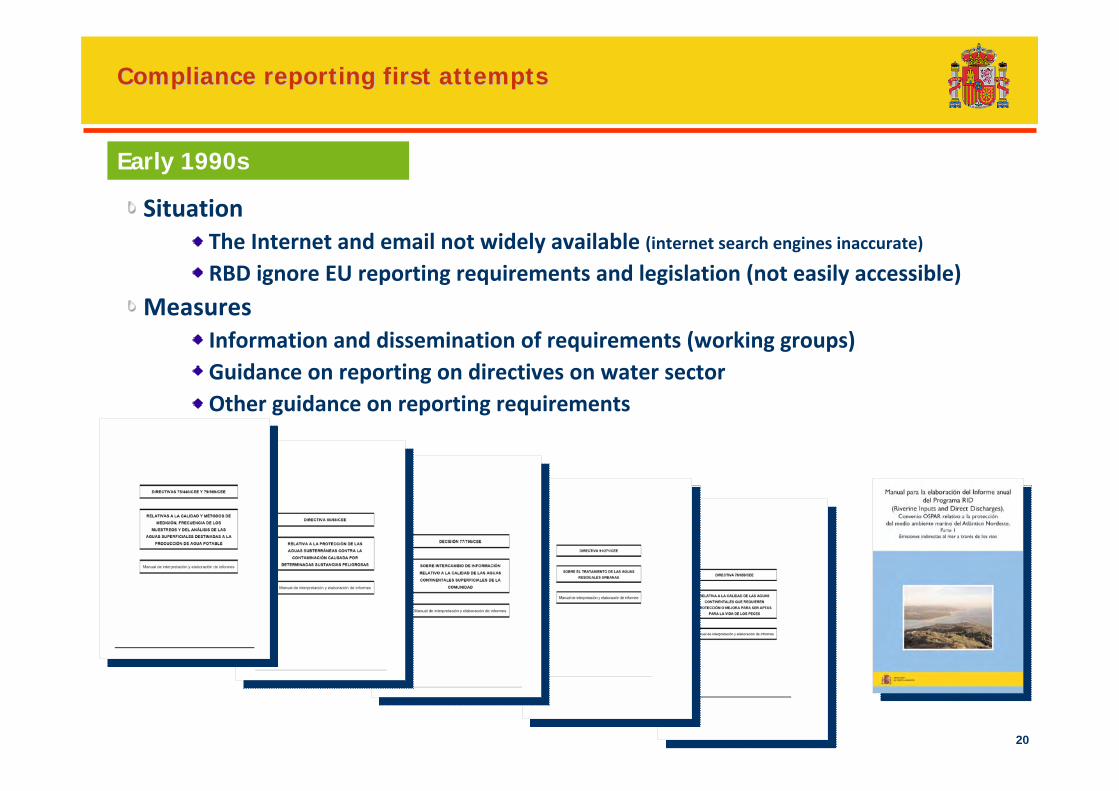
Compliance reporting first attemptsCompliance reporting first attempts
SituationThe Internet and email not widely available (internet search engines inaccurate)RBD ignore EU reporting requirements and legislation (not easily accessible)
MeasuresInformation and dissemination of requirements (working groups)Guidance on reporting on directives on water sectorOther guidance on reporting requirements
Early 1990s
21
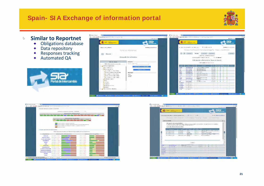
SpainSpain-- SIA Exchange of information portalSIA Exchange of information portal
Similar to ReportnetObligations databaseData repositoryResponses trackingAutomated QA
22
Waste water discharge informationin Spain
23
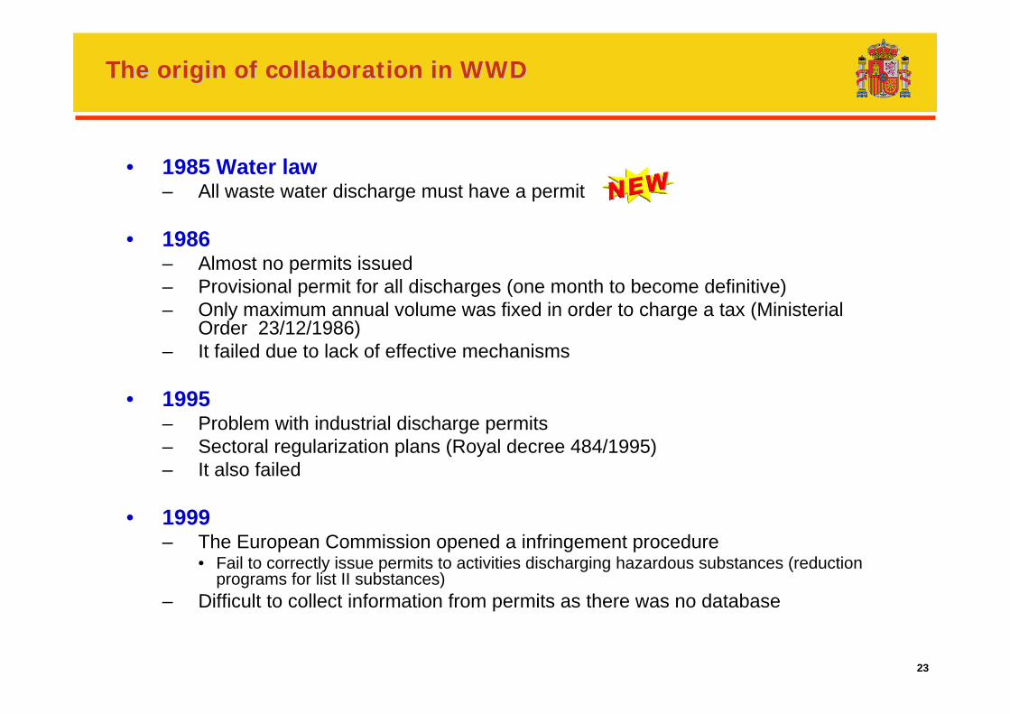
The origin of collaboration in WWDThe origin of collaboration in WWD
• 1985 Water law– All waste water discharge must have a permit
• 1986 – Almost no permits issued– Provisional permit for all discharges (one month to become definitive)– Only maximum annual volume was fixed in order to charge a tax (Ministerial
Order 23/12/1986)– It failed due to lack of effective mechanisms
• 1995– Problem with industrial discharge permits– Sectoral regularization plans (Royal decree 484/1995)– It also failed
• 1999– The European Commission opened a infringement procedure
• Fail to correctly issue permits to activities discharging hazardous substances (reduction programs for list II substances)
– Difficult to collect information from permits as there was no database
24
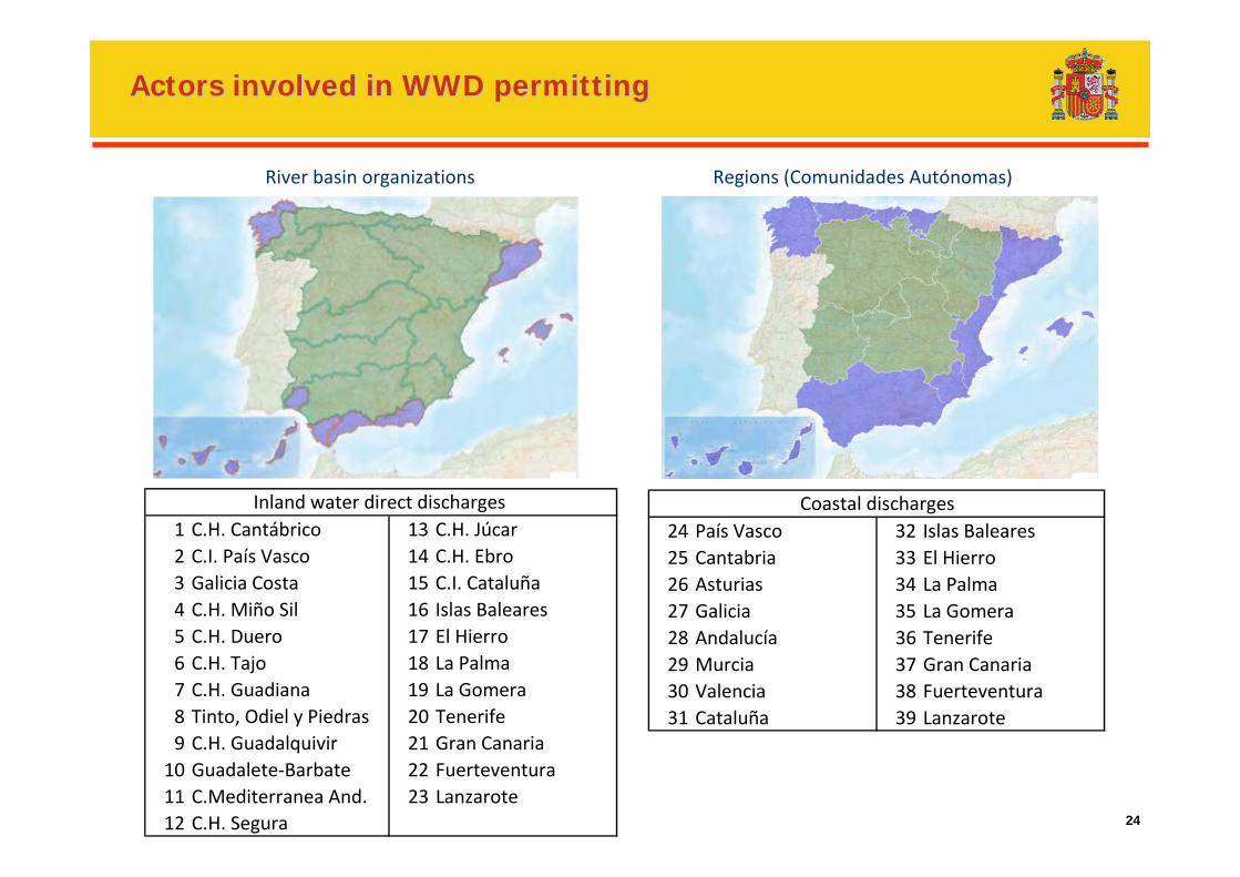
River basin organizations
Actors involved in WWD permittingActors involved in WWD permitting
Regions (Comunidades Autónomas)
1 C.H. Cantábrico 13 C.H. Júcar2 C.I. País Vasco 14 C.H. Ebro3 Galicia Costa 15 C.I. Cataluña4 C.H. Miño Sil 16 Islas Baleares5 C.H. Duero 17 El Hierro6 C.H. Tajo 18 La Palma7 C.H. Guadiana 19 La Gomera8 Tinto, Odiel y Piedras 20 Tenerife9 C.H. Guadalquivir 21 Gran Canaria10 Guadalete‐Barbate 22 Fuerteventura11 C.Mediterranea And. 23 Lanzarote 12 C.H. Segura
Inland water direct discharges 24 País Vasco 32 Islas Baleares25 Cantabria 33 El Hierro26 Asturias 34 La Palma27 Galicia 35 La Gomera28 Andalucía 36 Tenerife29 Murcia 37 Gran Canaria30 Valencia 38 Fuerteventura31 Cataluña 39 Lanzarote
Coastal discharges
25
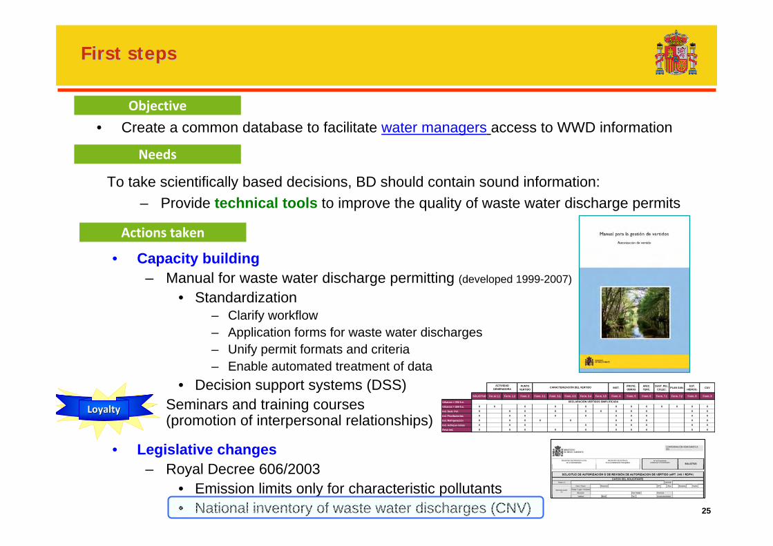
First stepsFirst steps
• Create a common database to facilitate water managers access to WWD information
• Capacity building– Manual for waste water discharge permitting (developed 1999-2007)
• Standardization– Clarify workflow– Application forms for waste water discharges– Unify permit formats and criteria – Enable automated treatment of data
• Decision support systems (DSS) – Seminars and training courses
(promotion of interpersonal relationships)
• Legislative changes– Royal Decree 606/2003
• Emission limits only for characteristic pollutants• National inventory of waste water discharges (CNV)
Objective
Needs
To take scientifically based decisions, BD should contain sound information:– Provide technical tools to improve the quality of waste water discharge permits
Actions taken
LoyaltyLoyalty
PUNTO VERTIDO INST. PROYE.
OBRASAFEC. TERC.
SUST. PEL. COLEC. PLAN SAN. EST.
HIDROG. CUV
SOLICITUD For.m 1.1 Form. 1.2 Form. 2 Form. 3.1. Form. 3.2. Form. 3.3. Form. 3.4 Form. 3.5 Form. 4 Form. 5 Form. 6 Form. 7.1 Form. 7.2 Form. 8 Form. 9
Urbanos < 250 h.e.
Urbanos > 250 h.e. X X X X X X X X X X X X
Ind. Sust. Pel. X X X X X X X X X X X
Ind. Piscifactorías X X X X X X X X X X
Ind. Refrigeración X X X X X X X X X X
Ind. Achique minas X X X X X X X X X
Reso ind. X X X X X X X X X X
ACTIVIDAD GENERADORA CARACTERIZACIÓN DEL VERTIDO
DECLARACIÓN VERTIDOS SIMPLIFICADA
26
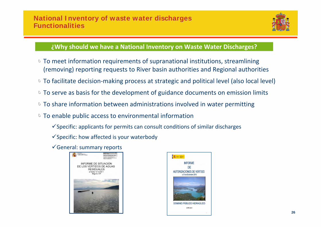
National Inventory of waste water dischargesNational Inventory of waste water dischargesFunctionalitiesFunctionalities
To meet information requirements of supranational institutions, streamlining (removing) reporting requests to River basin authorities and Regional authorities
To facilitate decision‐making process at strategic and political level (also local level)
To serve as basis for the development of guidance documents on emission limits
To share information between administrations involved in water permitting
To enable public access to environmental information
Specific: applicants for permits can consult conditions of similar discharges
Specific: how affected is your waterbody
General: summary reports
¿Why should we have a National Inventory on Waste Water Discharges?
27
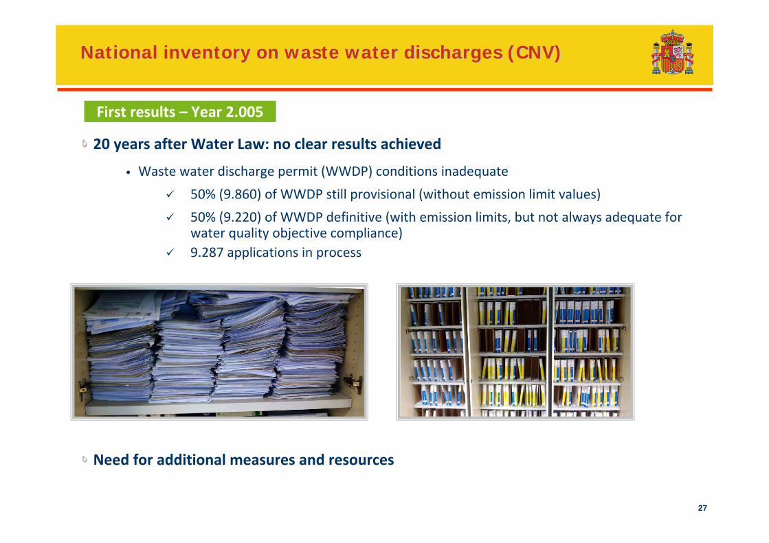
National inventory on waste water discharges (CNV)National inventory on waste water discharges (CNV)
20 years after Water Law: no clear results achieved
• Waste water discharge permit (WWDP) conditions inadequate
50% (9.860) of WWDP still provisional (without emission limit values)
50% (9.220) of WWDP definitive (with emission limits, but not always adequate for water quality objective compliance)9.287 applications in process
First results – Year 2.005
Need for additional measures and resources
28
National inventory on waste water discharges (CNV)National inventory on waste water discharges (CNV)
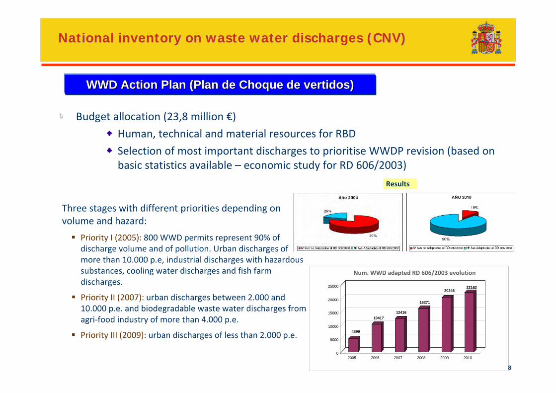
Budget allocation (23,8 million €)
Human, technical and material resources for RBD
Selection of most important discharges to prioritise WWDP revision (based on basic statistics available – economic study for RD 606/2003)
WWD Action PlanWWD Action Plan (Plan de Choque de vertidos)(Plan de Choque de vertidos)
Three stages with different priorities depending on volume and hazard:
Priority I (2005): 800 WWD permits represent 90% of discharge volume and of pollution. Urban discharges of more than 10.000 p.e, industrial discharges with hazardous substances, cooling water discharges and fish farm discharges.
Priority II (2007): urban discharges between 2.000 and 10.000 p.e. and biodegradable waste water discharges from agri‐food industry of more than 4.000 p.e.
Priority III (2009): urban discharges of less than 2.000 p.e.
Results
4899
1041712416
16271
2024622162
0
5000
10000
15000
20000
25000
2005 2006 2007 2008 2009 2010
Num. WWD adapted RD 606/2003 evolution
29
National inventory on waste water discharges (CNV)National inventory on waste water discharges (CNV)
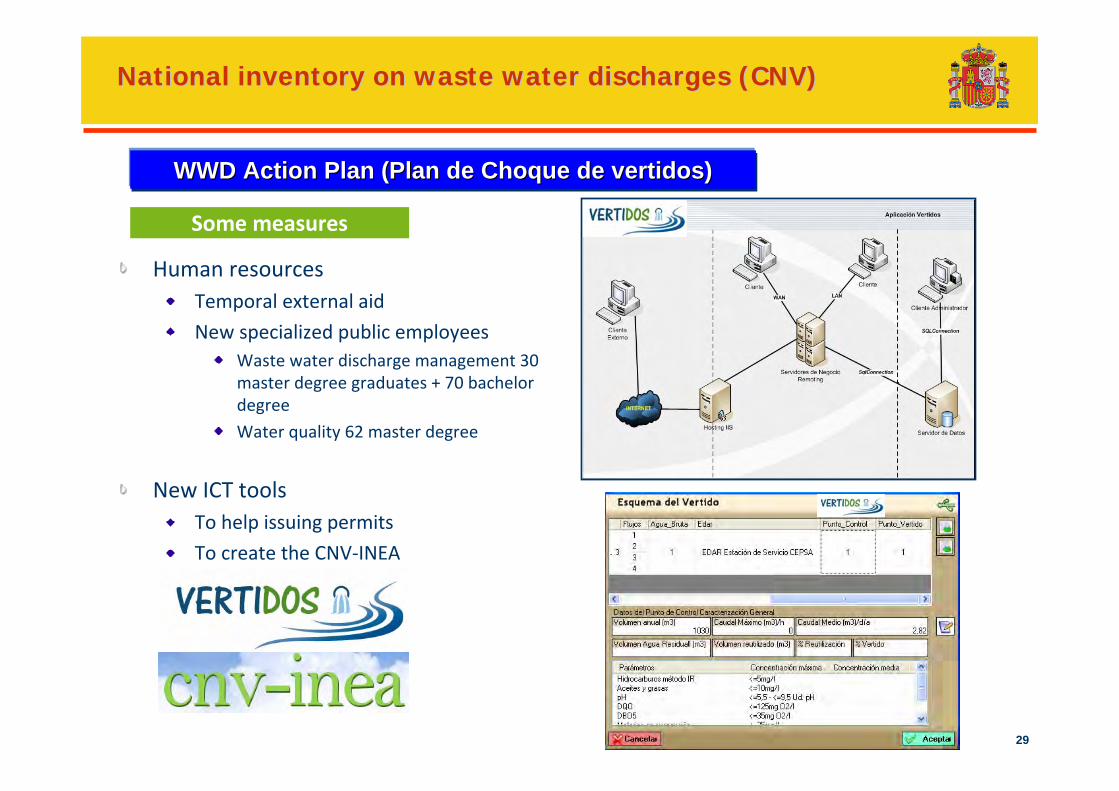
Human resourcesTemporal external aid
New specialized public employeesWaste water discharge management 30 master degree graduates + 70 bachelor degree
Water quality 62 master degree
New ICT toolsTo help issuing permits
To create the CNV‐INEA
WWD Action PlanWWD Action Plan (Plan de Choque de vertidos)(Plan de Choque de vertidos)
Some measures
30
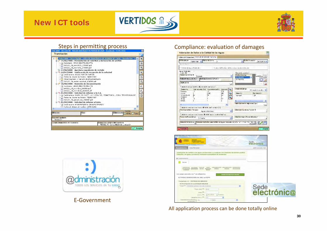
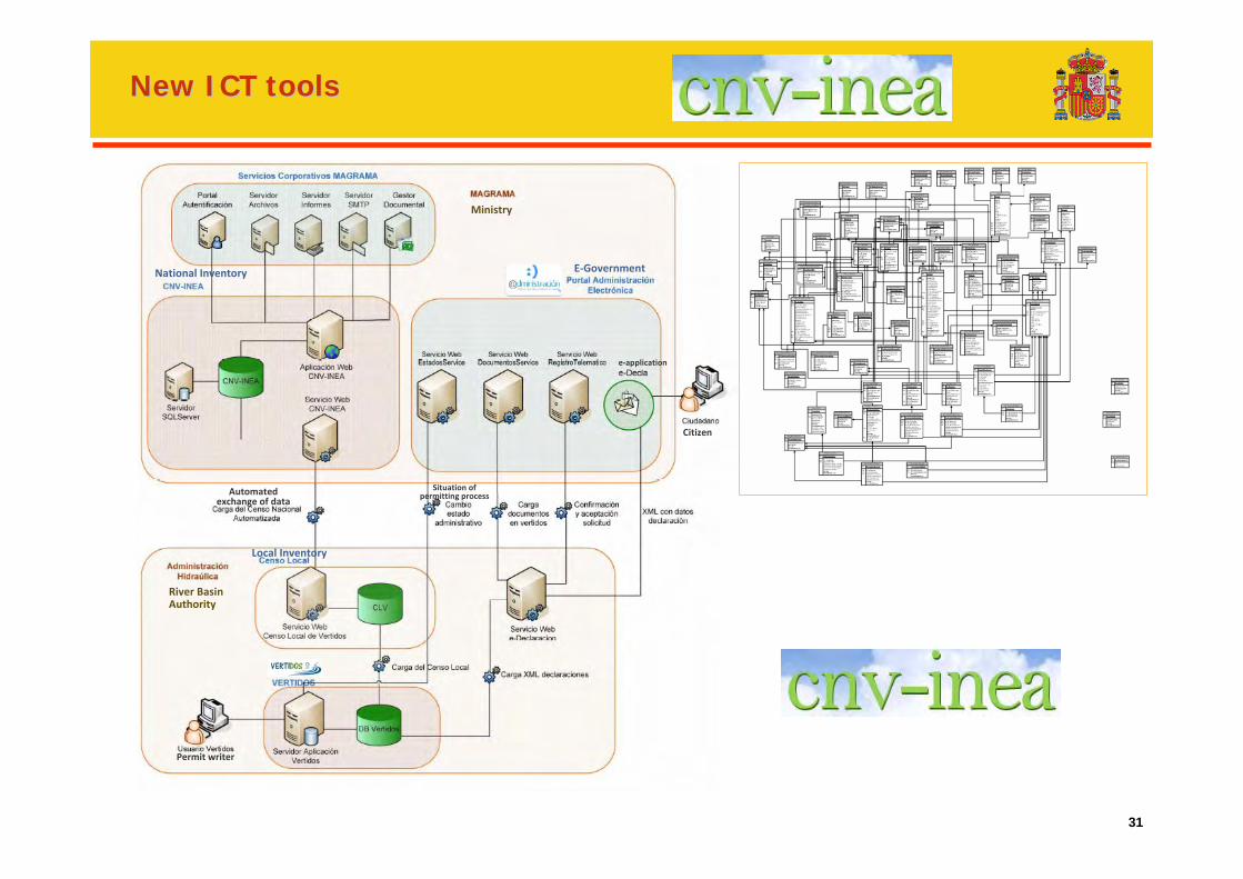
NewNew ICT ICT toolstools
Steps in permitting process Compliance: evaluation of damages
E‐GovernmentAll application process can be done totally online
31
NewNew ICT ICT toolstools
E‐Government
Ministry
River Basin Authority
Local Inventory
Permit writer
Citizen
Automated exchange of data
National Inventory
Situation of permitting process
e‐application
32
Compliance reporting in SpainUrban waste water discharge information
(Directive 91/271/CEE)
33
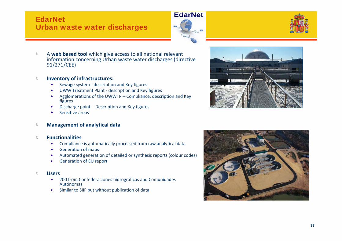
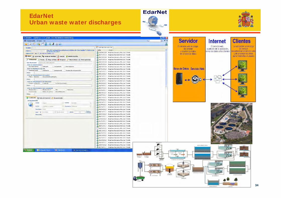
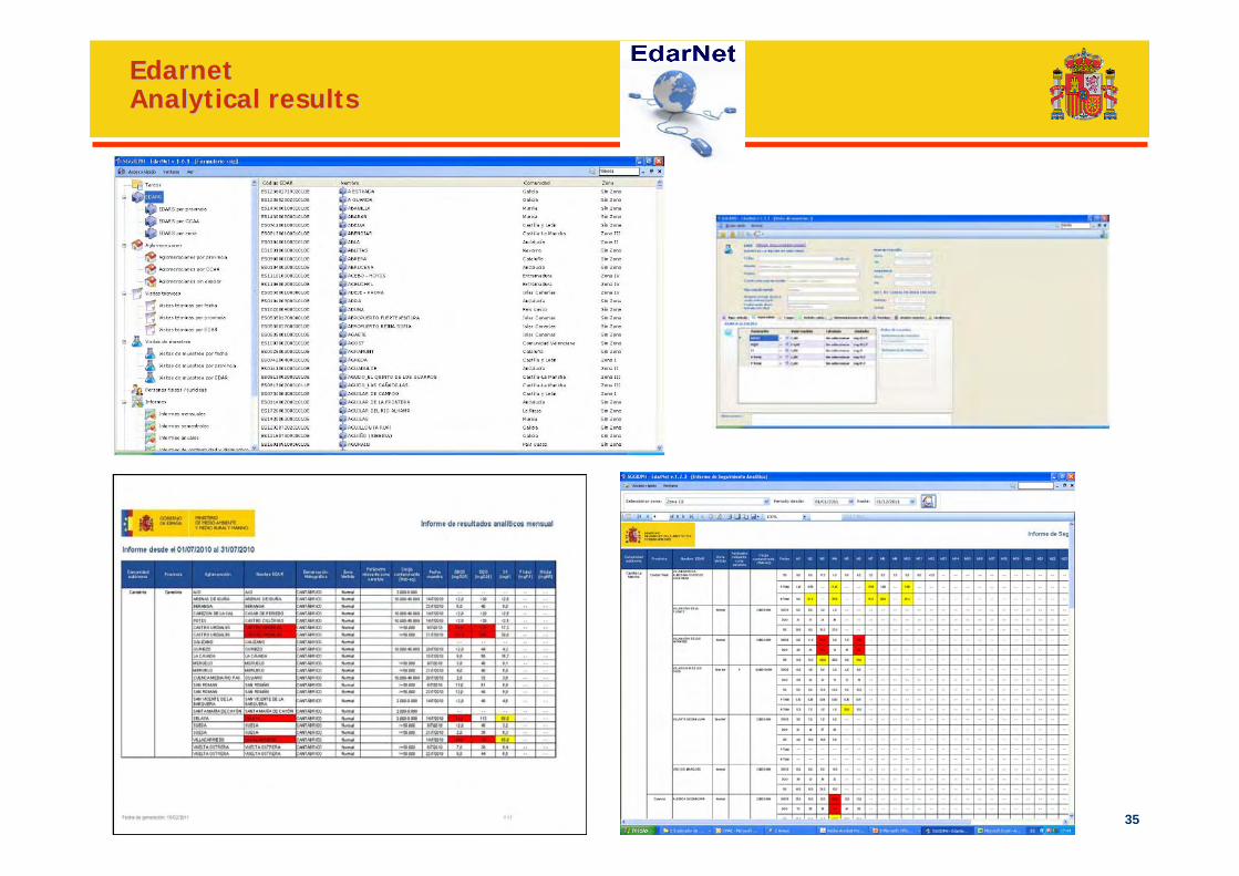
EdarNetUrban waste water discharges
A web based tool which give access to all national relevant information concerning Urban waste water discharges (directive 91/271/CEE)
Inventory of infrastructures:Sewage system ‐ description and Key figures UWW Treatment Plant ‐ description and Key figures Agglomerations of the UWWTP – Compliance, description and Key figures Discharge point ‐ Description and Key figures Sensitive areas
Management of analytical data
FunctionalitiesCompliance is automatically processed from raw analytical dataGeneration of mapsAutomated generation of detailed or synthesis reports (colour codes)Generation of EU report
Users200 from Confederaciones hidrográficas and ComunidadesAutónomasSimilar to SIIF but without publication of data
34
EdarNetUrban waste water discharges
35
EdarnetEdarnetAnalytical resultsAnalytical results
36
Water rights in Spain
37
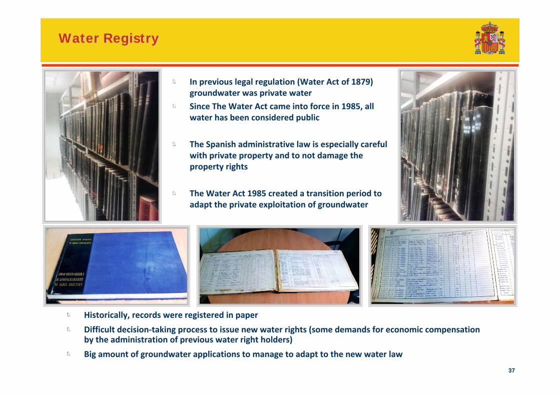
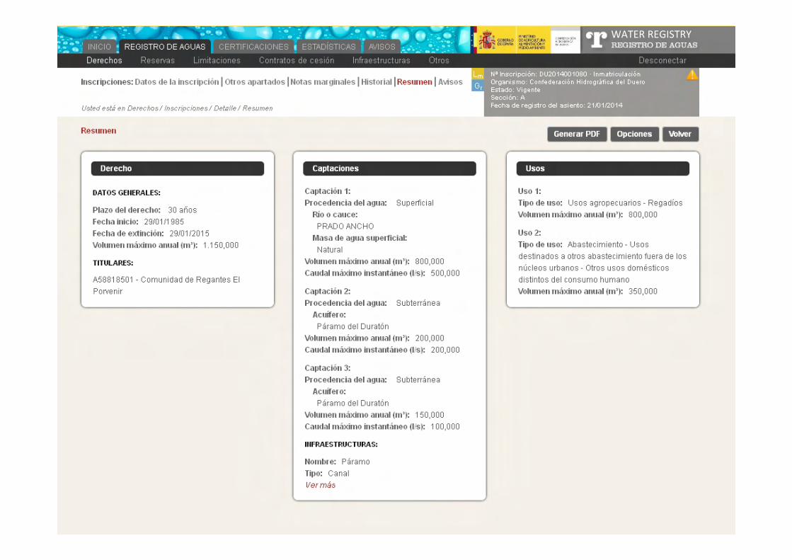
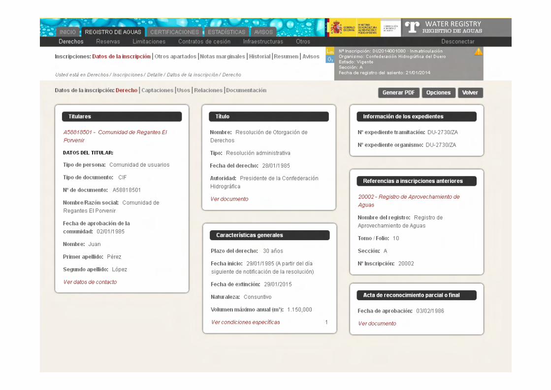
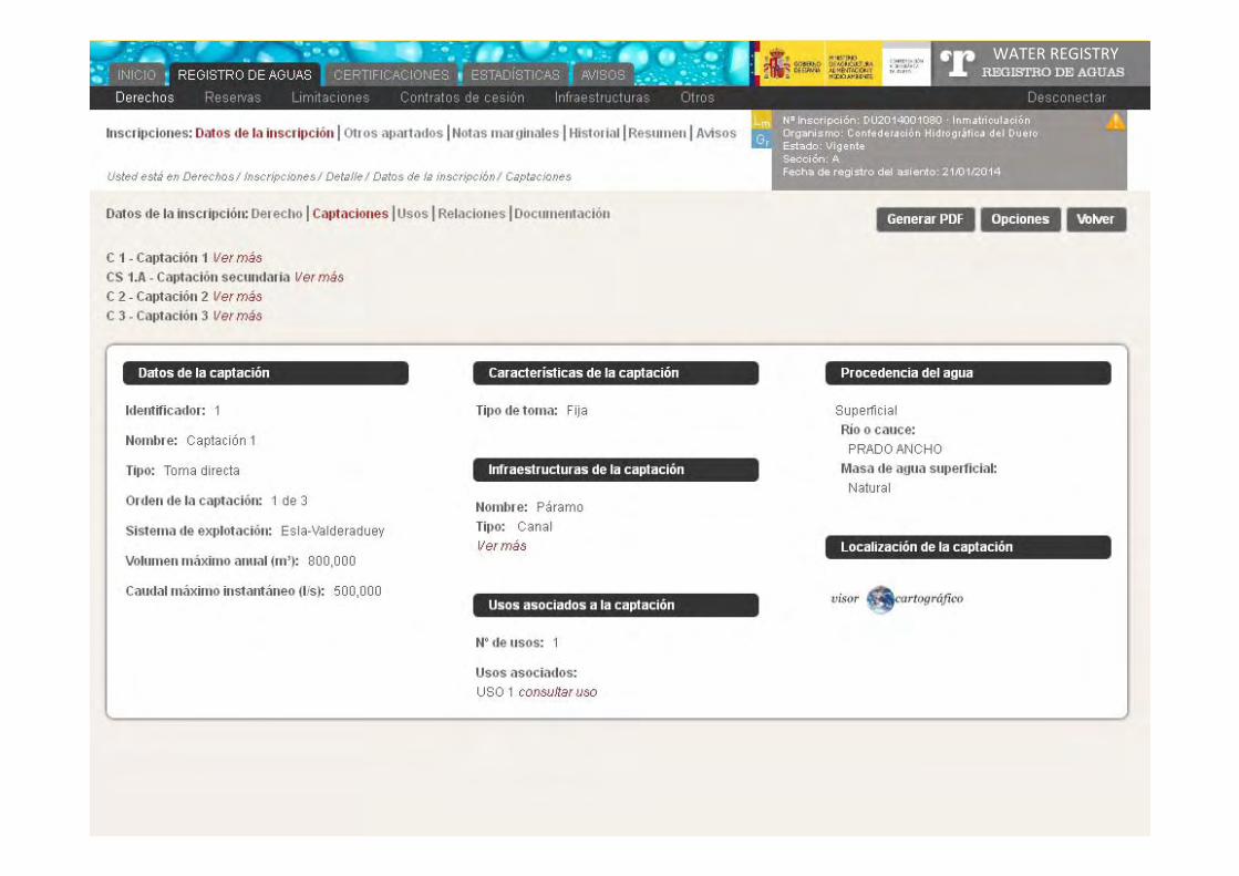
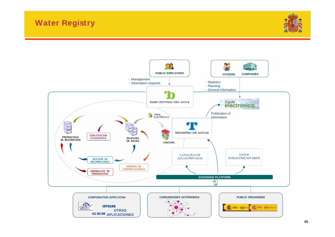
Water RegistryWater Registry
In previous legal regulation (Water Act of 1879) groundwater was private water
Since The Water Act came into force in 1985, all water has been considered public
The Spanish administrative law is especially careful with private property and to not damage the property rights
The Water Act 1985 created a transition period to adapt the private exploitation of groundwater
Historically, records were registered in paper
Difficult decision‐taking process to issue new water rights (some demands for economic compensation by the administration of previous water right holders)
Big amount of groundwater applications to manage to adapt to the new water law
38
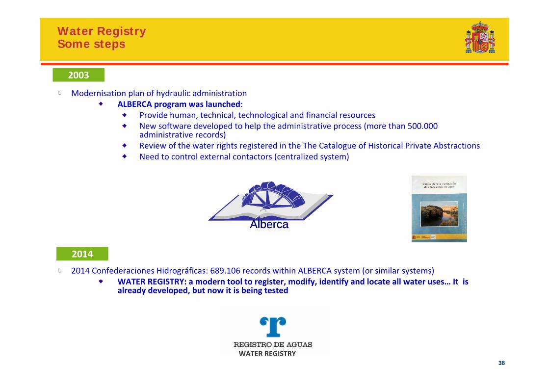
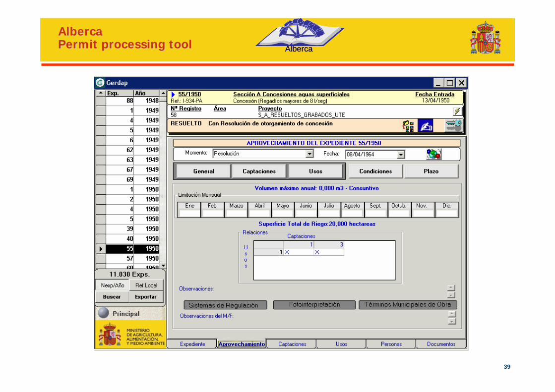
Modernisation plan of hydraulic administrationALBERCA program was launched:
Provide human, technical, technological and financial resourcesNew software developed to help the administrative process (more than 500.000 administrative records)Review of the water rights registered in the The Catalogue of Historical Private AbstractionsNeed to control external contactors (centralized system)
2014 Confederaciones Hidrográficas: 689.106 records within ALBERCA system (or similar systems)WATER REGISTRY: a modern tool to register, modify, identify and locate all water uses… It is already developed, but now it is being tested
AlbercaAlberca
Water RegistryWater RegistrySome stepsSome steps
2003
2014
WATER REGISTRY
39
AlbercaAlbercaPermit processing toolPermit processing tool AlbercaAlberca
40
WATER REGISTRY
41
WATER REGISTRY
42
WATER REGISTRY
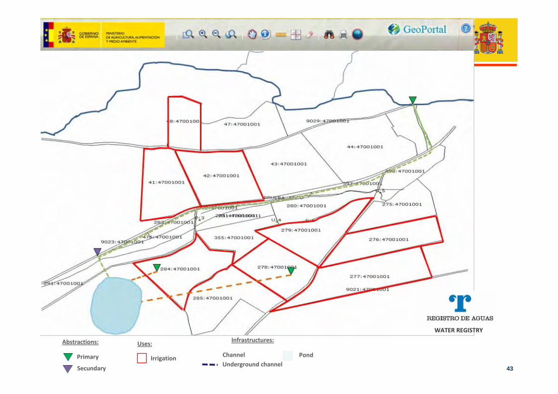
43Irrigation
Uses:
Channel Pond
Infrastructures:
Underground channelSecundary
Primary
Abstractions:
WATER REGISTRY
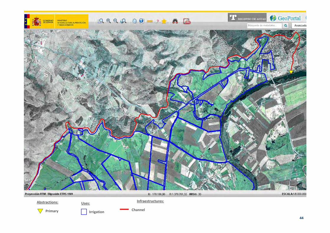
44Irrigation
Uses: Infraestructures:
Primary
Abstractions:
Channel
45
PUBLIC ORGANISMSCOMUNIDADES AUTÓNOMASCORPORATIVE APPS CCHH
EXCHANGE PLATFORM
COMPANIESCITIZENSPUBLIC EMPLOYEES
- Management- Information requests - Statistics
- Planning- General information
Publication of information
CATALOGO DE AGUAS PRIVADAS
DATOS INTRACOMUNITARIOS
INTEGRAOTRAS
APLICACIONESGEN
Water RegistryWater Registry
46
Water quality and water status informationin Spain
47
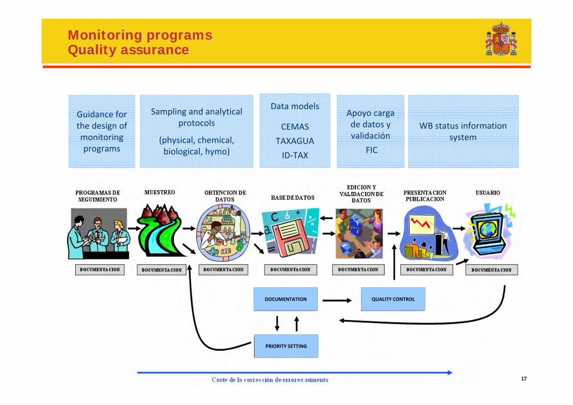
Monitoring programsMonitoring programsQuality assuranceQuality assurance
Apoyo carga de datos y validación
FIC
Sampling and analytical protocols
(physical, chemical, biological, hymo)
Data models
CEMAS
TAXAGUA
ID‐TAX
WB status informationsystem
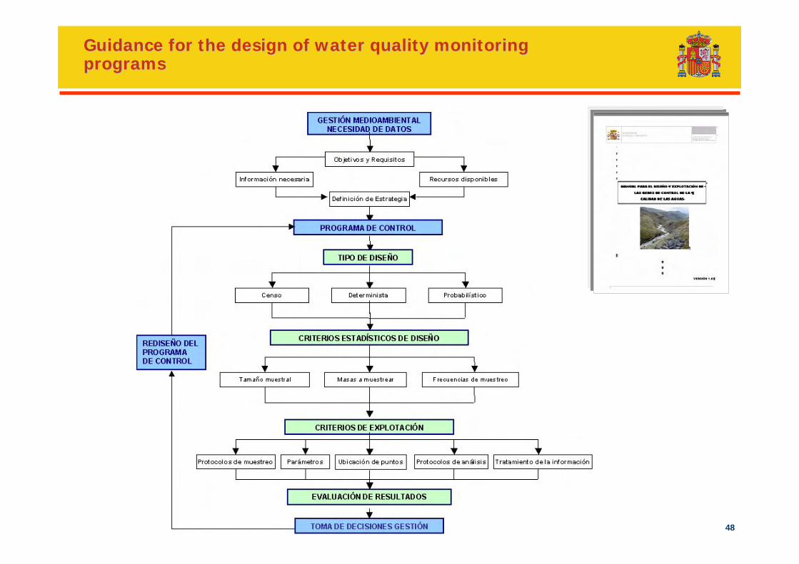
Guidance for the design of monitoring programs
MONITORING PROGRAMS
SAMPLING DATA ACQUISITION DATA BASEDATA EDITION AND
VALIDATIONPRESENTATION AND
PUBLICATION USER
DOCUMENTATION DOCUMENTATIONDOCUMENTATIONDOCUMENTATION DOCUMENTATION DOCUMENTATION DOCUMENTATION
DOCUMENTATION QUALITY CONTROL
PRIORITY SETTING
48
Guidance for the design of water quality monitoring Guidance for the design of water quality monitoring programsprograms
49
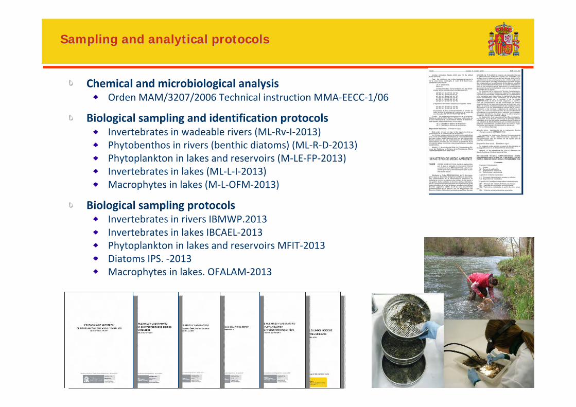
Sampling and analytical protocolsSampling and analytical protocols
Chemical and microbiological analysisOrden MAM/3207/2006 Technical instruction MMA‐EECC‐1/06
Biological sampling and identification protocolsInvertebrates in wadeable rivers (ML‐Rv‐I‐2013)Phytobenthos in rivers (benthic diatoms) (ML‐R‐D‐2013)Phytoplankton in lakes and reservoirs (M‐LE‐FP‐2013)Invertebrates in lakes (ML‐L‐I‐2013)Macrophytes in lakes (M‐L‐OFM‐2013)
Biological sampling protocolsInvertebrates in rivers IBMWP.2013Invertebrates in lakes IBCAEL‐2013Phytoplankton in lakes and reservoirs MFIT‐2013Diatoms IPS. ‐2013Macrophytes in lakes. OFALAM‐2013
50
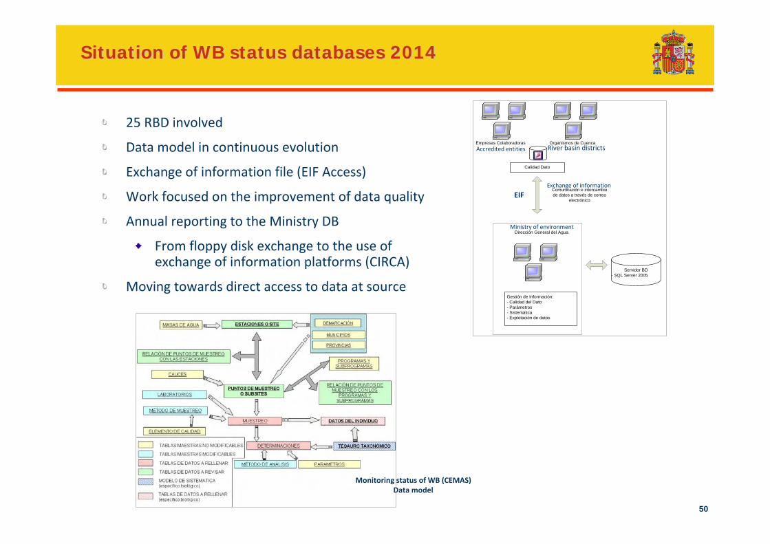
Situation of WB status databases 2014Situation of WB status databases 2014
Empresas Colaboradoras
Calidad Dato
Organismos de Cuenca
Gestión de Información:- Calidad del Dato- Parámetros- Sistemática- Explotación de datos
Servidor BD- SQL Server 2005
Dirección General del Agua
Comunicación e intercambio de datos a través de correo
electrónico
25 RBD involved
Data model in continuous evolution
Exchange of information file (EIF Access)
Work focused on the improvement of data quality
Annual reporting to the Ministry DB
From floppy disk exchange to the use of exchange of information platforms (CIRCA)
Moving towards direct access to data at source
Monitoring status of WB (CEMAS)Data model
EIF
River basin districtsAccredited entities
Exchange of information
Ministry of environment
51
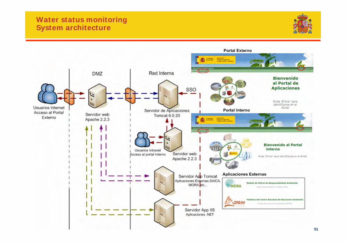
Water status monitoringWater status monitoringSystem architectureSystem architecture
52
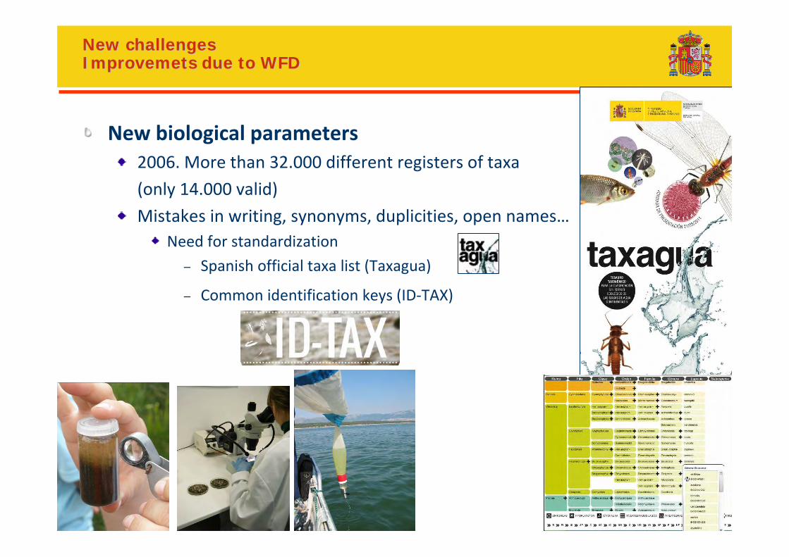
New challenges New challenges ImprovemetsImprovemets due to WFDdue to WFD
New biological parameters2006. More than 32.000 different registers of taxa
(only 14.000 valid)
Mistakes in writing, synonyms, duplicities, open names…Need for standardization
– Spanish official taxa list (Taxagua)
– Common identification keys (ID‐TAX)
53
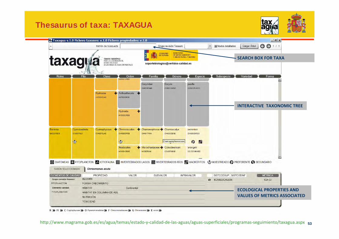
Thesaurus of Thesaurus of taxataxa: TAXAGUA: TAXAGUA
SEARCH BOX FOR TAXA
INTERACTIVE TAXONOMIC TREE
ECOLOGICAL PROPERTIES AND VALUES OF METRICS ASSOCIATED
http://www.magrama.gob.es/es/agua/temas/estado‐y‐calidad‐de‐las‐aguas/aguas‐superficiales/programas‐seguimiento/taxagua.aspx
54
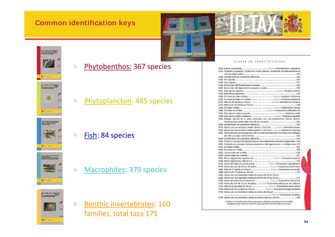
Common identification keysCommon identification keys
Phytobenthos: 367 species
Phytoplancton: 485 species
Fish: 84 species
Macrophites: 379 species
Benthic invertebrates: 160 families, total taza 175
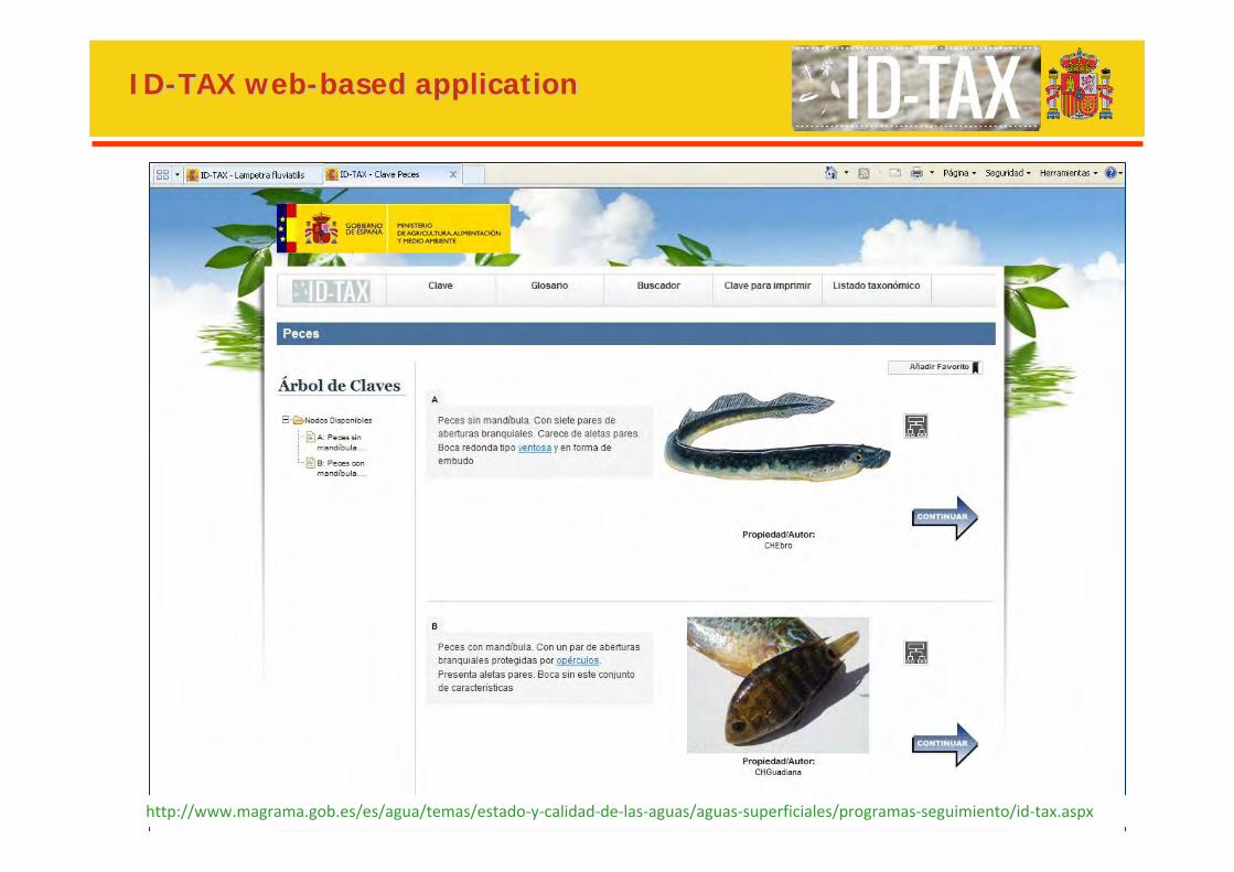
55http://www.magrama.gob.es/es/agua/temas/estado‐y‐calidad‐de‐las‐aguas/aguas‐superficiales/programas‐seguimiento/id‐tax.aspx
IDID--TAX TAX webweb--based applicationbased application
56 56
Programs of measuresWFD river basin management plans
in Spain
57
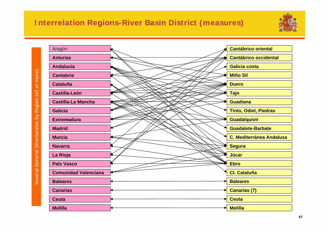
Interrelation RegionsInterrelation Regions--River Basin District (measures)River Basin District (measures)
AragAragóónn
Asturias
Andalucía
Cantabria
Cataluña
Castilla-La Mancha
Comunidad Valenciana
Castilla-León
Galicia
Extremadura
Madrid
Murcia
Navarra
La Rioja
País Vasco
Baleares
Canarias
Ceuta
Melilla
Cantábrico oriental
Cantábrico occidental
Galicia costa
Duero
Tajo
Guadiana
Tinto, Odiel, Piedras
Guadalquivir
C. Mediterránea Andaluza
Segura
Júcar
Ebro
CI. Cataluña
Baleares
Canarias (7)
Ceuta
Melilla
Miño Sil
Guadalete-Barbate
Several G
eneral Directorates by
Region (x5 or m
ore)
58
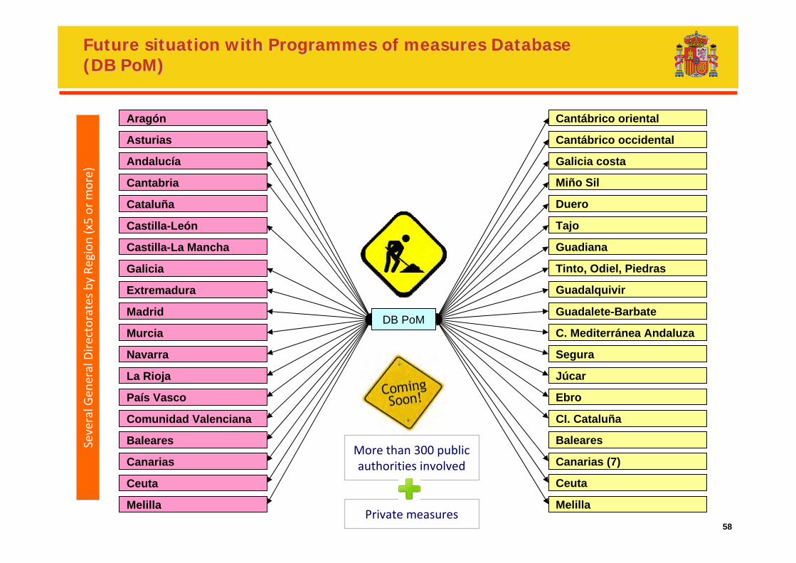
FutureFuture situationsituation withwith ProgrammesProgrammes ofof measuresmeasures DatabaseDatabase(DB (DB PoMPoM))
Aragón
Asturias
Andalucía
Cantabria
Cataluña
Castilla-La Mancha
Comunidad Valenciana
Castilla-León
Galicia
Extremadura
Madrid
Murcia
Navarra
La Rioja
País Vasco
Baleares
Canarias
Ceuta
Melilla
Cantábrico oriental
Cantábrico occidental
Galicia costa
Duero
Tajo
Guadiana
Tinto, Odiel, Piedras
Guadalquivir
C. Mediterránea Andaluza
Segura
Júcar
Ebro
CI. Cataluña
Baleares
Canarias (7)
Ceuta
Melilla
Miño Sil
Guadalete-BarbateDB PoM
Several G
eneral Directorates by
Region (x5 or m
ore)
More than 300 public authorities involved
Private measures
59
Spatial datasetsInspire directive in Spain
60
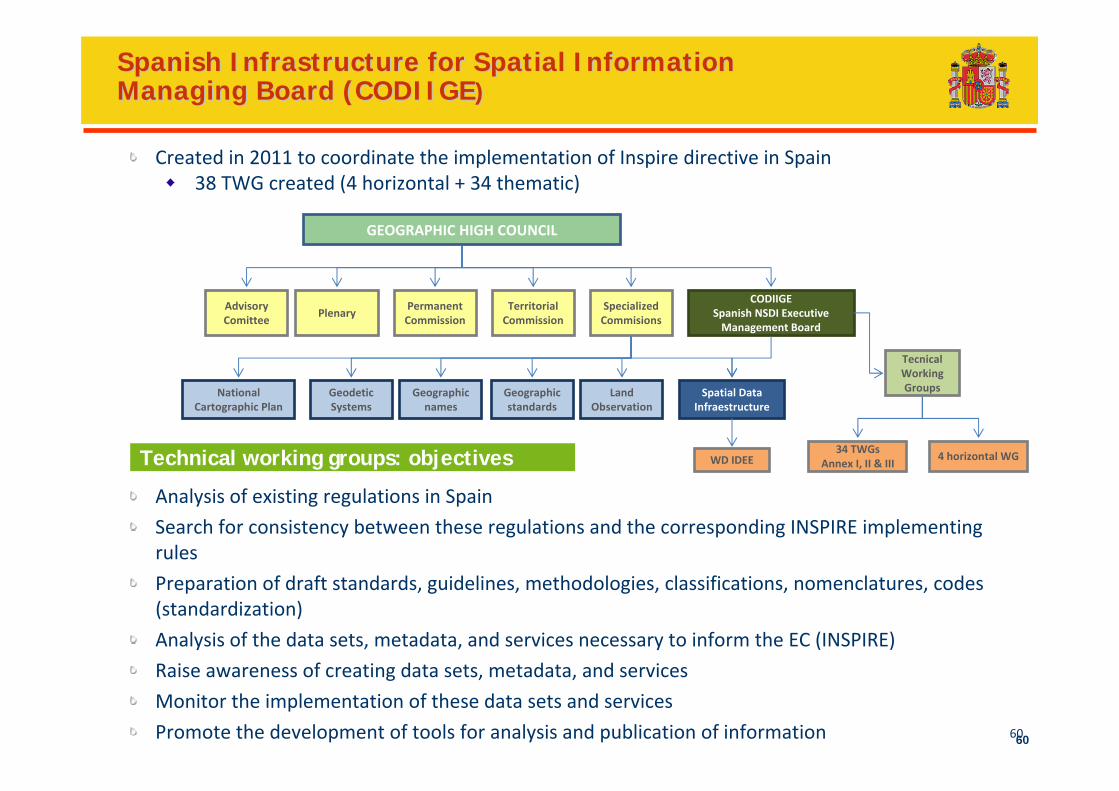
Spanish Infrastructure for Spatial Information Spanish Infrastructure for Spatial Information Managing Board (CODIIGEManaging Board (CODIIGE))
Analysis of existing regulations in Spain
Search for consistency between these regulations and the corresponding INSPIRE implementing rules
Preparation of draft standards, guidelines, methodologies, classifications, nomenclatures, codes (standardization)
Analysis of the data sets, metadata, and services necessary to inform the EC (INSPIRE)
Raise awareness of creating data sets, metadata, and services
Monitor the implementation of these data sets and services
Promote the development of tools for analysis and publication of information 60
Technical working groups: objectives
Created in 2011 to coordinate the implementation of Inspire directive in Spain38 TWG created (4 horizontal + 34 thematic)
GEOGRAPHIC HIGH COUNCIL
PlenaryPermanentCommission
Territorial Commission
SpecializedCommisions
AdvisoryComittee
CODIIGESpanish NSDI ExecutiveManagement Board
GeodeticSystems
Geographic names
NationalCartographic Plan
Land Observation
Geographic standards
Spatial Data Infraestructure
WD IDEE
TecnicalWorkingGroups
34 TWGsAnnex I, II & III
4 horizontal WG
61
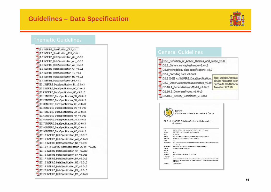
Guidelines Guidelines –– Data SpecificationData Specification
Thematic Guidelines
General Guidelines
62
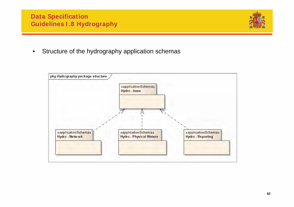
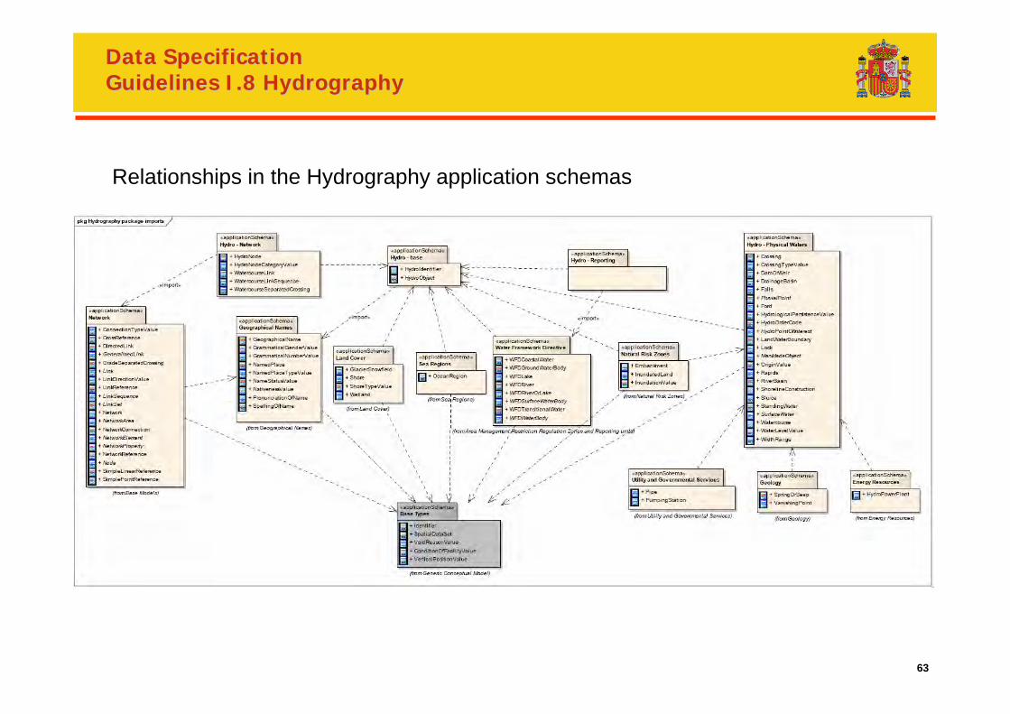
Data Specification Data Specification Guidelines I.8 Guidelines I.8 HydrographyHydrography
• Structure of the hydrography application schemas
63
Data Specification Data Specification Guidelines I.8 Guidelines I.8 HydrographyHydrography
Relationships in the Hydrography application schemas
64
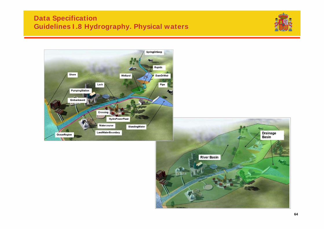
Data Specification Data Specification Guidelines I.8 Guidelines I.8 HydrographyHydrography. Physical waters. Physical waters
65
Data Specification Data Specification Guidelines I.8 Guidelines I.8 HydrographyHydrography. Physical waters. Physical waters
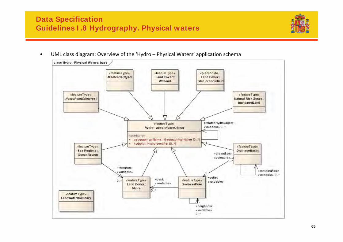
• UML class diagram: Overview of the ‘Hydro – Physical Waters’ application schema
66
Data Specification Data Specification Guidelines I.8 Guidelines I.8 HydrographyHydrography. Physical waters. Physical waters
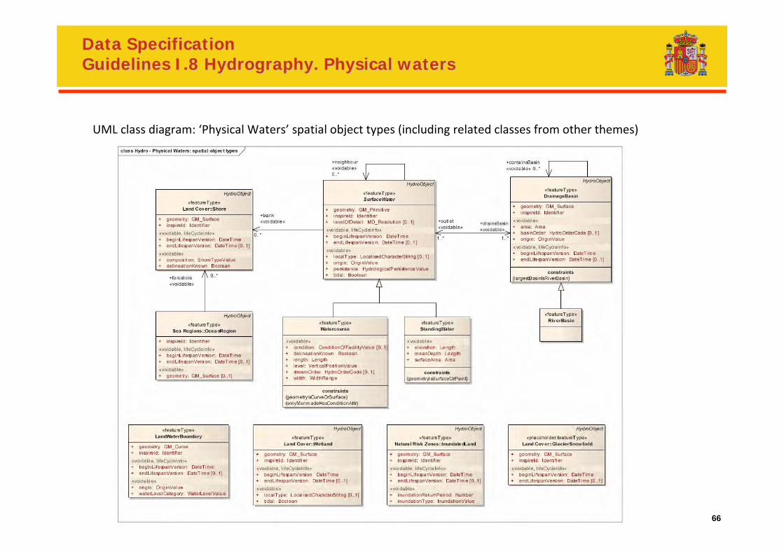
UML class diagram: ‘Physical Waters’ spatial object types (including related classes from other themes)
67
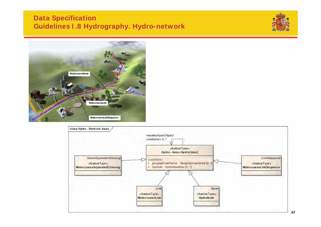
Data Specification Data Specification Guidelines I.8 Guidelines I.8 HydrographyHydrography.. HydroHydro--networknetwork
68
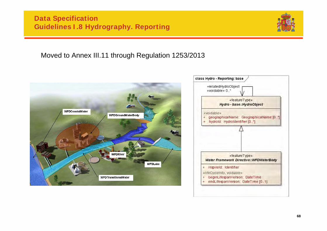
Data Specification Data Specification Guidelines I.8 Guidelines I.8 HydrographyHydrography.. ReportingReporting
Moved to Annex III.11 through Regulation 1253/2013
69
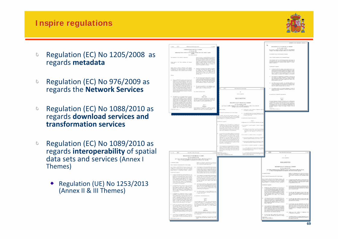
Inspire Inspire regulationsregulations
Regulation (EC) No 1205/2008 as regardsmetadata
Regulation (EC) No 976/2009 as regards the Network Services
Regulation (EC) No 1088/2010 as regards download services andtransformation services
Regulation (EC) No 1089/2010 as regards interoperability of spatial data sets and services (Annex I Themes)
Regulation (UE) No 1253/2013 (Annex II & III Themes)
70
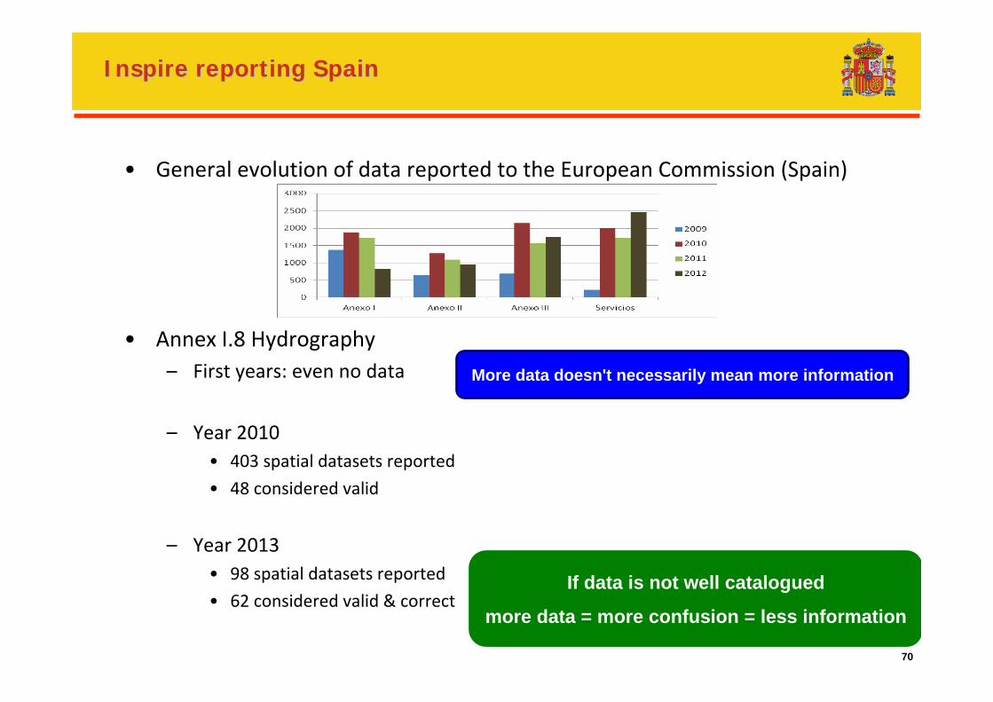
Inspire Inspire reportingreporting SpainSpain
• General evolution of data reported to the European Commission (Spain)
• Annex I.8 Hydrography– First years: even no data
– Year 2010• 403 spatial datasets reported
• 48 considered valid
– Year 2013• 98 spatial datasets reported
• 62 considered valid & correct
More data doesn't necessarily mean more information
If data is not well catalogued
more data = more confusion = less information
71
Open collaborative productionNon born initiatives
72
Open collaborative productionOpen collaborative productionNon born initiativesNon born initiatives
Phytoplankton: assessment of frequency of algal blooms (WFD requirement)
ID‐TAX: not all levels of taxonomic identification had a good photographs
Collaborative completion of inventory of pressures (e.g. abandoned little dams)
Difficulties of public authorities to cover the hole territory or hole information
Why haven’t they succeed yet?
Difficulties for quality control
Algal blooms: possible confusion in the name of the lake/reservoir, missspellings in names, foam (pollution or algal bloom?)..
ID‐TAX photos: possible mistakes of taxonomic classification, mistakes encoding photos…
Small differences in coordinates produce two objects…
A reviewing system has to be put in place
Does it worth the information gained?
Need for automated reviewing or volunteer reviewing community or…(any idea?)
More data can be less information
73
Some possible conclusions
74
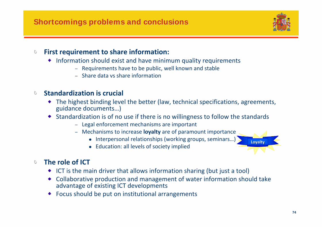
Shortcomings problems and conclusionsShortcomings problems and conclusions
First requirement to share information:Information should exist and have minimum quality requirements
– Requirements have to be public, well known and stable– Share data vs share information
Standardization is crucialThe highest binding level the better (law, technical specifications, agreements, guidance documents…)Standardization is of no use if there is no willingness to follow the standards
– Legal enforcement mechanisms are important– Mechanisms to increase loyalty are of paramount importance
Interpersonal relationships (working groups, seminars…)Education: all levels of society implied
The role of ICTICT is the main driver that allows information sharing (but just a tool)Collaborative production and management of water information should take advantage of existing ICT developmentsFocus should be put on institutional arrangements
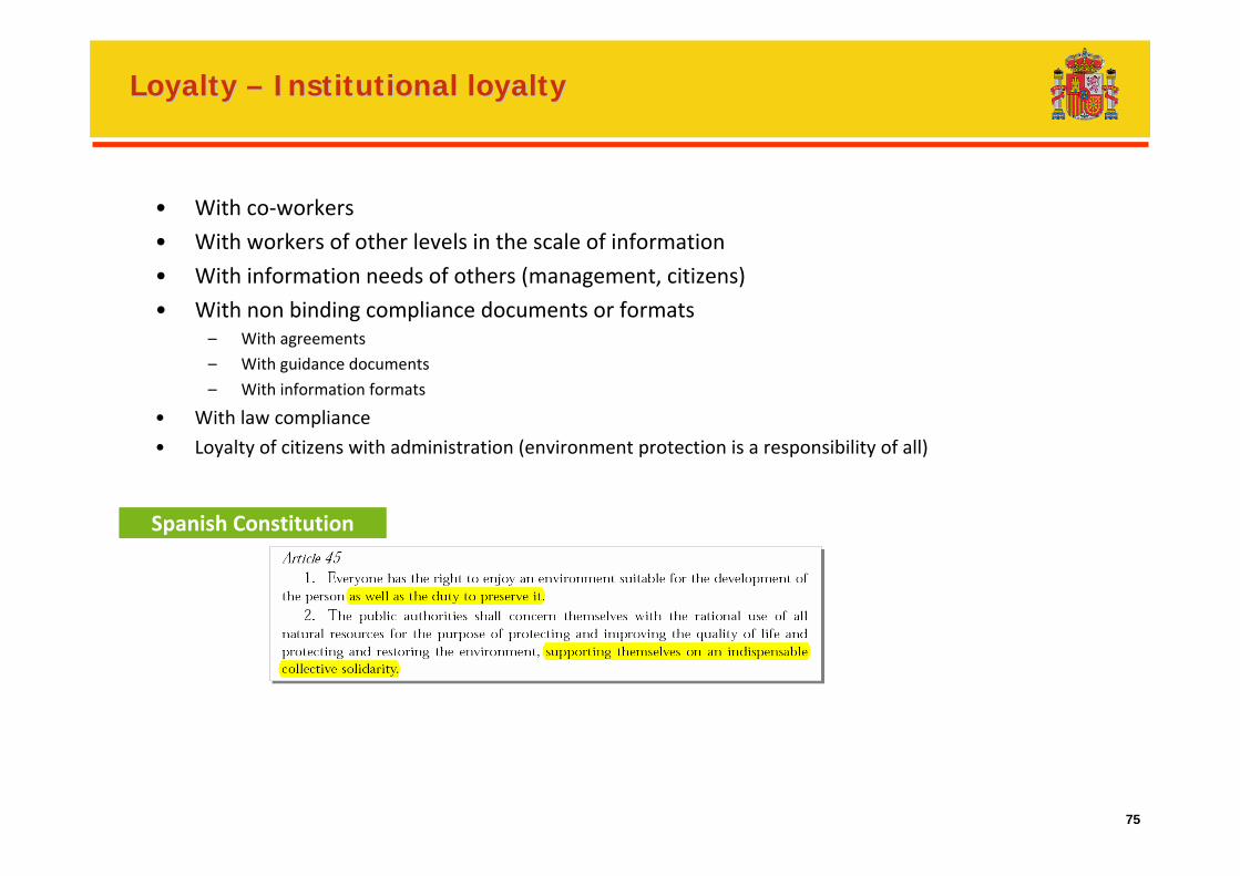
LoyaltyLoyalty
75
Loyalty Loyalty –– Institutional loyaltyInstitutional loyalty
• With co‐workers
• With workers of other levels in the scale of information
• With information needs of others (management, citizens)
• With non binding compliance documents or formats– With agreements
– With guidance documents
– With information formats
• With law compliance
• Loyalty of citizens with administration (environment protection is a responsibility of all)
Spanish Constitution
76
Public participation and access to dataPublic participation and access to data
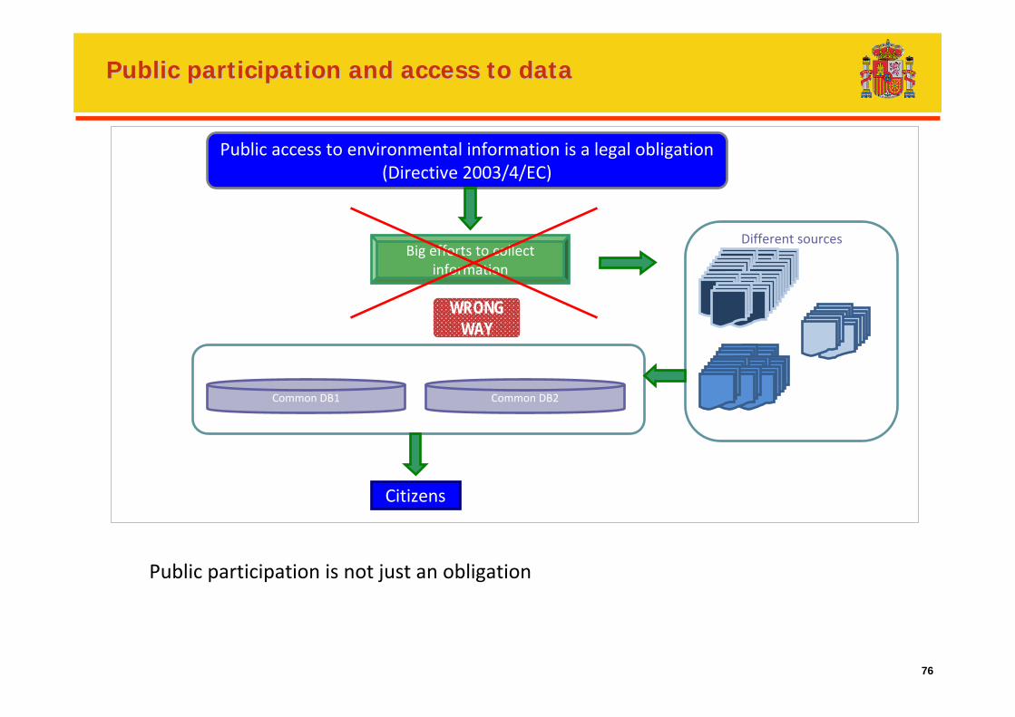
Public access to environmental information is a legal obligation(Directive 2003/4/EC)
Big efforts to collect information
Citizens
Common DB1 Common DB2
Different sources
WRONGWAY
Public participation is not just an obligation
77
Public participation and access to dataPublic participation and access to dataConclusionsConclusions
To make polycentric information available to managers, agencies and the public
Data information systems have to offer the data producer an advantage for using itData information systems have to take account of data needs of all actors involvedData collection shouldn't be oriented only to:
Reporting purposes (compliance reporting should be just one of the outputs the systems)Comply with public access to environmental data
Data should be collected for management, planning or policy definition purposesData as a means to an endAll levels of decision have to be involved (Policy makers, managers, stakeholders, water users, NGOs, citizens…). Consensus on strategy
Reporting has to be a consequence of the work carried outReporting shouldn't be a time consuming effort Reporting should be “transparent” for the producer of the information
Public access to data has to be seen as a way to improve water management (public access to information as a means to an end)
There is a need that public authorities and citizens believe this way of thinking
Public authorities and citizens should have the commitment to work togetherNeed for loyalty in this relationship
78
Thank you!
Ruza river
Javier Ruza RodríguezHead of Unit for Management and CooperationDeputy Directorate‐General for Water Planning and Sustainable Use of Water Directorate‐General for WaterMinistry of Agriculture, Food and Environment(Spain)[email protected]