Embed Size (px)
Citation preview
Port and Harbor Bureau, Osaka Prefectural GovernmentDepartment of General Affairs / Department of Project Management6-1 Nagisa-cho, Izumiotsu City 595-0055
(Sakai-Semboku Port Service Center Bldg. 10F)
TEL: 0725-21-1411 FAX: 0725-21-7259
Department of Planning3-2-12 Otemae, Chuo-ku, Osaka 540-8570(Annex 7th floor)
TEL: 06-6941-0351 (Osaka Prefectural Government) FAX: 06-6941-0609
Produced in cooperation with: Osaka Prefecture Port and Harbor Association, Sakai-Semboku Port Promotion Council, Hannan Port Promotion Council
Osaka Prefectural Port Promotion Website: http://www.osakaprefports.jp/english/
PORTS of OSAKA PREFECTURE
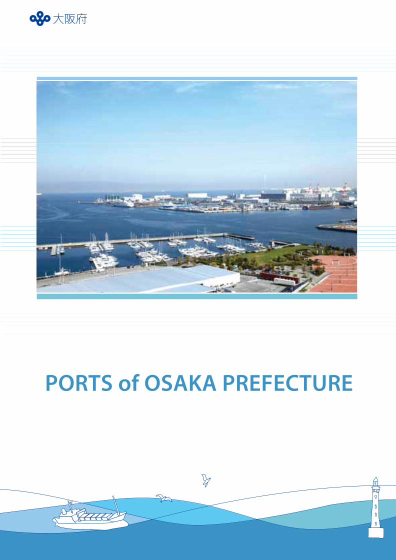
Port of Sakai-Semboku
Port of Hannan
Port of Nishiki Port of Izumisano
Port of Ozaki Port of Tannowa
Port of Fuke Port of Senshu21
The sea is our gateway to the world –
The sea teaches us that we are part of the world.
Osaka Bay – Japan’s marine gateway to the world –
is now undergoing numerous leading projects that
will contribute to the future development of Japan,
including Kansai International Airport Expansion
and the Phoenix Project.
Eight prefectural ports of various sizes, including
the Port of Sakai-Semboku (specially designated
major port) and the Port of Hannan (major port), are
located along the 70 kilometers of coastline
extending from the Yamato River in the north to the
Osaka-Wakayama prefectural border in the south.
Starting from Osaka Bay, Exchange for the 21st Century
From the World to Osaka, from Osaka to the Future
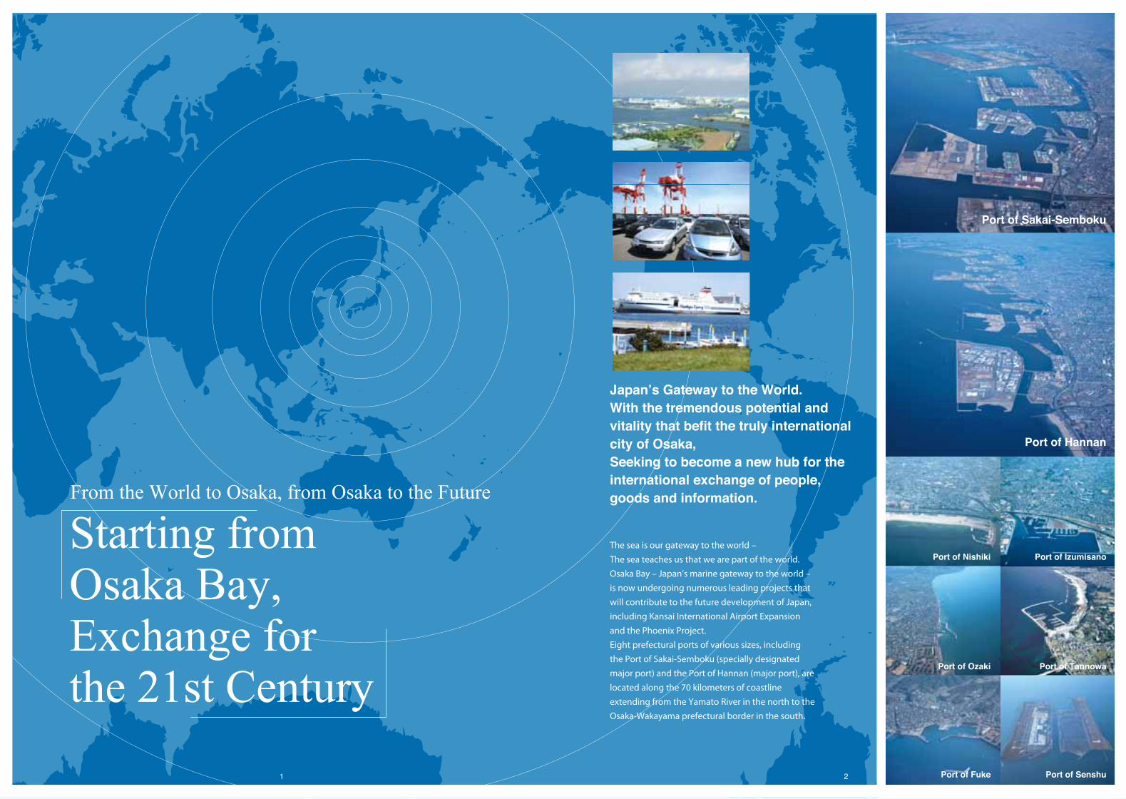
Japan’s Gateway to the World. With the tremendous potential and vitality that befit the truly international city of Osaka, Seeking to become a new hub for the international exchange of people, goods and information.
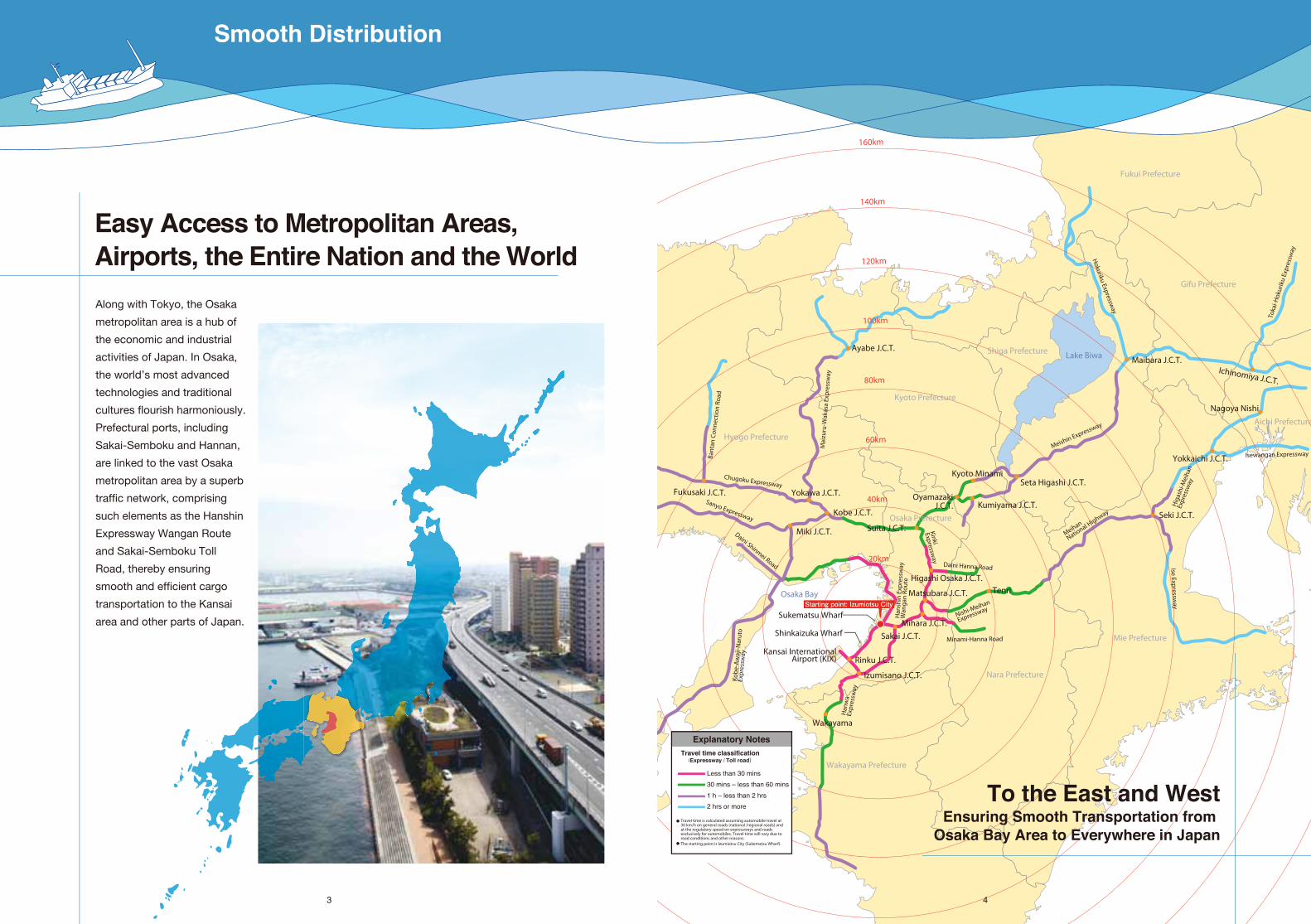
Easy Access to Metropolitan Areas, Airports, the Entire Nation and the World
Along with Tokyo, the Osaka
metropolitan area is a hub of
the economic and industrial
activities of Japan. In Osaka,
the world’s most advanced
technologies and traditional
cultures flourish harmoniously.
Prefectural ports, including
Sakai-Semboku and Hannan,
are linked to the vast Osaka
metropolitan area by a superb
traffic network, comprising
such elements as the Hanshin
Expressway Wangan Route
and Sakai-Semboku Toll
Road, thereby ensuring
smooth and efficient cargo
transportation to the Kansai
area and other parts of Japan.
Izumisano J.C.T.
Wakayama
Sakai J.C.T.Mihara J.C.T.
Sukematsu Wharf
Kansai InternationalAirport (KIX)
Shinkaizuka Wharf
Matsubara J.C.T. TenriHigashi Osaka J.C.T.
Suita J.C.T.
Kumiyama J.C.T.
Seta Higashi J.C.T.
OyamazakiJ.C.T.
Kyoto Minami
Kobe J.C.T.
Miki J.C.T.
Yokawa J.C.T.
Ayabe J.C.T.
Fukusaki J.C.T.Sanyo Expressway
Daini Shinmei Road
Chugoku Expressway
Meishin Expressway
Meihan
National H
ighway
Nishi-Meihan
Expressway
Minami-Hanna Road
Daini Hanna Road
Han
shin
Exp
ress
way
W
anga
n Ro
ute
Kinki Expressw
ay
Isewangan ExpresswayBant
an C
onne
ctio
n Ro
ad
Mai
zuru
-Wak
asa
Expr
essw
ay
Hokuriku Expressw
ay
Toka
i-Hok
urik
u Ex
pres
sway
Hig
ashi
-Mei
han
Expr
essw
ay
Ise Expressway
Kobe
-Aw
aji-N
arut
oEx
pres
sway
Han
wa
Expr
essw
ay
Rinku J.C.T.
Maibara J.C.T.
Seki J.C.T.
Yokkaichi J.C.T.
Ichinomiya J.C.T.
Starting point: Izumiotsu City
Osaka Prefecture
Hyogo Prefecture
Kyoto Prefecture
Shiga Prefecture Lake Biwa
Osaka Bay
Nara Prefecture
Wakayama Prefecture
Mie Prefecture
Gifu Prefecture
Aichi Prefecture
Fukui Prefecture
160km
140km
120km
100km
80km
60km
40km
20km
Less than 30 mins
30 mins – less than 60 mins
1 h – less than 2 hrs
2 hrs or more
Explanatory NotesTravel time classification
(Expressway / Toll road)
Travel time is calculated assuming automobile travel at 30 km/h on general roads (national /regional roads) and at the regulatory speed on expressways and roads exclusively for automobiles. Travel time will vary due to road conditions and other reasons.The starting point is Izumiotsu City (Sukematsu Wharf).
4
To the East and WestEnsuring Smooth Transportation from
Osaka Bay Area to Everywhere in Japan
3
Nagoya Nishi
Smooth Distribution
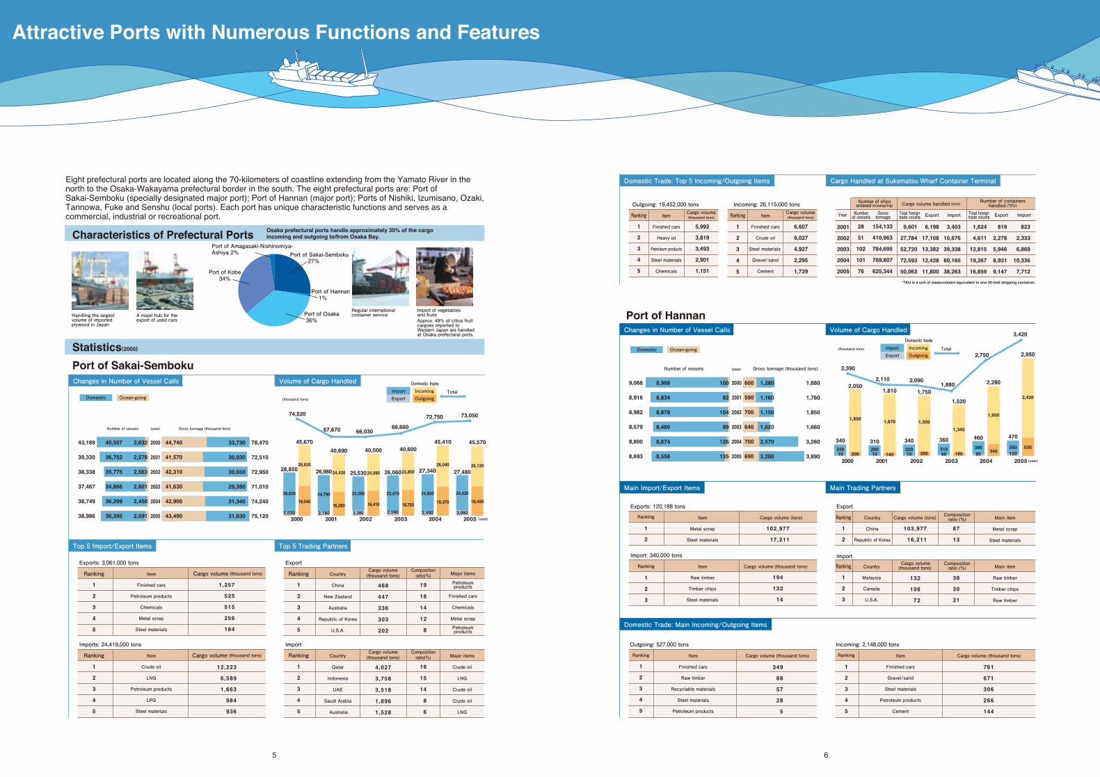
Eight prefectural ports are located along the 70-kilometers of coastline extending from the Yamato River in the north to the Osaka-Wakayama prefectural border in the south. The eight prefectural ports are: Port of Sakai-Semboku (specially designated major port); Port of Hannan (major port); Ports of Nishiki, Izumisano, Ozaki, Tannowa, Fuke and Senshu (local ports). Each port has unique characteristic functions and serves as a commercial, industrial or recreational port.
5 6
Characteristics of Prefectural Ports
Statistics(2005)
Port of Sakai-Semboku
Port of Osaka 36%
Port of Amagasaki-Nishinomiya-Ashiya 2%
Port of Hannan 1%
Port of Kobe34%
Port of Sakai-Semboku 27%
Handling the largest volume of importedplywood in Japan
A major hub for theexport of used cars
Import of vegetablesand fruits
Regular internationalcontainer service
Changes in Number of Vessel Calls Volume of Cargo Handled
Top 5 Import/Export Items Top 5 Trading Partners
Number of vessels (year)
(year)
(year)
Gross tonnage (thousand tons)
43,189
39,330
38,338
37,467
38,749
38,986
40,557
36,752
35,775
34,866
36,299
36,395
2,632
2,578
2,563
2,601
2,450
2,591
44,740
41,570
42,310
41,630
42,900
43,490
28,850
26,820
2,030
45,670
26,630
19,040
25,530
23,260
2,280
40,500
24,090
16,410
26,060
23,470
2,590
40,600
23,850
16,750
27,340
24,850
2,490
45,410
26,040
19,370
27,480
24,420
3,060
45,570
26,120
19,450
26,980
24,790
2,180
40,690
24,420
16,280
74,520
67,670 66,03066,660
72,750 73,050
78,470
72,510
72,950
71,010
74,240
75,120
33,730
30,930
30,650
29,380
31,340
31,630
2000
2001
2002
2003
2004
2005
Exports: 3,061,000 tons
Domestic Ocean-going
2000 2001 2002 2003 2004 2005
Number of vessels Gross tonnage (thousand tons)
9,068
8,916
8,982
8,579
8,800
8,693
8,968
8,834
8,878
8,480
8,674
8,558
100
82
104
99
126
135
600
590
700
640
700
690
340
33010
2,050
1,850
200
340
32010
1,750
1,550
200
360
31060
1,520
1,340
180
460
39080
2,280
1,950
340
470
350120
2,950
2,420
53031029010
1,810
1,670
140
2,390
2,110 2,0901,880
2,750
3,420
1,880
1,760
1,850
1,660
3,260
3,890
1,280
1,160
1,150
1,020
2,570
3,200
Port of HannanChanges in Number of Vessel Calls Volume of Cargo Handled
Main Import/Export Items Main Trading Partners
Ranking
1
2
3
4
5
Item
Finished cars
Petroleum products
Chemicals
Metal scrap
Steel materials
1,257
525
515
256
184
Cargo volume (thousand tons)
Exports: 120,188 tons
Ranking
1
2
Item
Metal scrap
Steel materials
102,977
17,211
Cargo volume (tons)
Import: 340,000 tons
Ranking
1
2
3
Item
Raw timber
Timber chips
Steel materials
194
132
14
Cargo volume (thousand tons)
Export
Import
Ranking
1
2
Country
China
Republic of Korea
103,977
16,211
Cargo volume (tons)
Ranking
1
2
3
Country
Malaysia
Canada
U.S.A.
87
13
38
30
21
Main item
Metal scrap
Steel materials
Main item
Raw timber
Timber chips
Raw timber
132
106
72
Cargo volume(thousand tons)
Imports: 24,419,000 tons
Ranking
1
2
3
4
5
Item
Crude oil
LNG
Petroleum products
LPG
Steel materials
12,223
6,589
1,663
984
936
Cargo volume (thousand tons)
Export
Import
Country
China
New Zealand
Australia
Republic of Korea
U.S.A.
19
18
14
12
8 Petroleumproducts
Metal scrap
Chemicals
Finished cars
Petroleumproducts
Major items
468
447
336
303
202
Cargo volume(thousand tons)
Ranking
1
2
3
4
5
Ranking
1
2
3
4
5
Country
Qatar
Indonesia
UAE
Saudi Arabia
Australia
16
15
14
8
6
Major items
Crude oil
LNG
Crude oil
Crude oil
LNG
4,027
3,758
3,518
1,896
1,528
Outgoing: 527,000 tons
Ranking
1
2
3
4
5
Item
Finished cars
Raw timber
Recyclable materials
Steel materials
Petroleum products
349
88
57
28
5
Cargo volume (thousand tons)
Incoming: 2,148,000 tons
Ranking
1
2
3
4
5
Item
Finished cars
Gravel/sand
Steel materials
Petroleum products
Cement
761
671
306
266
144
Cargo volume (thousand tons)
Domestic Trade: Top 5 Incoming/Outgoing Items Cargo Handled at Sukematsu Wharf Container Terminal
Outgoing: 19,452,000 tons
Ranking
1
2
3
4
5
Item
Finished cars
Heavy oil
Petroleum products
Steel materials
Chemicals
5,992
3,819
3,493
2,901
1,151
Incoming: 26,115,000 tons
*TEU is a unit of measurement equivalent to one 20-foot shipping container.
823
2,333
6,869
10,336
7,712
819
2,278
5,946
8,931
9,147
1,624
4,611
12,815
19,267
16,859
3,403
10,676
39,338
60,165
38,263
6,198
17,108
13,382
12,428
11,800
Ranking
1
2
3
4
5
2001
2002
2003
2004
2005
Item
Finished cars
Crude oil
Steel materials
Gravel/sand
Cement
28
51
102
101
76
Total foreigntrade volume
9,601
27,784
52,720
72,593
50,063
Export Import Total foreigntrade volume Export Import
Number of shipsentered (oceangoing) Cargo volume handled (tons) Number of containers
handled (TEU)
154,133
410,963
784,695
769,807
625,344
6,607
6,027
4,927
2,295
1,729
Cargo volume(thousand tons)
Cargo volume(thousand tons)
Domestic Trade: Main Incoming/Outgoing Items
IncomingOutgoing
ImportExport
Total
Domestic Ocean-going
Compositionratio(%)
Cargo volume(thousand tons)
Compositionratio(%)
Compositionratio (%)
Compositionratio (%)
Numberof vesselsYear Gross
tonnage
Approx. 49% of citrus fruit cargoes imported to Western Japan are handled at Osaka prefectural ports.
2000
2001
2002
2003
2004
20052000 2001 2002 2003 2004 2005
(year)
Osaka prefectural ports handle approximately 30% of the cargo incoming and outgoing to/from Osaka Bay.
Domestic trade
(thousand tons)
(thousand tons) IncomingOutgoing
ImportExport
Total
Domestic trade
Attractive Ports with Numerous Functions and Features
7 8
あすぽーと21
Create amenity-rich waterfront environment valued by residents.
Ensure land and maritime safety.
Develop future-oriented ports to meet the needs of the 21st century.
Amenity Port
Safety Port
User Fr iendly Port
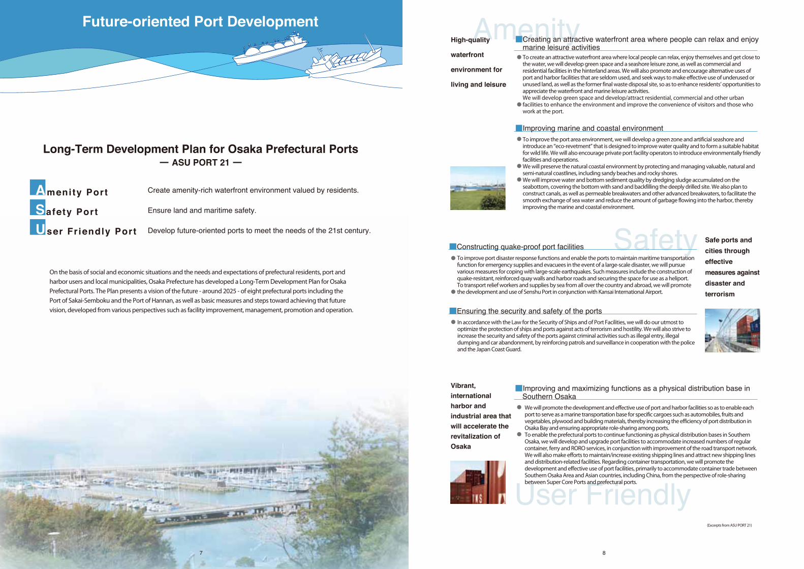
On the basis of social and economic situations and the needs and expectations of prefectural residents, port and harbor users and local municipalities, Osaka Prefecture has developed a Long-Term Development Plan for Osaka Prefectural Ports. The Plan presents a vision of the future - around 2025 - of eight prefectural ports including the Port of Sakai-Semboku and the Port of Hannan, as well as basic measures and steps toward achieving that future vision, developed from various perspectives such as facility improvement, management, promotion and operation.
Long-Term Development Plan for Osaka Prefectural PortsASU PORT 21
(Excerpts from ASU PORT 21)
AmenityTo create an attractive waterfront area where local people can relax, enjoy themselves and get close to the water, we will develop green space and a seashore leisure zone, as well as commercial and residential facilities in the hinterland areas. We will also promote and encourage alternative uses of port and harbor facilities that are seldom used, and seek ways to make effective use of underused or unused land, as well as the former final waste disposal site, so as to enhance residents’ opportunities to appreciate the waterfront and marine leisure activities.We will develop green space and develop/attract residential, commercial and other urban facilities to enhance the environment and improve the convenience of visitors and those who work at the port.
To improve the port area environment, we will develop a green zone and artificial seashore and introduce an “eco-revetment” that is designed to improve water quality and to form a suitable habitat for wild life. We will also encourage private port facility operators to introduce environmentally friendly facilities and operations.We will preserve the natural coastal environment by protecting and managing valuable, natural and semi-natural coastlines, including sandy beaches and rocky shores.We will improve water and bottom sediment quality by dredging sludge accumulated on the seabottom, covering the bottom with sand and backfilling the deeply drilled site. We also plan to construct canals, as well as permeable breakwaters and other advanced breakwaters, to facilitate the smooth exchange of sea water and reduce the amount of garbage flowing into the harbor, thereby improving the marine and coastal environment.
●
●
●
●
●
■Creating an attractive waterfront area where people can relax and enjoy marine leisure activities
■Improving marine and coastal environment
High-quality
waterfront
environment for
living and leisure
To improve port disaster response functions and enable the ports to maintain maritime transportation function for emergency supplies and evacuees in the event of a large-scale disaster, we will pursue various measures for coping with large-scale earthquakes. Such measures include the construction of quake-resistant, reinforced quay walls and harbor roads and securing the space for use as a heliport.To transport relief workers and supplies by sea from all over the country and abroad, we will promote the development and use of Senshu Port in conjunction with Kansai International Airport.
In accordance with the Law for the Security of Ships and of Port Facilities, we will do our utmost to optimize the protection of ships and ports against acts of terrorism and hostility. We will also strive to increase the security and safety of the ports against criminal activities such as illegal entry, illegal dumping and car abandonment, by reinforcing patrols and surveillance in cooperation with the police and the Japan Coast Guard.
Safety●
●
●
■Constructing quake-proof port facilities
■Ensuring the security and safety of the ports
Safe ports and
cities through
effective
measures against
disaster and
terrorism
User Friendly
We will promote the development and effective use of port and harbor facilities so as to enable each port to serve as a marine transportation base for specific cargoes such as automobiles, fruits and vegetables, plywood and building materials, thereby increasing the efficiency of port distribution in Osaka Bay and ensuring appropriate role-sharing among ports.To enable the prefectural ports to continue functioning as physical distribution bases in Southern Osaka, we will develop and upgrade port facilities to accommodate increased numbers of regular container, ferry and RORO services, in conjunction with improvement of the road transport network. We will also make efforts to maintain/increase existing shipping lines and attract new shipping lines and distribution-related facilities. Regarding container transportation, we will promote the development and effective use of port facilities, primarily to accommodate container trade between Southern Osaka Area and Asian countries, including China, from the perspective of role-sharing between Super Core Ports and prefectural ports.
●
●
■Improving and maximizing functions as a physical distribution base in Southern Osaka
Vibrant,
international
harbor and
industrial area that
will accelerate the
revitalization of
Osaka
Future-oriented Port Development
G
10
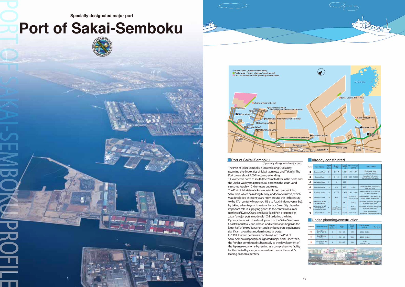
Port of Sakai-SembokuSpecially designated major port
■Port of Sakai-Semboku(Specially designated major port)
HagoromoStationHagoromoStationHagoromoStation
Hamadera-koen StationHamadera-koen StationHamadera-koen Station
Nankai LineNankai LineNankai Line
❾Shiomi Wharf❾Shiomi Wharf❾Shiomi Wharf
Hankai LineHankai LineHankai Line
N●Public wharf (Already constructed)Public wharf (Already constructed)●Public wharf (Under planning/construction)Public wharf (Under planning/construction)●Land reclamation (Under planning/construction)Land reclamation (Under planning/construction)
●Public wharf (Already constructed)●Public wharf (Under planning/construction)●Land reclamation (Under planning/construction)
●Sakai District No.Sakai District No. 7 ‒ No No. 3 3
●Shiomi Offshore DistrictShiomi Offshore District
●Sakai District No. 7 ‒ No. 3A
●Shiomi Offshore DistrictC
❸Hamadera Wharf❸Hamadera Wharf❸Hamadera Wharf
❻Sukematsu Wharf❻Sukematsu Wharf❻Sukematsu Wharf
❼Sukematsu Wharf Container Terminal❼Sukematsu Wharf Container Terminal❼Sukematsu Wharf Container Terminal
❽Sukematsu Wharf Multipurpose International Terminal❽Sukematsu Wharf Multipurpose International Terminal❽Sukematsu Wharf Multipurpose International Terminal
❷Ohama Wharf❷Ohama Wharf❷Ohama Wharf❺Komatsu Wharf❺Komatsu Wharf❺Komatsu Wharf
❻Sukematsu Wharf❻Sukematsu Wharf❻Sukematsu Wharf
❶Shiohama Wharf❶Shiohama Wharf❶Shiohama Wharf
Prefectural Road Sakai-Hannan Route
Prefectural Road Sakai-Hannan Route
Prefectural Road Sakai-Hannan RouteIzumiotsuStationIzumiotsuStationIzumiotsuStation
Hanshin Expressway Wangan RouteHanshin Expressway Wangan RouteHanshin Expressway Wangan Route
Hamadera-ekimaeStation
Hamadera-ekimaeStation
Hamadera-ekimaeStation
●Sakai DistricSakai District No No. 2 2●Sakai District No. 2B
SakaiStationSakaiStationSakaiStation
TakashinohamaStation
TakashinohamaStation
TakashinohamaStation
❹Matsunohama Wharf❹Matsunohama Wharf❹Matsunohama Wharf
Osaka BayOsaka BayOsaka Bay
■Already constructed
■Under planning/construction
The Port of Sakai-Semboku is located along Osaka Bay, spanning the three cities of Sakai, Izumiotsu and Takaishi. The Port covers about 9,000 hectares, extending 14 kilometers north to south (the Yamato River in the north and the Osaka-Wakayama prefectural border in the south), and stretches roughly 10 kilometers out to sea. The Port of Sakai-Semboku was established by combining Sakai Port, which has a long history, and Semboku Port, which was developed in recent years. From around the 15th century to the 17th century (Muromachi Era to Azuchi-Momoyama Era), by taking advantage of its natural harbor, Sakai City played an important role in supplying goods to the central consumer markets of Kyoto, Osaka and Nara; Sakai Port prospered as Japan’s major port in trade with China during the Ming Dynasty. Later, with the development of the Sakai-Semboku Coastal Industrial Zone, whose land reclamation began in the latter half of 1950s, Sakai Port and Semboku Port experienced significant growth as modern industrial ports.In 1969, the two ports were combined into the Port of Sakai-Semboku (specially designated major port). Since then, the Port has contributed substantially to the development of the Japanese economy by serving as a comprehensive facility for the Osaka Bay area, now considered one of the world’s leading economic centers.
Number
❶
❷
❸
❹
❺
❻
❼
❽
❾
Name of DistrictNumberof
Berths
Shiohama Wharf
Ohama Wharf
Hamadera Wharf
Matsunohama Wharf
Komatsu Wharf
Sukematsu Wharf
Sukematsu WharfContainer Terminal
Sukematsu WharfMultipurpose
InternationalTerminal
Shiomi Wharf
6
12
1
10
15
19
2
1
23
Depth (m)
2.5~7
3~10
4
5.5
4~7.5
4~9
12
14
4~12
OverallLength (m)
Ship Tonnage (DWT)
500~4,000
500~15,000
2,000
500~5,000
500~10,000Ferry: 15,000 (GT)
30,000
50,000(30,000)
500~30,000
Chemicals, steelmaterials, gravel
Vegetables/fruit, gravel,cement, paper/pulp, glass
Steel materials, metal scrap,synthetic resin
Steel materials, finished cars,coke, wood products
Steel materials, cars, paper/pulp,metal scrap, timber chips
Recyclable materials, daily goods,synthetic resin, cars
Recyclable materials, daily goods,synthetic resin, cars
Gravel, finished cars,wood products,steel materials
1,101
1,314
550
900
2,480
2,750
480
300
3,510
Major cargos
(water depth of 12min provisional service)
Sakai DistrictNo. 7 ‒ No. 3
Sakai DistrictNo. 2
Shiomi OffshoreDistrict
4
2
4
7.5~12
7.5~10
7.5~13
630
300
940
5,000~30,000
5,000~12,000
5,00025,000~65,600(GT)
Remarks
●
●
●C
B
A
Number Name of DistrictNumberof
BerthsDepth (m)
OverallLength (m)
Ship Tonnage (DWT)
11 12
●Sakai-Semboku●Sakai-Semboku●Sakai-Semboku
●Shanghai●Shanghai●Shanghai
Land-Use Plan Map
Auto auction venue
■Sakai-Semboku Port Multipurpose International Terminal
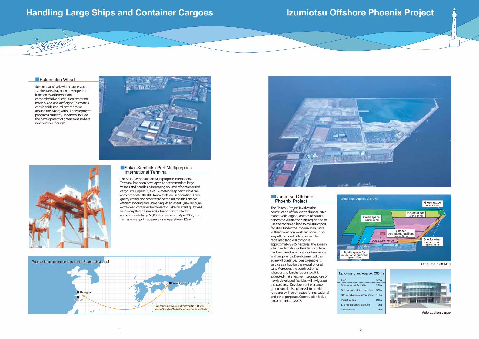
The Sakai-Semboku Port Multipurpose International Terminal has been developed to accommodate large vessels and handle an increasing volume of containerized cargo. At Quay No. 8, two 12-meter-deep berths that can accommodate 30,000- ton vessels, are in operation. Three gantry cranes and other state-of-the-art facilities enable efficient loading and unloading. At adjacent Quay No. 9, an extra-deep container berth (earthquake-resistant quay wall, with a depth of 14 meters) is being constructed to accommodate large 50,000-ton vessels. In April 2006, the Terminal was put into provisional operation (-12m).
■Sukematsu Wharf
Sukematsu Wharf, which covers about 120 hectares, has been developed to function as an international comprehensive distribution center for marine, land and air freight. To create a comfortable natural environment around the wharf, various development programs currently underway include the development of green zones where wild birds will flourish.
■Izumiotsu Offshore Phoenix ProjectThe Phoenix Project involves the construction of final waste disposal sites to deal with large quantities of wastes generated within the Kinki region and to use the reclaimed land to construct port facilities. Under the Phoenix Plan, since 2004 reclamation work has been under way off the coast of Izumiotsu. The reclaimed land will comprise approximately 205 hectares. The zone in which reclamation is thus far completed has been used as an auto auction venue and cargo yards. Development of this zone will continue, so as to enable its service as a hub for the export of used cars. Moreover, the construction of wharves and berths is planned. It is expected that effective, integrated use of newly developed facilities will invigorate the port area. Development of a large green zone is also planned, to provide residents with open space for recreational and other purposes. Construction is due to commence in 2007.
Regular international container line [Shanghai/Ningbo]Regular international container line [Shanghai/Ningbo]Regular international container line [Shanghai/Ningbo]
Green space (approx. 65 ha)
Gross area: Approx. 205.0 ha
Auto auction venue
Site forport-related facilities
(approx. 52 ha)
●Ningbo●
Ningbo●
Ningbo
・One sailing per week (Sukematsu No.8 Quay)・Ningbo-Shanghai-Osaka-Kobe-Sakai Semboku-Ningbo
Industrial site(approx. 34 ha)
Site for wharfconstruction(approx. 23 ha)
Public space forrecreational purposes
(approx. 16 ha)
Green space(approx. 7 ha)
Handling Large Ships and Container Cargoes Izumiotsu Offshore Phoenix Project
Land-use plan: Approx. 205 ha
Use Area
Site for wharf facilities 23ha
Site for port-related facilities 52ha
Site for public recreational space 16ha
Industrial site 34ha
Site for transport facilities 9ha
Green space 72ha

Rinkai Industrial Zone
13 14
■Shiomi Wharf
Shiomi Wharf, with storage sheds, warehouses and other modern port facilities, functions as a large wharf for foreign trade, handling 4.25 million tons of cargo in 2005. Quay No.5, located at the end of the wharf, has been developed exclusively to handle heavyweight cargoes; the 720-meter-long, 12-meter-deep berth can accommodate three large 30,000 D.W.T. ships at the same time. Shiomi Wharf, which is constructed to be earthquake-resistant, will serve as a supply base for emergency goods in the event of earthquake or other disaster. The offshore area is currently being reclaimed as part of the Phoenix Project.
■Shiohama Wharf
Shiohama Wharf, located at the north end of the Port of Sakai-Semboku, has been in operation since around 1944. The wharf has a 7-meter-deep berth and shallow draft berths.
■Ohama Wharf
Ohama Wharf has a 10-meter-deep berth and a shallow draft berth for smaller boats. At the end of the wharf is located the Sakai Fruit and Vegetable Center, the largest fruit and vegetable wholesale market in western Japan. The Center handles imported fruits and vegetables, mainly grapefruits, lemons, oranges and bananas, and contributes to the stable supply of vegetables and fruits at low prices. Approximately 49% of import cargoes of citrus fruits (grapefruits, lemons and oranges) in western Japan are handled at the Ohama Wharf.
■Hamadera Wharf
Hamadera Wharf, located at the inner end of the Hamadera Anchorage, functions as a tugboat base for the Port of Sakai-Semboku.
■Matsunohama Wharf
Matsunohama Wharf, located at the inner end of the Otsu Anchorage east of Komatsu Wharf, provides domestic cargo services. The wharf mainly handles steel materials.
■Komatsu Wharf
Komatsu Wharf is close to the downtown area and has good road access with Izumiotsu Ramp on Hanshin Expressway Wangan Route. Various port facilities, including private and prefectural sheds, are being developed.
Contributing to Regional Development
E
16
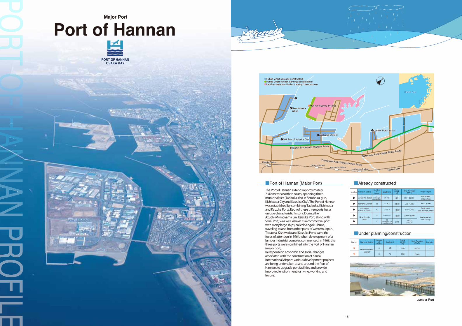
Port of HannanMajor Port
■Port of Hannan (Major Port)
The Port of Hannan extends approximately7 kilometers north to south, spanning three municipalities (Tadaoka-cho in Semboku-gun, Kishiwada City and Kaizuka City). The Port of Hannan was established by combining Tadaoka, Kishiwada and Kaizuka Ports. Each of these three ports has a unique characteristic history. During the Azuchi-Momoyama Era, Kaizuka Port, along with Sakai Port, was well known as a commercial port with many large ships, called Sengoku-bune, traveling to and from other parts of western Japan. Tadaoka, Kishiwada and Kaizuka Ports were the focus of attention in 1964, when development of a lumber industrial complex commenced. In 1968, the three ports were combined into the Port of Hannan (major port).In response to economic and social changes associated with the construction of Kansai International Airport, various development projects are being undertaken at and around the Port of Hannan, to upgrade port facilities and provide improved environment for living, working and leisure.
Lumber Port
PORT OF HANNANOSAKA BAY
■Already constructed
■Under planning/construction
Number
❶
❷
❸
❹
❺
Name of District
Lumber Port District
Jizohama District
Old Port of Kaizuka District
New KaizukaWharf
7
25
9
11
1
Depth (m)OverallLength(m)
1,264
3,270
1,502
1,230
240
Ship Tonnage(DWT)
Raw timber,timber chips
Sand, gravel
Sand, gravel,steel materials, wheat
Steel materials,metal scrap
(including 2mooring buoys)
Numberof
Berths
2~12
4~4.5
3~6.5
5.5~7.5
12
500~30,000
500~1,000
500~3,000
2,000~5,000
30,000(12,000)
Major cargos
(water depth of 10min provisional service)
Name of District
Hannan SecondDistrict
3
3
Depth (m)
12
7.5
720
390
OverallLength(m)
30,000
5,000
Remarks
Number
●
●
A
B
Numberof
BerthsShip Tonnage(DWT)
A
B
●●Public wharf (Already constructed)Public wharf (Already constructed)●Public wharf (Under planning/construction)Public wharf (Under planning/construction)●Land reclamation (Under planning/construction)Land reclamation (Under planning/construction)
●Public wharf (Already constructed)●Public wharf (Under planning/construction)●Land reclamation (Under planning/construction)
Prefectural Road Sakai-Hannan Route
Prefectural Road Sakai-Hannan Route
Prefectural Road Sakai-Hannan Route
Prefectural Road Os
aka Rinkai Route
Prefectural Road Os
aka Rinkai Route
Prefectural Road Os
aka Rinkai Route
Hanshin Expressway Wangan Route
Hanshin Expressway Wangan Route
Hanshin Expressway Wangan Route
Takojizo StationTakojizo StationTakojizo StationKishiwada StationKishiwada StationKishiwada Station
Izumi-omiya StationIzumi-omiya StationIzumi-omiya Station
❷Jizohama District❷Jizohama District❷Jizohama District
Nankai Line
Nankai Line
Nankai Line
N
●B
❹New Kaizuka Whaf❹New Kaizuka Whaf❹New Kaizuka Whaf
❺❺
❶Lumber Port District❶Lumber Port District❶Lumber Port District
●Hannan Second DistrictHannan Second District●Hannan Second DistrictA
❸Old Port of Kaizuka District❸Old Port of Kaizuka District❸Old Port of Kaizuka District
Kaizuka StationKaizuka StationKaizuka Station
Osaka BayOsaka BayOsaka Bay
17 18
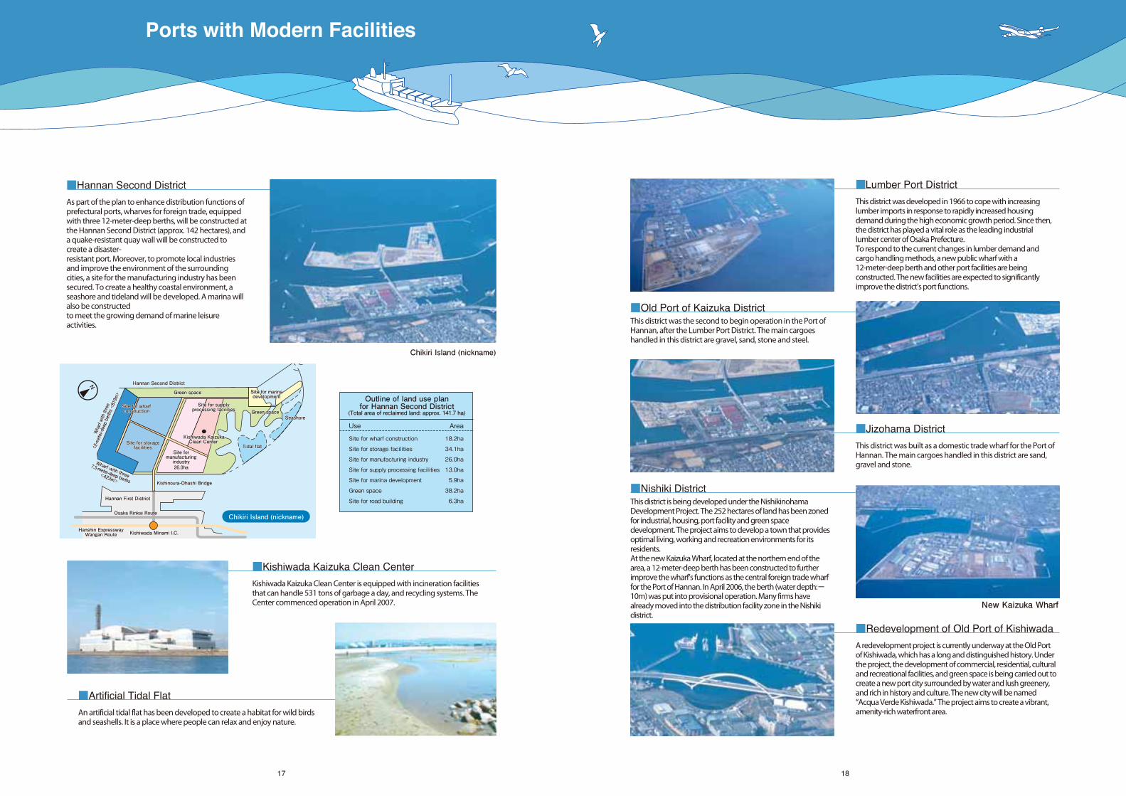
■Hannan Second District
As part of the plan to enhance distribution functions of prefectural ports, wharves for foreign trade, equipped with three 12-meter-deep berths, will be constructed at the Hannan Second District (approx. 142 hectares), and a quake-resistant quay wall will be constructed to create a disaster-resistant port. Moreover, to promote local industries and improve the environment of the surrounding cities, a site for the manufacturing industry has been secured. To create a healthy coastal environment, a seashore and tideland will be developed. A marina will also be constructedto meet the growing demand of marine leisure activities.
■Lumber Port District
This district was developed in 1966 to cope with increasing lumber imports in response to rapidly increased housing demand during the high economic growth period. Since then, the district has played a vital role as the leading industrial lumber center of Osaka Prefecture. To respond to the current changes in lumber demand and cargo handling methods, a new public wharf with a 12-meter-deep berth and other port facilities are being constructed. The new facilities are expected to significantly improve the district’s port functions.
■Jizohama District
This district was built as a domestic trade wharf for the Port of Hannan. The main cargoes handled in this district are sand, gravel and stone.
■Redevelopment of Old Port of Kishiwada
A redevelopment project is currently underway at the Old Port of Kishiwada, which has a long and distinguished history. Under the project, the development of commercial, residential, cultural and recreational facilities, and green space is being carried out to create a new port city surrounded by water and lush greenery, and rich in history and culture. The new city will be named “Acqua Verde Kishiwada.” The project aims to create a vibrant, amenity-rich waterfront area.
■Old Port of Kaizuka DistrictThis district was the second to begin operation in the Port of Hannan, after the Lumber Port District. The main cargoes handled in this district are gravel, sand, stone and steel.
■Nishiki DistrictThis district is being developed under the Nishikinohama Development Project. The 252 hectares of land has been zoned for industrial, housing, port facility and green space development. The project aims to develop a town that provides optimal living, working and recreation environments for its residents. At the new Kaizuka Wharf, located at the northern end of the area, a 12-meter-deep berth has been constructed to further improve the wharf’s functions as the central foreign trade wharf for the Port of Hannan. In April 2006, the berth (water depth:-10m) was put into provisional operation. Many firms have already moved into the distribution facility zone in the Nishiki district.
Chikiri Island (nickname)
New Kaizuka Wharf
Outline of land use planfor Hannan Second District
(Total area of reclaimed land: approx. 141.7 ha)
Use Area
Site for wharf construction 18.2ha
Site for storage facilities 34.1ha
Site for manufacturing industry 26.0ha
Site for supply processing facilities 13.0ha
Site for marina development 5.9ha
Green space 38.2ha
Site for road building 6.3ha
■Artificial Tidal Flat
An artificial tidal flat has been developed to create a habitat for wild birds and seashells. It is a place where people can relax and enjoy nature.
■Kishiwada Kaizuka Clean Center
Kishiwada Kaizuka Clean Center is equipped with incineration facilities that can handle 531 tons of garbage a day, and recycling systems. The Center commenced operation in April 2007.
Chikiri Island (nickname)
Kishinoura-Ohashi Bridge Kishinoura-Ohashi Bridge Kishinoura-Ohashi Bridge
Hannan First DistrictHannan First DistrictHannan First District
Osaka Rinkai RouteOsaka Rinkai RouteOsaka Rinkai Route
Hanshin ExpresswayWangan Route
Hanshin ExpresswayWangan Route
Hanshin ExpresswayWangan Route Kishiwada Minami I.C.Kishiwada Minami I.C.Kishiwada Minami I.C.
Tidal flatTidal flatTidal flat
SeashoreSeashoreSeashoreGreen spaceGreen spaceGreen space
Site formanufacturingindustry
Site formanufacturingindustry
Site formanufacturingindustry26.0ha26.0ha26.0ha
Wharf with three
12-meter-deep berths <819m>
Wharf with three
12-meter-deep berths <819m>
Wharf with three
12-meter-deep berths <819m>
Wharf with three
7.5-meter-deep berths<423m>
Wharf with three
7.5-meter-deep berths<423m>
Wharf with three
7.5-meter-deep berths<423m>
Green spaceGreen spaceGreen space
Site for wharfconstructionSite for wharfconstructionSite for wharfconstruction
Kishiwada KaizukaClean Center
Kishiwada KaizukaClean Center
Kishiwada KaizukaClean Center
Hannan Second DistrictHannan Second DistrictHannan Second District
Site for storagefacilities
Site for storagefacilities
Site for storagefacilities
Site for supplyprocessing facilitiesSite for supply
processing facilitiesSite for supply
processing facilities
Site for marinadevelopmentSite for marinadevelopmentSite for marinadevelopment
N
Ports with Modern Facilities
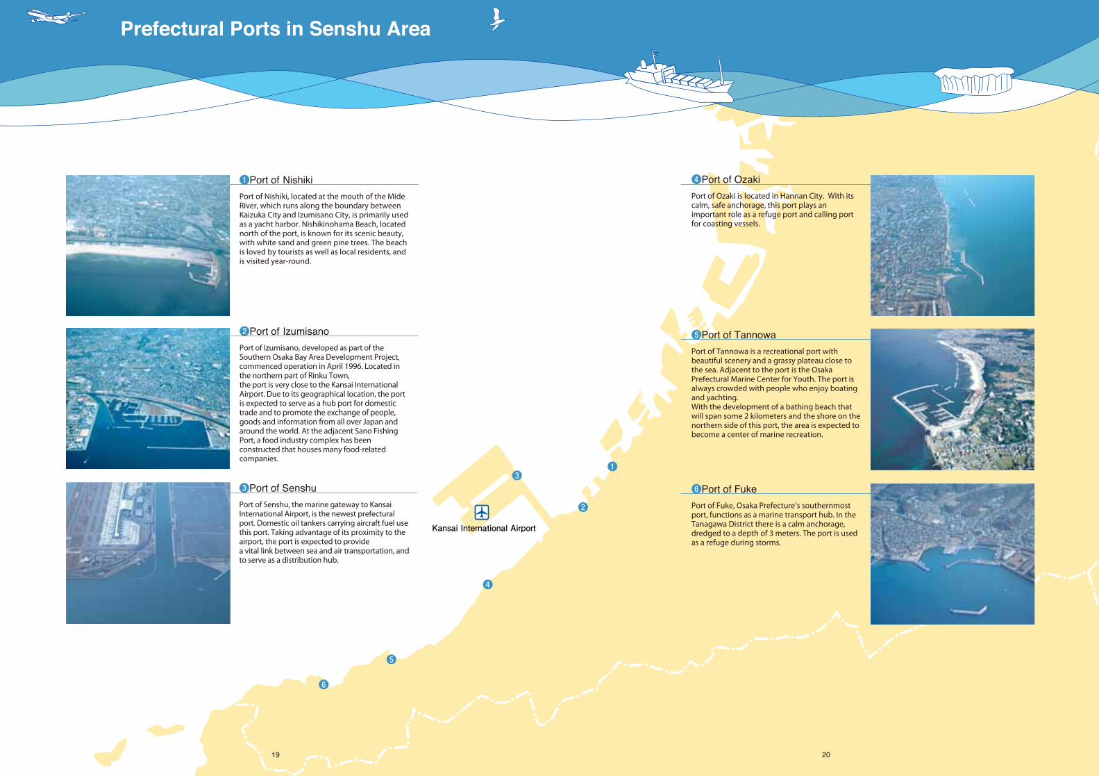
❶
❷
❸
❹
❺
❻
Kansai International Airport
19 20
❻Port of Fuke
Port of Fuke, Osaka Prefecture’s southernmost port, functions as a marine transport hub. In the Tanagawa District there is a calm anchorage, dredged to a depth of 3 meters. The port is used as a refuge during storms.
❺Port of Tannowa
Port of Tannowa is a recreational port with beautiful scenery and a grassy plateau close to the sea. Adjacent to the port is the Osaka Prefectural Marine Center for Youth. The port is always crowded with people who enjoy boating and yachting. With the development of a bathing beach that will span some 2 kilometers and the shore on the northern side of this port, the area is expected to become a center of marine recreation.
❹Port of Ozaki
Port of Ozaki is located in Hannan City. With its calm, safe anchorage, this port plays an important role as a refuge port and calling port for coasting vessels.
❷Port of Izumisano
Port of Izumisano, developed as part of the Southern Osaka Bay Area Development Project, commenced operation in April 1996. Located in the northern part of Rinku Town,the port is very close to the Kansai International Airport. Due to its geographical location, the port is expected to serve as a hub port for domestic trade and to promote the exchange of people, goods and information from all over Japan and around the world. At the adjacent Sano Fishing Port, a food industry complex has been constructed that houses many food-related companies.
❶Port of Nishiki
Port of Nishiki, located at the mouth of the Mide River, which runs along the boundary between Kaizuka City and Izumisano City, is primarily used as a yacht harbor. Nishikinohama Beach, located north of the port, is known for its scenic beauty, with white sand and green pine trees. The beach is loved by tourists as well as local residents, and is visited year-round.
❸Port of Senshu
Port of Senshu, the marine gateway to Kansai International Airport, is the newest prefectural port. Domestic oil tankers carrying aircraft fuel use this port. Taking advantage of its proximity to the airport, the port is expected to providea vital link between sea and air transportation, and to serve as a distribution hub.
Prefectural Ports in Senshu Area
2221
(Sakai) Kenmin-sen (a Japanese envoy ship to Ming Dynasty China) arrived for the first time at the Port of Sakai. The port subsequently served as a center of trade with China.
(Kaizuka) Flourished as a commercial port, taking advantage of the foreign policy promoted by Hideyoshi Toyotomi.
(Kishiwada) Fishing boats were allowed easier access to the port, under the order of feudal lord Okabe.
(Sakai) The southern wharf was extended, and a western-style permanent white lighthouse was built.
(Kishiwada) Became a designated port of the Ministry of Domestic Affairs.
(Fuke) Became a designated port of the Ministry of Transport.
(Tannowa) Was designated a local port.(Fuke) Was designated a local port and came under management of Osaka Prefectural Government.
(Sakai) Was designated a local port and came under management of Osaka Prefectural Government.(Ozaki) Came under management of Osaka Prefectural Government.
(Tadaoka) Came under management of Osaka Prefectural Government.(Nishiki) Was designated a local port.
(Sakai) Was upgraded to a major port.
(Sakai) Was upgraded to a specially designated major port.(Semboku) Otsu Port was renamed Semboku Port.(Kaizuka) Came under management of Osaka Prefectural Government.
(Nishiki) Came under management of Osaka Prefectural Government.
Port facilities of Tadaoka, Kishiwada and Kaizuka put into service.Lumber industry complex completed.
Tadaoka, Kishiwada and Kaizuka Ports were combined into Port of Hannan (major port)
Sakai and Semboku Ports were combined into Port of Sakai-Semboku (specifically designated major port).
(Sakai-Semboku) The Great Izumiotsu Bridge completed.
(Sakai-Semboku) Hankyu Ferry commenced Izumiotsu-Kokura ferry service (present: Izumiotsu-Shin Moji).
(Sakai-Semboku) Port seal established. Port of Sakai-Semboku and Port of Lianyungang in Jiangsu Province, China signed a friendship port pact.
Osaka Port and Harbor Bureau established.
(Sakai-Semboku) Port of Sakai-Semboku and Tanjung Perak in East Java, Indonesia signed a sister port pact. (Izumisano) Approved as a harbor district.
(Sakai-Semboku) A plan for constructing an international integrated distribution center in Semboku Sixth District was announced. (In the following year, the plan was named “Tri-Port Southern 21,” a name selected from among entries from the public.)Kishiwada Flood Gate commenced operation.
(Hannan) Port seal established.
“The 9th Marine Festival” was celebrated at Osaka prefectural ports.Port of Senshu approved as a harbor district.
(Sakai-Semboku) Container terminal opened at Sukematsu Wharf in Semboku Sixth District.
Port of Tannowa and surrounding area used as venues for Namihaya National Athletic Meet.
(Senshu) Expansion of the harbor area approved.
(Sakai-Semboku) The 2000 World Performing Arts Festival held in the Old Port of Sakai district.
Port development plan was revised.(Sakai-Semboku) Provisional service (-12m) commenced at the Multipurpose International Terminal (Quay No.9 (planned water depth 14m), Sukematsu Wharf, Semboku Sixth District).Sailing boat “Kaio-maru” called at the Port of Sakai-Semboku and was opened to the public.
PORT OF HANNANOSAKA BAY
■History
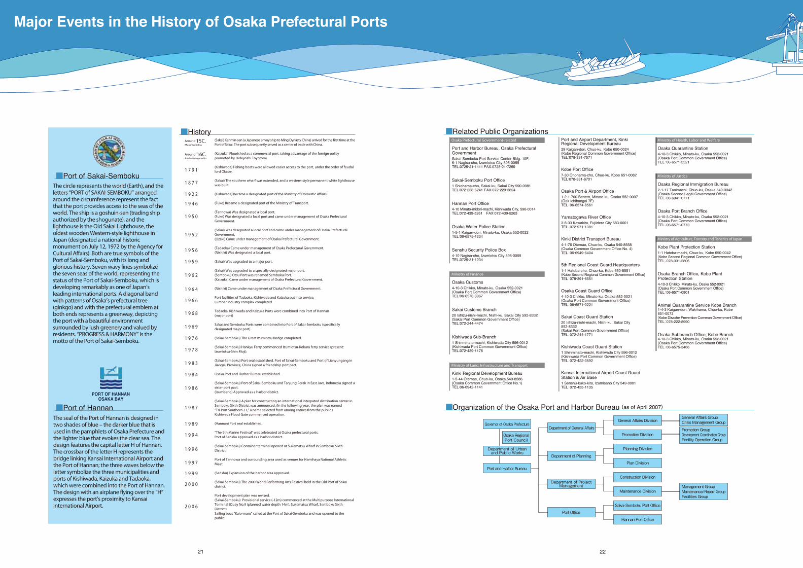
■Port of Sakai-SembokuThe circle represents the world (Earth), and the letters “PORT of SAKAI-SEMBOKU” arranged around the circumference represent the fact that the port provides access to the seas of the world. The ship is a goshuin-sen (trading ship authorized by the shogunate), and the lighthouse is the Old Sakai Lighthouse, the oldest wooden Western-style lighthouse in Japan (designated a national historic monument on July 12, 1972 by the Agency for Cultural Affairs). Both are true symbols of the Port of Sakai-Semboku, with its long and glorious history. Seven wavy lines symbolize the seven seas of the world, representing the status of the Port of Sakai-Semboku, which is developing remarkably as one of Japan’s leading international ports. A diagonal band with patterns of Osaka’s prefectural tree (ginkgo) and with the prefectural emblem at both ends represents a greenway, depicting the port with a beautiful environment surrounded by lush greenery and valued by residents. “PROGRESS & HARMONY” is the motto of the Port of Sakai-Semboku.
The seal of the Port of Hannan is designed in two shades of blue – the darker blue that is used in the pamphlets of Osaka Prefecture and the lighter blue that evokes the clear sea. The design features the capital letter H of Hannan. The crossbar of the letter H represents the bridge linking Kansai International Airport and the Port of Hannan; the three waves below the letter symbolize the three municipalities and ports of Kishiwada, Kaizuka and Tadaoka, which were combined into the Port of Hannan. The design with an airplane flying over the “H” expresses the port’s proximity to Kansai International Airport.
■Organization of the Osaka Port and Harbor Bureau (as of April 2007)
Governor of Osaka Prefecture
Department of Urbanand Public Works
Osaka RegionalPort Council
General Affairs GroupCrisis Management Group
Promotion GroupDevelopment Coordination GroupFacility Operation Group
Management GroupMaintenance/Repair GroupFacilities Group
General Affairs Division
Promotion Division
Planning Division
Plan Division
Construction Division
Sakai-Semboku Port Office
Hannan Port Office
Maintenance Division
Department of Planning
Department of General Affairs
Department of ProjectManagement
Port Office
Port and Harbor Bureau
Around 15C.Muromachi Era
Around 16C.Azuchi-Momoyama Era
1 7 9 1
1 8 7 7
1 9 2 2
1 9 4 6
1 9 5 0
1 9 5 2
1 9 5 6
1 9 5 9
1 9 6 2
1 9 6 4
1 9 6 6
1 9 6 8
1 9 6 9
1 9 7 6
1 9 7 8
1 9 8 3
1 9 8 4
1 9 8 6
1 9 8 7
1 9 8 9
1 9 9 4
1 9 9 6
1 9 9 7
1 9 9 9
2 0 0 0
2 0 0 6
■Port of Hannan
Major Events in the History of Osaka Prefectural Ports
■Related Public Organizations
Sakai-Semboku Port Office1 Shiohama-cho, Sakai-ku, Sakai City 590-0981TEL:072-238-5241 FAX:072-229-3824
Hannan Port Office4-10 Minato-midori-machi, Kishiwada City, 596-0014TEL:072-439-5261 FAX:072-439-5263
Osaka Water Police Station1-5-1 Kaigan-dori, Minato-ku, Osaka 552-0022TEL:06-6575-1234
Senshu Security Police Box4-10 Nagisa-cho, Izumiotsu City 595-0055TEL:0725-31-1234
Sakai Customs Branch20 Ishizu-nishi-machi, Nishi-ku, Sakai City 592-8332(Sakai Port Common Government Office)TEL:072-244-4474
Kishiwada Sub-Branch1 Shinminato-machi, Kishiwada City 596-0012(Kishiwada Port Common Government Office)TEL:072-439-1176
Port and Airport Department, Kinki Regional Development Bureau29 Kaigan-dori, Chuo-ku, Kobe 650-0024(Kobe Regional Common Government Office) TEL:078-391-7571
Kobe Port Office7-30 Onohama-cho, Chuo-ku, Kobe 651-0082TEL:078-331-6701
Osaka Port & Airport Office1-2-1-700 Benten, Minato-ku, Osaka 552-0007(Oak Ichibangai 7F)TEL:06-6574-8561
Yamatogawa River Office3-8-33 Kawakita, Fujiidera City 583-0001TEL:072-971-1381
Kinki District Transport Bureau4-1-76 Otemae, Chuo-ku, Osaka 540-8558(Osaka Common Government Office No. 4)TEL:06-6949-6404
5th Regional Coast Guard Headquarters1-1 Hatoba-cho, Chuo-ku, Kobe 650-8551(Kobe Second Regional Common Government Office)TEL:078-391-6551
Osaka Coast Guard Office4-10-3 Chikko, Minato-ku, Osaka 552-0021(Osaka Port Common Government Office)TEL:06-6571-0221
Sakai Coast Guard Station20 Ishizu-nishi-machi, Nishi-ku, Sakai City 592-8332(Sakai Port Common Government Office)TEL:072-244-1771
Kishiwada Coast Guard Station1 Shinminato-machi, Kishiwada City 596-0012(Kishiwada Port Common Government Office)TEL:072-422-3592
Kansai International Airport Coast Guard Station & Air Base1 Senshu-kuko-kita, Izumisano City 549-0001TEL:072-455-1135
Osaka Port Branch Office4-10-3 Chikko, Minato-ku, Osaka 552-0021(Osaka Port Common Government Office)TEL:06-6571-0773
Osaka Branch Office, Kobe Plant Protection Station4-10-3 Chikko, Minato-ku, Osaka 552-0021(Osaka Port Common Government Office)TEL:06-6571-0801
Animal Quarantine Service Kobe Branch1-4-3 Kaigan-dori, Wakihama, Chuo-ku, Kobe 651-0073(Kobe Disaster Prevention Common Government Office)TEL:078-222-8990
Osaka Subbranch Office, Kobe Branch 4-10-3 Chikko, Minato-ku, Osaka 552-0021(Osaka Port Common Government Office)TEL:06-6575-3466
Port and Harbor Bureau, Osaka Prefectural GovernmentSakai-Semboku Port Service Center Bldg. 10F,6-1 Nagisa-cho, Izumiotsu City 595-0055TEL:0725-21-1411 FAX:0725-21-7259
Osaka Prefectural Government-related
Kinki Regional Development Bureau1-5-44 Otemae, Chuo-ku, Osaka 540-8586(Osaka Common Government Office No.1) TEL:06-6942-1141
Ministry of Land, Infrastructure and Transport
Osaka Quarantine Station 4-10-3 Chikko, Minato-ku, Osaka 552-0021 (Osaka Port Common Government Office)TEL:06-6571-3521
Ministry of Health, Labor and Welfare
Osaka Regional Immigration Bureau 2-1-17 Tanimachi, Chuo-ku, Osaka 540-0042(Osaka Second Legal Government Office)TEL:06-6941-0771
Ministry of Justice
Kobe Plant Protection Station1-1 Hatoba-machi, Chuo-ku, Kobe 650-0042(Kobe Second Regional Common Government Office)TEL:078-331-2806
Ministry of Agriculture, Forestry and Fisheries of Japan
Osaka Customs4-10-3 Chikko, Minato-ku, Osaka 552-0021(Osaka Port Common Government Office)TEL:06-6576-3067
Ministry of Finance
Port and Harbor Bureau, Osaka Prefectural GovernmentDepartment of General Affairs / Department of Project Management6-1 Nagisa-cho, Izumiotsu City 595-0055
(Sakai-Semboku Port Service Center Bldg. 10F)
TEL: 0725-21-1411 FAX: 0725-21-7259
Department of Planning3-2-12 Otemae, Chuo-ku, Osaka 540-8570(Annex 7th floor)
TEL: 06-6941-0351 (Osaka Prefectural Government) FAX: 06-6941-0609
Produced in cooperation with: Osaka Prefecture Port and Harbor Association, Sakai-Semboku Port Promotion Council, Hannan Port Promotion Council
Osaka Prefectural Port Promotion Website: http://www.osakaprefports.jp/english/
PORTS of OSAKA PREFECTURE