Embed Size (px)
Citation preview

CASE STUDY: Townsville Cyclone, February 1940 By Mr Jeff Callaghan Retired Senior Severe Weather Forecaster, Bureau of Meteorology, Brisbane This tropical cyclone crossed the coast near Cardwell on 18 February 1940. The pressure at Cardwell dropped to 965 hPa. Huge seas left a trail of damage along the Strand in Townsville. Three open baths, a Memorial Park, and a seawall were destroyed. Flood waters driven back by storm surge isolated many parts of the city streets under 1 to 1.5 metres of water. A horse was found drowned with the rider missing. Seas were high up on residential land and fishermen at mouth of Ross River suffered much damage to boats, gear and houses. Waves 3 feet above flooring wrecked a house. The Bayview Hospital was damaged by wind. Giant fig trees were uprooted. Houses in the Stanton and Melton Hills suffered the most damage with roofing iron torn off and outhouses blown over. Trees were defoliated. Mean Sea Level Analyses The mean sea level analyses as the cyclone approached the coast is shown in Figure 1 while the analyses a day later while over land is shown in Figure 2. Note that the plotted winds still indicate gale force winds over inland areas a day after it made landfall. Impacts in other Centres Ingham:-‐ Police house, Church and 2 hotels unroofed and badly damaged. The Italian Club was lifted and carried 90 metres down the street. Nearly every building in the town was damaged. At the coast large slices of the Esplanade and the road were swept away. Tanks all over town moved hundreds of metres. Innisfail:-‐ A mother and child were injured by falling tree and another child was injured by the wind. Many trees were blown down. Tully:-‐ The wind blew down fences, outhouses and unroofed a sawmill. Palm Island:-‐ Two dormitories were unroofed and a concrete jail flattened. The Breakwater (hulk of ship) was torn to pieces by the sea. Waves caused tremendous changes to the sea front. Floods The heavy rains which were associated with the storm, caused extensive flooding in inland and coastal areas, the river basins most affected being those of the Burdekin, Thompson and Barcoo. Because of the length of the rivers and the duration of the rain, some floods did not occur at downstream stations until some days after the rain commenced, and Cloncurry, for example, was still flooded on the 1st of March. The effect of the floods was felt most in the coastal districts crossed by the storm, and particularly near Ayr, about 50 miles south of Townsville, where the waters of the Burdekin River flow into the sea.
Townsville Cyclone, February 1940 Data by J. Callaghan 22 September 2011
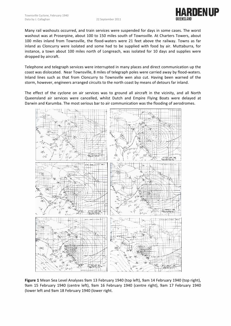
Many rail washouts occurred, and train services were suspended for days in some cases. The worst washout was at Proserpine, about 100 to 150 miles south of Townsville. At Charters Towers, about 100 miles inland from Townsville, the flood-‐waters were 21 feet above the railway. Towns as far inland as Cloncurry were isolated and some had to be supplied with food by air. Muttaburra, for instance, a town about 100 miles north of Longreach, was isolated for 10 days and supplies were dropped by aircraft. Telephone and telegraph services were interrupted in many places and direct communication up the coast was dislocated. Near Townsville, 8 miles of telegraph poles were carried away by flood-‐waters. Inland lines such as that from Cloncurry to Townsville wen also cut. Having been warned of the storm, however, engineers arranged circuits to the north coast by means of detours far inland. The effect of the cyclone on air services was to ground all aircraft in the vicinity, and all North Queensland air services were cancelled, whilst Dutch and Empire Flying Boats were delayed at Darwin and Karumba. The most serious bar to air communication was the flooding of aerodromes. Figure 1 Mean Sea Level Analyses 9am 13 February 1940 (top left), 9am 14 February 1940 (top right), 9am 15 February 1940 (centre left), 9am 16 February 1940 (centre right), 9am 17 February 1940 (lower left and 9am 18 February 1940 (lower right.

Townsville Cyclone, February 1940 Data by J. Callaghan 22 September 2011
Figure 2 Mean Sea Level Analyses 9am 19 February 1940.


![Conférences de Cécilia Dutter Etty 4 [3].pdfMicrosoft Word - Affiche Etty 4 .docx Created Date 20180303191025Z](https://img.pdfslide.tips/doc/110x75/5aba5fe67f8b9a297f8b9cbd/confrences-de-ccilia-etty-4-3pdfmicrosoft-word-affiche-etty-4-docx-created.jpg)


![Harden. Psalterium iuxta Hebraeos Hieronymi [S.P.C.K. Edition]. 1922](https://img.pdfslide.tips/doc/110x75/577cc8571a28aba711a28af5/harden-psalterium-iuxta-hebraeos-hieronymi-spck-edition-1922.jpg)