Embed Size (px)
Citation preview

MS3 WELSH JOINT EDUCATION COMMITTEE
£3.00 CYD-BWYLLGOR ADDYSG CYMRU
General Certificate of Education Tystysgrif Addysg Gyffredinol
Advanced Subsidiary/Advanced Uwch Gyfrannol/Uwch
MARKING SCHEMES
SUMMER 2004
GEOLOGY

INTRODUCTION
The marking schemes which follow were those used by the WJEC for the 2004 examination
in GCE Geology. They were finalised after detailed discussion at examiners' conferences by
all the examiners involved in the assessment. The conferences were held shortly after the
papers were taken so that reference could be made to the full range of candidates' responses,
with photocopied scripts forming the basis of discussion. The aim of the conferences was to
ensure that the marking schemes were interpreted and applied in the same way by all
examiners.
It is hoped that this information will be of assistance to centres but it is recognised at the
same time that, without the benefit of participation in the examiners' conferences, teachers
may have different views on certain matters of detail or interpretation.
The WJEC regrets that it cannot enter into any discussion or correspondence about these
marking schemes.

1
GL1
K/U A
Q.1 (a) Point A = arrow pointing to East/right
Point B = arrow pointing to West/left
Point C = arrow pointing to East/right
3 correct = 2 marks, 1 or 2 correct = 1 mark [2]
(b) (i) D within subducting lithospheric plate or at depth
within the continent. [1]
(ii) S in the lithosphere between the margins of the
rift valley. [1]
(iii) Compression of plates
Subduction of plate
Friction
Pressure build up/stress release [3]
(c) Youngest 1 4 3 2 Oldest = 2 marks [2]
or if not the above, can gain up to one mark max for:
2 as oldest or
1 as youngest or
3 older than 4
(d) Pillow lavas: Eruption into water
Rapid cooling
Formation of "skin" or glassy outer later.
Pillow shape as skin inflates with lava
Basaltic magma: Partial melting
Derived from mantle
Heated by rising mantle convection
Lower pressure/mantle decompression [4]
(Up to 3 max on either section in (d))
3
4
2
1
1
2
For 4 marks, must have both 'eruption into water' and 'partial melting'
reference.
7 6
Total 13

2
K/U A
Q.2 (a) Time taken for half of the parent atoms to decay to daughter
[1]
(b) (i) 5730 years (5100 - 6300) [1]
(ii) 12.5% [1]
(c) Proportion the same between atmosphere and living orgs
because exchange between org and environment.
Less in fossil than atmosphere due to decay of 14
C from
fossils/lack of replenishment from atmosphere. [3]
(Up to 2 marks max for comments related to either living
organisms or fossils)
(d) (i) Carboniferous too long ago
So many half lives have passed
that 14
C too small to measure [2]
(ii) No organic matter in a dyke
14
C only in organic matter [2]
(iii) Organic matter present
within the correct age range [2]
(e) Stating type of example e.g. dyke, unconformity, clast
Precise location for the example
Scale (in text or on diagram)
Quality of drawing/description
Evidence of appropriate conclusion or explanation of law of
included fragments/cross cutting
1
3
2
2
2
5
1
1
15 2
Total 17

3
K/U A
Q.3 (a) (i) Pyrite [1]
(ii) Replacement
Molecule by molecule of original calcium carbonate
shell. [2]
(b) (i) Cephalopod/Ammonoid/Goniatite [1]
(ii) Suture Line
Rounded saddle
Angular lobe
Simple/goniatitic or goniatite type
Become more complex over time [2]
(iii) Loose boulder may not have come from cliff face
Fossil P may be a derived fossil [2]
(c) (i) Shale [1]
(ii) Coal
Shale or Rock A
Sandstone [2]
3 correct = 2 marks, 2 correct = 1 mark
(iii) Grading within the sandstone bed is fining upwards.
Load cast/load and flame structure/convolute
structure correctly orientated as heavier sand
deposited on wet, finer sediment
Plant root fossil in situ, roots pointing downwards
[3]
1
2
1
2
1
2
2
3
9 5
Total 14

4
K/U A
Q.4 (a) Rounded/oval shape
2.5 – 3.5 km diameter [2]
(b) (i) Porphyritic
Phenocrysts or groundmass
Coarse
Crystalline or crystals
Phenocrysts/larger crystals up to 2cm
Groundmass/smaller crystals typically 0.5 cm
Random arrangement of crystals/interlocking/mosaic. [3]
Shape of crystals, e.g. euhedral phenocrysts, sub or
anhedral groundmass. [3]
(ii) Crystals in B all cooled at same rate /constant rate
C had 2 stage cooling
Magma cooled slowly during phenocryst formation
Magma moved higher in crust
Magma cooled quicker when groundmass formed. [3]
(iii) Rock B = Gabbro
Rock C = Granite [2]
(c) (i) Model 1 = Pluton
Model 2 = Sill or lava flow [2]
(ii) Model 1 because
Definition of discordant
Identifying that 2 is concordant or 1 is discordant
Rock B is coarse grained
Coarse grain size suggests formation within a pluton
rather than in a more rapidly cooling sill or lava
flow.
Edge of aureole outcrops on map, Fig 4a, and on
Model 1 only
Credit also given to other well reasoned points. [4]
1
1
3
3
1
1
1
1
4
12 6
Total 16

5
GL2a
Q Response Mark
1 (a) (i) Red-brown 1
(ii) Haematite 1
(b) Clasts
Averaging 1mm diameter
Well-sorted
Rounded (quartz)
More angular (feldspar)
1
1
1
1
1
5
(c) (i) 1 Use steel pin to scratch/break rock
2 Crumbles easily
1
1
1 Add few drops of water
2 Soaks in quickly
1
1
4
(ii) the porous nature or the ease of disintegration
suggests a low degree of cementation
1
1
2
(13)
2 (a) (i) L = pedical opening
M = hinge line
1
1
2
(ii) 1 Vertical line drawn through umbo at 90º to hinge
2 Fossil is not equivalve, but inequivalve
Fossil has a larger (pedical) valve and a smaller
(brachial) valve
2 max
1
2
(b) (i) Positive acid test
Rhombic cleavage
Calcite
1
1
1
3
(ii) Brachiopod = benthonic (shallow) and marine
(uniformitarianism)
Calcite = forms easily by organic/chemical ppt in warm
seas
X-beds show reversal = tidal current wave ripples =
shallow
1
1
1
3
(11)

6
Q Response Mark
3 (a) (i) "discordant" 1
(ii) Draw to scale
Non-parallel sides
Cooling joints or clasts in country rock
Chilled margin labelled
Baked margin labelled
1
1
1
1
1
5
(b) (i) Medium crystal size (2mm)
Mafic composition
1
1
2
(ii) Coarser crystals
Larger body takes longer to cool
1
1
2
(c)
1
1
1
1
1
1
6
(16)
4 (a) (i) Correct label 1
(ii) Weathered surface beneath
Basal Conglomerate in hollows
Included fragments above
Borings into lower rock group
Any 3
3
(iii) N-S axial plane traces correctly positioned and labelled Any 2 2
(b) (i) True = fault cross-cuts on Map 1
False = sinous outcrop on Map 1 suggests low angle of dip
False = older rocks must be on the upthrown side
1
1
1
3
(ii) Thrust 1
(10)
H
C
D
E
Faulting
Folding

7
Q Response Mark
5 Extend F2 to west (across small Valley on profile)
Correct movement on F2
Base of A (unconformity)
Correct cross-cut between unconformity and F2
H beneath unconformity
R S T plotted above F2 in thrust slice
Antiform correctly positioned and labelled in thrust slice
Synform correctly positioned and labelled in thrust slice
1
1
1
1
1
1
2 max
2 max
10
(10)

8
GL3
Questions Marks
1. (a) (i) A – decreases
B – increases (1) [1]
(ii) 1959 – 0 cm
1969 – + 20 cm (1)
20 cm/10 years = + 2cm/yr (1) [2]
(iii) C – little/no significant change in length (1)
C – both ends of survey line on same fault block (1)
B – crosses the fault/extension (1) [3]
3
(b) Arrows showing dextral strike slip (1)
D – shows extension over time (1) [2]
2
(c) Reduction in extension or compression along a survey line (1)
shows build up of stress (1)
Seismic gap (1)
Some move faster than others (1)
Thus increase chance of an earthquake (1)
(Max 2 marks) [2]
1
1
(d) One explained from:
groundwater levels/pressure
tilting/ground elevation
radon gas emissions
electromagnetic signals
electrical resistivity
animal behaviour
earthquake lights
changes in seismic activity
Other appropriate explained
(Max 3 marks) [3]
3
Total 13 Marks
4
9

9
Questions Marks
2. (a) Solid rock surface beneath drift (1)
(b) (i) Explosion/pressure-air gun/etc. (1)
(ii) 100m – Direct
200m – Refracted
(iii) Direct waves arrive first over short distances/
Refracted waves arrive first over longer distances (1)
Refracted waves travel further to reach geophone. (1)
As they have a greater velocity in solid rock than drift (1)
Solid rock more incompressible/rigid (1)
(Visa versa for direct)
(Max 3) [3]
1
2
(c) In Figure 2a – Rockhead linked on boreholes (1)
Showing valley at 60m (1) [2]
2
(d) Two of the following explained:
1. Porosity/permeability
Effect of water table/pressure explained
2. Structural weaknesses
(bedding/faults/cleavage/joints) explained
3. Rock competency
plastic deformation, etc.
4. Depth to rockhead
thickness of weak, unconsolidated drift in buried valley
Other suitable, must be GEOLOGICAL property
(Max 2 per property explained) [4]
2
2
Total 12 Marks
5
7

10
Questions Marks
3. (a) Describe how sites of potential slope failure can be monitored.
Mechanics of mapping, air photo-satellite imagery, surveying,
measurement strain, groundwater pressures described.
Instruments used.
Accept volcanic slope monitoring (Mt. St. Helens).
(Max. 10 marks)
(b) Explain the factors that can trigger or contribute to mass
movements or rock and soil.
Angle of slope:
Slopes above 35 degrees are often unstable (exception –
solifluction, etc.).
Friction is greater than forces of gravity.
Result = rockfall/slides, rotational slip, stumping.
Lithology/Load:
Shale, clay, etc. – are incompetent and will flow/slip under load
pressure and lubrication – rotational slip.
Sandstone/Limestone – joint patterns/bedding.
Crystalline igneous and metamorphic = strong but less stable if
cleavage present.
Weathering/Shrinkage and expansion:
Competent rock (granite) is reduced to clay – loses cohesion
between grains/joints density.
Physical/Chemical/Biological effects on rocks.
Groundwater/rainfall:
Acts as a lubricant to accelerate movement by reducing friction
between blocks/particles. Pore pressure, erosion.
Ground vibration:
Loss of friction/cohesion between grains and discontinuities.
Orientation of discontinuities:
Unstable friction angles.
KU A
Breadth v depth.
(Credit for examples and diagrams)
25
-
Total 25 Marks

11
Questions Marks
4. (a) Using one or more case studies, describe how two of the
following volcanic hazards have resumed in toss of life and
damage to property.
(i) Blast/explosion
Explosive index – Types: - Hawaiian – Ultra Plinian.
Lateral blast - e.g. Mt. St. Helens – heat, speed, force,
distance travelled.
Vertical blast – e.g. Pinatubo, Krakatoa.
Secondary effects -trees levelled, rivers blocked by debris, effect of bombs/ash, etc. tsunamis.
(Max. 7 plus 1. No case study – Max. 3 plus 1)
(ii) Mudflow/lahar
Reworked ash from volcano.
Hot, liquid.
Consistency of concrete.
Melted snow and torrential rain.
Lasts for years.
Difficult to predict.
E.g. Armero (Columbia)/Pinatubo, etc.
(Max. 7 plus 1. No case study – Max. 3 plus 1)
(iii) Volcanic gases
Variety – CO2, H2S, CO, SO
2, etc.
- contain fluorine, sulphur, chlorine – noxious.
Hot (1000C).
Effect on vegetation.
Not affecting buildings but kill people.
Lake overturn – Lake Nyos (Cameroon).
(Max. 7 plus 1. No case study – Max. 3 plus 1)
(iv) Lava flows
Hot, fluid (depending on composition and temperature).
Can be fast flowing (50km/hr) or slow, travel far (50km)
or not.
Easy to avoid for people/not for property.
Causes fire and loss of property.
Can kill in rare cases (very fluid lava).
E.g. Nyiragongo Congo, Etna, etc.
(Max. 7 plus 1. No case study – Max. 3 plus 1) [15]

12
Questions Marks
(b) Discuss the effectiveness of the methods used to minimise loss
of life and damage to property in active volcanic regions.
Holistic approach relating to:
Evacuation, hazard mapping, diversion/blocks, dropping –
spraying with water, explosion of flow margin, prediction
methods.
Ultimately little management/control if people choose to live
near volcanoes.
Case studies – Iceland, Etna, etc. credited.
(Max. 10. No evaluation of effectiveness – Max. 7) [10]
KU A
Total 25 Marks
25
-
5. (a) Describe how ground subsidence may be related to the extraction
on:
(i) Rock and minerals
Ground instability associated with
Dip strata, rock cleavage, joint patterns.
Orientation of rock discontinuities
Stable friction angles (35 degrees)
Reduction of rock strength by undermining
Associated with underground mining
Surface expression of collapse
Examples credited, e.g. coal and salt extraction.
(Max. 7 plus 1)
(ii) Water
Reduction of pore pressure
Grains readjust position/packing – less volume
Porosity reduced
Examples associated with human extraction from wells
and natural extraction by vegetation (trees).
(Max. 7 plus 1) [15]
(b) Explain how the extraction of rock, minerals and water may
result in the pollution of surface water and groundwater.
1. Mine drainage pollution explained
Pyrite/iron oxidised in acidic mine water
Waste tipping – pollution effect of percolating water
Potential leakage if hole used for landfill.
2. Overpumping – contamination with saltwater explained
Cones of exhaustion result in pressure difference which
draws in saline water in coastal areas. [10]
KU A
Total 25 Marks
25
-

13
GL4
SECTION A
Question 1
K/U A/E
(a) Granite (Granodiorite)/coarse grained acid/siliceous rocks (1) [1] 1
(b) (i) Describe
A B 3 max
Texturally immature Texturally mature (1)
Matrix supported Clast supported (1)
Larger/coarser Finer (1)
Has no cement Has cement (1)
Poor sorting Well-sorted (1)
Angular/sub-angular Sub-rounded - rounded (1)
Explain : Degree of textural maturity in terms of :
More transport/erosion/weathering in B (1)
For longer in B (1)
For further in B (1)
For larger number of erosion cycles (1)
(Or visa versa for A)
rate of deposition rapid in A (1)
(Max 3 marks) [4] 4
(ii) Feldspar has cleavage/quartz none (1)
Impact splits cleavage giving angular shape (1)
Rather than rounding in quartz. (1)
(Max 2 marks) [2] 2
(iii) Feldspar broken down by weathering (to clay) (1) RES
Mineralogically mature (1)
Clay not deposited in higher energy (1)
Hydrolysis(1) stability fields/ref to Bowen’s reaction
series (1)
Details of process (1)
(Max 3 marks- R +2) [3] 2 1
(c) River emerging onto semi-arid plain - A (1)
Beach - B (1)
[2]
1
1
(d) Silica outgrowths from pressure solution (1)
Surround original quartz grains (1)
THEN other pore spaces infilled by (1)
Calcite cement (from percolating fluid) (1)
Accept Packing/compaction/dewatering/lithification (1)
(Max 3 marks) [3] 1 2
Total 15 marks 5 10

14
Question 2
K/U A/E
(a) Anorthite (Calcium rich) (1) [1] 1
(b) Melt P
35% Na :
65% Ca
Temperature of
melt (oC)
Composition of
melt
(% Na: % Ca)
Composition of
crystals
(% Na: % Ca)
Initial
crystallisation 1500
(+/-2)
35:65 10:90
(+/-2)
Crystallisation
at 1400oC
1400 65:35
(+/-2)
25:75
Final
crystallisation 1350
(+/-2)
35:65
(+/-2)
(c) (i) zone I (more Anorthite/calcic-rich)
zone II (more Albite/sodic-rich) (1)
[1]
1
(ii) Ca higher melt point/Ca-rich first to crystallise (1)
solid solution series (1)
Temp drops too fast for equilibrium to be maintained (1)
Crystals unable to completely react back with melt/equilibrium (1) RES
Before more Na-rich crystals form around older crystals (1)
Process continues until crystallisation complete (1)
(Max 3 marks – R +2) [3] 2 1
(d) Fine grained groundmass (porphyrytic texture) (1)
Crystallisation was too fast - rapid cooling. (1)
Ca removed/not left (1)
Not enough time for reacting back with melt - diffusion of ions (1)
(Max 2) [2] 2
(e) Contamination during magmatic intrusion (1)
Xenoliths (1)
Magmatic stoping (1)
Example - peridotite in basalt, mafic rock in granite.(1)
Gravity differentiation/cumulates/gravity settling/fractional crystallisation/or
gravity layering (1)
Eg. Olivine first to crystallise (high crystallisation temp)(1)
Reference to position in Bowens Reaction Series (1)
Olivine more dense than other feldspar/augite (1)
Olivine sinks in liquid magma (1)
Olivine trapped at chilled margins/unable to differentiate (1)
(Max 2 if no minerals mentioned)
(Max 3 marks) [3] 3
Total 15 marks 5 10

15
Question 3
K/U A/E
(a) (i) [4] 3 1
Fault characteristics Description
Strike direction E - W (1)
Downthrow direction North (1)
Amount of strike-slip
movement
None
Principal stress component (σ)
(parallel to strike direction)
σ intermediate (1)
Type of fault Normal/tensional (1)
(ii) Shale - offset to East only (1)
Dyke - no offset (1)
e.g.
[2]
1
1
(b) (i) Number/Coarse (1), angular fragments (1), poor sorting(1),
parallel alignment of clasts (1)
fault breccia/(cata)clastic texture/fragmental (1).
(Max 3) [3] 3
(ii) Brittle fracture (1) of competent limestone (1)
Shale is incompetent (1) 1 RES for competency
Ductile (plastic deformation) when subjected to stress (1)
(Max 2 marks – R +1) [2] 2
(c) (i) Slickensides (or appropriate) (1) [1] 1
(ii) Direction of grooves shows orientation of movement. (1)
(Credit smooth feel in direction of movement) (1)
Assessment: (1 RES)
Not always clear in which of two possible directions (1)
Reactivation possible (1)
Slickensides only record the LAST direction of fault
movement (1)
(Max 3 marks – R+2) 3
Total 15 marks 5 10

16
Question 4
K/U A/E
(a) Mass extinction: - When deaths > births (1)
for many families/species (1)
over short time/at the same time.(1 RES)
(Max 2 marks – R +1) [2] 2
(b) (i)
Mass extinction age Name of flood basalt trap
K-T extinction
(~65 Ma)
Deccan (1)
P-T extinction
(~250 Ma)
Siberian (1)
[2]
2
(ii) Very good/strong correlation (1)
Most correlate with a flood basalt trap of the same age. (1)
Most lie on line (1)
Except (1R) Bajocian/South African(Karoo) or
Middle Miocene/Columbia
(Max 3 – R +2) [3] 3
(c) (i) Dramatic drop/Falls to 0% at K/T boundary from 40% (1 RES)
Rises and falls to 15% max over next 25 cm (1)
Followed by steady rise back to >40% up to 200cm (1)
(Max 2 marks – R+1) [2] 2
(ii) Both peak dramatically at K/T layer (1)
Iridium rises/falls more gradually than spinel (1)
Spinel single spike only at K/T layer (1).
(Max 2 marks) [2] 2
(d) Holistic approach (to include additional knowledge)
Meteorite elements mark the boundary
Indicate a meteorite impact at 65Ma
Correlation does not mean causation
Deccan flood basalt – also potential culprit
Flood basalts have good correlation with other mass extinctions
Sudden reduction of organic content – could be either/both
Organic reduction indicates a rapid event - (impact)
Rather than more gradual climate change - (volcanism)
Other possibilities sea level fall
methane hydrate
oceanic anoxia
environmental change
combination of factors
Credit other details.
(Max 4 marks -RES mark for critical evaluation + 3) [4]
4
Total 15 marks 2 13

17
SECTION B
Question 5
K/U A/E
(a) (i) Consolidated/non drift/basement rock (1) [1] 1
(b) Appropriate grid square chosen
8052 or 7951 only (1)
Unconformity label (1) shows a square with unconformity (1)
1
2
(max 3 marks) [3]
(c) (i)
Direction
Angle
of dip
(o)
Name of coal seam Age of
coal seam
SW 15
(1R)
Cannel Row (CR) (1R) Youngest
Chalkey (Ch) Oldest
2 (R) marks plus 1 from stat. order [3] 3
(ii) Mining /excavation/made ground/backfilled excavation (1) [1]
(iii) Erosion of valley etc. (1)
In direction of dip , Principal of “v”s (1) [2] 2
Total 10 marks 4 6

18
Question 6
K/U A/E
(a) (i)
Fold characteristics Western Anticline Potteries Syncline
Axial plane trend Both : NNE - SSW
Axial plane dip
angle (degrees)
and direction along
section.
Angle
(degrees)
Direction Angle
(degrees)
Direction
~50
(40-60)
SE
(SSE-
ESE)
~70 NW
Fold symmetry Both : Asymmetric
Orientation
(direction) of the
maximum
principal stress
component (σmax)
Both : ESE - WNW
[3]
1 2
(ii) Oldest rock in centre (1)
Dip away from axial plane/upfold etc (1) [2] 2
(iii) Both plunge to SW (1 + 1) [2] 1 1
(b) (i) 6.2 (+/-0.2)cm x 110 (1) = 682m (660 – 704) (1) [2]
2
(ii) 1. Both normal (1) (hanging wall=downthrow) (1)
(credit - reactivation possible?)
2. Red Rock Fault has larger throw (1)
3. Faults result from tension (1)- folding from compression (1)
(Faults (σmax) vertical, Folds (σmax) horizontal/NW-SE)
(R one from each (1 - 3) plus 1) [4] 4
Total 13 marks 4 9

19
Question 7
K/U A/E
(a) (i) Decrease(1) Increase/level off (1)
Accuracy (1) [3] 3
(ii) Distribution – V-shape (1) grid refs (1) Areas (1)
related to coal measures (1)
Extent – Graph described/use of numbers (1)
(max 2 max)
Underground mine collapse (1)
Abstraction of water (cones of exhaustion etc) (1) [3] 3
(iii) Possible reference to
No of coal seams mined (1)
Depth of seams (1)
Rock strength (1)
Barren v Coal Measures qualified (1)
Fault movement (1)
(Max 2 marks) [2] 2
(b) Subsidence qualified - Mining subsidence – differential (unrecorded mine
workings) Made ground
Stability of faces/landslides on backfilled faces
Gas explosions – methane leakage
Flooding and surface groundwater pollution
Faulting – reactivation
Earthquakes – mining collapse
Mining collapse
(HOLISTIC Max 4 marks) [5] 5
Total 13 marks 5 8

20
GL5
UNIT 1 - QUATERNARY 1. (a) Earthquake (1)
Storm (1) Slump (1) Instability etc specified (1) [1] (b) (i) Velocity = Distance/Time or (260+10) / 2 (1) = 130 (125 - 135) (1) [2] (ii) Velocity decreases down slope (1) Angle of slope decreases / energy lost (1) [2] (c) (i) Graded (1) / Cyclic/repeated sedimentation (1) / Clastic (1)
+ (2) for explanation related to processes [4] (ii) Thicker beds in 1c (1) / Erosive surfaces in 1c (1) Coarse sand in 1c (1) / only 1d has mud (1) +(2) for explanation related to processes [4] 13 marks 2. (a) (i) 2 areas shaded (1) All three areas shaded (2) (4 areas shaded including 3 correct = 1 mark) [2]
(ii) Far north of Britain (1) Colder (1) High Land (1)
Less melting in the summer (1) More precipitation (1) 2 of [2]
(b) (i) Beach sediments above current high water mark (1) Raised beach (1)
Beach sediments on top of till (postglacial) (1) Flat marine erosion platforms (1) Wave-cut platforms (1) Inland cliff lines (1) In context use of ages of beach sediments [3]
(ii) Sea level has risen (1 reserved) Peat (a terrestrial deposit) is now below present sea level (1) Submerged Forest (1) Relevant reference to beach pebbles(1) [2]
(iii) A : crustal depression (1) due to weight of ice (1) interglacial melting (1) isostatic readjustment (1) [3] B : (local) subsidence (1) +/- eustatic (explanation 1) rise (1) Due to (interglacial) melting (1) [3]
12 marks

21
Section B
3. "Topography is mainly controlled by the underlying geological structure". Discuss
this statement with reference to examples you have studied.
Credit to be given for field examples of landforms illustrating ideas
Dipping Strata
Cuesta (Downs)
Folds
Hills from anticlines (Pennines)
Mountains from core of synclines (Snowdonia)
Fold mountain chains (Himalaya)
Faults
Rift Valleys (Rhine, East Africa)
Faults as planes of weakness (Great Glen Fault)
Fault scarps (Wenlock Edge)
Thrust faults (Moine thrust)
Joints
Tors (Dartmoor)
Igneous Bodies
Plutons creating highland areas (Dartmoor, Mourne Mtns)
Volcanoes (Arthur's Seat, Deccan Plateau)
Resistant Rock
Monadnocks (Malvern Hills, Wrekin)
Coastal features
Credit given for other examples
22
4. Fossil material can be used to reconstruct Quaternary climatic change. Explain how this
material can be used to:
(a) determine the climatic fluctuations,
(b) provide a timescale for these fluctuations
(a)
Pollen
Well preserved, easily fossilised abundant material
Sampled from sediments of different types, particularly lake deposits
Relative abundance of pollen types used to reconstruct vegetation community
Fluctuating climate causes change in the vegetation community
Pollen therefore acts as proxy data for climate
Glacial/pretemperate climate dominated by Juniper & Birch
As climate warms vegetation dominated by deciduous trees (Oak, Elm, Alder)
As climate cools, conifers (Pine & Fir) begin to dominate followed by Birch
Use of Pollen diagrams to present data
Vertebrates
Examples of Quaternary vertebrates - Wooly Mammoths, Hippopotamus, Hyena, Bison etc.
Application of uniformitarianism - relating modern mammals to fossils
Mammoths found preserved in glacial ice. Heavy fur coats as an indicator of colder conditions.
Use of individual species, rather than community, to reconstruct climate - mutual climatic range
Problems of fossilisation for large vertebrates
Other
Credit for other organisms used e.g. Beetles, Forams (for Oxygen isotopes)
(b)
Timescale provided by dating organic material by 14
C dating
Small quantities of radioactive 14
C incorporated into living organisms from atmosphere
Decays over time
Half life of 5730 years
Problems of short period of time that can be accurately dated (40-60,000 years BP)
Problems of contamination & variation in production rates of 14
C
Zone fossils within Quaternary
Used for relative dating and correlation.

23
5. Compare and contrast the formation of two different types of limestone in terms of the physical,
chemical and biological processes that form them.
This mark scheme is based on Folk's classification. Others are acceptable.
Oolitic limestone
Description of ooids
Wave action of sea in warm shallow lagoon
Beach-dune barrier sediments
Calcareous precipitate from evaporation of seawater and algal secretions
High energy environment, relationship of ooid size and energy levels
Mostly fragmentary fossils
Micritic limestone
Carbonate mudstone
Precipitation in back-reef basin/lagoon with shallow marine fossils
Deposition as deep water muds with plankontic fossils
Well-bedded
Calcareous precipitate from evaporation of seawater and algal secretions
Low energy environment
Well-preserved fossils
Biomicrite/sparite
Coral limestone
Reef deposits containing corals and other fauna
Conditions for coral growth (temperature, depth, light)
Symbiotic relationship with algae
High energy
Chalk
Very high calcite composition
Remains of marine algae - Coccoliths
Frequently bioturbated. Burrows preserved with other fossils
Shelf deposition (100-600 metres deep)
Analogy with modern calcareous oozes
Other types of limestone (eg. Intramicrite) acceptable
Must have some comparison between types for access to full marks.

24
UNIT 2 - NATURAL RESOURCES
Q.1. (a) (i) Lack of cleavage (1) / high density (1) / cassiterite hard (1) [2]
(ii) Good cleavage (1) / soft (1) [2]
(b) Location - no mark
reduced energy conditions / speed of flow / affects
ability of water to transport minerals re. weight / density
(2 consistent points) [2]
(c) (i) chromite (1)
highest M.Pt. (1) [2]
(ii) Low(er/est) M.Pt. (1) / crystallises late(last) / low(est) density
means slower settling rate (1) and convection would tend to keep
olivine in suspension (1)
Any 2 as part of a consistent argument [2]
(iii) Bottom / base (1)
Chromite crystallises first (1) but is of lower density than
magnetite (1) and so is kept suspended by convection (1).
Temperature below 1600ºC will cause magnetite to form
which will settle due to greater density (1). When convection slackens
chromite and magnetite settle together (1). [3]
13 Marks
Q.2. (a) (i) 50 (+/- 5)ºC (1)
(ii) 40 (+/-5) Ma (1)
(iii) Breakdown of longer to shorter hydrocarbon chains (1)
Due to increasing T with depth / burial (1) [3]
(b) (i) Seismic (1)
(ii) Arrow (1) - to match explanation
Trap : salt dome (flanks) or anticline (crest) account accepted.
accept deviation drilling (1) [3]
(c) (i) Draw / Label (1)
Location : sandstone beneath unconformity (1) [2]
(ii) Hydrocarbons of low density (1) /
so migrate upwards (1) /
Collect in permeable reservoir rock beneath
impermeable cap rock (1)
Accept unconformity trap with matching explanation [3]
12 marks

25
Section B
3. With reference to one named non-metallic mineral of industrial value :
(a) Describe the geological processes responsible for its formation.
(b) Outline the stages in its processing from extraction to finished product.
(a) Examples : sand and gravel, clays(incl. kaolin), limestones, gypsum, talc, slate
etc.
Origins described : sedimentary / igneous / metamorphic processes which may
include reference to "purity" (if relevant) and accumulation of sufficient bulk for the
deposit to be economic.
e.g. Kaolin - (hydrothermal) chemical breakdown of (granite) feldspars.
Igneous environment.
Limestone - warm, shallow, clear, marine waters. Accumulation of
skeletal material (bioclastic / chalk). Water movement for oolitic.
(b) Stages to include (?) : (e.g.)
Kaolin : water jetting / settling tanks for use in paper, bone china etc.
Limestone : drilling, blasting - crushing / roasting to lime for (e.g.) cement.
- cutting / (polishing) to building stone.

26
4. Describe and explain the major geochemical techniques available to exploration
geologists in the search for mineral deposits. Outline the limitations of these methods.
Geochemical methods - definition
e.g. groundwater analysis, stream and lake sediments, soil and vegetation.
Description of techniques :
Water sampling : Identification of ions in solution - Cu, Pb, Zn, Ni, Sn, Fe.
Concentration in ppm
Study of above to locate source.
Soils : Samples taken to measure concentration of metals in regolith.
Dense, low reactivity not always removed by weathering and
erosion e.g. Sn, Cu.
High concentrations may indicate source at depth.
Sediments : Bedload of streams and from lake beds.
Heavy mineral concentrations by panning.
May indicate source upstream.
Vegetation : Vegetation ashed before analysis.
Some plants highly specialised in nutrient requirements.
[(Copper violet, California Poppy require) > 200ppm Zn or Au].
Limitations : Only thin surface layer sampled.
(Very) limited use (if any) in glaciated areas.
Remote areas. Laboratory facilities lacking.
Most useful as part of other investigations.
5. (a) Describe the geological conditions necessary for the accumulation of large-
scale coal deposits.
Description of coal-forming swamps / deltas. Credit examples.
Rate of supply of organic material exceeds rate of decay.
Rate of burial / subsidence / removal from oxidising conditions.
Peat-lignite-bituminous-anthracite progression re heat and C-content.
(b) Explain the environmental impact of coal mining and outline the ways
in which the impacts may be minimised.
Deep mining - subsidence
Open cast - land restoration
Spoil heaps - aesthetic
Methane
Effect on ground water
Legislation / planning controls

27
UNIT 3 - EVOLUTION Q.1. (a) (i) A = breccias B = dunes C = mud cracks 2 for 3 / 1 for 1 [2] (ii) Desiccation / mud cracks (1) = evaporation of water (1) within Zechstein Sea (1) [2] (b) Formed first : halite (1) Reason : less soluble / relative solubility (1) out of solution before K-salts (1) / sea shrinks (1) [3] (c) (i) L to R. [1] (ii) Dune bedding (1) / dip direction (1) of cross-beds (1) [2] (d) Palaeomagnetism / remanent magnetism (1) orientation of magnetic elements within volcanic rock (1) inclination into Earth indicates N-hemisphere (1) amount indicates latitude (1) [3] 13 Marks Q.2. (a) (i) Parallel fold axes (1) [1]
(ii) Affects older rocks / not affect younger rocks (1) Fold axis stops at unconformity / younger rocks / P / J (1) [1]
(b) Fold : M (1) Evidence : younger rocks(1)along the axial plane trace(1) Alpine Orogeny "recent"(1) [3] (c) trace (1) correct symbol (1)
[2] (d) Younger than Carboniferous (1) Cannot be more precise (1) [2]
(e) Explanation : Igneous rocks / granitic plutons related to DPM (1) Plutons due to (mechanism) subduction (1) /
(partial) melting (1) / continental crust involved (1) / differentiation etc (1) Knowledge based account e.g. metamorphism etc of Lizard discussed (up to 3) [3]
12 Marks

28
Section B
Q.3. A sequence of rocks contains quartz sandstones with ripple marks and well-preserved
trilobites, and limestones with brachiopods and corals. It has been suggested that this
sequence was deposited in shallow, warm, marine conditions. Evaluate the validity of
this suggestion.
Quartz sandstones : consistent with beach / shallow water
but : not specific e.g. desert sandstones and no indication of temperature
Ripple marks : no indication of symmetry / suggests shallow water
but : could be aeolian / any depth water / no indication of
temperature
Trilobites : marine
might be shallow / features ?
but : extinct so no certainty
not indicate temperature
well-preserved = calm conditions (only) or rapid burial
Limestones : suggest warm, shallow marine conditions
but : other environments e.g. deep-water chalk
Brachiopods : suggest warm, shallow marine conditions
but : some species could tolerate deeper, colder waters
Corals : good indicator of warm, shallow marine conditions
but : species could tolerate deeper, colder waters
Conclusion : taken together features strongly indicate warm, shallow, marine conditions.
Particularly if the Law of Uniformitarianism is applied. However, it is necessary to consider
the objections given above.

29
Q.4. Discuss the evidence which suggests that Britain once lay close to the equator. Comment on the reliability of the evidence.
Britain drifted north across the equator during the Late Palaeozoic. Palaeomagnetic evidence relies on the inclination of the remanent magnetism. Should be zero when at the equator. Up to the Late Palaeozoic inclination is consistent with Britain being in the southern hemisphere. After the Late Palaeozoic inclination indicates northern hemisphere. The evidence may also be used to build up a picture of how continents and supercontinents behaved in a plate tectonics context. Effects of orogenesis on the Britaish Isles. Examples of changing climates as indicated by differing rocks and fossils. (Opportunity to consider Late Palaeozoic rocks and fossils in detail if they have been studied). The use of palaeomagnetism gives a consistent picture and results correlate well around the world. Most effective with fine-grained basic igneous rocks. May be possible to use the technique with sedimentary and igneous rocks. Need to apply a scientific approach as there may be individual anomalous results. Lithological and palaeontological evidence is usually reliable but may be open to more than one interpretation. Evidence would be consistent with Britain moving towards the equator and then back again. Alternatively, the global climate may have changed in such a way as to produce the evidence (found in Britain). Taken altogether evidence points to a northward drift of Britain across the equator.
Q.5. The Tertiary Igneous Province of northwest Britain provides evidence of the early
history of the opening of the North Atlantic Ocean.
(a) Describe the nature of the evidence, and (b) Discuss the validity of the above statement.
(a) Volcanic and intrusive igneous activity
Dyke swarms + significance re stress pattern Igneous / plutonic centres + significance re stress pattern / rifting Lavas Examples Ages of igneous rocks compared to age of N.Atlantic ocean floor
(b) Above related to CPM re tension, basaltic igneous activity
Dyke swarms re stress pattern and tension / rifting Plutonic centres as sources of lavas - centres mafic and silicic / differentiation? Lavas / flood basalts / possible relationship to sea-floor spreading
Accept detailed consideration of one example re. fieldwork e.g. Arran.
30
UNIT 4 - LITHOSPHERE
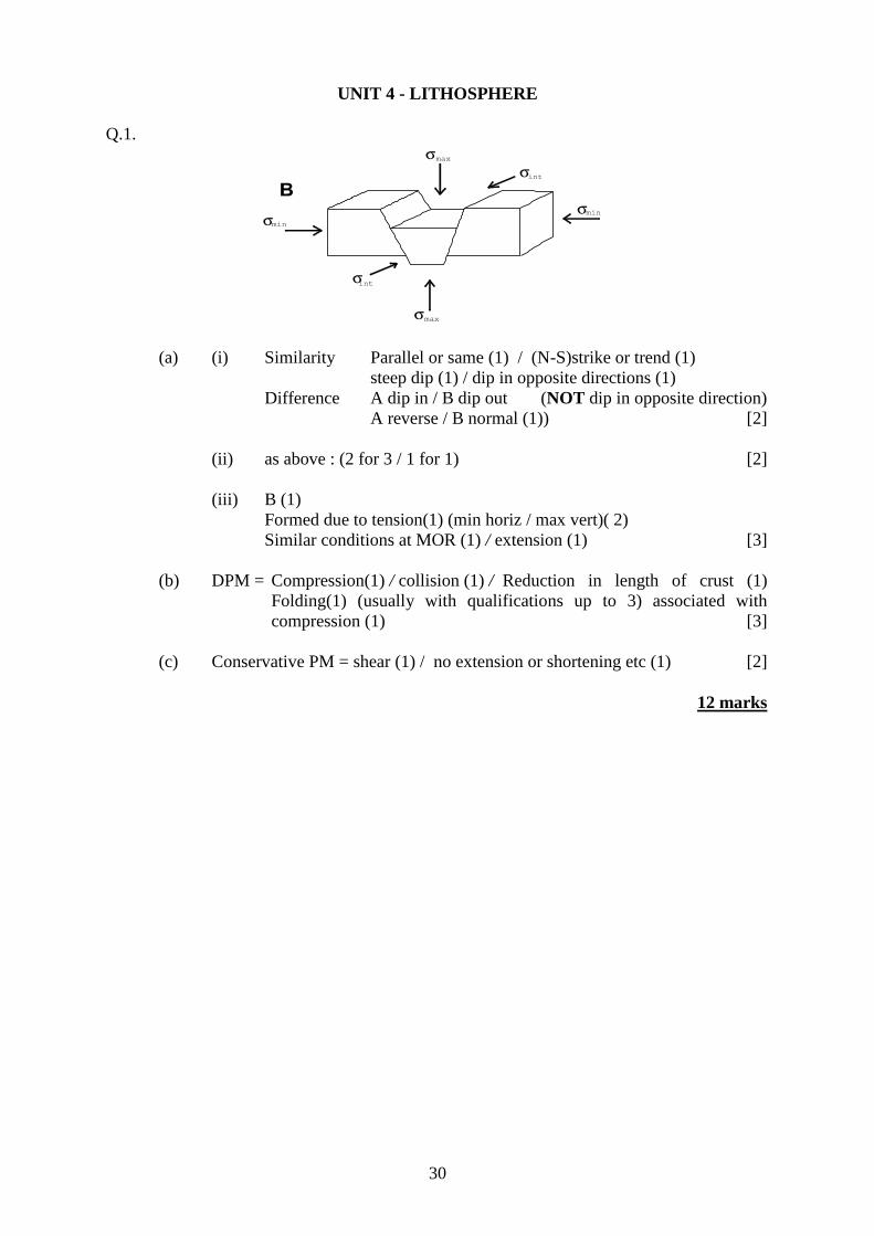
Q.1.
(a) (i) Similarity Parallel or same (1) / (N-S)strike or trend (1)
steep dip (1) / dip in opposite directions (1)
Difference A dip in / B dip out (NOT dip in opposite direction)
A reverse / B normal (1)) [2]
(ii) as above : (2 for 3 / 1 for 1) [2]
(iii) B (1)
Formed due to tension(1) (min horiz / max vert)( 2)
Similar conditions at MOR (1) / extension (1) [3]
(b) DPM = Compression(1) / collision (1) / Reduction in length of crust (1)
Folding(1) (usually with qualifications up to 3) associated with
compression (1) [3]
(c) Conservative PM = shear (1) / no extension or shortening etc (1) [2]
12 marks

31
Q.2. (a) (i) Rock sequences / layers very similar(1) [1]
(ii) P-wave velocities lower in ophiolites (1) [1]
(b) M between L3 and L4 (1)
Change in P-wave velocities / mineralogy (1) / qualification (1). [2]
(Accept between layered and unlayered peridotite as mineralogical Moho)
(c) (i) Mark on Figure 2(b) with an arrow labelled O (1 Reserved)
Plate movement(1) / DPM(1) / subduction (1) / obduction(1) / density
difference(1) (3)
(ii) Mark on Figure 2(b) with an arrow labelled X (1 Reserved)
Youngest lithosphere (1) / "no" time (1) / "no" clastics (1) /
pelagics (1) (3)
(d) Metamorphism(1) / temperature increase(1) / magnetism destroyed(1)
Recrystallisation (1) iron minerals reorientated (1)
Accept other types of meta e.g. dynamic / shearing or chem. / hydrothermal
activity (3)
13 marks

32
Section B
3. Compare and contrast continental and oceanic lithosphere in terms of :
age,
structure, and
composition.
Similarities : Base of lithosphere = 1300degC isotherm
Lithosphere = zone above asthenosphere
Lithosphere = crust and upper mantle
Movement
Continental Oceanic
Thicker 35 to 60km Thinner 5 to 10km (CPM to DPM)
Granitic / equivalent Mafic / basic
Less-dense (not subduct) More dense (subducts)
Sedimentary, igneous and metamorphic
rocks
Layered / 1, 2 and 3 (sediments, pillows,
dykes and gabbros)
Older < 4.2Ga
Tends to be older in"middle" with
vertical stratigraphy / Law of
Superposition
Ridge / abyssal planes / trenches
Younger < 200Ma
Older away from ridge / horizontal
stratigraphy
(May be) folded and faulted ("all" types) Transform faulting common
Spreading
Magnetic striping
Orogenic belts / cordillera Island arcs
4. Discus the extent to which the J Tuzo Wilson cycle of ocean formation and destruction
is supported by the present-day size, structure and distribution of oceans.
(Probably) With reference to Pacific and Atlantic re. sizes and structures.
(Continental splitting rifting e.g. E African)
Ocean formation opening of an ocean basin e.g Red Sea to Atlantic
central ridge MAR
passive margins on each side getting bigger / wider
subduction begins at margin(s)
Closure Pacific / trenches
getting smaller
marginal ridge EPR
Thus one growing whilst other shrinks
(Orogeny where collision occurs)
Conclusion

33
5. Discuss the use of seismology in the distinction between the lithosphere and
asthenosphere. Comment on the possible significance of temperature in the formation
of the asthenosphere.
Seismology = use of P, S and L-waves.
P and S velocity depends upon properties of medium through which they are passing.
Discussion of properties = shear and bulk moduli plus density.
Velocities directly proportional to (square root of) moduli; inversely proportional to
density.
Variation of velocities with depth.
Recognition of a low-velocity zone - 0(?) - 250km depth.
Deeper under continental lithosphere.
Shallower under oceanic lithosphere.
Suggests a semi-molten state.
Corresponds with 13000C isotherm = partial melting of mantle.
Correlation of lower velocity with partial melting.
Low-velocity layer synonymous with asthenosphere.
(Diagrams of seismic wave paths and geotherms).
GCE M/S (June 2004)/Geology/JD

Welsh Joint Education Committee
245 Western Avenue
Cardiff. CF5 2YX
Tel. No. 029 2026 5000
Fax. 029 2057 5994
E-mail: [email protected]
website: www.wjec.co.uk/exams.html