Embed Size (px)
Citation preview
Landslides in Hong Kong
Juhani Aleksi HORELLI
University of Helsinki Faculty of Agriculture and Forestry
Department of Economics and Management Master’s Thesis
May 2005
HELSINGIN YLIOPISTO ⎯ HELSINGFORS UNIVERSITET ⎯ UNIVERSITY OF HELSINKI
Tiedekunta/Osasto ⎯ Fakultet/Sektion ⎯ Faculty Laitos ⎯ Institution ⎯ Department Maatalous-metsätieteellinen tiedekunta Taloustieteiden laitos
Tekijä ⎯ Författare ⎯ Author Juhani Aleksi Horelli Työn nimi ⎯ Arbetets titel ⎯ Title Landslides in Hong Kong Oppiaine ⎯Läroämne ⎯ Subject Ympäristöekonomia
Aika ⎯ Datum ⎯ Month and year Sivumäärä ⎯ Sidoantal ⎯ Number of pages Työn laji ⎯ Arbetets art ⎯ Level Master’s Thesis 18 May 2005 134
Tiivistelmä ⎯ Referat ⎯ Abstract Landslides are natural hazards classified as a form of mass movements, which can be described as downslope movement of soil, sediments and rocks. As landslides can cause serious damages to infrastructure and lives, the public feels unsafe toward these dangers. Therefore, landslides are closely associated with the concept of risks. Risk assessment is used to identify the risk associated with landslides in order to apply various management methods accordingly. The management methods of landslides can be closely linked to those of conventional pollution. Therefore, various environmental economic theories can be adopted to show the similarities of landslide management and conventional pollution management. The role of government intervention on landslides is critically important for reducing the risks from landslides. Hong Kong sets a great example due to its frequent occurrences of landslides, the enormous risks associated and various types of management methods implemented. Hong Kong is one of the most densely populated cities in the world. The dense urban area is surrounded by steep hills, combined with its climate and soils structures making the city prone to landslides. In addition, the lack of space in Hong Kong encourages man-made alterations to the landscape. The risk from a landslide onto Hong Kong’s dense urban area is extremely high with possible devastating effects on infrastructure and human lives. Therefore, the eradication of the landslide risk is important. The research into landslides in Hong Kong is based on the interesting linkage between a natural hazard, pollution and the ways that a society deals with landslides and their associated risks. Avainsanat ⎯ Nyckelord ⎯ Keywords Landslides, Hong Kong Säilytyspaikka ⎯ Förvaringsställe ⎯ Where deposited -- Muita tietoja ⎯ Övriga uppgifter ⎯ Further information --
1
HELSINGIN YLIOPISTO ⎯ HELSINGFORS UNIVERSITET ⎯ UNIVERSITY OF HELSINKI
Tiedekunta/Osasto ⎯ Fakultet/Sektion ⎯ Faculty Laitos ⎯ Institution ⎯ Department Maatalous-metsätieteellinen tiedekunta Taloustieteiden laitos
Tekijä ⎯ Författare ⎯ Author Juhani Aleksi Horelli Työn nimi ⎯ Arbetets titel ⎯ Title Maanvyöryjä Hong Kongissa (Landslides in Hong Kong) Oppiaine ⎯Läroämne ⎯ Subject Ympäristöekonomia
Aika ⎯ Datum ⎯ Month and year Sivumäärä ⎯ Sidoantal ⎯ Number of pages Työn laji ⎯ Arbetets art ⎯ Level Pro-gradu 18 Toukokuuta 2005 134
Tiivistelmä ⎯ Referat ⎯ Abstract Maanvyöryt ovat luonnonkatastrofeja, jotka voidaan luokitella massaliikkeeksi. Maanvyöryt ovat multa ja kivi massoja, jotka liikkuvat rinnettä alas maan vetovoiman avulla. Katastrofin koittaessa tiheään ympäristöön, tuhon seuraukset saattavat olla valtavat. Täten maanvyöryt automaattisesti liitetään tiettyihin riskitekijöihin. Maanvyöryjen riskitekijöiden tunnistamiseen käytetään ‘Risk Assessment’ tekniikkaa. Tämän tekniikan avulla tietyt riskit voidaan tunnistaa, jonka avulla voidaan päätellä mikä on paras mahdollinen maanvyöryjen poistotekniikka tietyssä tilanteessa. Maanvyöryjen ja saasteen rajoittamistavat ovat hyvin läheiset. Täten ympäristöekonomian teorioita voidaan soveltaa maanvyöryjen rajoittamistapoihin. Maiden hallituksilla on suuri valta kontrolloida maanvyöryjä asettamalla rajoituksia, jolla maanvyöryjen määrää voidaan vähentää. Hong Kong on hyvä esimerkki maanvyöryistä, niiden suuresta riskistä ja rajoittamistavoista. Maantieteellisen sijaintinsa takia Hong Kong on erittäin altis tämän luonteisille luonnonkatastrofeille. Suuret sademäärät ja jyrkät rinteet aiheuttavat vuosittain maanvyöryjä. Hong Kongin tiheästi asutulla maa-alueella on asukkaita 6.2 miljoonaa, sekä korkeimpia taloja maailmassa. Katastrofin koittaessa tuhon seuraukset saattavat olla valtavat. Tämän takia teknologia ja informaatio maanvyöryistä Hong Kongissa on huippu luokkaa. Pro-Gradu tutkelma maanvyöryistä Hong Kongissa liittää luonnonkatastrofin, saasteen, sekä miten yhteiskunta hoitaa maanvyöryjä ja niihin liittyviä riskejä. Avainsanat ⎯ Nyckelord ⎯ Keywords Maanvyöryt, Hong Kong Säilytyspaikka ⎯ Förvaringsställe ⎯ Where deposited -- Muita tietoja ⎯ Övriga uppgifter ⎯ Further information --
2
Table of Contents Abstract – English 1 Abstract – Suomi 2
Table of Contents 3
List of Figures 6
List of Tables 8
Introduction 9 Chapter I - Landslides 11
1.0 Introduction 11
1.1 Causes of Landslides 12 1.1.1 Gravity 13 1.1.2 Water 15 1.1.3 Weak Materials 16 1.1.4 Human Activities 16
Chapter II - Risk Assessment 20
2.0 Landslides and Risks 20
2.1 Risk Assessment 21 2.1.1 Hazard Mapping 22 2.1.1.1 Prediction 23 2.1.1.2 Forecasting 24
2.2 Risk Valuation 26
Chapter III - Management of Landslides 29
3.0 Introduction 29
3.1 Stabilisation Methods 30 3.1.1 Cutting of Slope 30 3.1.2 Retaining Wall 32 3.1.3 Artificial Slope 34
3.2 Protection Methods 37 3.2.1 Catch Fences and Ditches 37 3.2.2 Nets, Rock Bolts and Anchors 38 3.2.3 Shotcrete 38 3.2.4 Mulching and Seeding Methods 40
3

Chapter IV - Environmental Economics Theories 42
4.0 Introduction 42
4.1 Costs 42 4.1.1 Cost of Landslides as Natural Hazards 43 4.1.1.1 Private and Public Costs 43 4.1.2 Landslide as an Externality 44 4.1.2.1 Private, Social and External Costs 44 4.1.2.2 Distinction between Public and Social Costs 46
4.2 Responsibility of the External Costs 47 4.2.1 Coase Theorem 47 4.2.1.1 Coase Theorem Explained Through a Landslide
Example 47
4.2.1.2 Shortcomings of Coase Theorem 50
4.3 Government Intervention 52 4.3.1 Direct Production of Environmental Quality 53 4.3.2 Command and Control Regulations 53 4.3.3 Economic Incentive 54
4.4 Cost-Benefit Analysis 55 4.4.1 Cost-Benefit Analysis on Landslide Issues 56
4.5 Willingness to Pay 61 4.5.1 Direct Techniques 61 4.5.2 Indirect Techniques 63 4.5.3 Valuation of Benefits 64 Chapter V - Landslides in Hong Kong 67
5.0 Introduction 67
5.1 Slope Failures in Hong Kong 68 5.1.1 Topography and Geology 69 5.1.2 Demography and Urban Area 69 5.1.3 Geology 71 5.1.4 Rainfall 73
5.2 History of Landslides in Hong Kong 76
5.3 Major Causes of Landslides in Hong Kong 78 5.3.1 Water in Soils 78 5.3.2 Urban Development 80 5.3.2.1 Land Reclamation 81 5.3.3 Case Study of a Landslide in Hong Kong 82 5.3.3.1 The Site 83 5.3.3.2 Rainfall 83
4
5.3.3.3 Landslide 84 5.3.3.4 Ground Conditions and Debris 84 5.3.3.5 Probable Causes of the Landslides 87
5.4 Urban and Non-urban Landslides 89 5.4.1 Landslides Associated with Urban Development 90
5.5 Management of Landslides 93 5.5.1 Man-made Slopes 93 5.5.2 The ‘Greening Techniques’ 94 5.5.2.1 Mulching System 95 5.5.2.2 Planting of Long-Rooting Grass 96 5.5.2.3 Fibre Reinforced Soil System 97 5.5.2.4 Comparisons of the Greening Techniques 98 5.5.3 Maintenance of Slopes 100
5.6 Hong Kong Government Intervention on Landslide Issues 101 5.6.1 Improve Slope Safety Standards 101 5.6.2 Ensure Safety Standards of New Slopes 102 5.6.3 Rectify Substandard Government Slopes 102 5.6.4 Maintain all Government Man-made Slopes 103 5.6.5 Ensure that Owners Take Responsibility for Slope Safety 104 5.6.6 Promote Public Awareness 104 5.6.7 Enhance the Appearance and Aesthetics of Engineered Slopes 105
5.7 Current Situation 106 5.7.1 Government Intervention on Externality Due to Urban
Development 107
Conclusion 109
Discussion 112
Reference List 114
Appendices 119 Appendix A - Landslide Probability Classification Chart 120 Appendix B - Hazard Map 121 Appendix C - Flow Chart of Slope Investigation Procedures 123 Appendix D - Slope with Eroded Shotcrete Cover 124 Appendix E - Slopes with Drainage System 125 Appendix F - Artificial Slopes with Mulching Techniques 126 Appendix G - Landslides 127 Appendix H - Interview with Mr Francis Wong 129 Appendix I - Interview with Urbis Limited 132
5

List of Figures Figure 1.1 Shear Force and Normal Force to Gravity on a Steep
Slope 13
Figure 1.2 Causes of Mass Movements 18
Figure 3.1 The Effects of the Angle in Relation to the Slope Stability 31
Figure 3.2 Cutting of Slope Angle 32
Figure 3.3 A Rock Retaining Walls with (B) and without (A)
Draining Holes 33
Figure 3.4 An Artificial Slope with Various Draining Methods 36
Figure 3.5 Various Protecting Methods Against Landslides 39
Figure 4.1 Externality Cost (Landslide) Induced by Logging 45
Figure 4.2 Comparison of the Financial Costs to the Hazard
Intensity 57
Figure 4.3 Public’s Willingness to Pay for an Environmental Quality
Measured by Housing Rent 63
Figure 4.4 Demand for Improved Safety from Landslides 65
Figure 5.1 The Map of Hong Kong 68
Figure 5.2 Shows the Map of Hong Kong with Urban and Non-
Urban Areas, as well as Gradients of Hills and Slopes 70
Figure 5.3 Map of the Main Types of Rock Types Distributed in
Areas of Hong Kong 71
Figure 5.4 Cross Section of slopes on Northern Hong Kong Island 73
Figure 5.5 The Average Annual Rainfall of Hong Kong 74
Figure 5.6 A Map of the Territory of Hong Kong with Recorded
Landslides During the 24-hour Rainstorm Period of 1993 79
Figure 5.7 The Weather Map of Hong Kong on 16 June 1993 83
Figure 5.8 Measurement of Rainfall at 5-minute Interval on 16 June
1993 84
6
Figure 5.9 Cross-section of the Cut Slope that Fell on the 16 June,
1993. 85
Figure 5.10 The Conditions of Failure of the Slope on 16 June, 1993 86
Figure 5.11 Comparison Between the Urban and Non-urban
Landslides According to Rainfall 89
Figure 5.12 External Cost of Rapid Urban Development 91
Figure 5.13 Mulching Method 95
Figure 5.14 Long-rooting Grass System 96
Figure 5.15 Fibre Reinforced Soils 97
Figure 5.16 Slope Registration in Hong Kong 103
Figure 5.17 Government Intervention on Urban Development 107
7
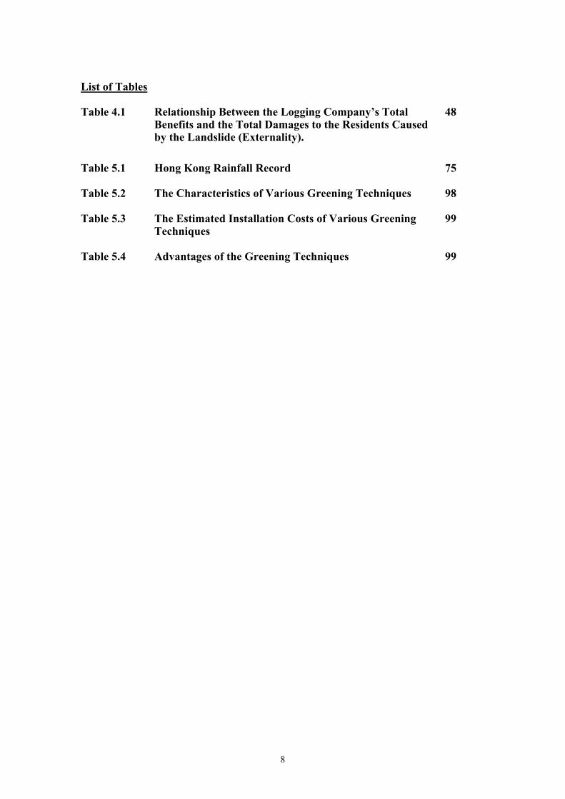
List of Tables Table 4.1 Relationship Between the Logging Company’s Total
Benefits and the Total Damages to the Residents Caused by the Landslide (Externality).
48
Table 5.1 Hong Kong Rainfall Record 75
Table 5.2 The Characteristics of Various Greening Techniques 98
Table 5.3 The Estimated Installation Costs of Various Greening
Techniques 99
Table 5.4 Advantages of the Greening Techniques 99
8
Introduction
Landslides are a natural hazard that causes great damages to human lives and
infrastructure. Landslides are a threat to the public, and therefore, are linked with a
concept of risk. To minimise the risks associated with landslides, various social,
theoretical and physical methods have been adopted.
Hong Kong has a history with annual landslides. The risks in the urban areas are large
as the city is one of the most densely populated in the world. In addition, the land area
in Hong Kong is scarce, which has forced the spread of urban development towards the
steep hills, causing man-made alterations to the landscape. In an area that is naturally
prone to landslides, the man-made alterations would contribute to the failure of slopes.
Combining with the dense infrastructure of the valleys, it could lead to large-scale
destruction and death. As the majority owner of land, the government of Hong Kong is
responsible for slope maintenance to ensure slope safety. This has led to concrete
actions by the Hong Kong government to install regulations, legislation, emergency
units, and various landslide preventative methods to secure the safety of the citizens of
Hong Kong.
The research, firstly, aims to study landslides by looking at their nature, reasons for
failure, the risks that are associated with them, and ways that these damages and deaths
can be minimised or erased. Once a common understanding of landslides is established,
the research, secondly, aims to study landslides through various environmental
economic policies. These policies aim to show similarities in the ways of controlling
conventional pollution, such as air and water pollution, and when a landslide is regarded
as an externality. The research also shows the relationship of rapid urban development
on causing landslides. The theories combine the attributes that are associated with
landslides in Hong Kong and review a possible method in which government
intervention could be used to deal with landslides.
The Government of Hong Kong is the major owner of land in Hong Kong. Therefore,
the safety to the public from landslides is therefore the government’s responsibility.
9
Various government intervention methods used to reduce landslides and protect the
public of Hong Kong have been implemented. Special emphasis will be placed on the
Geotechnical Engineering Organisation (GEO), a Hong Kong government department
dedicated to slope safety.
10
CHAPTER I
Landslides
1.0 Introduction
Natural hazards can be divided into three main categories: atmospheric, endogenic and
exogenic hazards (Bennett & Doyle, 1997). Atmospheric hazards are caused by
processes of atmospheric nature, such as, tropical storms, hail storms, hurricanes and
droughts. Endogenic hazards are results from internal earth processes, such as volcanoes
and earthquakes. Exogenic hazards are caused by the operation of natural earth surface
processes including flooding, coastal erosion, mass movement and soil erosion. It is
important to realise that natural hazards cannot always be categorised into one of these
segments listed above. In many cases, the natural hazard could actually be a
combination of two different types of the categorised hazards above. For example, a
landslide is often triggered off by an atmospheric hazard, such as a tropical storm and
an endogenic hazard such as an earthquake. However, this is a good method of
separating the hazards into basis categories, making a differentiation between the
geological hazards (endogenic and exogenic) and the atmospheric hazards (Bennett &
Doyle, 1997).
11
1.1 Causes of Landslides
Landslides are a form of mass movements. They are large volumes of material moving
downslope under the pull of gravity (Abbott, 2002). As stated by Bennett & Doyle
(1997) as “mass movements can be defined as the downslope movement of soil,
sediment and rock”. These flows generally occur during periods of intense rainfall or
rapid melting of snow. Landslides are commonly found everywhere around the world in
many different forms. However, certain areas are more prone to landslides than others.
Factors such as the steepness of the slope, vegetation density, types of soil content and
its quality should be taken into consideration while reviewing the characteristics
commonly associated with landslides. For instance, places with hilly areas and tropical
storms are more likely to have landslides than other areas.
Landslides usually start on steep hillsides as shallow landslides that liquefy and
accelerate to speeds that are typically about 10 miles per hour, but can exceed 35 miles
per hour (Schuster & Highland, 2001). The slide gathers more mass on its way
downslope making it larger and heavier. Besides carrying soils, rocks and water, the
strength of the slide can carry large items such as boulders, trees, cars and in some
cases, buildings. In most circumstances, landslides are relatively small and with
minimal damages, however, the occurrence of a larger landslide in an area of high
density of population and infrastructure would have enormous destructive power.
Globally, landslides cause billions of dollars in damages and thousands of deaths and
injuries each year (FEMA, 2004). Gravity and the geological factors are seen as the
driving forces of landslides, whilst other factors usually trigger the initial slide. The
initial triggering factors can be categorised as natural and human causes. Natural causes
include large amounts of water from tropical storms, earthquakes and erosion. Human
activities include farming, digging and the building of roads and houses, which all
contribute to a landslide (Uribe et al, 1999). These processes either weaken the soil
structure or add weight to the falling masses of land (Abbott, 2002). All of the above
processes will be discussed in details in this chapter.
12
1.1.1 Gravity
“Every object in the Universe attracts every other object with a force
directed along the line of centers for the two objects that is proportional
to the product of their masses and inversely proportional to the square of
the separation between the two objects” (Newton,1968)
Gravity operates 24 hours a day, everyday of the year, and its law is fixed. The constant
pull of gravity is also the power behind various types of natural erosion. The falling of
rain, flow of water, blowing of wind and the breaking of waves are all controlled by
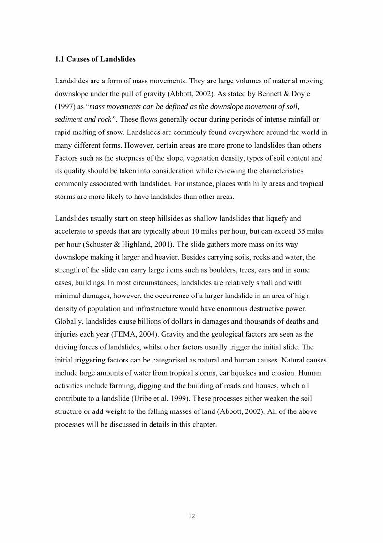
gravity (Abbott, 2002). The power of gravity in landslides can be best described in
figure 1.1.
Normal force
Gravity is one of the driving forces of mass movements. In figure 1.1, the effect of
gravity is shown on a block on a steep slope. There are two different types of forces
determined by gravity, which are illustrated as the black arrows in the diagram. Firstly,
the normal force, which is vertical to the slopes angle enabling the block to stay on the
slope due to frictional characteristics. Secondly, the shear force, which is parallel to the
slope and shows the ability and direction of the block movement. The length of the
Gravity
Shear force
Figure 1.1 Shear force and normal force to gravity on a steep slope.Source: McGeary, Plummer & Carlson (2001:317)
13
black arrows are proportional to the force, therefore the longer the arrow the heavier the
material, due to the steepness of the slope. The stronger the shear force is, the more
likely it is for the block to slide downhill. Friction counteracts with the shear force. If
the friction is greater than the shear force the block will not move (McGeary, Plummer
& Carlson, 2001). The role of gravity and the object’s weight and friction are explained
by Bennett & Doyle (1997) as ‘unstable and therefore prone to failure by landsliding
whenever the forces driving failure exceed those resisting downslope movement. This
balance is known as the factor of safety’. The factor of safety is illustrated by an
equation of:
Factor of safety (F) = Sum of the resisting forces = Strength
Sum of the driving forces Strain
However, if the friction (the sum of the resisting forces) is reduced, for example, by
water, it will then be less than the shear force (the sum of the driving forces), the block
will slide. In other words, if the balance between the strength and strain is not at
equilibrium, the mass will slide downhill. The weigh of the particular block, whether it
describes the mass of the soil or a building, is especially important when finding the
causes of landslides. The gravitational force on a slope can be calculated by taking into
consideration the weight of the block and the angle of the slope (Abbott, 2002). For
example, imagine a 1lb block on a 30º slope. The downhill force is calculated as:
1 lb × sine 30º = ½ lb
This ½ lb is directed towards downslope into the open space. Due to the already existing
gravitational force, any common interruption from a natural hazard to a human activity,
might trigger a landslide. Figure 1.1 shows the laws of physics. These rules apply to
today’s problems with landslides. The block can be seen as a building or a heavy
14

structure on a slope. Therefore, special precautions and attention need to be focussed
onto prevent any possible slope failures. The importance of friction is colossal and the
ways of protecting and increasing it are essential. These will be discussed further in the
following chapters.
1.1.2 Water
Water is a critical factor in causing mass movements. There are several different ways
that water affects soils. Firstly, water weighs and when it gets absorbed into the soil, the
increase in weight is more likely to cause landslides due to the stronger gravitational
pull. Secondly, large amount of water decreases friction, and therefore, reducing the
shear strength on slopes. This is due to the increased pore pressure in which, water
forces grains of debris apart (McGeary et al, 2001). A heavy rainstorm can be the
triggering event in initiating instability of a slope. Tension cracks, steep loose material,
exposed excavation, and poor vegetation, may also lead to instability (Chen & Lee,
2000). On the contrary, a small amount of water in soil can prevent downslope
movement. This is when water does not completely fill the pore spaces between the
grains of soil, creating a film around each grain. Loose grains will stick to each other
due to surface tension, thus increasing the shear strength. This theory is explained
through a sandcastle example (McGeary et al, 2001) as:
“It is the surface tension of water between the sand grains that allows
you to build a sand castle. The sides of the castle can be steep or even
vertical because surface tension holds the moist sand grains in
place…On the other hand an experienced sand castle builder also knows
that it is impossible to build anything with sand that is too wet. In this
case the water completely occupies the pore space between sand grains,
forcing them apart and allowing them to slide easily past one another”.
Water also affects soils and causes landslides by flowing through the rocks, physically
eroding the minerals that hold the rock and soil particles together. As stated by Abbott
(2002), “the removal of cementing material decreases cohesion of rocks and saps some
of a slope’s strength, preparing it for failure by mass movement”.
15
1.1.3 Weak Materials
The quality of soils is also a criterion that should be taken into consideration when
discussing the reasons for landslides. Some soils are weaker than others, thus breaking
more easily when they come under stress. The materials most commonly associated
with earth failures or landslides are the clay materials (Abbott, 2002). Clay minerals are
very small, even too small to be seen through a microscope. A side view of a clay
mineral shows a thin dimension that is split into thin sub-parallel sheets or layers, like
the pages in a book. This structure of soil allows water to strip away elements, thus,
leaving many unfilled positions. As different elements are taken in and others are
removed, the strength of the clay minerals increases and decreases respectively. They
expand and contract when water is absorbed and removed. These constantly changing
conditions cause variations in the strength of clay minerals from month to month, and
year to year. Due to these frequent changes, a hill containing clay minerals becomes
weaker, which gives gravity a greater chance of provoking a slope failure. Other soil
types, which are prone to landslides, are granites and volcanic rocks (Au, Li & Lo,
2001). This is because these soil types are weathered more deeply than others. For
example, the weathering depth of granite rocks can be up to 60 metres deep (Au et al,
2001). In other words, the water forces itself deeper into the ground, loosening the
particles and decreasing the strength, which results in slope failures.
1.1.4 Human Activities
Human activities are often the causes of landslides. There are numerous ways that
human activities contribute to the weakening of soil structures, decreasing its friction,
adding weight to a slope, reducing the resisting mass, and making the angle of the slope
steeper (Abbott, 2002). All of these attributes could have devastating effects if not
monitored well. Human activities reduce slope strength and increase the stress placed
upon it. Human effects such as irrigation, clearing of vegetation, cultivation, and
digging of land reduce slope strength (Bennett & Doyle, 1997). For example, in Los
Angeles, a man forgot to turn off a sprinkler system of his hillside lawn before
departing on a long trip. The soil became saturated, and both the house and lawn were
carried downward in a landslide to the highway below (McGeary et al, 2001).
16
Agricultural methods in general could have a degrading effect on soil structures. The
loss of minerals in soils also weakens its complexion; and when placed in a harsh
condition, it is more likely to break and slide. One such agricultural method is the slash
and burn tactic, which is commonly used in developing countries. Slash and burn means
the clearing of natural vegetation, such as trees and shrubs and the burning of the land
for the use of agriculture (Uribe et al, 1999). This shifting cultivation method has
devastating effect on soils, making it initially very fertile for the crops to grow, but then
in a few years the soil becomes tired, making the land arid. As the soil becomes infertile
and crops do not produce high yields, farmers move on to another location and abandon
the land (Bulte and Van Soest, 1996). This unsustainable method not only degrades
land, vegetation and ecosystems, but also makes the land more prone to landslides.
Barcia (2004) states that, “ the ‘kaingin’ system of farming has been causing rapid soil
erosion, low soil fertility and productivity, and minor landslides that have swept the
town’s outskirts. In 1992, several people were buried alive when the loosened soil caved
in”. The local Philippine ‘kaingin’ system is referred to as the more commonly used
term ‘slash and burn’. The clearing of vegetation, such as logging, reduces the friction
on a slope. As mentioned earlier, if this friction is erased, there is nothing that stops a
landslide. For example, in May 2004, Haiti was struck by a tropical storm, Jeanne.
These heavy rains caused floods and landslides. The main reason of the landslides that
caused deaths and damages to infrastructure was deforestation. As stated by the Haitian
Prime Minister, Gerard Latortue, at the Summit of the European and Latin American
Leaders in Guadalajara, Mexico, “the deep cause of this situation is the deforestation of
Haiti…we have lost more than 80 percent of forest because people like to use wood
charcoal as a source of energy," (AFP, 2004).
On the other hand, excess stress on slopes can also be the cause of landslides. This is
usually caused by factors, such as loading on top of a slope and removal of resisting
mass at the bottom. Loading refers to the process of increasing the weight on top of the
slope. The building of human infrastructure, such as houses and roads, is the main cause
of increased weight, and therefore, the increase of stress on slopes. In addition, the
adding of earth or artificial fills to extend the land area on top of the hill, for example, is
an increase to the driving force. Another factor of increased stress on the slope is the
reduction of the resisting mass. As mentioned earlier, the slope is stable only when the
resisting force and the driving force are at equilibrium. However, when the resisting
17
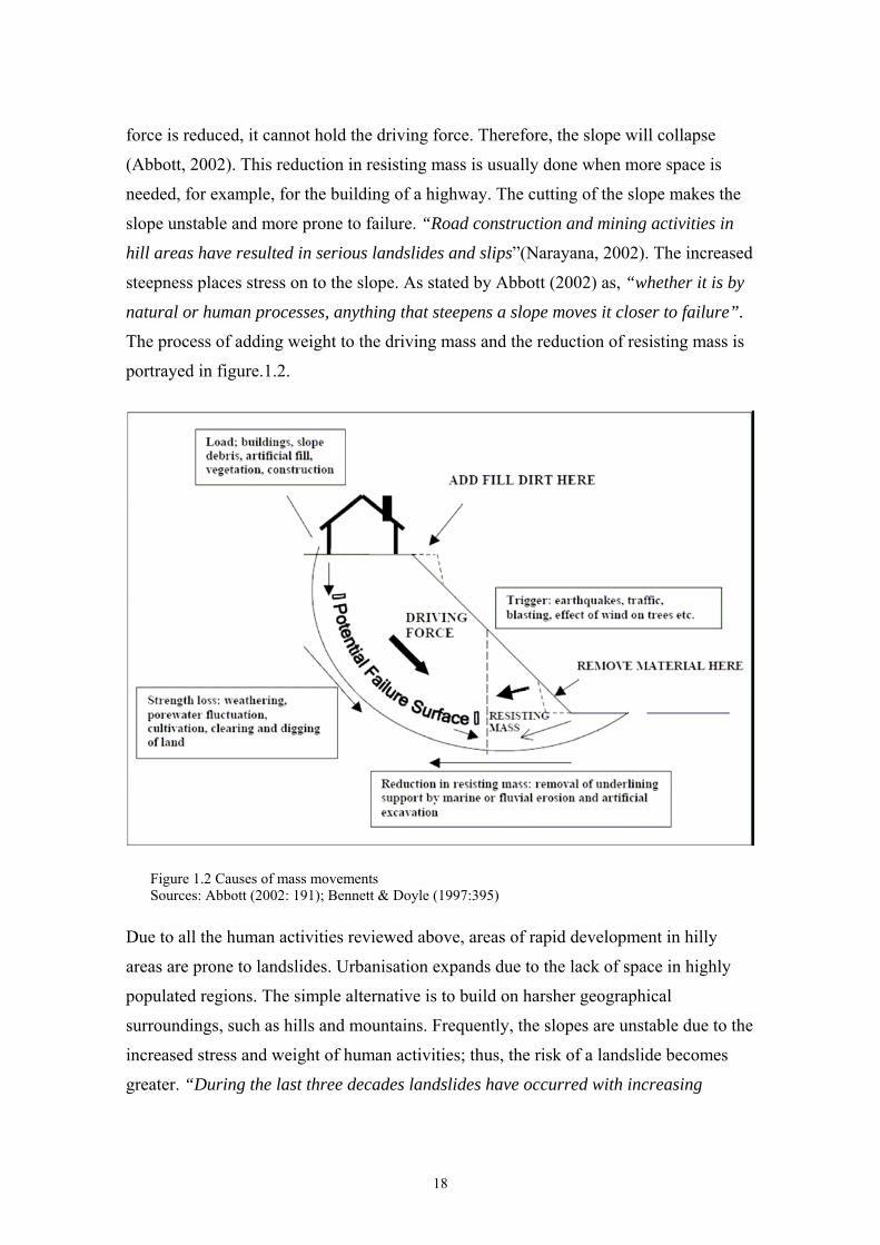
force is reduced, it cannot hold the driving force. Therefore, the slope will collapse
(Abbott, 2002). This reduction in resisting mass is usually done when more space is
needed, for example, for the building of a highway. The cutting of the slope makes the
slope unstable and more prone to failure. “Road construction and mining activities in
hill areas have resulted in serious landslides and slips”(Narayana, 2002). The increased
steepness places stress on to the slope. As stated by Abbott (2002) as, “whether it is by
natural or human processes, anything that steepens a slope moves it closer to failure”.
The process of adding weight to the driving mass and the reduction of resisting mass is
portrayed in figure.1.2.
Figure 1.2 Causes of mass movements Sources: Abbott (2002: 191); Bennett & Doyle (1997:395)
Due to all the human activities reviewed above, areas of rapid development in hilly
areas are prone to landslides. Urbanisation expands due to the lack of space in highly
populated regions. The simple alternative is to build on harsher geographical
surroundings, such as hills and mountains. Frequently, the slopes are unstable due to the
increased stress and weight of human activities; thus, the risk of a landslide becomes
greater. “During the last three decades landslides have occurred with increasing
18
frequency in the Highlands of Sri Lanka, due to increasing population and people
migrating upslope for the construction of their houses on unstable lands” (Dahanayake,
2003).
With urbanisation expanding and population density being high, the possible damages
to human lives and infrastructure become enormous. The rapid expansion of
urbanisation is also a major worry in densely populated cities like Hong Kong. The risks
associated with landslides will be discussed in Chapter two.
Slopes do not fail for just one reason. Most failures have multiple causes. Over long
periods of time, a slope may be under heavy stress. Gravity constantly pulls the soil
mass, heavy rains and water erodes and adds weight to the soils making the slope
heavier and to lose its strength. Eventually, a natural or human activity, such as a
hurricane or a construction of a road, will bring the slope down in a single massive
event (Abbott, 2002). Landslides and the damages that they caused can be reduced
through utilising the knowledge of these natural hazards. By monitoring, knowing the
areas most prone to landslides, maintaining the quality of a slope, erasing human-
induced environmental problems such as slash and burn and by proper planning of
infrastructure on slopes, the amount of landslides can be decreased. By learning what
causes landslides, where and when they occur and how to stabilise slopes, people can
learn to avoid them and lessen the damages that landslides cause to human lives and
infrastructure. These questions will be discussed in the evaluation of risk, especially
through risk assessment in the next chapter.
19
Chapter II
Risk Assessment
2.0 Landslides and Risks
Landslides are linked with the concept of risks. The uncertainty of the occurrence of a
landslide at any time of any place, the possible damages and deaths that might be
caused is a constant strain. Therefore, it proposes a risk to people as well as the
infrastructure. This places a socio-economic importance to the meaning of landslides
(Bennett & Doyle, 1997). The risks caused by landslides and other natural hazards are
determined by the location of settlement and infrastructure in areas prone to natural
hazards. Inadequate and improper design of infrastructure and unsafe socio-economic
conditions might also increase people’s vulnerability to natural disasters (Uribe et al,
1999). Due to the factor of uncertainty, methods of defining risks and how to decrease
them have been adopted. There are numerous ways to reduce landslide risks. It could be
done through knowledge, education, prediction, forecast, stabilisation and protection
methods, and government intervention. Field & Field (2002) separates risk analysis into
three main categories. They are (1) risk assessment, (2) risk valuation, and (3) risk
management. Risk management is discussed in chapter three with various management
methods. Since risk is an essential part of the study of landslides, these categories would
be reviewed in separate sections. Therefore, it is important to review risks from the
geographical, social and economic perspectives, and not simply as a single
characteristic of landslides.
20
2.1 Risk Assessment
Knowledge of a natural hazard is the first aspect that should be investigated accurately
when finding ways of reducing landslides. Examples of previous landslides are
important in finding their reasons of occurring, frequency, damages caused and ways
that they could have been prevented. The information in turn can be used in ways that
could prevent other landslides from occurring. The knowledge and nature of landslides
obtained from various sources could provide guidance on how to avoid the damages and
deaths that caused (Uribe et al, 1999). By researching a specific site, it can be
determined whether a house or a road should be built in that area. In other words, the
probability of a landslide, the area’s history, its soil content and structure, and the
steepness of the hill, can help to determine when a landslide might occur and what
damages it could cause. This process is called risk assessment. Risk assessment is
carried out by gathering information through surveillance, forecasting and prediction
into a document called a hazard map. With the use of a hazard map, the probabilities of
the occurrence of a landslide and the magnitude of the possible slide can be calculated.
With this information, the damages caused to infrastructure and lives can also be
measured. This will be reviewed through assessing vulnerability, which is a theory of
risk assessment in measuring the cost of the landslides. Coburn, Sspence & Pomonis
(1994) describes risk assessment as:
“an analysis and combination of both theoretical and empirical data
concerning: the probabilities of known disaster hazards of particular
force or intensities occurring in each area (‘hazard mapping’); and the
losses (both physical and functional) expected to result to each element
at risk in each area from the impact of each potential disaster hazard
(‘assessing vulnerability’)”.
Governments and various organisations and institutions can reduce landslides and the
damages that they cause through the introduction of policies and laws. This controlling
method is called government intervention (Kahn, 1995). Governments also have the
important responsibility to inform the public of the dangers of possible landslides. By
informing the public, losses of lives and damages to infrastructure can be minimised by
avoiding the site and protecting valuables. Education about the natural hazard and its
21
characteristics is also important for the public to learn how to prevent landslides from
happening (Uribe et al, 1999; USGS, 2004). For example, changing conventional
agricultural methods to more sustainable methods will reduce soil erosion and therefore
landslides. Government intervention and other environmental economic theories will be
discussed in depth in chapter four. The case study of Hong Kong will show how these
theories are implemented into reality. For example, Hong Kong’s government
intervention methods on landslides include educating people’s awareness, management
and responsibility of landslides.
2.1.1 Hazard Mapping
“To mitigate and prevent landslide disasters, forecasts of the
occurrence conditions and prediction of the accumulation zone of the
landslide are necessary both theoretically and practically” (Chen &
Lee, 2000).
The prediction and forecasting of landslides relies on the knowledge gained from the
production of hazard maps. The stability and the possible vulnerabilities of slopes are
researched to determine how safe the area around the slope is from possible landslides.
With the use of topographic maps, terrain maps, soil maps, vegetation cover-maps,
aerial photographs, bedrock reports and research studies, a hazard map is formed
(Howes & Swanston, 1994). This overall information package gives a detailed analysis
of the geographical features of the landslides from which the timing, size, magnitude of
the risks and economic losses can be estimated. The information gathered through the
hazard map is also an essential part of the planning process to decide whether it is safe
to construct on a specific area. It is important that a building permit would not be
granted if an area is prone to severe landslide activity, unless the potential future
impacts are fully reviewed into the design.
In order to assess risks, prediction and forecasting are the two prime activities to be
carried out. Prediction determines the likelihood of a given slope failure. More
specifically, forecasting concentrates on the identification of the location, timing and the
magnitude of the initial failure (Bennett & Doyle, 1997).
22
2.1.1.1 Prediction
The prediction method operates in two different ways; firstly, by determining the
instability of the chosen site, and secondly, by determining the regional variation of
landslides and their potential (NBRO, 2003). A civil engineer or an engineer geologist
in the site investigation process usually carries out the examination of the slope
stability. A factor of safety is determined by a calculation of the total shear stress on the
slope, which is then compared to the shear strength, as discussed in chapter one. This
also includes the investigation of the surface of the slope, the soil structures and content,
in order to give a more detailed analysis of the slope’s condition (McGeary et al, 2001).
The regional variation of landslides can be determined by methods of mass movement
inventory mapping, qualitative slope classification and numerical scoring systems.
These three methods are forms of hazard maps. However, a combination of all of these
methods will produce the most effective and specific hazard map.
Mass movement inventory mapping involves the mapping and recording of all active
mass movements within an area by using a combination of air photographs and field
mappings (Bennett & Doyle, 1997). By using this method, the areas prone to landslides
can be classified into problem areas. This helps to register the areas that are more prone
to landslides, determine the risk involved, et cetera. However, this method has an
Achilles heal since it cannot identify the areas, which have no history of failure, but are
indeed unstable at present.
Qualitative slope classification, on the other hand, is a procedure where a field geologist
classifies an individual site. The field geologist is asked to assess the stability of a slope
from visible evidence. In other words, to provide an analysis of how close a slope is to
failure (Hydrometrics, 2003). This is a difficult task since it might lead to serious
consequences if a mistake in judgement is made. On the contrary, if the analysis is too
cautious, it will lead to unnecessary and expensive site investigation work, causing an
increase in the project costs. This approach is totally dependent on the experience and
skills of the geologist. In addition, this system is difficult to audit as the quality and
truth relies solely on the researcher (Bennett & Doyle, 1997).
Numerical scoring systems are based on an approach in which all the available data
relevant to the regional slope stability are collected, examined and combined in order to
23
determine a numerical value of hazard susceptibility. This approach uses the techniques
of both mass movement inventory mapping and qualitative slope classification
combined with lithology, structural geology, slope angle, soil structure or sediment
cover, land use and hydrology (Howes & Swanston, 1994). It gives a full analysis of the
slope and grades it according to its probability and danger of falling. A classification of
the areas susceptibility to failure is characterised into three or six classes (Bennett &
Doyle, 1997). A landslide probability classification chart is shown in Appendix A.
As mentioned earlier, the most reliable and professional hazard map is a combination of
all possible methods of collecting data on landslides. The quality of the information in
the hazard map depends on the various maps, reports, aerial photographs and analysis
that have been carried out in the site (Howes & Swanston, 1994). Once the hazard map
has been produced, it will be analysed, then predictions and forecasts about landslides
can be given. An example of a hazard map is shown in Appendix B. Appendix C shows
a flow diagram of procedures of slope investigation.
2.1.1.2 Foreca sting
The method of forecasting is used to determine the location, character, magnitude and
timing of specific slope failures. This method is used especially in situations where
landslides occur frequently in the same area, for example, during an annual rainy
season. Depending on the scope of the landslide and its possible casualties, deaths and
damages caused, various measures should be undertaken. Remedial action or evacuation
of the areas, are usually the actions most commonly used. It involves careful monitoring
of slope characteristics in order to recognise changes in the slope over time.
Identification of historical records is also important, as well as other hazard mapping
characteristics. For example, melting snow or heavy rains have triggered landslides in
Rocky Mountains, USA, every year. During that time of the year, the area is identified
as a high-risk zone for landslides (Chleborad, 1997). This information is important for
people to know when to take special precautions or to avoid the site, and therefore,
lessen the damages caused by the landslide. In other words, the dangers of landslides
are identified by hazard mapping methods. Their failure time and size is forecasted to
minimise the risks and damages caused.
24
Once the characteristics of the landslide are determined, and where it is most likely to
fall, the possible damages caused can be predicted. A method called assessing
vulnerability is used (Hydrometrics, 2003). This method determines the costs to lives
and infrastructure in that particular area according to the magnitude of the landslide.
This strategy also lists the buildings and people most vulnerable to the natural hazard.
This risk valuation places an order of importance, firstly, to the most vulnerable and
important, and secondly, to essential necessities that a society needs in a case of
emergency (Coburn et al, 1994).
25
2.2 Risk Valuation
As stated by Bennett & Doyle (1997), landslides are “naturally occurring phenomena
which only become hazardous due to the presence of human infrastructure”. The risks
of the damages caused by landslides increase as more people and investment are under
possible threat from this natural hazard. Risk assessment when reviewed in economic
terms is called ‘assessing vulnerability’ or ‘degree of loss’ (Bennett & Doyle, 1997).
Assessing vulnerability requires understanding the location and importance of those
things that the community values. These are mapped through risk valuation. Critical
infrastructures that provide essential products and services that are necessary to
maintain the welfare and quality of life should be identified as valued resources. Other
critical infrastructures such as, bridges and communications facilities, which are
essential in the case of an emergency, should also be identified at a high value.
To assess the vulnerability of these assets, their locations should be mapped into a map
or on a Geographical Information System (GIS) and compared to the risk factors
associated with landslide risks. The GIS has become an important tool for landslide
susceptibility mapping because it provides functions of handling, processing, analysing
and reporting geospatial data. A slope stability model can also be entered into the GIS
to calculate the special distribution of the factor of safety in a particular region. This
technology has greatly helped in the assessment of risks from landslides (Dai & Lee,
2001).
A significant factor in the impact of any hazard is the effect it has on people. The
severity of the impact is related to the intensity of the hazard, the population affected,
and the population’s ability to protect itself (Coburn et al, 1994). In addition to the
geographic location of any potential hazards, it also highlights the sensitive populations
that may be more vulnerable. The locations of facilities, housing or vulnerable
populations should be mapped and given special emphasis in the risk evaluation
process. Vulnerable populations include the young, the old and the infirm. Schools, day
cares, nursing homes, hospitals, et cetera, should also be identified as facilities serving
vulnerable populations (Hydrometrics, 2003).
It is difficult to evaluate the possible costs of a landslide, as some buildings are more
resilient than others to such disaster. Also, the location of the people and their condition
26
is difficult to determine. Therefore, in case of a landslide, it is always impossible to
determine the final damages and costs that are affiliated with it. However, the
calculation of risk presents a general assessment of the vulnerability of structures,
people, and critical facilities to individual hazards or multiple hazards (Coburn et al,
1994).
The equation that is commonly used to calculate overall risk values is:
Overall Risk Values = Exposure x Frequency x Hazard Loss Magnitude
Exposure represents the structures, vulnerable population, or critical facilities at risk.
Frequency is the annual number of events determined by calculating the number of
hazard events and period of record through hazard mapping methods. Magnitude in the
equation represents the percent of damages expected in the landslide (Hydrometrics,
2003).
As mentioned earlier, the severity of the damages caused by a landslide is going to
increase with the density of the population and infrastructure involved. Another
calculation reviewed by Bennett & Doyle (1997) takes these variables into
consideration. Risk assessment can be summarised in the equation of:
Rω = Pω X Dω
In this equation Rω is the risk, Pω is the probability of the landslide reaching a level X,
which is dangerous during a given period (hazard), and Dω is the probability of the
given damages when level X is reached (vulnerability). The value Dω will grow as a
town or city grows (Coburn et al, 1994). This is an important point when reviewing the
possible costs that landslides might afflict on Hong Kong. The scarcity of land has
forced a high density of people and infrastructure into a very small area prone to the
27
risks associated with landslides. This increases the possible risks and the costs from
landslides into extremely high numbers. Therefore, public safety through slope
stabilisation and protecting measures becomes vitally important. Large investment is
placed upon these techniques and into research to find more improved ones, as the
consequences can be devastating.
Another element of risks is called ‘risk perception’ (Bennett & Doyle, 1997). Risk
perception involves public safety. In other words, it asks the question of whether a
person is feeling safe or unsafe. Risk perception can also be linked to peoples
‘willingness to pay’ for a necessity, in this case the safety from landslides. This will be
further discussed in chapter four. The opinion of the public has a major weight on the
decision-making process of whether a retaining wall or other slope stabilisation or
protection measures should be carried out. For example, residents in coastal
communities often feel ‘safer’ after the construction of a concrete sea wall rather than
after the simple replenishment or nourishment of the beach (Bennett & Doyle, 1997).
This statement also applies to people being around the landslide prone areas. Once the
risk has been perceived, a mutual decision to lessen or eradicate the landslides and the
risks associated is made among the various stakeholders in the area. This process is
called risk communication. Theoretically, the most socially, environmentally and
economically optimal solution is reached to erase the risks associated with landslides
that would benefit all parties involved. There are multiple landslide management
methods, which reduce landslides, protect populations and infrastructure. It also
provides information on how not to cause them and avoid them. These methods are
discussed in the following chapter.
28

Chapter III
Management of Landslides
3.0 Introduction
The management of landslides is vital to minimise the risks that they might cause,
which in turns, reduces the possible deaths and damages (Uribe et al, 1999). After the
possible risks of a particular landslide are identified through hazard mapping, the
options to counteract them are similar to those of other natural hazards. These options
are: (1) do nothing and accept the loss; (2) avoid the site; (3) remove the problem; and
(4) mitigation works and careful building designs (Bennett & Doyle, 1997). The ‘do
nothing’ option is only a realistic one when the problem either cannot be avoided and
the cost of stabilisation work is prohibitive, or when the landslide is just simply too
difficult to manage. Once the hazard mapping has been carried out and the accurate
information and actual risks are identified, avoiding the problem site would become the
best and easiest option. However, this option might not be the most practical one in
areas where land is scarce. Building on slope is simply inevitable in densely populated
areas. The ‘do nothing’ and avoiding the site are a passive approach toward the
problem, whereas the following two would be more active ones. Removing the problem
is to eliminate the possible landslide risks by physical prevention methods. It is
effective since it disposes of the driving mass that falls during a landslide. It requires a
lot of research and physical work with time and capital investment. Mitigation and
careful building design aims to stabilise the slope and to minimise the possible risks in
situation where construction on a landslide-prone site is inevitable. The methods used
can be divided into two different methods: the stabilisation and protecting methods.
These physical stabilisation and protection methods will be elaborated further in their
own sections (Chatwin, 1994).
29
3.1 Stabilisation Methods
Usually the landslides can be physically stabilised or the damages of landslide can be
lessened through protection. In human-induced alterations on natural terrain, expert
engineering is essential. As described in chapter one, construction would make the slope
more susceptible to landslides (Abbott, 2002). It happens (1) when the base of the slope
is undercut, removing the resisting mass that supports the slope; (2) when vegetation is
removed during construction; (3) when buildings constructed on the top of the slope,
which adds weight; and (4) when extra water is allowed to drench the soil. With the
knowledge of these actions being an initiative for landslides, methods have been raised
to minimise them.
There are several physical methods that can be used to decrease the risk of landslides.
Firstly, by cutting the slopes angle, which reduces the gravitational pull of the mass.
Secondly, by placing a retaining wall at the cutting of the slope to stop downward
movement of mass. Thirdly, by building of an artificial slope. All of these slope
stabilisation methods have many alternatives to their shape, structure and covers
(Bennett & Doyle, 1997). All of these physical landslide prevention methods will be
reviewed in more details. Their aesthetic qualities and ways of improving them will also
be looked at especially in relation to the case study of Hong Kong. These special
techniques will be reviewed in the Hong Kong section.
3.1.1 Cutting of the Slope
The cutting of the slope is a practical method to reduce the possibility of landslides. By
decreasing the angle of the slope, the gravitational pull, as well as the shear force is
reduced by the removal of the overlaying material (ERM, 1998). The slope can be cut in
a single cut or a series of terraces. One effective way is to cut materials from the steeper
upper part of the hillside, which reduces the slope angle, and is used to fill the base to
give further support to the slope. When a slope is cut, it should be less than 30° -35°,
which is the maximum angle at which loose material is stable (Watkins & Hughes,
2004). However, 26° is the angle where landslides are most common to occur. Figure
3.1 shows the angles of a slope according to the likelihood of slope failure. The effect of
30

the angle on the flow speed is also shown. The landslide will accelerate downslope until
the slope is gentler, where the flow slows and stops.
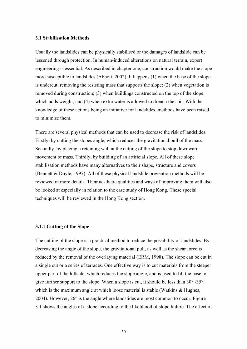
Figure 3.1 The effects of the angle in relation to the slope stability.Source: USGS (2004)
Once the slope is cut to an angle that is safe, it is usually sprayed with concrete or
planted with natural vegetation. Slope cuts constructed in this way are usually reseeded
with rapidly growing grass or plants with intense rooting systems. These roots help hold
the soil particles together and make the slope more solid. The vegetation cover also
minimises future erosion from running water (McGeary et al, 2001). Figure 3.2 shows
(A) a hazardous road cut of a hill with potential landslide, (B) the same hazardous road
cut after a removal of the mass that might slide.
31
Fig 3.2 Cutting of the slope angle Source: McGeary et al (2001:329)
After the cutting of the slope, it is recommended that some form of a toe protection is
installed to prevent basal erosion, which will cause the re-steepening of the slope
(Bennett & Doyle, 1997). This method will also prevent downward movement and
make the slope more stable. The cutting method is therefore an effective way of
decreasing the risk of landslides. If the force of gravity and mass is decreased, this will
ultimately lessen landslides. Obviously the cutting methods are restricted to certain
extent. Certain areas are geographically impossible to access with large machinery. In
addition, not all slopes can be cut due to their enormous size and structure.
3.1.2 Retaining wall
Retaining walls are structures built to support a soil mass permanently. They are usually
built where a cut has been made in the slope in order to support the cutting so as to
prevent it from falling. They are also built to support building platforms and roads. This
is a common practice to prevent downslope movement (McGeary et al, 2001). However,
it is important to know that they are not used to stop a landslide, but to prevent it from
happening (Chatwin, 1994). However, the retaining wall alone is not always effective in
32

holding the mass in place. For example, if the slope is not drained well, pressure will
build inside and eventually burst through the wall. With the usage of drains and
weepholes in the walls, the water will flow through, so that it will not decrease the shear
strength or build up pressure in the slope. “The retaining wall with drain (weep) holes
prevent water retention and the build-up of hydrostatic pressure behind the wall’
(Wilson, 2004). The excess weight caused by water is also removed through this
method. These weepholes are usually 75-100 mm in diameter and spaced at 1.5-2 metre
intervals vertically and horizontally (Au et al, 2001). Figure 3.3 shows (A) a retaining
wall that is not drained, which causes pressure to increase, which in turn pushes the wall
forward. Eventually the wall will fall. Part (B) shows a wall with a drainage system,
which allows the water to flow through the wall with the aid of drains and weepholes.
Fig 3.3 A rock retaining walls with (B) and without (A) draining holes Source: McGeary et al (2001:328)
The retaining walls are usually constructed from concrete blocks with steel reinforcing
rods. However, walls can be constructed from several types of materials: rock, timber,
steel and reinforced earth, et cetera (Chatwin, 1994). Each material has their advantages
in certain situations, but cost is usually the determinant in which material is to be used.
33
In Brazil, a project to reduce the damages of landslides used old tyres to build a
retaining wall. The tyres are very flexible and in case of a landslide they are more
resilient than a wall constructed out of concrete. In addition, this is a very cost-effective
way of reusing resources for an important purpose. “A team of Canadian and Brazilian
researchers has discovered that the tyre walls, built for less than one-third of the cost of
conventional anchored concrete retaining walls used elsewhere in the city, may be more
effective at stopping landslides during the rainy seasons” (Shore, 1999).
3.1.3 Artificial Slope
Artificial slope is another common practice of landslide prevention. They are most
commonly found in urban areas and roadsides. The artificial slopes are usually
constructed out of concrete or the ground is battered into a hard surface. The slopes
have various features, such as surface drains, cut off drains and pipe holes (Halcrow,
2001). The draining methods help to dispose of water effectively, and therefore, make
the slope stronger and more resilient. The artificial slopes are a collection of features
that make a slope more stable. Besides the different draining methods, the usual
stabilisation processes are also used. These are by reducing the weight at the top of the
slope, increasing toe support and decreasing the angle of the slope, et cetera. All of
these methods are also used individually to strengthen the stability of natural slope
(Abbott, 2002; McGeary et al, 2001)
As mentioned earlier, the drainage of water from slope is essential to its stability. Water
physically erodes soils, adds weight and reduces friction, therefore, increases the shear
strength and builds up groundwater pressure, which all contribute to landslides (Abbott,
2002). For that reason, adequate drainage of water is the most important element of
slope stabilization. Drainage is also an important and effective prevention method
because it increases the strength of the soil and reduces the weight of the sliding mass.
Drainage can be classified as ‘surface drainage’ or ‘subsurface drainage’. Surface
drainage measures are effective with low cost but large benefits. They are recommended
on any potential or existing slides. Subsurface drainage is also effective, but can be
relatively expensive (ERM, 1998).
34
Water has to have a steady gradient in order to flow down the slope. Standing water on
the slopes can infiltrate into the soils or concrete and cause a slide. Water also needs to
be directed. This is done either by surface or subsurface drains. Surface draining is done
mainly through surface ditches, surface drains or cut-off drains. Surface drainage is
especially important at the top of the slope, where the system of cut-off ditches is built
horizontally across the slope and vertically at the edges of the slope, where runoff water
is led away. The surface drains are spaced vertically and horizontally throughout the
slope with different patterns. They are usually Y-shaped or herringbone patterns
(Bennett & Doyle, 1997).
Subsurface drains are done through drainpipes or drainage trenches. Drainage trenches
direct the possible flow of groundwater to the bottom of the slope. This drainage
method reduced the build up of pressure and weight in slopes by directing the water out
of the slope. The second subsurface draining method is the usage of drainpipes. The
drainpipes are drilled to the bottom of the slope and should be deep enough to intersect
the failure surface. The drainpipes are usually approximately 5cm thick, spaced at 5 to
10m intervals and filled with sand for good infiltration (Chatwin, 1994). An artificial
draining slope is shown in figure 3.4. Besides all of the draining methods described
above, it also has a toe protection that gives support to the slope, as well as working as a
drain by letting water run through it.
35
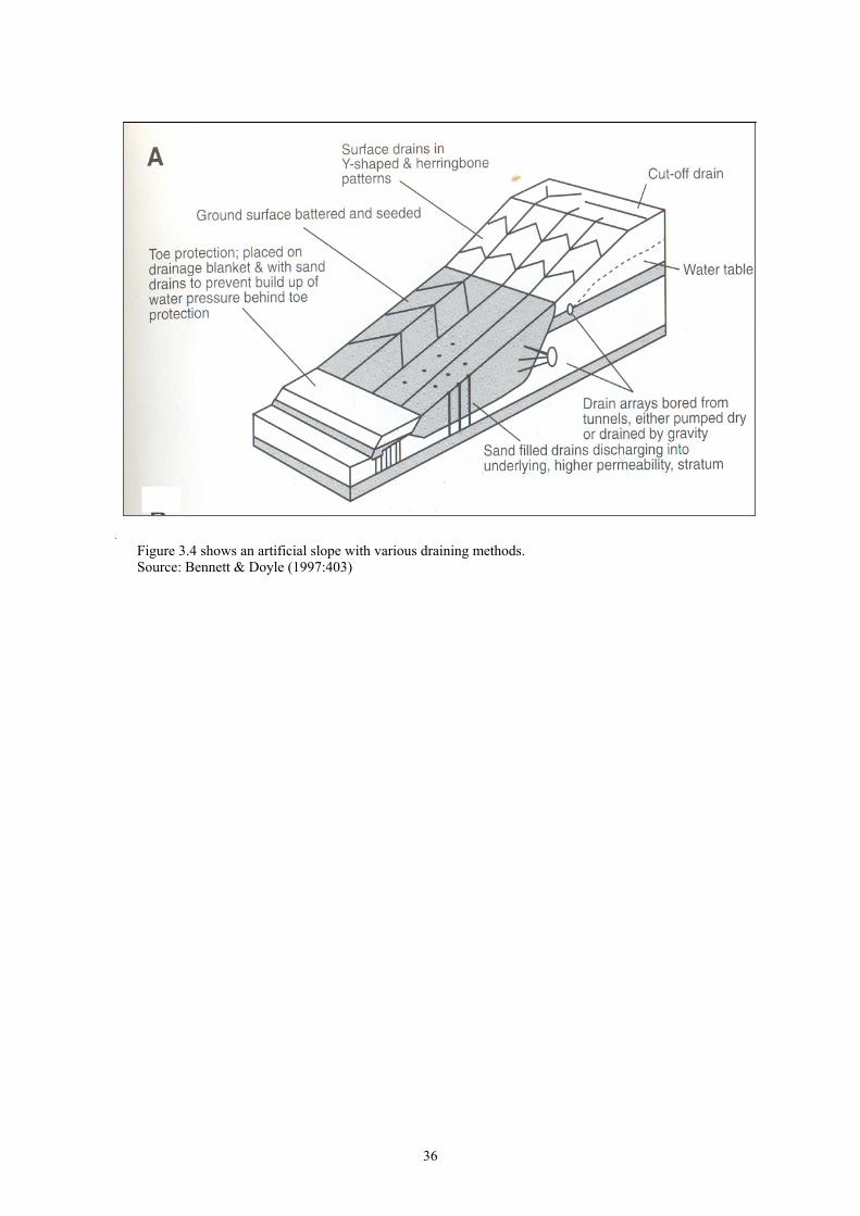
Figure 3.4 shows an artificial slope with various draining methods.Source: Bennett & Doyle (1997:403)
36
3.2 Protection Methods
Protection measures are used whenever there is something valuable downstream, such
as human lives or infrastructure, and when it is impossible or too expensive to stabilise
the slopes above. Slope failures are very difficult to protect against because once they
start to fall, their enormous size and energy is usually too strong to be stopped (Schuster
& Highland, 2001). Containing such a force with a manmade structure is very difficult.
However, there are several ways that have been designed to slow the landslides down,
and therefore, lessening the damages they cause. The methods available for landslide
protection include: catch fences, catch ditches, netting strategies, and rock bolts and
anchors (Chatwin, 1994). All of these methods require geotechnical expertise to
determine the size, location, and spacing of the structures.
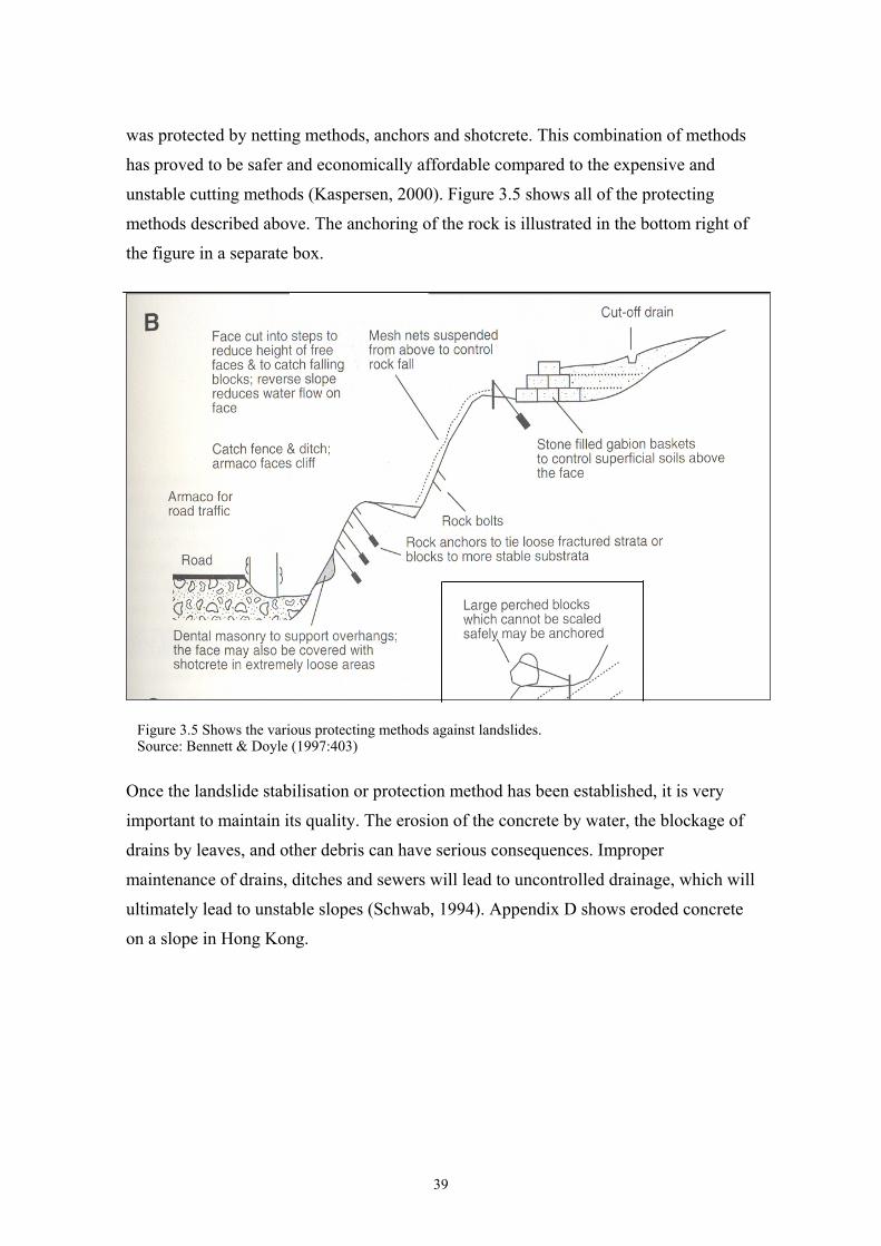
3.2.1 Catch Fences and Ditches
Catch fences are steel fences built into the bed of steep mountain channels. They are
installed at the immediate upstream of the road and are cemented into the bed and sides
of the channel. The fences typically are constructed of welded steel railway rail. The
foremost function is to catch large pieces of wood that flow down the channel during
storms, at the same time allowing the passage of water to flow through. When located
on the lower part of the slope, they can be effective in catching materials out of the
landslide, therefore reducing its size and strength. Catch fences should be approximately
1.5-2.0 m high. They should be sunk into the ground at equal depth, at a minimum of 1
m, and about 20-50 m upslope from the roads or other constructions (Chatwin, 1994). A
catch ditch on the other hand, is a large excavated basin into which a landslide runs or is
directed. The catch ditch quickly reduces the slides energy when it is forced to deposit
its load. Abandoned gravel pits or rock are sometimes used to make catch ditches
(Bennett & Doyle, 1997).
37
3.2.2 Nets, Rock Bolts and Anchors
Catch nets made of cable and wire mesh can be built to catch falling rock at the bottom
of gullies and slopes. Suspended from an anchored cable, the mesh forms a flexible
barrier to reduce the energy of the falling rocks. The net is strong enough to stop
boulders up to 1 m in diameter. Loose rocks can be tied with a wire mesh and anchored
to the slope, so it cannot roll down the slope (O’Malley, 2000). Anchors are long pieces
of steel rod or cable, which are pushed through a drilled hole and then tensioned. This
ultimately increases the frictional resistance and shear force, which resists the
downslope movement of the falling block or mass. In addition, rock anchors can be
used to tie rock strata in the slope to a deeper solid rock. This prevents the rock from
cracking and falling from the slope, which might cause a larger landslide (Chatwin,
1994).
Another method of making the slope more solid is with the use of rock bolts. Rock bolts
are made out of steel and are about 1m long and 1 – 1.26inch in diameter (O’Malley,
2000). They are used for the same purpose as the rock anchors: to stabilise the slope.
The head of the bolt is positioned on a wide steel plate or a concrete pad. This larger
area of the plate gives more support to surface rocks and to the nets that are tied with
the rock bolts (Chatwin, 1994).
3.2.3 Shotcrete
Shotcrete is a type of concrete that is applied by air jet directly onto the surface of an
unstable rock face. This is a rapid and uncomplicated method commonly used to
provide surface strength between blocks of rock in the slope. Shotcrete is also used to
reduce weathering and surface scaling. It is sprayed twice, with each layer being
approximately 7-10cm in thickness. Weepholes must be installed at the base of the
shotcrete surface to prevent the build-up of water pressure in the rock, as in the case of
retaining walls (Chatwin, 1994). Landslide stabilisation and protection methods are not
always one single method but a combination of several different methods. Using several
methods combined due to a specific circumstance or in the case of uncertainty of the
strength, make the techniques more resilient to different forms of stress. This also
makes them stronger, and therefore, safer. For example, in California a highway wall
38
was protected by netting methods, anchors and shotcrete. This combination of methods
has proved to be safer and economically affordable compared to the expensive and
unstable cutting methods (Kaspersen, 2000). Figure 3.5 shows all of the protecting
methods described above. The anchoring of the rock is illustrated in the bottom right of
the figure in a separate box.
Figure 3.5 Shows the various protecting methods against landslides.Source: Bennett & Doyle (1997:403)
Once the landslide stabilisation or protection method has been established, it is very
important to maintain its quality. The erosion of the concrete by water, the blockage of
drains by leaves, and other debris can have serious consequences. Improper
maintenance of drains, ditches and sewers will lead to uncontrolled drainage, which will
ultimately lead to unstable slopes (Schwab, 1994). Appendix D shows eroded concrete
on a slope in Hong Kong.
39
3.2.4 Mulching and Seeding Methods
As mentioned earlier, the reduction of natural vegetation from slopes increases slope
instability. However, planting methods are not strong enough to stabilise or protect hills
from sliding. They are used as a supportive method for extra strength or for aesthetic
cover after a physical stabilisation or protective method (Schwab, 1994). There are
several methods of increasing protection through vegetation; these are by planting,
mulching and seeding methods (ERM, 1998). Planting of shrubs and trees help to drain
excess water from the soil, which adds weight and reduces friction. In addition, the
roots of the plants also hold soil particles together making the mass less likely to slide.
Grass is a commonly used cover for slopes. There are several methods in how to spray
grass onto the hillsides. These are by dry- or hydro-seeding methods. Dry-seeding is
done by rotary disc seeder, which can be spread by hand or placed in a truck or plane
that spreads the mixture of fertiliser and grass seeds onto the slopes. Hydro seeding is a
water slurry mixture with fertiliser, seed binder or mulch, which is spread through
pressure from a tank that spreads the mixture around (Schwab, 1994). The seeding
cover adds strength and creates a more natural cover for the urban environment.
All of the slope stabilisation and landslide protecting methods discussed above are
highly labour intensive and expensive. They are only used as a last resort to eradicate
and reduce the dangers and risks associated with landslides. Constructions such as these
are mostly used to protect areas of human lives and infrastructure from destruction. The
decision is based on comparison of benefits and the costs of a method. It is to determine
whether the benefits of a landslide protection method, overpowers the costs of building
it. Areas with dense population and infrastructure have a high price and value, therefore,
the risks and possible damages by landslides become enormous. Therefore, it is highly
important that special attention has to be placed on the stabilisation and protecting
methods, as well as other influences that can reduce landslides.
Various environmental economic theories, which take into consideration the social,
environmental and economic factors, are important in the process of eliminating and
reducing risks that derive from landslides. These include, cost-benefit analysis,
willingness to pay, government intervention, Coase Theorem. These theories will then
be applied specifically with examples to Hong Kong and the particular characteristics
40

that Hong Kong has in dealing with landslides.
41
Chapter IV
Environmental Economic Theories
4.0 Introduction
In this chapter, several environmental economic theories that can be adopted into the
examples of Hong Kong and landslides would be examined. It is important to review
these theories as they deal with the social, economic and environmental factors that
derived from landslides. A concise understanding of landslides, not only geologically,
but also on its effects to the behaviours of the public and its financial costs would have
to be examined. With these factors in mind, the research would also concentrate on the
responsibility of the risks concerning the private sector as well as the public sector.
When all of the factors are reviewed, it would provide a clearer view to its relationship
to the Hong Kong example in chapter five.
4.1 Costs
Costs are important to be examined as most decisions and criteria are dependent on the
cost of a certain commodity or practice (Uribe et al, 1999). The potential costs of
damages that might be caused should be reviewed, compared, for example, to the costs
of stabilisation and protection measures. This issue would be discussed further in the
cost-benefit analysis section.
In order to get a clear understanding of costs deriving from landslides, they should be
distinguished into naturally occurring landslides and human induced landslides. This is
because the perspective of how costs of landslides are reviewed depends on the
circumstance of how it occurs. When landslide is viewed as a natural hazard, it causes
damages to private or public property, creating costs to the owner of that particular
property and land. Alternatively, when a landslide is caused by human actions, it can be
regarded as an externality. In the case of the landslide being an externality, the same
potential costs in damages remain. However, the externality factor allows a different
perspective into measuring all the costs of the action, including private costs, the
42
externality, as well as the social cost. This can be measured theoretically by applying
environmental economic views into the landslide issue.
4.1.1 Cost of Landslides as Natural Hazards
When landslides are reviewed as a natural hazard, costs of landslides are the damages
caused to human lives, property, as well as to the nature, and ecosystems. These costs
can be divided into direct and indirect costs. The direct costs in landslides would be the
damages to lives and property as mentioned before; as well as the repairing, replacing
and reconstruction of infrastructure. The indirect costs or losses are the subsidiary costs
that have occurred but are not directly associated with the landslide. These include the
reduced real estate values in areas threatened by landslides; loss of taxation revenues on
properties devalued, loss of industrial, agricultural, and forest productivity and revenue
from tourism as a result of damages to land or facilities. In addition, loss of human or
domestic animal productivity because of death or injury; and the costs of measures to
prevent or mitigate potential landslide activity (Schulster & Highland, 2001).
4.1.1.1 Private and Public Costs
Costs can also be divided into private and public costs depending on who owns the
property that the damages are inflicted upon. Private costs are the costs that are borne
by the individual to his or her property. These are both direct and indirect costs that are
sustained by the owner of land, infrastructure or lives, as a result of the risks and
damages that the landslide has caused. Alternatively, the public costs are the damages
that the landslides cause to public infrastructure and land. These costs are borne by the
government and the general public. Usually, the largest public direct costs associated
with landslides are on repairing or relocating highways and roads, as well as sidewalks
and storm drains (Schulster & Highland, 2001). Other direct public costs are mainly the
costs used for providing public goods, such as repairing the roads or stabilising the
slope. An example of a public good can be a lighthouse that is non-excludable and non-
rival. Therefore, if a person chooses not to pay for a lighthouse he or she cannot be
43
excluded from using its benefits. In addition, the consumption of the lighthouse does not
decrease its availability and service to other people (Perman, Ma, McGilvray, and
Common, 2003). A landslide protecting or stabilisation method can be seen as a public
good, if it is built on public land to protect the society.
4.1.2 Landslide as an Externality
When landslides are discussed as an externality, all the described costs above apply.
This is because the physical damages that the landslide causes does not change, whether
it is a naturally occurring or human-induced landslide. However, theoretically, costs
from landslides can be reviewed from a different perspective, when it is an externality.
4.1.2.1 Private, Social and External Costs
Costs here are divided into private and social costs (Field & Field, 2002). Private costs
are the costs that are borne by the individual for an economic activity. For example, the
private costs of a logging company include machinery, labour costs and others.
Alternatively, social costs are all the costs that derive from this action. This includes the
private costs, plus a third-part effect that is derived from the action, which is also known
as an externality (Harris, 2002). An externality could occur from any economic activity
in which no compensation is paid, for example, pollution from a production plant. An
externality is an interesting area to be examined when assessing landslides.
Landslides are usually regarded as a natural hazard and would not be seen as an
externality. However, when a landslide is induced from a human action, such as logging
or road construction, the landslide transforms into an externality. To illustrate, logging
is an economic activity that creates private costs in the form of labour, machinery or
transportation costs to the company. Meanwhile, this logging action causes the
loosening and loss of protective cover of the soils, which results in a landslide. This
landslide causes damages to the habitat in the area, therefore, becoming an externality.
The cost of the landslide is not included in the private cost of the logging company.
However, it is an external cost that incurred due to the action of logging and is borne by
44
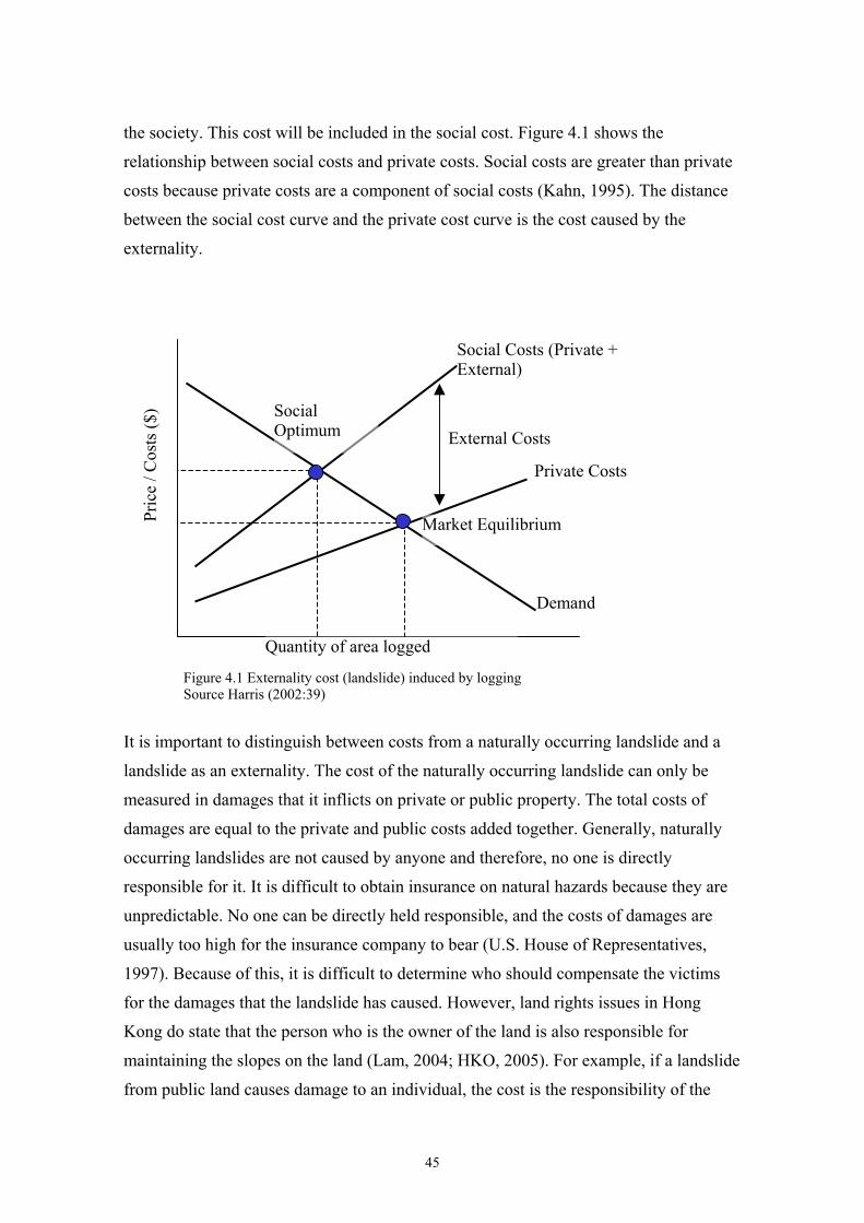
the society. This cost will be included in the social cost. Figure 4.1 shows the
relationship between social costs and private costs. Social costs are greater than private
costs because private costs are a component of social costs (Kahn, 1995). The distance
between the social cost curve and the private cost curve is the cost caused by the
externality.
Social Costs (Private + External)
Social Optimum
Pric
e / C
osts
($)
External Costs Private Costs
It is important to distinguish between costs from a naturally occurring landslide and a
landslide as an externality. The cost of the naturally occurring landslide can only be
measured in damages that it inflicts on private or public property. The total costs of
damages are equal to the private and public costs added together. Generally, naturally
occurring landslides are not caused by anyone and therefore, no one is directly
responsible for it. It is difficult to obtain insurance on natural hazards because they are
unpredictable. No one can be directly held responsible, and the costs of damages are
usually too high for the insurance company to bear (U.S. House of Representatives,
1997). Because of this, it is difficult to determine who should compensate the victims
for the damages that the landslide has caused. However, land rights issues in Hong
Kong do state that the person who is the owner of the land is also responsible for
maintaining the slopes on the land (Lam, 2004; HKO, 2005). For example, if a landslide
from public land causes damage to an individual, the cost is the responsibility of the
Quantity of area logged
Market Equilibrium
Demand
Figure 4.1 Externality cost (landslide) induced by logging Source Harris (2002:39)
45
government. In this case, it is fascinating to discuss the motives of the public to prevent
and protect themselves from landslides, if they are not held responsible. In other words,
if government is responsible for landslides in a hilly area with residents, the residents
will not have an incentive to support a public good of a prevention method. This is
because the residents would be compensated for their losses by the government in a
case of a landslide. They might even be encouraged to move to a landslide-prone area,
so as to take advantage of the compensation.
4.1.2.2 Distinction between Public and Social Costs
When reviewing the cost of a landslide as an externality, costs from the whole action is
measured. These are the private costs to the firm, the cost of the externality, which is the
landslide. These two components form the social cost. Social cost is not the same as a
public cost mentioned in the costs of natural hazards. ‘Public cost’ was used instead of
‘Social cost’ to distinguish between the two different concepts of cost. Social cost is
seen as a general cost to the whole society instead of a public cost, which is a monetary
loss to the government. In theory, Private cost is a loss to the individual but also a cost
to the society because it is not a benefit. Therefore, the private costs and the costs that
the externality causes, forms the social cost.
46
4.2 Responsibility of the External Costs
When a landslide is treated as an externality, it is relatively easier to determine which
party is to be held responsible for the costs incurred. This argument is based on the
concept of ‘polluter’ and ‘victim’. The ‘polluter’ refers to the party who performed a
certain act, which resulted in an externality, whereas the ‘victim’ is the party who
suffers from this externality. Usually, compensation issues between the polluters and the
victims are determined by the ownership of the land. However, Coase Theorem argues
that a mutually beneficial agreement would be reached between both parties, regardless
of the land rights.
4.2.1 Coase Theorem
Ronald H. Coase invented Coase Theorem in 1960 from which he won the Nobel Peace
Price in 1991. His theory argued against A.C. Pigou, who stated that externalities could
not be mitigated without direct action by the government in the form of taxes against the
polluter (Harris, 2002). This was the 'polluter pays' principle. The Coase Theorem,
however, argues that in the absence of transaction costs, the market will generate the
optimal level of externalities, regardless of who owns the property rights. This is
because the interested parties will bargain privately to correct any externality. In other
words, a social benefit will be reached when the parties negotiate an agreement that will
be a gain for both. Perman et al (2003) states that, “given a suitable assignment of
property rights, private bargaining between individuals can correct externality
problems and lead to efficient outcomes”.
4.2.1.1 Coase Theorem Explained Through a Landslide Example
Coase Theorem is most effectively explained through an example. In this example,
landslides are seen as the externality caused by logging. The 'polluter' causes the
externality, which harms the 'victim' with damages to his or her property. Suppose a
logging company is cutting trees from their property on top of a hill. At the bottom of
that hill, there is a lake, which provides clean drinking water for the area and supports
47
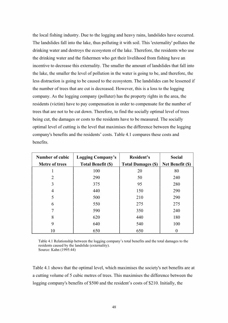
the local fishing industry. Due to the logging and heavy rains, landslides have occurred.
The landslides fall into the lake, thus polluting it with soil. This 'externality' pollutes the
drinking water and destroys the ecosystem of the lake. Therefore, the residents who use
the drinking water and the fishermen who get their livelihood from fishing have an
incentive to decrease this externality. The smaller the amount of landslides that fall into
the lake, the smaller the level of pollution in the water is going to be, and therefore, the
less distraction is going to be caused to the ecosystem. The landslides can be lessened if
the number of trees that are cut is decreased. However, this is a loss to the logging
company. As the logging company (polluter) has the property rights in the area, the
residents (victim) have to pay compensation in order to compensate for the number of
trees that are not to be cut down. Therefore, to find the socially optimal level of trees
being cut, the damages or costs to the residents have to be measured. The socially
optimal level of cutting is the level that maximises the difference between the logging
company's benefits and the residents’ costs. Table 4.1 compares these costs and
benefits.
Number of cubic Logging Company’s Resident’s Social Metre of trees Total Benefit ($) Total Damages ($) Net Benefit ($)
1 100 20 80 2 290 50 240 3 375 95 280 4 440 150 290 5 500 210 290 6 550 275 275 7 590 350 240 8 620 440 180 9 640 540 100 10 650 650 0
Table 4.1 Relationship between the logging company’s total benefits and the total damages to the residents caused by the landslide (externality). Source: Kahn (1995:44)
Table 4.1 shows that the optimal level, which maximises the society's net benefits are at
a cutting volume of 5 cubic metres of trees. This maximises the difference between the
logging company's benefits of $500 and the resident’s costs of $210. Initially, the
48
logging company is going to be cutting 10 cubic metres of trees. However, the residents
are going to protest against this decision and are willing to pay compensation for the
lost benefits due to the decrease in the number of cubic metres of trees being cut. The
residents realise that the 10th cubic metre of trees is causing $110 of damages but
generating only $10 of benefits to the logging company. The residents can offer a
compensation of more than $10 but less than $110 to the logging company to reduce
their number of cubic metres of trees to 9. The logging company will have an incentive
to agree to the agreement, as the compensation for the decrease in cutting is more than
the value earned from cutting the trees. The negotiation process will continue until the
society's net benefits of cutting 5 cubic metres of trees is reached. At this level, the
residents are willing to pay to reduce the logging, as it is a benefit to both parties
involved. The level of trees being cut will not decrease under the level of 5 cubic
metres, as the residents decrease in costs would be smaller than the logging company's
benefits.
Coase argues that property right does not matter and the market forces will
automatically reach a mutual benefit in any case. Therefore, if the residents of the lake
have the land rights to the area where the logging is taking place, they would most
certainly ban the logging. However, the logging company would be willing to
compensate the residents for the landslides that they cause in cutting the forest.
Negotiations would take place and it will be determined that cutting one cubic metre of
trees would generate $100 benefits to the logging company, but cost of only $20 to the
residents. The logging company would pay a compensation sum of greater than $20 but
less than $100 to the residents. This again would give the residents an incentive to let
the logging company cut that amount of trees, as it is a mutual benefit for both parties
involved. The process would continue until the socially optimal level of 5 cubic metres
of trees would be reached. This proves that the same optimal level will be reached
regardless of who owns the property rights.
As the Coase Theorem believes that the market will automatically generate the optimal
level of an externality, it opposes Pigou's idea of government tax on the polluters. Coase
also believes that the Pigovian tax will encourage people to locate to areas where they
are prone to risk. The idea of placing oneself to risk would give an opportunity for the
residents to claim compensation for their possible suffering. Coase suggests that the
49
victim should be taxed in order to erase the incentive of taking advantage of
compensations (Kahn, 1995). In addition, people's willingness to pay for an area that is
prone to risks and pollution is greater as it is cheaper to live in, therefore, providing
residents with another incentive to move there. Coase argues that if the government is
not involved, an economically efficient equilibrium of costs and benefits will be reached
instead of bureaucratic organisations making the decisions based on political
preferences.
4.2.1.2 Shortcomings of Coase Theorem
However, the Coase Theorem has several weaknesses. Firstly, the compensation that is
needed for the externality to decrease might be too high for the victim to pay. In this
case, the Coase Theorem would fail. Also, some values are considered higher than the
value of money. As in the lake example described above, if the residents, who own the
land rights, feel that the lake is irreplaceable by any amount, and they want to preserve
it as natural as possible, then there will not be a transaction between the two parties.
Thirdly, the Coase Theorem states that transaction costs are insignificant. Coase only
takes into consideration two parties: the polluter and the victim. In a real-world
situation, there are multiple polluters and multiple victims with unequal share of
suffering and polluting among themselves. This would create high transaction costs that
would make the negotiations fail (Hussen, 2000). Lastly, when addressing global
pollution problems, which stretch beyond property rights and demand severe restrictions
on emissions and need the co-operation of all nations in the world, Coase Theorem
would be totally ineffective (Harris, 2002).
When reviewing damages from an externality, Coase Theorem provides a clear
framework of compensation between two parties. However, in today’s world, pollution
issues need to be controlled through strict rules and regulations. Coase Theorem
provides a clear compensation framework between two parties, which enables a
theoretical review of damages as an externality to be carried out. However, the
shortcomings of the Coase Theorem, in a city like Hong Kong, would make it only
work in theory. This is because the land is scarce and the population is large, therefore,
making it difficult to determine the roles of victims and polluters. As the pollution
50
affects the victims in different ways, it would also be difficult to determine the
appropriate compensations. Government intervention is therefore, the most appropriate
option for human induced landslides in cities like Hong Kong, as opposed to the over-
simplified Coase Theorem. It is also important to note that landslides are regarded as
externalities only when they derived from human-induced economic activities. The
Coase Theorem would not work, even in theory, in the case of costs from a natural
hazard. This is because there is only a 'victim' but no 'polluter'.
51
4.3 Government Intervention
Governments have great influence in controlling human actions in order to preserve the
environment. By setting standards, enforcing restrictions and creating awareness of the
importance of environment, government could have a positive impact in protecting the
environment. There are four classes of government intervention as suggested by Kahn
(1995): (1) moral suasion, (2) direct production of environmental quality, (3) command
and control regulations, and (4) economic incentives. Each of these interventions
represents a different idea or philosophy towards the role of government in the society,
generating changes through providing incentives to the polluters. These environmental
prevention methods should not be isolated into single methods but can also be viewed
as a combination of several of the above methods.
Moral suasion is a term used to describe the government’s attempts to influence the
public’s behaviour without rules or regulations. Governments use moral suasion by
organising publicity stunts, distributing advertisements and making statements of moral
behaviours. It is important in moral suasion to tell the public their change in behaviour
would lead to greater benefits than the costs. The common issues that are dealt with are
reducing waste, increasing recycling, preventing forest fires, maintaining slopes to
reduce landslides, et cetera. Moral suasion programs usually have a catchy slogan to
appeal to the public. For example, Woodsy Owl's “Give a hoot, don't pollute” (USDA,
1970, in Kahn, 1995). Moral suasion is a way to create people’s ethical responsibility to
the environments by changing their behaviours. Societal pressure in communities also
creates a moral responsibility to behave in the certain manner. This is another way to
get the public to behave in a morally and ethically correct way when discussing
environmental protection. Therefore, the more communities that are involved, the better
the results are for the environment (Field & Field, 2002).
52
4.3.1 Direct Production of Environmental Quality
Direct productions of environmental qualities are methods that the government carry out
to physically improve the environment. Through planting of trees and vegetation,
stocking of fish, treating sewage and cleaning up of toxic sites, the government can
improve the quality of the environment (Kahn, 1995). Some of these methods are
relatively small in scale and might seem unrealistic to have any impact on the
degradation of the environment, especially when comparing to greater problems such as
air pollution, depletion of the ozone layer and global warming. However, it is important
that environmental improvement is practised at all levels. A simple individual's effort of
planting a tree could have a huge positive effect on the environment as the efforts of the
2004 Nobel Peace price winner Wangari Maathai from Kenya proved (BBC, 2004).
4.3.2 Command and Control Regulations
Command and Control regulations are policy instruments set by the government that
restrict actions that degrade the environment. Command and Control regulations are
distinct from other policy instruments as they impose direct constraints on individuals,
or any other generators of externalities, on such behaviours. If individuals or
organisations do not comply with the regulations set by the government, they will be
penalised. The restrictions could be, for example, a ban on logging in natural
conservation areas, a ban on the use of certain fertilisers or pesticides, restrictions on
fishing stock, et cetera. Take the Philippines as an example; severe landslides killed
more than 1,100 people as a result of logging in December 2004. President Gloria
Macapagal-Arroyo has since banned all commercial logging. The suspension of logging
permits all over the country will protect the environment and prevent such disasters
from happening again (SCMP, 2004a). Unfortunately, illegal logging is a strong
industry in the Philippines, which continues the destruction of the abundant rainforests
in South-East Asia.
53
4.3.3 Economic Incentives
Economic incentives rely on different psychology as the Command and Control
regulations. Instead of restricting or banning certain actions, the economic incentives
offer compensation to the person to alter their behaviours for the benefits of the
environment. Economic incentives include pollution taxes, pollution subsidies,
marketable pollution permits and the deposit refund system. The European Union has
enforced multiple economic incentives to preserve the environment and landscaping of
Europe. Most of these incentives have fallen to farmers in the form of set aside of land,
subsidise the usage of fertilisers and pesticides, preservation of rural landscape, et
cetera.
Government has an enormous influence in protecting the environment. There are
several ways that the public’s actions can be altered into more environmentally friendly
methods, as discussed in the above section. The Government of Hong Kong, who is the
majority landowner, has made numerous decisions regarding the prevention and
responsibility of landslides. These actions will be discussed in details in the Hong Kong
example of Chapter five.
54
4.4 Cost-Benefit Analysis
As mentioned earlier, cost is usually at the heart of many decisions. Decisions for
establishing building codes for new construction, strengthening existing buildings, land-
use controls, and improving preparedness planning, stabilisation and protection methods
are generally determined by comparing costs and benefits (Coburn et al, 1994). The
decisions are based on a widely used environmental concept called Cost-benefit
analysis.
The Cost-benefit analysis is a natural resource and environmental decision-making tool
that involves measuring, adding up and comparing all the costs and benefits of a
particular project or program (Field & Field, 2002). There are four essential steps to the
cost-benefit analysis. These are: (1) specify clearly the project or program; (2) describe
quantitatively the inputs and outputs of the program; (3) estimate the social costs and
benefits of these inputs and outputs; and (4) compare these costs and benefits. Once the
costs and benefits of a particular project are estimated, a simple equation is carried out
to compare the costs to the benefits. The idea is that all the benefits of the project would
be computed in financial terms, with the costs then being deducted, and the difference
becomes the net value of the project. The equation is as follows:
Total benefits - Total costs = Net Value of a project
For example, a project with total benefits of $15 million and total costs of $8 million, its
net value would therefore be $15 million - $8 million = $ 7 million. Another way to
compare the costs and benefits could be by finding the cost-benefit ratio. This is a
simple ratio of costs and the amount of benefits produced per dollar of cost.
Total Costs / Total Benefits = Cost-benefit ratio
55
With the same example, the cost-benefit ratio would be $8 million / $15 million = 0.53.
In interpreting this ratio, the smaller the cost to benefit ratio, the more viable it is to
invest in a landslide protection or stabilisation method. This ratio can also be looked at
from the benefits to costs perspective. The greater the benefit-cost ratio is, the more
viable it is to carry out that particular project.
4.4.1 Cost-Benefit Analysis on Landslide Issues
Bennett & Doyle (1997) presented an equation to show the cost-benefit relationship in
the viability in a landslide prevention project:
Benefits / Costs = (Cd - Cd’) / Cp
In this equation, Cd is the predicted damage from the landslide, Cp is the cost of the
landslide protection or stabilisation method, which is necessary to limit or reduce the
cost to Cd’. Therefore, if the benefits outweigh the costs, then it is worthwhile to
implement a landslide protection or stabilisation method. Alternatively, if the costs were
higher compared to the benefits, the value for money could not be obtained. This might
happen when the amount of damage is small or when the investment required for
reducing the landslide is too large. The concept of cost-benefit analysis in the case of
hazards is illustrated in figures 4.2A and 4.2B.
56
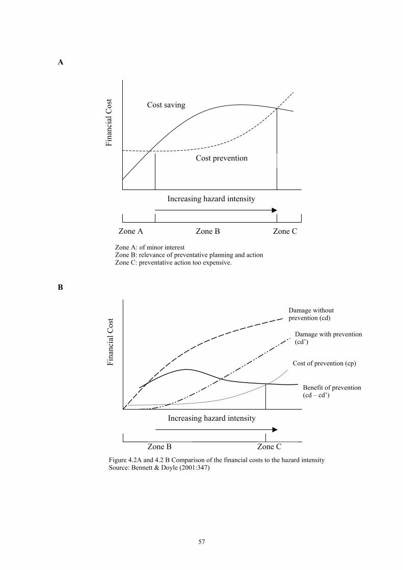
A
Fina
ncia
l Cos
t Cost saving
Cost prevention
Increasing hazard intensity
Zone A
B
Zone B Zone C
Zone A: of minor interestZone B: relevance of preventative planning and action Zone C: preventative action too expensive.
Damage without prevention (cd)
Fina
ncia
l Cos
t
Damage with prevention (cd’)
Increasing hazard intensity
Zone B Zone C
Cost of prevention (cp)
Benefit of prevention(cd – cd’)
Figure 4.2A and 4.2 B Comparison of the financial costs to the hazard intensity Source: Bennett & Doyle (2001:347)
57
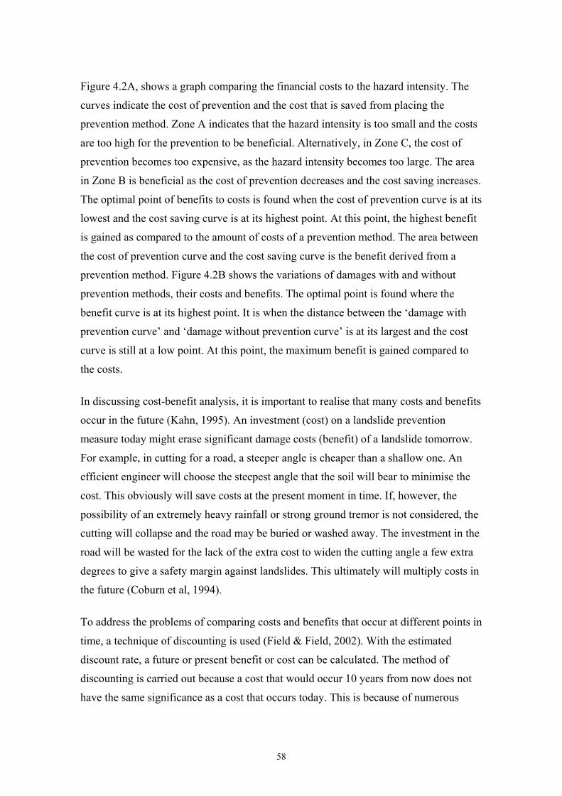
Figure 4.2A, shows a graph comparing the financial costs to the hazard intensity. The
curves indicate the cost of prevention and the cost that is saved from placing the
prevention method. Zone A indicates that the hazard intensity is too small and the costs
are too high for the prevention to be beneficial. Alternatively, in Zone C, the cost of
prevention becomes too expensive, as the hazard intensity becomes too large. The area
in Zone B is beneficial as the cost of prevention decreases and the cost saving increases.
The optimal point of benefits to costs is found when the cost of prevention curve is at its
lowest and the cost saving curve is at its highest point. At this point, the highest benefit
is gained as compared to the amount of costs of a prevention method. The area between
the cost of prevention curve and the cost saving curve is the benefit derived from a
prevention method. Figure 4.2B shows the variations of damages with and without
prevention methods, their costs and benefits. The optimal point is found where the
benefit curve is at its highest point. It is when the distance between the ‘damage with
prevention curve’ and ‘damage without prevention curve’ is at its largest and the cost
curve is still at a low point. At this point, the maximum benefit is gained compared to
the costs.
In discussing cost-benefit analysis, it is important to realise that many costs and benefits
occur in the future (Kahn, 1995). An investment (cost) on a landslide prevention
measure today might erase significant damage costs (benefit) of a landslide tomorrow.
For example, in cutting for a road, a steeper angle is cheaper than a shallow one. An
efficient engineer will choose the steepest angle that the soil will bear to minimise the
cost. This obviously will save costs at the present moment in time. If, however, the
possibility of an extremely heavy rainfall or strong ground tremor is not considered, the
cutting will collapse and the road may be buried or washed away. The investment in the
road will be wasted for the lack of the extra cost to widen the cutting angle a few extra
degrees to give a safety margin against landslides. This ultimately will multiply costs in
the future (Coburn et al, 1994).
To address the problems of comparing costs and benefits that occur at different points in
time, a technique of discounting is used (Field & Field, 2002). With the estimated
discount rate, a future or present benefit or cost can be calculated. The method of
discounting is carried out because a cost that would occur 10 years from now does not
have the same significance as a cost that occurs today. This is because of numerous
58
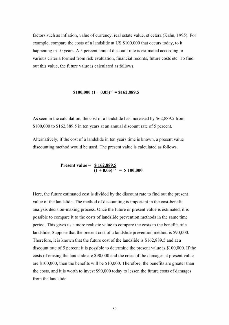
factors such as inflation, value of currency, real estate value, et cetera (Kahn, 1995). For
example, compare the costs of a landslide at US $100,000 that occurs today, to it
happening in 10 years. A 5 percent annual discount rate is estimated according to
various criteria formed from risk evaluation, financial records, future costs etc. To find
out this value, the future value is calculated as follows.
$100,000 (1 + 0.05)¹° = $162,889.5
As seen in the calculation, the cost of a landslide has increased by $62,889.5 from
$100,000 to $162,889.5 in ten years at an annual discount rate of 5 percent.
Alternatively, if the cost of a landslide in ten years time is known, a present value
discounting method would be used. The present value is calculated as follows.
Present value = $ 162,889.5 (1 + 0.05)¹° = $ 100,000
Here, the future estimated cost is divided by the discount rate to find out the present
value of the landslide. The method of discounting is important in the cost-benefit
analysis decision-making process. Once the future or present value is estimated, it is
possible to compare it to the costs of landslide prevention methods in the same time
period. This gives us a more realistic value to compare the costs to the benefits of a
landslide. Suppose that the present cost of a landslide prevention method is $90,000.
Therefore, it is known that the future cost of the landslide is $162,889.5 and at a
discount rate of 5 percent it is possible to determine the present value is $100,000. If the
costs of erasing the landslide are $90,000 and the costs of the damages at present value
are $100,000, then the benefits will be $10,000. Therefore, the benefits are greater than
the costs, and it is worth to invest $90,000 today to lessen the future costs of damages
from the landslide.
59
It is important to note that discount rates is a theoretical tool used to calculate possible
prices, costs and benefits of the future. Interest rates, inflation, currency value, real
estate prices, et cetera, are unpredictable and the exact value of the future is impossible
to estimate (Kahn, 1995). However, the discounting of the cost-benefit analysis does
provide a general average cost or benefit of the future. It also provides a present value
that can be used as an estimate in projects.
60
4.5 Willingness to Pay
The costs and benefits of landslides were discussed above as according to the possible
damages that they could cause. This was done by estimating the costs of a landslide by
risk assessment, cost-benefit analysis and discounting. The cost associated with
landslides also includes the protection and stabilisation methods that need to be invested
upon to reduce the possible damages that might be caused.
The value of landslides can also be measured with a concept of ‘willingness to pay’.
This environmental economic theory is commonly used to measure human preferences,
which is then placed to measure the value of an environmental amenity (Kahn, 1995).
Environmental quality, for instance, could be an aesthetic or a recreational reason, such
as fresh air, clean water, nice view and wildlife, et cetera. The value of this good is
measured by what the person is willing and able to make sacrifice for. Therefore, the
value of the good, in monetary terms, is the amount, which the person is willingness to
pay for (Field & Field, 2002). This method is a way of measuring the social value of the
good according to the public and their opinions by placing a financial value to it.
Willingness to pay is a question of individual values. Others are willing to pay for a
quiet living environment, or to preserve natural wildlife, whilst others are not.
Willingness to pay also has a lot to do with a person’s wealth and economic standard.
Therefore, ‘the ability to pay’ for certain goods also determines their ‘willingness to
pay’. There are two main methods of calculating people's willingness to pay. These are
by using the direct and indirect techniques (Kahn, 1995; Field & Field, 2002).
4.5.1 Direct Technique
Direct techniques value the measures of environmental resources or quality by asking
individuals hypothetical questions. There are two main direct techniques: contingent
valuation and conjoint analysis. Contingent valuation method is based on asking an
individual to state his or her willingness to pay to bring about environmental
improvement. For example, improved visibility from lessened air pollution, protection
of an endangered species, or the preservation of a wilderness area (Harris, 2002). The
questions can be open-ended or close-ended. Open-ended questions ask the interviewed
61
individuals to state their maximum willingness to pay for improvements on a certain
environmental quality. Alternatively, close-ended questions ask whether the individuals
will be willing to pay for certain environmental quality or resources.
The second direct technique used is conjoint analysis, which determines the individual's
preferences between different environmental qualities and conditions (Kahn, 1995).
Conjoint analysis allows individuals to mark their preferences between different
environmental problems, or to a certain environmental problem with different
characteristics. With the assumption that resources are given into a particular
environmental problem, individuals would be asked to rank their preferences only on
issues regarding that problem. As it is assumed that money or resources are fixed and
devoted into the problem, no trade-offs between the environment and money would
have to be made.
When direct techniques are adopted into the dilemma associated with landslides, the
value of risk is calculated. Risk is the driving force of people's willingness to pay, either
by erasing it or avoiding it. Contingent valuation, in this case, would ask the residents
their maximum willingness to pay for preventing a landslide. This depends entirely on
the individual’s perception of the dangers of the landslide to his or her property and life.
In other words, the exact location of your house could alter your decision. For example,
a person who lives right below a steep hill has an incentive to support a landslide
prevention method; as contrast to a person who does not live close to the hill, as he is
not under threat from landslides. On the other hand, conjoint analysis in the example of
landslides would ask the individual which type of landslide prevention method should
be used. As the funds have already been dedicated to erase the risks, the individual’s
choice is on how to deal with the risks. For example, imagine a public area being
classified as a dangerous site due to frequent landslide activities. The residents are given
a choice of how they would use their compensation funds. The contingent analysis
would ask if the individual would like to spend the funds on a prevention method, on
insurance of the house and lives or to relocate to a new area without landslides. The
conjoint analysis could also ask which prevention method they prefer. The individuals
would be given a number of alternatives, such as the aesthetic qualities or safety, et
cetera, in which they would rank their preferences. These individual’s choices create a
value for the landslide as people choose what is important and what is not.
62
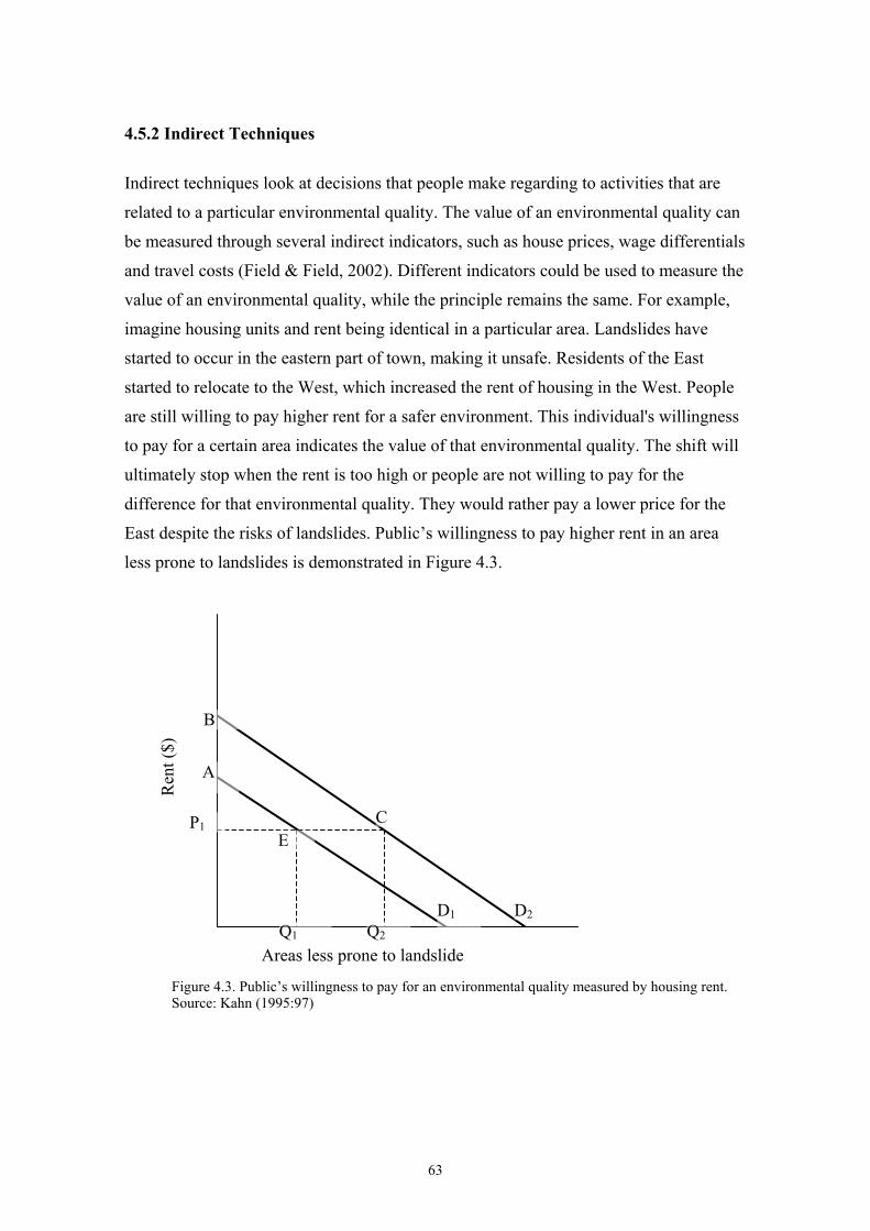
4.5.2 Indirect Techniques
Indirect techniques look at decisions that people make regarding to activities that are
related to a particular environmental quality. The value of an environmental quality can
be measured through several indirect indicators, such as house prices, wage differentials
and travel costs (Field & Field, 2002). Different indicators could be used to measure the
value of an environmental quality, while the principle remains the same. For example,
imagine housing units and rent being identical in a particular area. Landslides have
started to occur in the eastern part of town, making it unsafe. Residents of the East
started to relocate to the West, which increased the rent of housing in the West. People
are still willing to pay higher rent for a safer environment. This individual's willingness
to pay for a certain area indicates the value of that environmental quality. The shift will
ultimately stop when the rent is too high or people are not willing to pay for the
difference for that environmental quality. They would rather pay a lower price for the
East despite the risks of landslides. Public’s willingness to pay higher rent in an area
less prone to landslides is demonstrated in Figure 4.3.
B
Ren
t ($)
A
CP1 E
Figure 4.3. Public’s willingness to pay for an environmental quality measured by housing rent.Source: Kahn (1995:97)
Q1 Q2
D D1 2
Areas less prone to landslide
63
Figure 4.3 is based on the travel cost method proposed by Harold Hotelling in 1947.
Instead of measuring people's willingness to pay for improved environmental quality,
the increased rent of housing in respect to the probability of landslides is adopted. The
two cost demand curves represent people’s willingness to pay for the rent in the area
without landslide prevention methods (D1) and an area with landslides prevention
methods (D2). P1 represents the average rent of a house in both areas. The area with
landslide prevention methods is going to attract more residents, as people feel safer
from the risks associated with landslides. Therefore, the number of residents is going to
increase from Q1 to Q2. The value of the prevention of landslides is, therefore, the area
of ABCE, for which people are willing to pay extra costs.
Figure 4.3 does not take into consideration the increased rent of the area with landslide
prevention methods, as compared to the area without the landslide prevention methods.
This would ultimately lead to the rent of housing being too high, comparing to the risks
caused by landslides. People would choose to live in the cheaper area and suffer the
consequences that might derive from a landslide. Also, the rise in population will
increase the rent of the houses, as mentioned previously. However, the concept of
willingness to pay is a good way for measuring the value of an improved environmental
quality. In this case, it refers to the decrease from landslides by implementing a
landslide prevention method.
4.5.3 Valuation of Benefits
Willingness to pay can also be used to measure social benefits. If a regulation or project
is proposed to improve the environmental quality, which people are willing to pay for, it
is a social gain. This environmental project could be, for example, the reduction of
sulphur emissions by the government (Hussen, 2000). In other words, if a landslide
prevention method is placed to protect the public, it decreases the amount of landslides,
or at least reduces the damages that they cause. This reduces the risk and increases
people’s safety, therefore, improving their quality of life. The decision for a landslide
prevention method is a form of government intervention that leads to social benefits.
This benefit can be measured by using a demand curve as shown in figure 4.4.
64
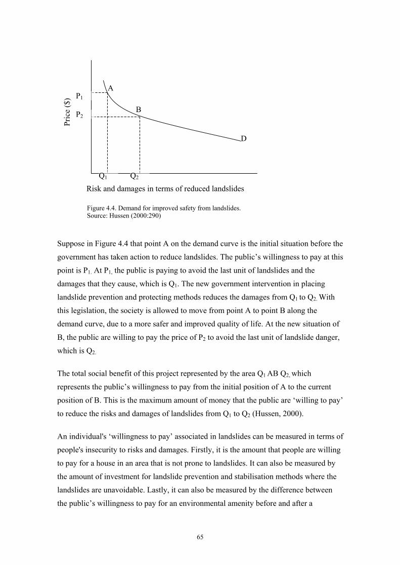
A P1
Pric
e ($
)
B P2
D
Suppose in Figure 4.4 that point A on the demand curve is the initial situation before the
government has taken action to reduce landslides. The public’s willingness to pay at this
point is P1. At P1, the public is paying to avoid the last unit of landslides and the
damages that they cause, which is Q1. The new government intervention in placing
landslide prevention and protecting methods reduces the damages from Q1 to Q2. With
this legislation, the society is allowed to move from point A to point B along the
demand curve, due to a more safer and improved quality of life. At the new situation of
B, the public are willing to pay the price of P2 to avoid the last unit of landslide danger,
which is Q2.
The total social benefit of this project represented by the area Q1 AB Q2, which
represents the public’s willingness to pay from the initial position of A to the current
position of B. This is the maximum amount of money that the public are ‘willing to pay’
to reduce the risks and damages of landslides from Q1 to Q2 (Hussen, 2000).
An individual's ‘willingness to pay’ associated in landslides can be measured in terms of
people's insecurity to risks and damages. Firstly, it is the amount that people are willing
to pay for a house in an area that is not prone to landslides. It can also be measured by
the amount of investment for landslide prevention and stabilisation methods where the
landslides are unavoidable. Lastly, it can also be measured by the difference between
the public’s willingness to pay for an environmental amenity before and after a
Risk and damages in terms of reduced landslidesQ Q1 2
Figure 4.4. Demand for improved safety from landslides.Source: Hussen (2000:290)
65

government intervention. Contingent valuation and conjoint analysis investigates the
value of landslide through questions. The individuals are asked questions of how much
they are willing to pay to erase the danger, or how the funds should be used to erase the
danger.
In the following chapter, Hong Kong will be specifically looked at in relation to
landslides, their history, risks associated with landslides, their causes, policies and
methods that are adopted to mitigate them. Finally, a case of a landslide that occurred in
Kwai Chung on the 16 June 1993 will be reviewed.
66
Chapter V
Landslides in Hong Kong
In this chapter, landslides in Hong Kong will be specifically examined. The issues that
have been discussed in the previous chapters will now be applied to examples in Hong
Kong. Landslides and ways of reducing them will be looked at, focussing on prevention
methods and government intervention. The risks associated with landslides will also be
analysed, taking into consideration the small and densely populated land area of Hong
Kong.
5.0 Introduction
Hong Kong is situated at the east of the estuary of the Pearl River of the People's
Republic of China. The small territory of 1,075 sq km is one of the most densely
populated urban areas worldwide, with a population of approximately 6.9 million (CIA,
2005). The area comprises of the main island of Hong Kong, peninsula of Kowloon,
New Territories and more than 230 islands with natural steep terrain and hills. The
upper slopes are steeper than 30°. The majority of the population is concentrated mainly
along the less steep urban areas on both sides of the Victoria Harbour. However, the
urban area is rapidly spreading upslope to hills and on water in the form of land
reclamation (Moy, 2004). Figure 5.1 shows the map of Hong Kong and its territories.
67
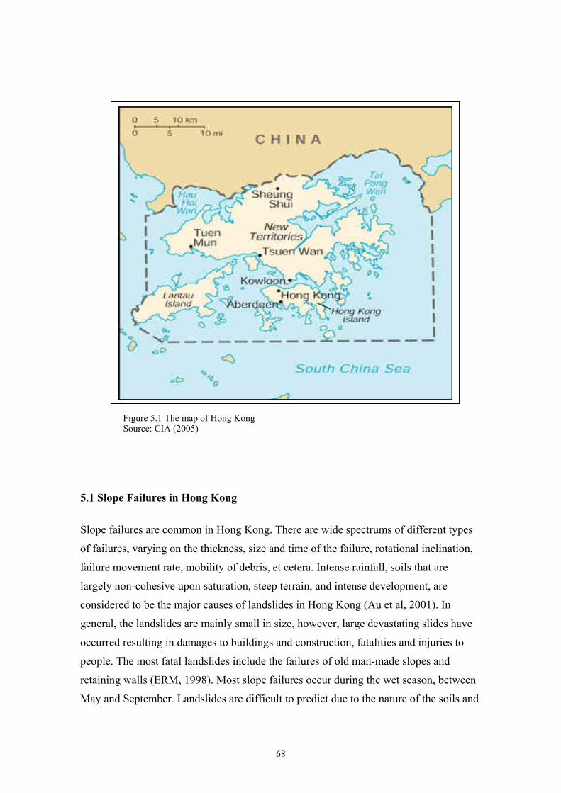
Figure 5.1 The map of Hong KongSource: CIA (2005)
5.1 Slope Failures in Hong Kong
Slope failures are common in Hong Kong. There are wide spectrums of different types
of failures, varying on the thickness, size and time of the failure, rotational inclination,
failure movement rate, mobility of debris, et cetera. Intense rainfall, soils that are
largely non-cohesive upon saturation, steep terrain, and intense development, are
considered to be the major causes of landslides in Hong Kong (Au et al, 2001). In
general, the landslides are mainly small in size, however, large devastating slides have
occurred resulting in damages to buildings and construction, fatalities and injuries to
people. The most fatal landslides include the failures of old man-made slopes and
retaining walls (ERM, 1998). Most slope failures occur during the wet season, between
May and September. Landslides are difficult to predict due to the nature of the soils and
68
the heavy rainfall. The reasons for slope failure in Hong Kong will be discussed as
follows.
5.1.1 Topography and Geology
Hong Kong’s topography is mainly hilly and mountainous with steep slopes. It has a
rugged terrain with hills rising steeply from the sea with slopes of 15° to 35°.Hong
Kong’s highest peak is at 957m in Tai Mo Shan, New Territories. On Lantau Island,
which is the largest land area in Hong Kong at 144 sq km, the terrain rises to 934m on
Lantau Peak and 930m on Sunset Peak. In Kowloon, the Kowloon Peak rises to 602 m.
Hong Kong Island is surrounded with narrow coastal strips, with a range of sharp peaks
rising steeply from the sea. Victoria peak is in the west at 547m and Mt. Parker is in the
east at 515m (CIA, 2005). From the peaks, ravines and gullies plunge down through
shrub land and woodland. The lowlands of the Hong Kong region, include floodplains,
river valleys, and reclaimed land, which occupy less than one-fifth of the land.
Extensive lowland regions are found only north of Mount Tai Mo, in the Yuen Long
and Sheung Shui plains.
5.1.2 Demography and Urban Area
Hong Kong’s population of 6.9 million is mainly concentrated at the northern part of
Hong Kong Island, Kowloon and some centres in the New Territories. The heavily
populated area reaches up to 150m above sea level on Hong Kong Island. Even though
Hong Kong is one of the most densely populated cities in the world, only about 22% of
the total land area of the territory is developed. It is the scarcity of flat habitable land
that is causing problems. The expansion of the urban area has added steepness to the
slopes by cutting and filling. These vast developments have since caused problems of
slope instability. In addition, buildings have been constructed upslope due to the lack of
space. This can lead to serious consequences as the damages from a possible landslide
increase. Human alterations on slope by cuttings and fill embankments are steeper than
the natural slopes of Hong Kong. Soil cut slopes and fill embankments are at angles of
69
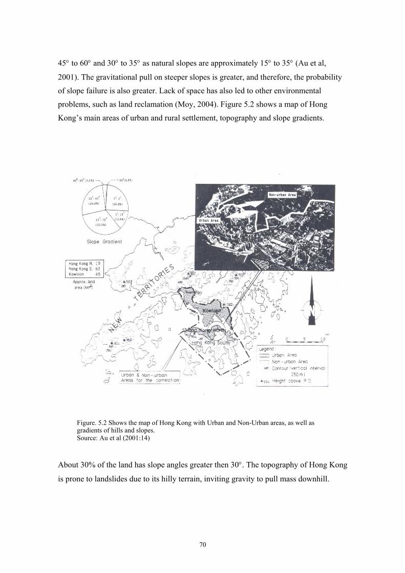
45° to 60° and 30° to 35° as natural slopes are approximately 15° to 35° (Au et al,
2001). The gravitational pull on steeper slopes is greater, and therefore, the probability
of slope failure is also greater. Lack of space has also led to other environmental
problems, such as land reclamation (Moy, 2004). Figure 5.2 shows a map of Hong
Kong’s main areas of urban and rural settlement, topography and slope gradients.
Figure. 5.2 Shows the map of Hong Kong with Urban and Non-Urban areas, as well as gradients of hills and slopes. Source: Au et al (2001:14)
About 30% of the land has slope angles greater then 30°. The topography of Hong Kong
is prone to landslides due to its hilly terrain, inviting gravity to pull mass downhill.
70

5.1.3 Geology
The geology of Hong Kong is constructed mainly out of three rock types; the
sedimentary rocks, granites and the volcanic rocks. The sedimentary rocks are not as
important as the others when reviewing landslides, since they are situated in the low-
lying areas of Hong Kong (ERM, 1998). The granites and volcanic rocks, however, are
situated on higher ground and are prone to failure. Figure 5.3 shows a map of the types
of rocks distributed in Hong Kong.
Figure 5.3 Map of the main types of rock types distributed in areas of Hong Kong. Source: Au et al (2001:17)
Coarse-grained granite rocks are found in Kowloon, the central part of Hong Kong
Island, and the lower levels of Victoria peak. Alternatively, finer-grained volcanic rocks
can be found in the middle and upper levels of Victoria Peak, the southern part of Hong
Kong Island and much of the New Territories (ERM, 1998). The soils derived from
granites are usually sandy, while those that derive from volcanic rocks tend to be silty.
The granites and volcanic rocks that are found in the more hilly areas are both seriously
weathered by heavy rains. However, the granite rocks tend to be weathered more deeply
than the volcanic rocks. The weathering depth of volcanic rocks is no more than 30
71
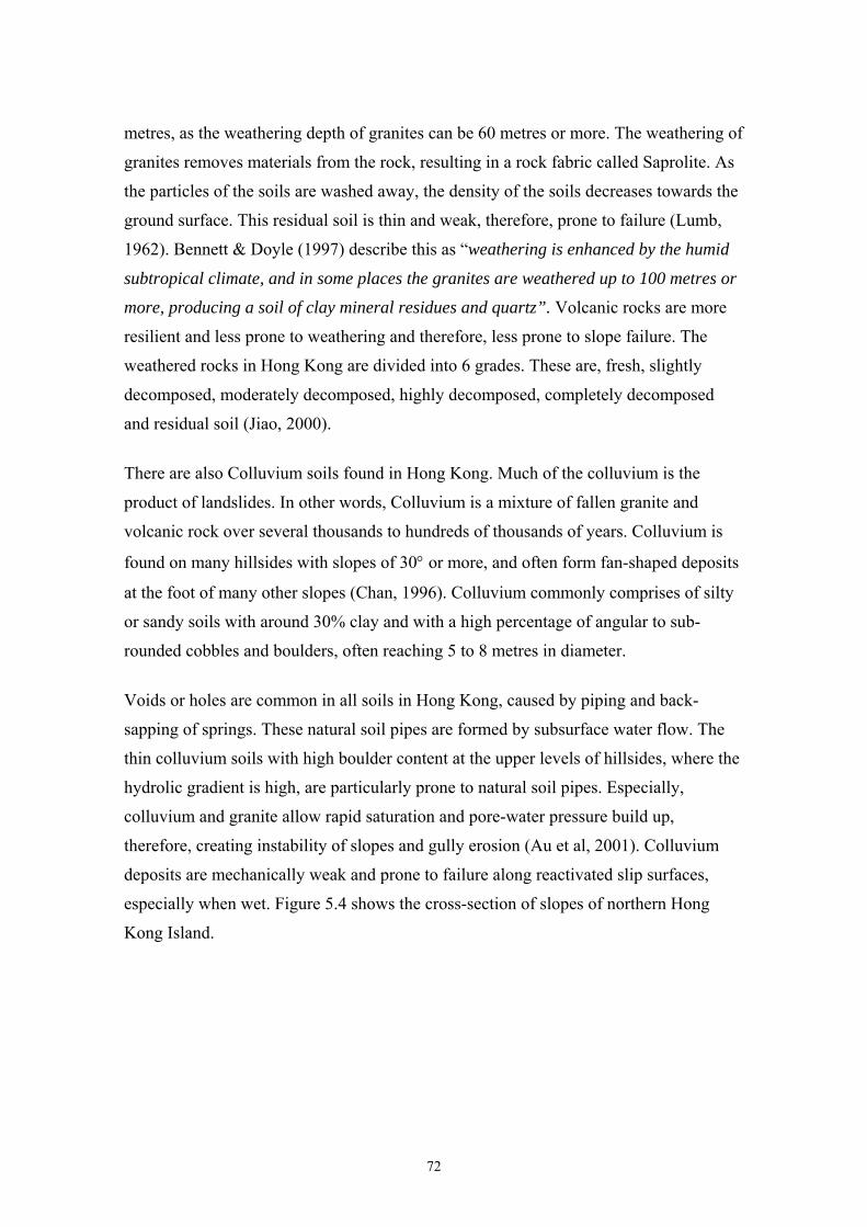
metres, as the weathering depth of granites can be 60 metres or more. The weathering of
granites removes materials from the rock, resulting in a rock fabric called Saprolite. As
the particles of the soils are washed away, the density of the soils decreases towards the
ground surface. This residual soil is thin and weak, therefore, prone to failure (Lumb,
1962). Bennett & Doyle (1997) describe this as “weathering is enhanced by the humid
subtropical climate, and in some places the granites are weathered up to 100 metres or
more, producing a soil of clay mineral residues and quartz”. Volcanic rocks are more
resilient and less prone to weathering and therefore, less prone to slope failure. The
weathered rocks in Hong Kong are divided into 6 grades. These are, fresh, slightly
decomposed, moderately decomposed, highly decomposed, completely decomposed
and residual soil (Jiao, 2000).
There are also Colluvium soils found in Hong Kong. Much of the colluvium is the
product of landslides. In other words, Colluvium is a mixture of fallen granite and
volcanic rock over several thousands to hundreds of thousands of years. Colluvium is
found on many hillsides with slopes of 30° or more, and often form fan-shaped deposits
at the foot of many other slopes (Chan, 1996). Colluvium commonly comprises of silty
or sandy soils with around 30% clay and with a high percentage of angular to sub-
rounded cobbles and boulders, often reaching 5 to 8 metres in diameter.
Voids or holes are common in all soils in Hong Kong, caused by piping and back-
sapping of springs. These natural soil pipes are formed by subsurface water flow. The
thin colluvium soils with high boulder content at the upper levels of hillsides, where the
hydrolic gradient is high, are particularly prone to natural soil pipes. Especially,
colluvium and granite allow rapid saturation and pore-water pressure build up,
therefore, creating instability of slopes and gully erosion (Au et al, 2001). Colluvium
deposits are mechanically weak and prone to failure along reactivated slip surfaces,
especially when wet. Figure 5.4 shows the cross-section of slopes of northern Hong
Kong Island.
72
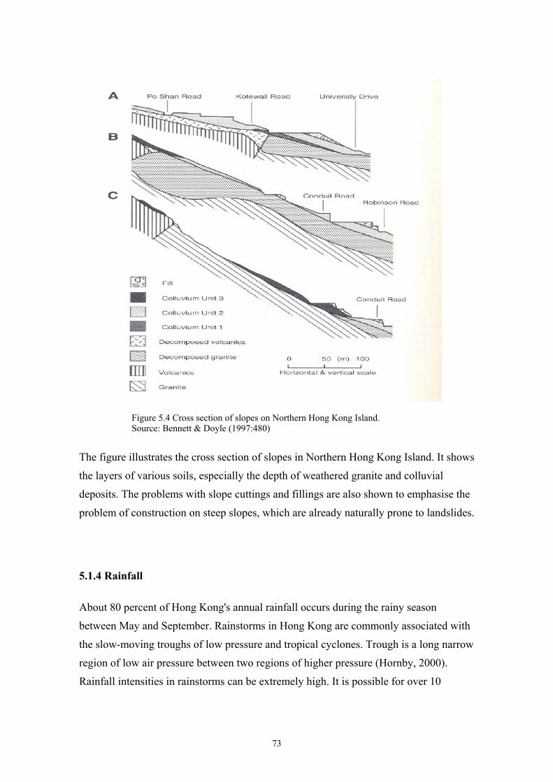
Figure 5.4 Cross section of slopes on Northern Hong Kong Island. Source: Bennett & Doyle (1997:480)
The figure illustrates the cross section of slopes in Northern Hong Kong Island. It shows
the layers of various soils, especially the depth of weathered granite and colluvial
deposits. The problems with slope cuttings and fillings are also shown to emphasise the
problem of construction on steep slopes, which are already naturally prone to landslides.
5.1.4 Rainfall
About 80 percent of Hong Kong's annual rainfall occurs during the rainy season
between May and September. Rainstorms in Hong Kong are commonly associated with
the slow-moving troughs of low pressure and tropical cyclones. Trough is a long narrow
region of low air pressure between two regions of higher pressure (Hornby, 2000).
Rainfall intensities in rainstorms can be extremely high. It is possible for over 10
73
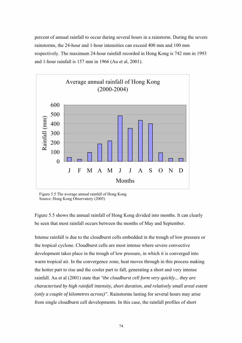
percent of annual rainfall to occur during several hours in a rainstorm. During the severe
rainstorms, the 24-hour and 1-hour intensities can exceed 400 mm and 100 mm
respectively. The maximum 24-hour rainfall recorded in Hong Kong is 742 mm in 1993
and 1-hour rainfall is 157 mm in 1966 (Au et al, 2001).
Average annual rainfall of Hong Kong (2000-2004)
0100200300400500600
J F M A M J J A S O N D
Months
Rai
nfal
l (m
m)
Figure 5.5 The average annual rainfall of Hong KongSource: Hong Kong Observatory (2005)
Figure 5.5 shows the annual rainfall of Hong Kong divided into months. It can clearly
be seen that most rainfall occurs between the months of May and September.
Intense rainfall is due to the cloudburst cells embedded in the trough of low pressure or
the tropical cyclone. Cloudburst cells are most intense where severe convective
development takes place in the trough of low pressure, in which it is converged into
warm tropical air. In the convergence zone, heat moves through in this process making
the hotter part to rise and the cooler part to fall, generating a short and very intense
rainfall. Au et al (2001) state that "the cloudburst cell form very quickly... they are
characterised by high rainfall intensity, short duration, and relatively small areal extent
(only a couple of kilometres across)”. Rainstorms lasting for several hours may arise
from single cloudburst cell developments. In this case, the rainfall profiles of short
74
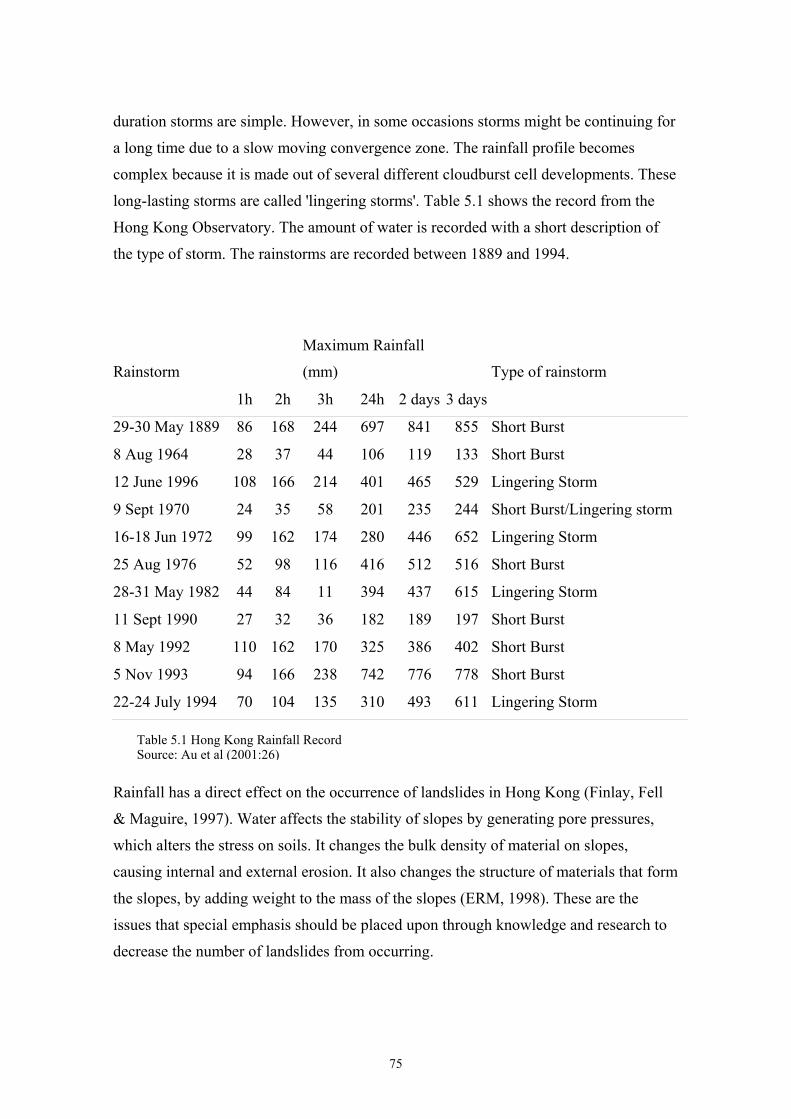
duration storms are simple. However, in some occasions storms might be continuing for
a long time due to a slow moving convergence zone. The rainfall profile becomes
complex because it is made out of several different cloudburst cell developments. These
long-lasting storms are called 'lingering storms'. Table 5.1 shows the record from the
Hong Kong Observatory. The amount of water is recorded with a short description of
the type of storm. The rainstorms are recorded between 1889 and 1994.
Rainstorm
Maximum Rainfall
(mm) Type of rainstorm
1h 2h 3h 24h 2 days 3 days
29-30 May 1889 86 168 244 697 841 855 Short Burst
8 Aug 1964 28 37 44 106 119 133 Short Burst
12 June 1996 108 166 214 401 465 529 Lingering Storm
9 Sept 1970 24 35 58 201 235 244 Short Burst/Lingering storm
16-18 Jun 1972 99 162 174 280 446 652 Lingering Storm
25 Aug 1976 52 98 116 416 512 516 Short Burst
28-31 May 1982 44 84 11 394 437 615 Lingering Storm
11 Sept 1990 27 32 36 182 189 197 Short Burst
8 May 1992 110 162 170 325 386 402 Short Burst
5 Nov 1993 94 166 238 742 776 778 Short Burst
22-24 July 1994 70 104 135 310 493 611 Lingering Storm
Table 5.1 Hong Kong Rainfall Record Source: Au et al (2001:26)
Rainfall has a direct effect on the occurrence of landslides in Hong Kong (Finlay, Fell
& Maguire, 1997). Water affects the stability of slopes by generating pore pressures,
which alters the stress on soils. It changes the bulk density of material on slopes,
causing internal and external erosion. It also changes the structure of materials that form
the slopes, by adding weight to the mass of the slopes (ERM, 1998). These are the
issues that special emphasis should be placed upon through knowledge and research to
decrease the number of landslides from occurring.
75
5.2 History of Landslides in Hong Kong
Hong Kong has a history of tragic landslides. In the 50 years after 1947, more than 470
people died, mostly as a result of failures associated with man-made cut slopes, fill
slopes and retaining walls. On top of casualties, these events could result in
considerable economic loss and disruptions to social activities. More than US$45
million (HK$350 million) of direct economic losses were reported due to tropical
cyclones, rainstorms, floods and landslides during the last ten years from 1994 to 2004
(Lam, 2004).
Hong Kong has had a steady and rapid population growth since the end of World War
II, along with major economic expansion. Between 1948 and 1977, the population
increased from 1.8 million to 4.6 million. Many new arrivals built huts on steep
hillsides, and where uncontrolled cutting and filling existed. During this period, there
was no fully effective system in place to control the geotechnical standards of land
development. Unfortunately, some of the earthworks of those days were not of a design
and construction that is sufficiently robust to cope with the severe rainstorms which
occurred during the wet season (CEDD, 2004). The result was frequent failures of man-
made slopes. On 18 June 1972 in Sau Mau Ping Estate in Kowloon, a 40m high road
embankment collapsed, killing 71 people. This was followed a few hours later by the
collapse of the hillside above a steep temporary excavation on Conduit Road in the
Mid-Levels area of Hong Kong Island which triggered a landslide that destroyed a 12-
storey residential building and killed 67 people. In 1976, another severe rainstorm hit
Hong Kong and brought down three fill slopes in Sau Mau Ping Estate again, which
were constructed without proper compaction. The resulting landslides killed 18 people.
The then Governor Sir Murray MacLehose immediately appointed an independent
review panel of international experts to study the problem and recommend a solution.
The panel recommended the establishment of a control organisation to regulate hillside
development and the design, construction and maintenance of slopes. This led to the
formation of a government geotechnical control body, the former Geotechnical Control
Office (now the GEO), in 1977.
76

Even today, although the risks to the community has been greatly reduced since the
formation of GEO, on average of about 300 incidents affecting man-made slopes, walls
and natural hillsides are reported to the Government each year.
Most of these incidents are minor; many are just washouts and erosion on the surfaces
of slopes and hillsides. However, significant proportions of the landslides are larger
failures, which can threaten life and property, block roads and disrupt the lives of the
community (CEDD, 2004).
77
5.3 Major Causes of Landslides in Hong Kong
5.3.1 Water in Soils
The role of water in slope stability is significant. Even though the soils of Hong Kong
are high in permeability, the shear intensity of the amount of rain could eventually cause
the soils to fall. These heavy rainstorms, in short bursts or lingering storms, cause an
enormous flood of water. The flood of water exceeds the rate at which water can
infiltrate into the soils. This causes a process called surface runoff (Rahardjo, Lee,
Leong & Razaur, 2004). Surface runoff is greater in soils, which are compact. Two
main types of slope covers are used in Hong Kong. These are the hard covers, shotcrete
or chunam covers, and the grass cover. The hardcovers have a larger surface runoff
compared to the grass cover. This is because it is more permeable and the intense
rooting helps in the suction process. (Premchitt et al, 1992, in Au et al, 2001). The
runoff is concentrated in the forms of flooding, channelling of flow, or a combination
depending on the surface features that the water encounters downhill. The features
include, natural valleys, man-made features and wild vegetation, et cetera (Au & Suen,
1996, in Au et al, 2001). Large volumes of running water of high velocity will cause
hydrolic scour, and will destroy and wash away protective covers of the slope (Au et al,
2001).
Channels of water also generate severe erosion of the soil mass, externally and
internally. Eventually, the shear force, which is pulled by gravity, will be stronger than
the resisting force, which has been weakened by water. The resisting force then
becomes unable to prevent the pull of gravity and collapses (Abbott, 2002). Landslides
usually occur during or shortly after rainfall. This is because in permeable soils, pore
water suction in the thin layer closest to the ground surface drops rapidly during rainfall
(Abdullah & Ali, 1993). The pore water pressure increases due to subsurface water flow
during the short bursts of rainfall. It is also one of the reasons for failure during or after
the rainstorm. “The main causes that rainwater affects slope stability have been
determined to be the loss of pore water suction, erosion and shallow pore water
pressure development” (Au et al, 2001).
78
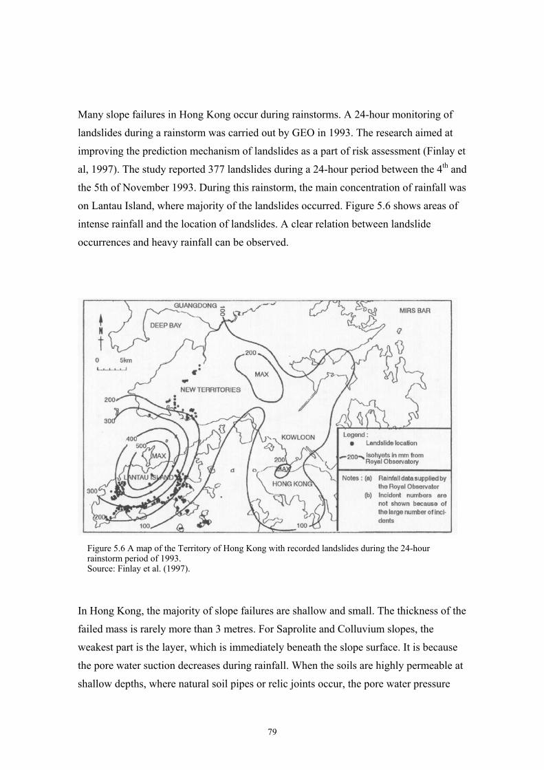
Many slope failures in Hong Kong occur during rainstorms. A 24-hour monitoring of
landslides during a rainstorm was carried out by GEO in 1993. The research aimed at
improving the prediction mechanism of landslides as a part of risk assessment (Finlay et
al, 1997). The study reported 377 landslides during a 24-hour period between the 4th and
the 5th of November 1993. During this rainstorm, the main concentration of rainfall was
on Lantau Island, where majority of the landslides occurred. Figure 5.6 shows areas of
intense rainfall and the location of landslides. A clear relation between landslide
occurrences and heavy rainfall can be observed.
Figure 5.6 A map of the Territory of Hong Kong with recorded landslides during the 24-hour rainstorm period of 1993. Source: Finlay et al. (1997).
In Hong Kong, the majority of slope failures are shallow and small. The thickness of the
failed mass is rarely more than 3 metres. For Saprolite and Colluvium slopes, the
weakest part is the layer, which is immediately beneath the slope surface. It is because
the pore water suction decreases during rainfall. When the soils are highly permeable at
shallow depths, where natural soil pipes or relic joints occur, the pore water pressure
79
caused by subsurface flow will also occur near the ground surface. This is also common
for soils, which are constructed of many layers, such as colluvium on the surface with
saprolite and volcanic rock underneath (Kirk, Campell, Fletcher & Merriman, 1997).
The soil layer closest to the surface is, therefore, most likely to fail. As the surface layer
is usually thin, thus, the failing mass is also relatively small. However, there are
exceptions. When the infiltration or subsurface flow extends to a greater depth, a larger
and thicker landslide could occur. This often happens on flatter slopes when heavy
lingering rainstorms occur. Moreover, if water can infiltrate deeper into the soils due to
the weak seams or relic joints, a thicker failed mass may occur. For example, on the 12th
and the 13th August 1995, two large landslides out of 70 other smaller ones occurred.
The first was at Fei Tsui Road in Chai Wan district, eastern Hong Kong Island, where
14,000m³ of debris fell. This landslide killed one person and injured another. The
second landslide at Shun Wan Road, Aberdeen, in southern Hong Kong Island, had the
volume of 26,000m³. This was the largest landslide in Hong Kong for 20 years and
caused 2 fatalities, 5 injuries and substantial damages to property (Kirk et al, 1997).
5.3.2 Urban Development
Approximately, half of the world’s population live in urban areas. Four-fifths of the
population growth in the 1990's has been in the cities. Population growth is seen as one
of the most influential global problems of the future. As population grows, great
pressure is being placed on arable land, water, energy, and biological resources to
provide an adequate supply of food while maintaining our ecosystem (Pimentel et al.
1999). Besides other environmental problems, urbanisation and population growth are
also major contributors to the occurrence of landslides (Chan, 1998). In urban areas,
landslides are caused by human actions, such as excavation and other forms of
construction works. These include, for example, mining and the construction of roads
and buildings, et cetera. When such unnatural processes are carried out the soil
structures become weaker and the ground gives way in the form of a landslide. In
addition, the weight of buildings and other structures tend to overload the slope, causing
it to fail. Other common human induced causes of landslides include the undercutting at
the base of the slope and mining explosions that break the bond, which holds the slope
80
together (Erickson, 2002). For example, in Guiyang, China, 23 people were killed by a
landslide caused by over-mining of the area (SCMP, 2004b; SCMP, 2004c).
In Hong Kong, all of the previously described causes of landslides apply. In addition,
the scarcity of land forces urbanisation to spread to the steep hillsides and the
reclamation of the sea-areas of Hong Kong. This increases the risks associated with
landslides. A landslide, for example, from Victoria peak down to Central Hong Kong
would have devastating consequences in terms of damages to infrastructure and human
lives. As the buildings are built on higher ground, they also would contribute to the
strength of the slide and the damages it would inflict downslope.
5.3.2.1 Land Reclamation
Due to the increased rate of population growth and rapid urban expansion, the problem
of land scarcity in Hong Kong is worsening. The level of flat land for settlement is very
limited as most of Hong Kong's landscape is hilly. This scarcity of land has led to a
dense centre with huge skyscrapers with soaring real estate prices. Hong Kong's
residential property prices increased by 180 percent in the early 90’s (Tse, 1993). As the
supply of land is limited, land use planning has become an important factor in making
suitable land available for specific uses. The need for additional land near urban areas
has led to the reclamation of land previously used for different purposes (Erickson,
2002).
In Hong Kong, land has been cleared to higher upslope for buildings to be built, making
them more prone to slope failures. As the dangers associated with all facilities and
buildings on hillsides were recognised by the government, it was realised that the
reclamation of water areas would provide more flat land and would decrease the risks
associated with building on slopes (Au et al, 2001). Especially, the reclamation of
Victoria Harbour, in Hong Kong has been common throughout its history. The
waterfront of Victoria Harbour between Central and Wan Chai has been continuously
reclaimed to increase the availability of land. With years of land reclamation, the Hong
Kong land area has increased from 1,060km³ in 1898, to 1102km³ in 2004. Hong Kong
Island itself expanded from 75km³ in 1842 to 78.33km³ today. The peak of reclamation
81
was between the 1960's to the 1980's, and in the 1990's, major projects of West
Kowloon and Chek Lap Kok took place in which, approximately 1,500 hectares of land
was created. There are several land reclamation projects taking place at the moment.
Central Reclamation Phase 3 project, reclaiming 18 hectares, started in February 2003
and will take approximately 60 months to complete. The estimated cost of the project is
HK$ 3.79 Billion. There are also plans for two major land reclamation projects of Wan
Chai 28.5 hectares and South East Kowloon, involving 133 hectares of land being
reclaimed (Moy, 2004).
The government has an important role in the decision making of land reclamation. Due
to its ownership of the majority of Hong Kong's land, it has the authority to approve any
land reclamation projects. Public auctions take place regularly to sell government
owned land to individuals who are willing to pay a high price. In recent years, the
government has put a lot of resources to develop new towns and their transportation
networks to alleviate this growing problem (Tse, 1993). The constant urban expansion
is not only causing increased environmental problems in the form of air pollution and
pollution of waterways. It also causes the increases in the number of landslides, as well
as any associated risks. Urban expansion upslope increases slope failure, as well as the
risk of more damages downslope.
5.3.3 Case Study of a Landslide in Hong Kong
On 16th June 1993, a landslide occurred at the crest of a cut slope adjacent to Cheung
Shan Estate bus terminal, Kwai Chung, New Territories. At the time a bus was parked
at the bus shelter in front of the cut slope. The landslide debris first hit a temporary shed
in front of the slope and then a bus further away. A woman at the bus shelter was killed
and five others were injured in the landslide.
The GEO carried out an investigation of the site. This included site surveys, collection
of documentary information, interview with a eyewitness, ground investigation, field
tests laboratory tests and consideration of the causes of the landslide. These findings are
summarised as follows.
82

5.3.3.1 The Site
The ground that failed on 16 June 1993 was the crest of a 15m high cut slope with a
shotcrete cover. During a construction of road network of Route 5 (Shin Mun Tunnel) in
the periods of 1987 and 1990, the area in front of the cut slope was turned into a bus
terminal.
5.3.3.2 Rainfall
According to the rainfall records, the first 15 days of June of 1993 were wet. Figure 5.7
shows a weather map of Hong Kong during that period.
Figure 5.7 The weather map of Hong Kong on 16 June 1993.
Source: GEO (1996)
Up to 16 June, a total of 383mm of rain was recorded by an automatic rain gauge. It was
situated about 0.5km southwest of the Cheung Shan Estate bus terminal. Rain was
heavy in the whole of the Territory on 16th June and a total of 200 mm of rain was
recorded. The peak hourly rainfall was about 79 mm between 11 am and noon. Figure
5.8 shows the rainfall recorded by a rain gauge at 5-minute intervals on 16 June 1993.
83
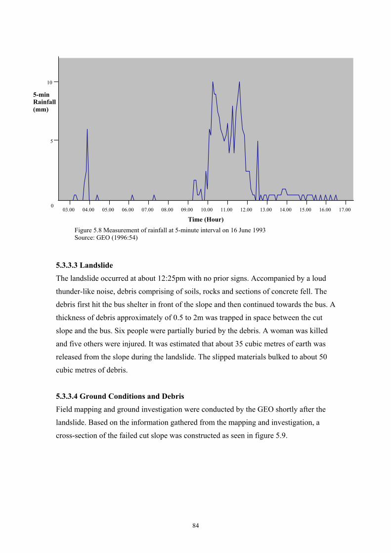
5-min Rainfall (mm)
10
5
0 03.00 04.00 05.00 06.00 07.00 08.00 09.00 10.00 11.00 12.00 13.00 14.00 15.00 16.00 17.00
Time (Hour) Figure 5.8 Measurement of rainfall at 5-minute interval on 16 June 1993
Source: GEO (1996:54)
5.3.3.3 Landslide
The landslide occurred at about 12:25pm with no prior signs. Accompanied by a loud
thunder-like noise, debris comprising of soils, rocks and sections of concrete fell. The
debris first hit the bus shelter in front of the slope and then continued towards the bus. A
thickness of debris approximately of 0.5 to 2m was trapped in space between the cut
slope and the bus. Six people were partially buried by the debris. A woman was killed
and five others were injured. It was estimated that about 35 cubic metres of earth was
released from the slope during the landslide. The slipped materials bulked to about 50
cubic metres of debris.
5.3.3.4 Ground Conditions and Debris
Field mapping and ground investigation were conducted by the GEO shortly after the
landslide. Based on the information gathered from the mapping and investigation, a
cross-section of the failed cut slope was constructed as seen in figure 5.9.
84
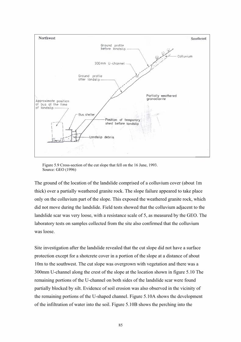
Figure 5.9 Cross-section of the cut slope that fell on the 16 June, 1993. Source: GEO (1996)
The ground of the location of the landslide comprised of a colluvium cover (about 1m
thick) over a partially weathered granite rock. The slope failure appeared to take place
only on the colluvium part of the slope. This exposed the weathered granite rock, which
did not move during the landslide. Field tests showed that the colluvium adjacent to the
landslide scar was very loose, with a resistance scale of 5, as measured by the GEO. The
laboratory tests on samples collected from the site also confirmed that the colluvium
was loose.
Site investigation after the landslide revealed that the cut slope did not have a surface
protection except for a shotcrete cover in a portion of the slope at a distance of about
10m to the southwest. The cut slope was overgrown with vegetation and there was a
300mm U-channel along the crest of the slope at the location shown in figure 5.10 The
remaining portions of the U-channel on both sides of the landslide scar were found
partially blocked by silt. Evidence of soil erosion was also observed in the vicinity of
the remaining portions of the U-shaped channel. Figure 5.10A shows the development
of the infiltration of water into the soil. Figure 5.10B shows the perching into the
85

colluvium and the overflowing of the channel, which ultimately resulted in the
landslide.
A
B
Figure 5.10A&B The conditions of failure of the slope on 16 June, 1993 Source: GEO (1996)
86
5.3.3.5 Probable Causes of the Landslide Many factors contributed to the landslide at Cheung Shan Estate on 16 June 1993.
However, the main reasons were the formation of the soil structures of the slope and the
intense rainfall. The colluvium at the crest of the cut slope was very loose although it
might have been slightly reinforced by plant roots in the ground. The cut slope was
stable when it was dry. However, the rainfall in early June would probably have
saturated the colluvium in the slope. Upon saturation, the colluvium cover became
unstable.
During the heavy rainfall on 16 June, rainwater could infiltrate the ground, which was
covered by natural vegetation. Water that entered the ground would tend to flow
vertically downwards under the force of gravity. When the water met the less permeable
granite rock, its direction of movement became parallel to the surface of the granite
rock, forming an infiltration of water between these two soil types. The pressure
generated by this infiltration of water made the slope unstable. As the infiltration
continued, the water pushed the 1 m layer of colluvium up, the friction was lost and the
gravity pulled the mass of colluvium down the slope. Due to poor maintenance of the
300mm U-channel, the surface water from the upper part of the natural slope could not
be drained effectively. Water therefore overflowed onto the cut slope during heavy
rainfall, which increased the amount of water infiltrating into the cut slope. This
contributed to the slope failure.
This case study shows the serious damages that landslides could cause in Hong Kong.
As the urban area is densely populated, artificial cuttings on slopes have been
constructed to stabilise the slopes after land has been cleared for buildings, roads and
other constructions (Alt, 1997). In addition to the man-made alterations in the landscape
of Hong Kong, the conventional reasons of soil structures and high rainfall remain. In
this particular case, the water’s role on soil structures was devastating. As these
characteristics are common in Hong Kong, combined with the dense population and
infrastructure, serious damages can be caused even in less dense areas, as was seen in
the example. As the example illustrated, poor maintenance led to the overflowing of the
drains, and caused the landslide. With a rapid urban expansion and man-made
87
alterations on the landscape of Hong Kong, absolute safety to the public is difficult to
maintain.
88
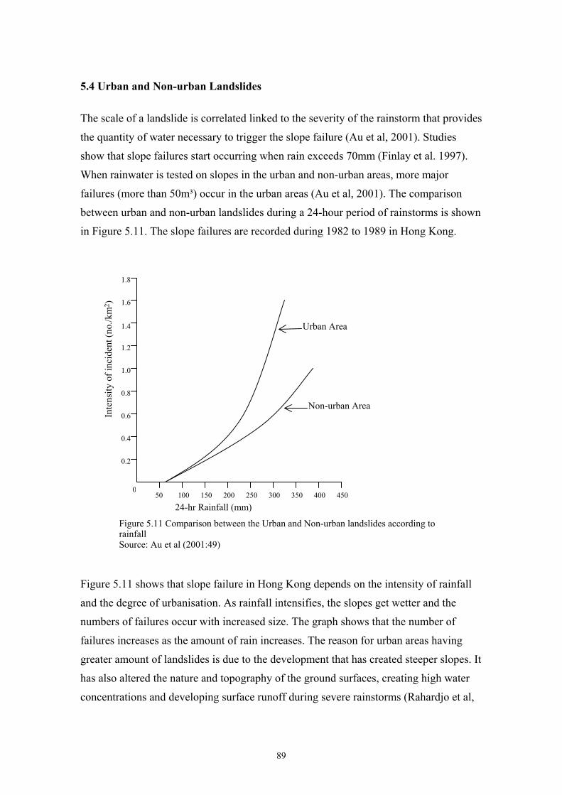
5.4 Urban and Non-urban Landslides
The scale of a landslide is correlated linked to the severity of the rainstorm that provides
the quantity of water necessary to trigger the slope failure (Au et al, 2001). Studies
show that slope failures start occurring when rain exceeds 70mm (Finlay et al. 1997).
When rainwater is tested on slopes in the urban and non-urban areas, more major
failures (more than 50m³) occur in the urban areas (Au et al, 2001). The comparison
between urban and non-urban landslides during a 24-hour period of rainstorms is shown
in Figure 5.11. The slope failures are recorded during 1982 to 1989 in Hong Kong.
1.8
1.6
Inte
nsity
of i
ncid
ent (
no./k
m2 )
Urban Area 1.4
Figure 5.11 shows that slope failure in Hong Kong depends on the intensity of rainfall
and the degree of urbanisation. As rainfall intensifies, the slopes get wetter and the
numbers of failures occur with increased size. The graph shows that the number of
failures increases as the amount of rain increases. The reason for urban areas having
greater amount of landslides is due to the development that has created steeper slopes. It
has also altered the nature and topography of the ground surfaces, creating high water
concentrations and developing surface runoff during severe rainstorms (Rahardjo et al,
050 100 150 200 250 300 350 400 450
0.2
0.4
0.6
0.8
1.0
1.2
Non-urban Area
24-hr Rainfall (mm)
Figure 5.11 Comparison between the Urban and Non-urban landslides according to rainfall Source: Au et al (2001:49)
89
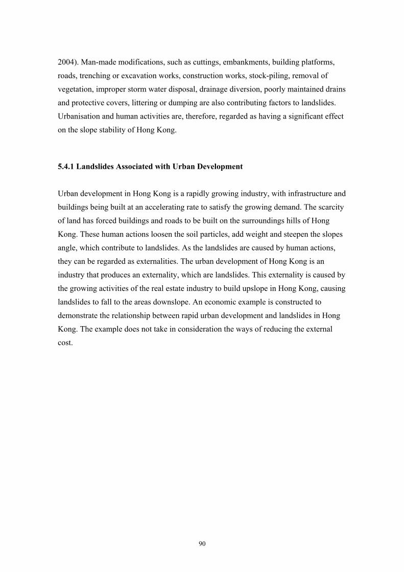
2004). Man-made modifications, such as cuttings, embankments, building platforms,
roads, trenching or excavation works, construction works, stock-piling, removal of
vegetation, improper storm water disposal, drainage diversion, poorly maintained drains
and protective covers, littering or dumping are also contributing factors to landslides.
Urbanisation and human activities are, therefore, regarded as having a significant effect
on the slope stability of Hong Kong.
5.4.1 Landslides Associated with Urban Development
Urban development in Hong Kong is a rapidly growing industry, with infrastructure and
buildings being built at an accelerating rate to satisfy the growing demand. The scarcity
of land has forced buildings and roads to be built on the surroundings hills of Hong
Kong. These human actions loosen the soil particles, add weight and steepen the slopes
angle, which contribute to landslides. As the landslides are caused by human actions,
they can be regarded as externalities. The urban development of Hong Kong is an
industry that produces an externality, which are landslides. This externality is caused by
the growing activities of the real estate industry to build upslope in Hong Kong, causing
landslides to fall to the areas downslope. An economic example is constructed to
demonstrate the relationship between rapid urban development and landslides in Hong
Kong. The example does not take in consideration the ways of reducing the external
cost.
90
S
R
U
T
MSC = MPC + MEC
In figure 5.12, curve D represents the market demand for housing upslope. It also
represents the benefits to the society, MSB. The supply of housing units upslope by the
real estate industry is represented with the curve S. This supply curve also represents the
marginal private costs (MPC) of all the inputs of the housing industry. These would
include land, labour, capital and materials, et cetera. However, landslides are caused in
the process of building upslope, this damage cost is represented by the marginal
external cost (MEC) curve. This cost represents the monetary value of landslide damage
imposed on the society by the real estate industry, or the growth of the urban
development. The MEC does not start to materialise until the building activities reach a
production level of Qm. This is because the building activities upslope could reach a
certain level before the externality emerges. The MEC curve is expected to be positively
sloped, as the growth of the upslope buildings is positively related to the occurrences of
landslides.
Through free market mechanism, the level of production of the buildings upslope would
be at point U, where MPB = MPC. It is the point where the production satisfies the
S = MPC
Ps
Pric
e ($
)
Pe
MEC
D = MSB
0 Qs QeQm
Housing Units
Figure 5.12 External cost of Rapid Urban DevelopmentSource: Hussen (2000:101)
91
social demand for housing while covering the industry’s production costs. However, it
fails to take into consideration the external cost, which is TU. This external cost would
have to be borne by the whole society when landslides occur. On the other hand, the
socially optimal level of production is at point S, which is the equilibrium of MSC and
MSB, where the highest level of social benefit is gained. At this point, the external cost
of SR has incurred. However, the social benefits gained are large enough to compensate
this cost. If the production of housing upslope is to be reduced beyond Qs in order to
accommodate the external costs, it would reduce the social benefits altogether. The
reduction of housing upslope could reduce the level of externality, however, it would
also reduce the benefits to the society in a greater extent. Therefore, the limitation on
building upslope is not the most viable option in a city like Hong Kong where
population keeps increasing. It is more realistic for the city to invest in ways of reducing
the externality through various landslide management methods and government
intervention.
Due to the instability of slopes, the mechanisms of the slope failures have been the
subject of extensive research in government agencies and local universities since the
1970’s. The previous studies have led to many archived reports and lots of insights and
experiences on slope movements, failure mitigation, and remedial work design (Jiao,
2000). There are multiple experiments carried out on the soils and water of Hong Kong
to determine their relationship to landslides. The Geotechnical Engineering Office
(GEO) has carried out the main research on soils and their relationship to landslides in
Hong Kong. Research on shear strength of soils, pore water pressure on various soils,
soil suction, instability of soils and weathering of soils, et cetera, have been carried out
to find out ways to reduce landslides. Landslide prevention methods in Hong Kong have
become very important in order to protect the valuable urban area of Hong Kong and its
6.9 million people. The research and programmes of GEO will be discussed in the Hong
Kong Government intervention on landslides next.
92
5.5 Management of Landslides
The general landslide mitigation techniques were reviewed in chapter three. The slope
management techniques of Hong Kong will be reviewed here with discussing on their
respective characteristics, costs and advantages. Since heavy rainfall and surface runoffs
are contributing to slope failure, in Hong Kong. Surface draining systems and protective
cover are used to shield slopes from water entering the soils. Systematic surface drains
on the slopes of Hong Kong control the direction of water flow, making it difficult to
erode and infiltrate the soils. This is an important aspect to remember when looking at
the man-made slopes of Hong Kong.
5.5.1 Man-made Slopes
Man-made slopes are the main type of slope stabilisation method in Hong Kong. The
government regulation states that the man-made slopes of Hong Kong should be formed
to their maximum allowable angle and height. Angles of soil cut and fill slopes are in
the range of 50° to 60° and 30° to 40° to the horizontal respectively (Au et al, 2001).
The man-made slopes have an open concrete lined half-round or U-shaped channels
constructed at the crest and the toe of the slope. These drains intercept and direct the
water away from running on the slopes. Steps are built on the channels to reduce the
velocity of flow where the gradient is steep. Catchpits are placed to trap the possible
splashing where drains join or when drains change direction at steep angles. Sand traps
are constructed at the toe of the slope to collect silt and trash. All of these drainage
systems, if properly maintained, are designed to discharge rainwater and surface water
safely and effectively from the slopes.
The slope body is usually protected from infiltration and erosive effects of water by
impermeable hard cover. Chunam plaster, a mixture of soil, lime and cement, and
shotcrete are the most frequently used for hard covers of slopes in Hong Kong. The
chunam cover is placed in two different layers, each about 25mm thick with
construction joints to provide extra strength. Shotcrete is usually 50 to 70mm thick.
Weepholes are provided to prevent water pressure from building up inside the slope,
which would crack the slope cover.
93
The characteristics of drains, channels and a hardcover of either chunam or shotcrete are
standard for man-made slopes. However, in Hong Kong, the greening or aesthetic side
to slope maintenance has become a highly important feature in the industry. The intense
urban landscaping of Hong Kong and the importance of beauty to the public has created
the greening industry. The important greening industry provides various different
natural covers to please the aesthetic side of slopes. Besides its aesthetic characteristics,
the various natural covers also help in the absorption of water by rooting systems,
provide protective cover and strength to the slopes. The research will examine the
various greening techniques used on the Hong Kong slopes. Their characteristics to
aesthetic qualities, functionality and costs of installation will be examined.
5.5.2 The ‘Greening Techniques’
The greening techniques in Hong Kong provide a natural characteristic to the man-made
slopes. There are three main types of greening techniques that are used in Hong Kong.
They are the mulching system, planting of long-rooting grass and fibre reinforced soil
system. Each of these techniques has their unique characteristics, which can be applied
to suit various slope structures and cost requirements. There are also variations in
application techniques, costs of installation, appearances and functionality. Each of
these methods will be examined and compared according to their costs and benefits.
94

5.5.2.1 Mulching System
The Mulching System is to provide a protective cover on man-made slopes making it
possible for natural vegetation to grow on the non-soil slope surface. The hard cover of
the man-made slope is initially covered by a turf reinforcement mat. A layer of wire
meshes with fertiliser strips is then installed to provide additional nutrients and moisture
to the vegetation. A soil cover is then sprayed on and vegetation seeds are planted. It is
then covered by a biodegradable erosion control mat and held by anchor pin to the hard
cover. A natural vegetative cover is therefore, allowed to grow through the mat,
securing it in place so as to prevent it from failing. This system provides a vegetation
cover in which its extensive rooting system adds strength to the soils. The cover also
absorbs excessive rainwater, which is the primary cause of landslides in Hong Kong
(ToyoGreen, 2003a). Figure 5.13 shows the layers of the Mulching method.
Anchor pins
Voids and holes (uneven surface)
Turf enforcement mat and layers of wire mesh
Vegetation
Biodegradable erosion control mat
Layer of soilHard cover
Figure 5.13 Mulching method Source: Mak (2004)
95

5.5.2.2 Planting of Long-Rooting Grass
This system is a fast and cost-effective system to cover man-made slopes. The strong
and dense vertical root system holds the soil particles together underneath the hard
cover. This deep-rooted grass system has high tolerance to drought, strong wind and
poor soil quality. This system is applied by drilling planter holes onto the hard cover.
The planter holes are drilled with diameter of 200mm and a depth of 200mm at
1,000mm vertical and 800mm horizontal stagger pattern. A plastic tube is placed around
the hard cover to prevent it from cracking. The drilled hole is then filled with soil mix
and fertilisers, and finally, the long-rooting grass is planted within. This is a low
maintenance technique, which provides an even vegetative coverage to the slope
(ToyoGreen, 2003b). Figure 5.14 shows the long rooting-grass system.
Chunam or shotcrete cover
Long rooting grass
Rock
Planter hole
Soil
Figure 5.14 Long rooting grass system Source: Mak (2004)
96
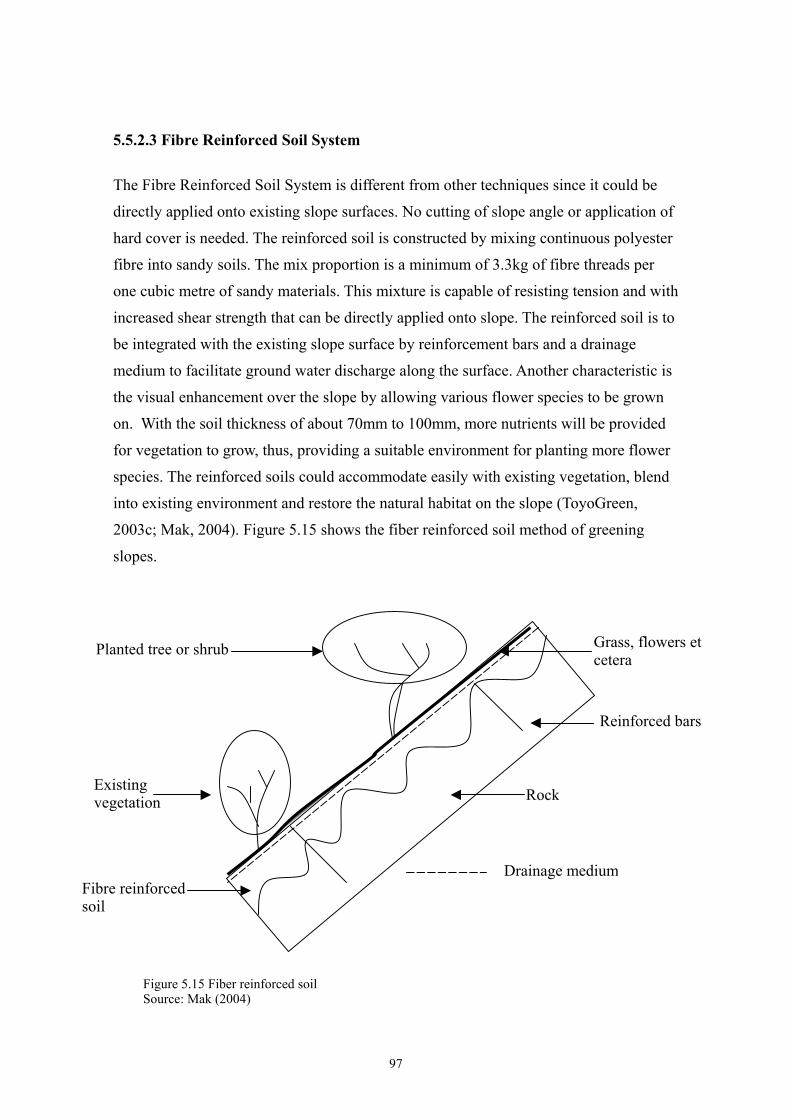
5.5.2.3 Fibre Reinforced Soil System
The Fibre Reinforced Soil System is different from other techniques since it could be
directly applied onto existing slope surfaces. No cutting of slope angle or application of
hard cover is needed. The reinforced soil is constructed by mixing continuous polyester
fibre into sandy soils. The mix proportion is a minimum of 3.3kg of fibre threads per
one cubic metre of sandy materials. This mixture is capable of resisting tension and with
increased shear strength that can be directly applied onto slope. The reinforced soil is to
be integrated with the existing slope surface by reinforcement bars and a drainage
medium to facilitate ground water discharge along the surface. Another characteristic is
the visual enhancement over the slope by allowing various flower species to be grown
on. With the soil thickness of about 70mm to 100mm, more nutrients will be provided
for vegetation to grow, thus, providing a suitable environment for planting more flower
species. The reinforced soils could accommodate easily with existing vegetation, blend
into existing environment and restore the natural habitat on the slope (ToyoGreen,
2003c; Mak, 2004). Figure 5.15 shows the fiber reinforced soil method of greening
slopes.
Rock
Planted tree or shrub Grass, flowers et cetera
Existing vegetation
Fibre reinforced soil
Drainage medium
Reinforced bars
Figure 5.15 Fiber reinforced soil Source: Mak (2004)
97
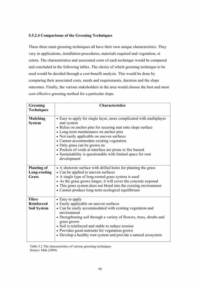
5.5.2.4 Comparisons of the Greening Techniques
These three main greening techniques all have their own unique characteristics. They
vary in applications, installation procedures, materials required and vegetation, et
cetera. The characteristics and associated costs of each technique would be compared
and concluded in the following tables. The choice of which greening technique to be
used would be decided through a cost-benefit analysis. This would be done by
comparing their associated costs, needs and requirements, duration and the slope
outcomes. Finally, the various stakeholders in the area would choose the best and most
cost-effective greening method for a particular slope.
Greening Techniques
Characteristics
Mulching System
• Easy to apply for single layer, more complicated with multiplayer mat system
• Relies on anchor pins for securing mat onto slope surface • Long-term maintenance on anchor pins • Not easily applicable on uneven surfaces • Cannot accommodate existing vegetation • Only grass can be grown on • Pockets of voids at interface are prone to fire hazard • Sustainability is questionable with limited space for root
development
Planting of Long-rooting Grass
• A shotcrete surface with drilled holes for planting the grass • Can be applied to uneven surfaces • A single type of long-rooted grass system is used • As the grass grows longer, it will cover the concrete exposed • This grass system does not blend into the existing environment • Cannot produce long-term ecological equilibrium
Fibre Reinforced Soil System
• Easy to apply • Easily applicable on uneven surfaces • Can be easily accommodated with existing vegetation and
environment • Strengthening soil through a variety of flowers, trees, shrubs and
grass grown • Soil is reinforced and stable to reduce erosion • Provides good nutrients for vegetation grown • Develop a healthy root system and provide a natural ecosystem
Table 5.2 The characteristics of various greening techniquesSource: Mak (2004)
98
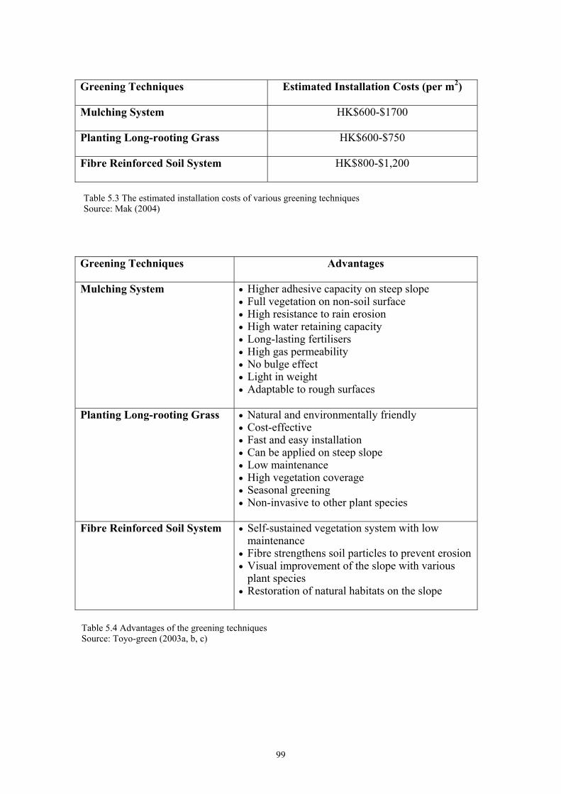
2Greening Techniques Estimated Installation Costs (per m ) Mulching System HK$600-$1700 Planting Long-rooting Grass HK$600-$750 Fibre Reinforced Soil System HK$800-$1,200
Greening Techniques Advantages
Mulching System
• Higher adhesive capacity on steep slope • Full vegetation on non-soil surface • High resistance to rain erosion • High water retaining capacity • Long-lasting fertilisers • High gas permeability • No bulge effect • Light in weight • Adaptable to rough surfaces
Planting Long-rooting Grass
• Natural and environmentally friendly • Cost-effective • Fast and easy installation • Can be applied on steep slope • Low maintenance • High vegetation coverage • Seasonal greening • Non-invasive to other plant species
Fibre Reinforced Soil System
• Self-sustained vegetation system with low maintenance
• Fibre strengthens soil particles to prevent erosion • Visual improvement of the slope with various
plant species • Restoration of natural habitats on the slope
Table 5.3 The estimated installation costs of various greening techniquesSource: Mak (2004)
Table 5.4 Advantages of the greening techniquesSource: Toyo-green (2003a, b, c)
99
5.5.3 Maintenance of Slopes
The maintenance of slopes is extremely important in regard to its effectiveness on
successful drainage of water. Surface drains are very vulnerable to blockage. Materials
that are brought down by runoff water, such as soils and leaves, twigs, rubbish et cetera,
are usually left in the drains. When the drains are blocked, the water in the channels
cannot flow naturally away from the slopes. Usually, a spill over would occur and the
water will be forced out of the drain onto the slope. As the water is not controlled, it can
flow onto the vulnerable areas of the slope, infiltrate into the soils, causing a slope
failure. Channels that are situated at the top of the slopes are the most vulnerable to
slope failure. A slope lacking proper drain maintenance is more likely to collapse than a
slope without drains (ERM, 1998). Hong Kong’s tropical climate is inviting to fast
growing natural vegetation. Vegetation can take rooting easily to soil debris or
decomposed vegetation. This can lead to drains and channels quickly being overgrown
with vegetation, ultimately blocking the drain. Maintenance such as, clearing the drains
and catchpits, repairing the cracked and damaged drains, chunam and shotcrete covers,
removing unplanted vegetation and surface debris is essential to continue slope stability.
However, often in Hong Kong, due to the confusion of the responsibility of
maintenance and the lack of awareness, these simple tasks are rarely carried out. Many
private slopes are simply left unattended for decades after their construction, with no
inspection or maintenance being carried out until failure occurs.
100
5.6 Hong Kong Government Intervention on Landslide Issues
The Hong Kong government has a huge responsibility to its public to maintain its vast
public land from landslides. As landslides are a threat to society, the government has the
responsibility to protect their citizens, especially those on public land. Special
departments have been created to ensure that safety from landslides is maintained.
Leung (2004) states that, “it is the Government’s objective and vision on landslide risk
management to meet Hong Kong’s needs for the highest standards of slope safety”. To
achieve this objective and vision, a comprehensive Slope Safety System has been
formulated under the policy direction of the Works Bureau. The Slope Safety System is
managed by the GEO of the Civil Engineering Development Department (CEDD). The
GEO currently has a professional staff establishment of over 200 specialist engineers
and scientists, who are supported by approximately 350 technical grade staff in
geotechnical, civil, explosives, quarrying, laboratory, cartographic and works
supervisory streams. In total, the GEO has a staff establishment of over 700 for its wide
range of activities (Leung, 2004).
The department’s overall target is to achieve further reduction in risks to the whole
community as quickly as possible. The Government’s plan to meet these goals is
through seven key principles. They are as follows:
5.6.1 Improve Slope Safety Standards
The GEO maintains its slope safety through investigating and researching the causes of
significant and serious landslides to improve the Slope Safety Systems. Especially,
geotechnical research, including the study of natural terrain instability is important in
regards to landslides. By conducting research and gathering knowledge from past
examples, the reasons of slope failure can be found out (Wong & Ho, 1997). This helps
to improve the slope protection and stabilisation measures to be more effective in the
future. This is a method of risk assessment and hazard mapping as described in details
in chapter two.
101
As the natures of slopes of Hong Kong are determined, slope protection and
stabilisation methods can be installed. With the installation of building and
infrastructure developments, such as man-made slopes with controlled drainage, will
decrease the number of landslides. This method can be referred to the government
intervention of ‘direct production of environmental quality’, as it is a physical method
of improving safety and the environment.
Another effective method of improving safety from landslides is by publishing
legislative slope safety standards and professional guidance. This is also an important
way to raise awareness and set a standard of slope maintenance. It is a form of a ‘moral
suasion’ as well as setting regulations, therefore a ‘Command and Control’ government
intervention method.
5.6.2 Ensure Safety Standards of New Slopes
The Hong Kong Government is continuously examining the design and supervision of
construction of new slopes. By doing so the high standard of slope protection and
stabilization methods are maintained. In addition, the GEO provides inputs to land use
planning, which is essential in decreasing the possible damages that the landslide might
cause. With good land use planning, landslide prone areas can be avoided. In addition,
the possible man-made alterations to the landscape, such as road cuttings, construction
of heavy buildings on upslope et cetera, will be minimized.
5.6.3 Rectify Substandard Government Slopes
The Government has implemented the Landslide Preventative Measures program
(LPM) to upgrade high priority large substandard Government slopes. The LPM
Program has an annual expenditure of about HK$870 million to upgrade substandard
Government slopes and undertake safety-screening of old private slopes (CEDD, 2004).
102
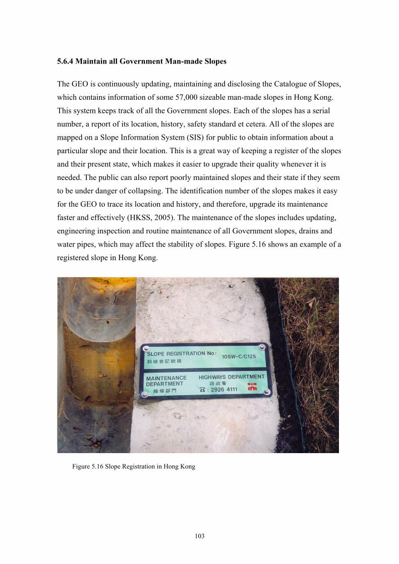
5.6.4 Maintain all Government Man-made Slopes
The GEO is continuously updating, maintaining and disclosing the Catalogue of Slopes,
which contains information of some 57,000 sizeable man-made slopes in Hong Kong.
This system keeps track of all the Government slopes. Each of the slopes has a serial
number, a report of its location, history, safety standard et cetera. All of the slopes are
mapped on a Slope Information System (SIS) for public to obtain information about a
particular slope and their location. This is a great way of keeping a register of the slopes
and their present state, which makes it easier to upgrade their quality whenever it is
needed. The public can also report poorly maintained slopes and their state if they seem
to be under danger of collapsing. The identification number of the slopes makes it easy
for the GEO to trace its location and history, and therefore, upgrade its maintenance
faster and effectively (HKSS, 2005). The maintenance of the slopes includes updating,
engineering inspection and routine maintenance of all Government slopes, drains and
water pipes, which may affect the stability of slopes. Figure 5.16 shows an example of a
registered slope in Hong Kong.
Figure 5.16 Slope Registration in Hong Kong
103
5.6.5 Ensure that Owners Take Responsibility for Slope Safety
One of the Hong Kong’s government interventions is to see that the private owners of
slopes take responsibility for slope safety. This ‘Command and Control’ method sets
regulations on slopes for publics safety. For example, safety screening of old private
slopes, enforcing owners to investigate and carry out necessary upgrading works to
slopes. Private owners are required by law to carry out the necessary slope repair works.
According to the Buildings Ordinance, slope owners have the responsibility to carry out
the required maintenance works, if the slopes are found to be dangerous (HKSS, 2005).
If a slope owner does not comply with the regulation, prosecution will lead to a HK
$50,000 fine, and to imprisonment to 1 year (Chan, 1996).
5.6.6 Promote Public Awareness
One of the important government interventions regarding slope safety in Hong Kong is
spreading public awareness, education and information about landslides. The education
includes descriptions of landslides, their dangers and what should be done when a
landslide is predicted to happen. Public exhibitions are also held by the CEDD, to
educate the public about Hong Kong’s geology as well as teaching ways of avoiding
damages in case of a landslide, and how to reduce them through appropriate actions
(Chan, 1998).
Information and community advisory services have also been set up by the Government
to help the public in issues concerning landslides. This service provides assistance and
advice to people that want to know for example how to deal with a possible landslide or
legislation about whom is responsible for a certain slope.
Warning and emergency services have also been installed for improved public safety.
The operation of a 24-hour year-round emergency service by geotechnical engineers to
protect public safety ensures that emergency help is dispatched as fast as possible to
lessen the damages and casualties from landslides. A technical example of this is the
extensive network of automatically recording rain gauges throughout Hong Kong that
provide real time rainfall data for the issue of public Landslip Warnings. The landslip
104

warning is issued if substantial amount of rain falls in landslide prone areas. The
Landslip Warning would generally be issued if the 24-hour rainfall was expected to
exceed 175mm, or the 60-minute rainfall was expected to exceed 70mm, over a
substantial part of the urban area (HKSS, 2005).
5.6.7 Enhance the Appearance and Aesthetics of Engineered Slopes
One of the Hong Kong Government’s objectives is to make the slopes look as natural as
possible and to blend them with the surroundings. Technical guidelines have been
issued on good practices in landscape treatments and bioengineering for slope works.
All newly constructed and upgraded Government slopes are landscaped, and the use of
hard surfacing in slope works is minimised. The GEO is also continuously looking to
improve the technology in greening slopes while using the common methods of
mulching and seeding of slopes. These methods are applied to improve the aesthetic
aspects of all newly formed and upgraded Government slopes. The GEO also
encourages private slope owners to improve the appearance of their slopes. The GEO
offers a cheap service of aesthetic maintenance, which is an incentive for the private
slope owner to comply.
105
5.7 Current Situation
Since the establishment of the GEO in 1977, the Government of Hong Kong has
achieved a lot in enhancing slope safety. The Slope Safety System and its geotechnical
standards are well respected internationally and set a great example of how to improve
slope safety from landslides. With a total expenditure of about HK$600 million each
year by the various departments to maintain all Government slopes, the safety of the
Hong Kong public from the dangers of landslides has been improved drastically.
According to the risk assessment calculations, the overall landslide risk arising from old
substandard man-made slopes to the whole community of Hong Kong has been reduced
to about 50% of the risks that existed in 1977 (CSB, 2005).
The effectiveness of the Slope Safety System is also indicated by the declining casualty
rate. The overall risk level from landslides has been minimised, which should not raise
concerns about serious dangers in Hong Kong. However, the Hong Kong Government
feels that there is always room for improvement. “We regard even one casualty from
landslide as unacceptable. We will continue to strive to further reduce risk to the whole
community as quickly and effectively as can be practically achieved. Because of Hong
Kong's physical setting and history of development, the risk can never be zero, and our
slope safety problems cannot be solved by Government actions alone” (CEDD, 2004).
The high standard of slope safety can be maintained if the Government and their
interventions continue to work in partnership with the whole community. This can be
achieved through government interventions on their public slopes as well as offering
incentives to private slope owners to encourage them to take necessary precautionary
measures to protect themselves and their families from landslide risks. The Government
will also continue to provide assistance through public education, public information
services and community advisory services. With these guidelines, the dangers of
landslides can be minimised effectively. The GEO’s objective is to further reduce the
landslide risk from old man-made slopes to below 25% of the 1977 level by the year
2010 (Leung, 2004).
106
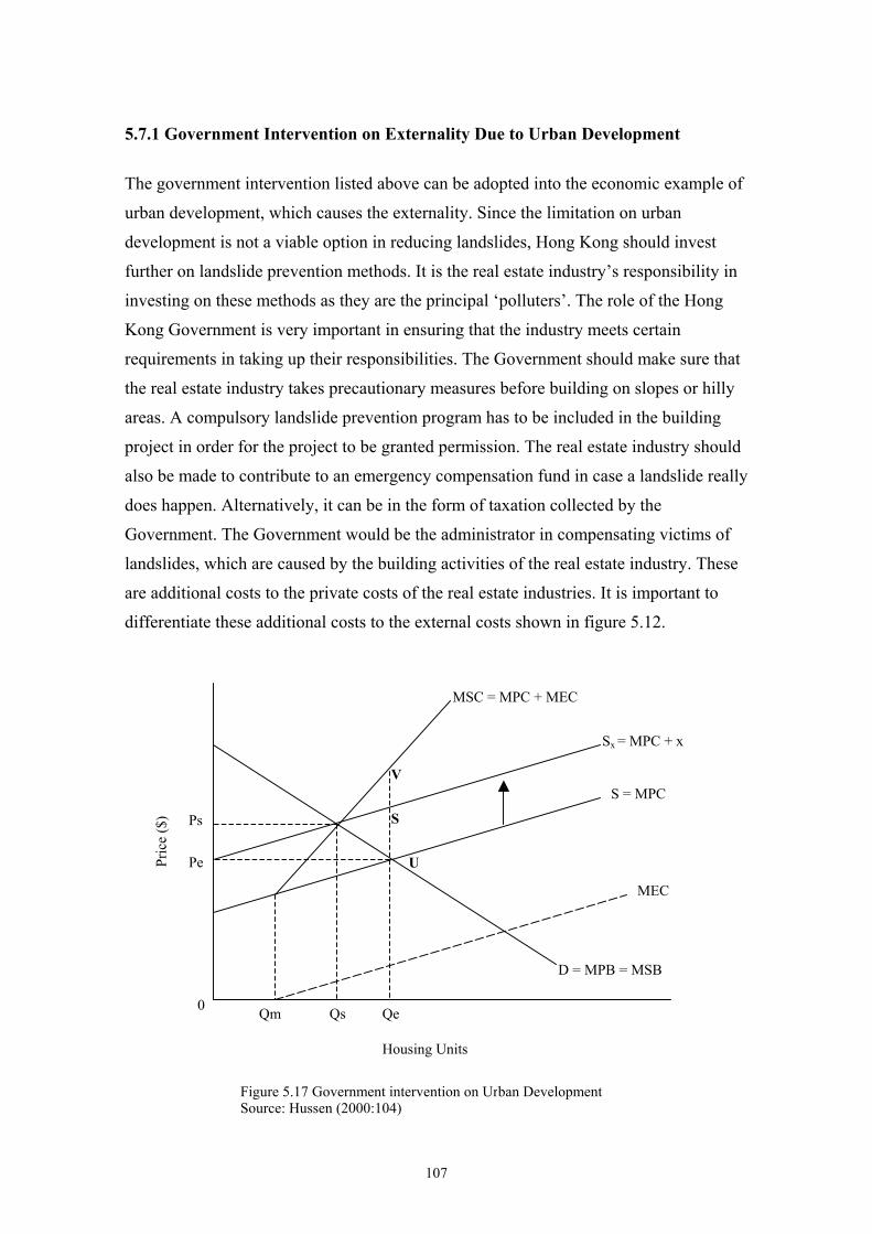
5.7.1 Government Intervention on Externality Due to Urban Development
The government intervention listed above can be adopted into the economic example of
urban development, which causes the externality. Since the limitation on urban
development is not a viable option in reducing landslides, Hong Kong should invest
further on landslide prevention methods. It is the real estate industry’s responsibility in
investing on these methods as they are the principal ‘polluters’. The role of the Hong
Kong Government is very important in ensuring that the industry meets certain
requirements in taking up their responsibilities. The Government should make sure that
the real estate industry takes precautionary measures before building on slopes or hilly
areas. A compulsory landslide prevention program has to be included in the building
project in order for the project to be granted permission. The real estate industry should
also be made to contribute to an emergency compensation fund in case a landslide really
does happen. Alternatively, it can be in the form of taxation collected by the
Government. The Government would be the administrator in compensating victims of
landslides, which are caused by the building activities of the real estate industry. These
are additional costs to the private costs of the real estate industries. It is important to
differentiate these additional costs to the external costs shown in figure 5.12.
MSC = MPC + MEC
Ps
Pe
0 Qm Qs Qe
S = MPC
MEC
D = MPB = MSB
Housing Units
Pric
e ($
)
Sx = MPC + x
V
S
U
Figure 5.17 Government intervention on Urban DevelopmentSource: Hussen (2000:104)
107
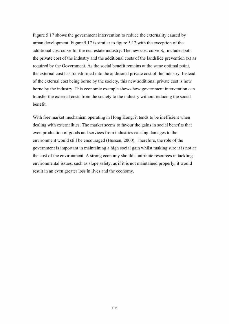
Figure 5.17 shows the government intervention to reduce the externality caused by
urban development. Figure 5.17 is similar to figure 5.12 with the exception of the
additional cost curve for the real estate industry. The new cost curve Sx, includes both
the private cost of the industry and the additional costs of the landslide prevention (x) as
required by the Government. As the social benefit remains at the same optimal point,
the external cost has transformed into the additional private cost of the industry. Instead
of the external cost being borne by the society, this new additional private cost is now
borne by the industry. This economic example shows how government intervention can
transfer the external costs from the society to the industry without reducing the social
benefit.
With free market mechanism operating in Hong Kong, it tends to be inefficient when
dealing with externalities. The market seems to favour the gains in social benefits that
even production of goods and services from industries causing damages to the
environment would still be encouraged (Hussen, 2000). Therefore, the role of the
government is important in maintaining a high social gain whilst making sure it is not at
the cost of the environment. A strong economy should contribute resources in tackling
environmental issues, such as slope safety, as if it is not maintained properly, it would
result in an even greater loss in lives and the economy.
108
Conclusion
Landslides are a form of mass movements, which can be described as the downslope
movement of soil, sediment and rock (Abbott, 2002). This downward movement of land
is mainly driven by the pull of gravity. Other natural characteristics also contribute to
landslides. These are soil structure, rainfall and the interaction between the two. Man-
made alteration due to rapid urban development is also a contributory factor. Slope
cuttings destroy the natural compaction and strength of the soil; infrastructure add
weight to the slope; and deforestation erases the natural vegetative cover that protects
the slope surface and internally the root system that holds soil particles together
(Bennett & Doyle, 1997; McGeary et al. 2001; ToyoGreen, 2003d).
Landslides are associated with the concept of risk (Coburn et al., 1994). As landslides
can cause serious damages to infrastructure and lives, the public feel unsafe from these
dangers. Risk can be separated into risk assessment, risk valuation, and risk
management (Field & Field, 2002). Risk assessment is carried out by gathering
information through surveillance, forecasting and prediction into a document called a
hazard map. With the use of a hazard map, the probabilities of the occurrence of a
landslide and the magnitude of the possible slide can be calculated. This helps in the
process of planning on how a possible landslide should be dealt with, for example, to
assess whether the benefits of a prevention method outweigh its costs. Risk valuation
places an order of importance of the people and infrastructure at risk. Firstly, it is
essential to ensure the safety of the most vulnerable and important people and
infrastructure of a community. Secondly, it is important to protect the necessities that a
society needs in a case of an emergency (Coburn et al, 1994). Risk management are the
methods that reduce landslides through preventing and protecting. It is also the means to
avoid them and knowing what to do when the danger occurs.
There are several landslide stabilisation and protecting methods that reduce landslides
and their damages. The stabilisation methods include, (1) by simply cutting the slope
angle to reduce the gravitational pull of the mass; (2) by placing a retaining wall at the
cutting of the slope to stop downward movement of mass; (3) by building an artificial
slope with drainage and ‘greening techniques’ (Bennett & Doyle, 1997).
109
Protection methods are usually used when landslides are impossible to prevent. These
methods lessen the actual damages of the falling mass on the infrastructure and people.
The methods commonly used for landslide protection include: catch fences, catch
ditches, netting strategies, and rock bolts and anchors (Chatwin, 1994). Hard covers
such as shotcrete and chunam are also used. Landslide stabilisation and protection
methods are not always one single method but a combination of several different
methods. Using a combination of different methods make the techniques more resilient
to different forms of stress under certain circumstances and uncertainty. This also makes
them stronger and safer. Proper maintenance after the method being installed has a very
crucial role in sustaining the quality of the slope (Schwab, 1994).
When landslides are treated as an environmental problem, several environmental
economic theories can be applied. The foremost concept associated is cost. Every
decision is made with consideration of the cost incurred behind a commodity or action
(Uribe et al, 1999). Costs of landslide are different depending on the nature of the
landslides. When landslides are regarded as natural hazard, the costs would refer to the
damages that caused to the society in general. However, when landslides are caused by
human actions, its costs would be regarded as an external cost that are additional to the
private costs of that activity (Kahn, 1995). Emphasis is placed on the situation when
landslides triggered by human actions, a polluter pays principle through legislation is
used to determine the parties who should be responsible for the costs. Compensation
between the ‘polluter’ and the ‘victim’ are usually determined through land rights
issues. Ronald Coase argues against this point in the Coase Theorem. The Coase
Theorem was used to show that in theory a mutually beneficial agreement would be
reached regardless of the property rights in regard to compensation from an externality,
landslide. Therefore, a social benefit will be reached when the parties negotiate an
agreement that will be a gain for both (Perman et al, 2003). Other environmental
economic theories such as cost-benefit analysis and ‘willingness to pay’ were also
reviewed to show that concepts designed mainly for conventional pollution could also
be adopted to the case of landslides. Landslides, their nature, the risks associated with,
reasons for failure, stabilisation methods and government’s role were then looked at
specifically in the Hong Kong example of landslides.
Landslides in Hong Kong are relatively frequent, with most slides being relatively small
110
in scale. However, there are less frequent large slides that cause damages to
infrastructure and kill or injure people (Au et al, 2001). The main reasons of slope
failure in Hong Kong are the structure of its soils, high rainfall due to tropical climate
and the rapid urban expansion. There are numerous physical methods that have been
adopted in reducing the risks associated with landslides. These methods are cutting of
slopes, construction of man-made slopes and drainage systems and ‘greening methods’.
The ‘greening methods’ are especially favourable in Hong Kong. They provide a natural
cover to the slopes through mulching system, planting long-rooting grass and by fibre
reinforced soil system (ToyoGreen, 2003d).
As the majority owner of land, the Government of Hong Kong has a huge role in
protecting its people from landslides. Besides physical prevention, the government
intervention into reducing landslides is done by researching the causes of landslides,
public education, spreading awareness, setting up emergency and information centres,
enforcing command and control methods on private landowners to take responsibility of
their slopes, and offering incentives for maintaining their slopes (CEDD, 2004). The
government intervention in Hong Kong has had successful results. The risk from
landslides has been reduced by 50 percent from 1977 (Leung, 2004). However, there is
always a danger from landslides in Hong Kong as the urban area is continuously
spreading. With the increasing population and demand for housing, the real estate
industry responds by building upslope. The risk from landslides, therefore, increases
and the damages from a potential slide become greater (Alt, 1997). The role of the Hong
Kong Government is of particular importance in ensuring that the industry is doing their
part to guarantee slope safety. Regulations and compensation mechanisms are to be
established and monitored by the Government.
The maintenance of slopes in the urban areas is also extremely important. It is more
likely for a slope to fail if it has an improperly maintained drainage system than a slope
without drainage. In addition, landslides in the urban areas are more frequent than in the
rural areas during heavy rainfall (Au et al, 2001). The risk was seen on the example
provided from 16 June 1993 in Kwai Chung. With the Hong Kong Government’s
expenditure on landslide prevention being HK$600 million, the landslides have been
greatly reduced. However, it is impossible to erase this natural and human induced
environmental problem in the surroundings of Hong Kong entirely.
111
Discussion
The research into landslides in Hong Kong was based on the interesting linkage
between a natural hazard, the concept of pollution and the ways that a society deals with
landslides and their associated risks.
Landslides are most commonly known as natural hazards. The research studied its
geological qualities, causes of failure and the risks that are associated with landslides.
The research then looked at landslides as pollution and adopted concepts of
environmental economics, mainly designed for conventional relations between humans
and the environment, such as air pollution. The research studied a natural hazard,
landslide, which is physical and its damages are visible in an instant, and treated it
through environmental economic theories as conventional pollution. In comparison, for
example, air pollution is a slow and quiet devastating environmental problem. Through
various lengths of time, it brings upon the problems of acid rain, greenhouse effect and
global warming. Although both of these environmental problems are partly caused by
human actions, landslides are not commonly viewed as an environmental problem. The
research demonstrated that the treatment of landslides is very close to the way that
conventional pollution is dealt with. For example, through the Coase Theorem, it was
possible to show how a landslide is transformed into an externality. By looking at the
landslide as an externality, it transformed into an environmental problem that someone
can be held responsible for. Therefore, a compensation framework could be set up and
the Coase Theorem applied.
Once the research established that landslides could be treated as pollution, the ways of
how to reduce them through policies and regulations were reviewed in the government
intervention section. Governments have great influence in environmental issues by
setting standards and restrictions on human behaviour. These can be done by physically
improving the environment, moral suasion, command and control methods, and
economic incentives. The research proved that the concepts used to tackle landslides are
actually similar to the ones used for conventional environmental protection.
When looking at Hong Kong, where landslides are frequent and the ways of reducing
them are advanced, similarities in the theories in government intervention on pollution
and methods of landslide prevention were found. Hong Kong is one of the most densely
112
populated cities in the world. Due to its geographical location, the city is surrounded by
mountainous hills. As the urban area is expanding, landslide prevention becomes
increasingly important to protect the vast urban area. If a landslide happened to occur
onto the urban area from the surrounding hills, the damages would be severe.
Fortunately, Hong Kong has a strong economy, which is able to support the numerous
methods of landslide management. Hong Kong has even specialised in the greening
methods of slopes to make them aesthetically natural looking and more amicable, which
is very important to the public of Hong Kong.
The ways that Hong Kong dealing with the risks associated with landslides is a great
example to other countries facing similar problems. However, landslides cause more
damages and lives in developing countries. This is not because of the greater landslide
frequency, but because of the greater vulnerability. Richer developed countries can
respond more efficiently, therefore minimise the damages even though the economic
loss may be much greater due to the greater level of structural investment. For example,
in the Philippines where the climate is similar to Hong Kong, landslides occur annually
with devastating effects. As a result of logging severe landslides killed more than 1100
people in the Philippines in December 2004 (SCMP, 2004d).
The research of landslides in Hong Kong provided a great experience into linking a
natural hazard and pollution into environmental economic theories. In addition,
studying Hong Kong as an example of how the threats from landslides can be dealt with
in reality. Finally, emphasising the importance of economy in the protection of our
environment. A strong economy is vital in the preservation of our environment from
‘pollution’, even in the case of landslides.
113
Reference List
Abbott, Patrick L. 2002. Natural Disasters. Boston: McGraw-Hill. Abdullah, A.M.L.B. & F.B.H. Ali. 1993. ‘Negative Pore Pressure Characteristics in
Partially Saturated Residual Soil’. Proceedings of the Eleventh Southeast Asian Geotechnical Conference Singapore. P.611-616.
AFP. 2004. ‘Deforestation Led to Haiti's Floods’. Agence France-Presse. May 29. Alt, Dave. 1997. ‘Expose Hong Kong’. Earth. 6[4]:34-35. Au, Stanley, K.S. Li & S-C. R. Lo (Eds). 2001. The Practice of Geotechnical
Engineering in Hong Kong. Hong Kong: Centre for Research and Professional Development.
Au, S.W.C. & R.Y.C. Suen. 1996. ‘Environmental Factors in Triggering Slope
Failures’. Proceedings of the Seventh International Symposium on Landslides, Trondheim. 2:611-616.
British Broadcasting Company (BBC). 2004. ‘Kenyan Ecologist Wins Nobel Prize’.
http://news.bbc.co.uk/2/hi/africa/3726024.stm. 8 Oct. Bennett, Matthew R. & Peter Doyle. 1997. Environmental Geology – Geology and
the Human Environment. Chichester: John Wiley & Sons Ltd. Barcia, R.B. 2004. ‘Albay Upland Farmers, Abandon “Kaingin” Ways’. The Manila
Times. Feb 26. http://www.manilatimes.net/national/2004/feb/26/yehey/prov/html.
Bulte, Erwin H. & Daniel P. Van Soest, 1996. ‘A Note on High Discount Rates and
Depletion of Tropical Forests’. Journal of Agricultural and Resource Economics. 21:341-350.
Central Intelligence Agency (CIA). 2005. Hong Kong http://www.cia.gov/cia/publications/factbook/geos/hk.html.
Chan, Ngai-Weng. 1998. ‘Responding to Landslide Hazards in Rapidly Developing
Malaysia: a Case of Economics Versus Environmental Protection’. Disaster Prevention and Management. 7[1]:14:32.
Chan, Y. C. 1996. GEO Report no. 52: Investigation of Some Major Slope Failures
Between 1992 and 1995. Hong Kong: Civil Engineering Department. Chatwin, S.C. 1994. ‘Measures for Control and Management of Unstable Terrain’.
Ministry of Forests, Canada. http://www.for.gov.bc.ca/hfd/pubs/docs/lmh/LMH18-06.pdf.
Chen, H. & C.F. Lee. 2000. ‘Numercial Simulation of Debris Flows’. Canadian
Geotechnical Journal. 37[1]:146-160.
114
Chleborad, Alan F. 1997. ‘Temperature, Snowmelt, and the Onset of Spring Season
Landslides in the Central Rocky Mountains’. U.S. Gelogical Survey. http://landslides.usgs.gov/html_files/nlic/OFR97-27/Ofr97-27.html.
Civil Engineering Development Department (CEDD). 2004. ‘Civil Engineering
Development Department’. http://www.cedd.gov.hk. Civil Service Bureau (CSB). 2005. ‘Using IT to Enhance Slope Safety’.
http://www.csb.gov.hk/hkgcsb/doclib/showcasing_ced_e.pdf. Coburn, A.W., R.J.S. Sspence & A. Pomonis. 1994. ‘Vulnerability and Risk
Assessment’. Disaster Management Training Programme. Dahanayake, Kapila. 2003. ‘Threat of Landslides in the Highlands - Importance of
Awareness Programmes’. Daily News. June 24. http://www.dailynews.lk/2003/06/24/fea01.html.
Dai, F.C. & C.F. Lee. 2001. ‘Terrain-based Mapping of Landslide Susceptibility
Using a Geographical Information System: A Case Study’. Canadian Geotechnical Journal. 38[5]:911-923.
Erickson, Jon. 2002. Environmental Geology: Facing the Challenges of Our
Changing Earth. New York: Facts on File, Inc. ERM. 1998. GEO Report no. 75: Landslides and Boulder Falls From Natural
Terrain: Interim Risk Guidelines. Hong Kong: Civil Engineering Department. Federal Emergency Management Agency (FEMA). 2004. ‘More Information on
Landslides’. http://www.fema.gov/hazards/landslides/whatis.shtm. Field, Barry C. & Martha K. Field. 2002. Environmental Economics: An
Introduction. New York: McGraw-hill/Irwin. Finlay P.J., R. Fell & P.K. Maguire. 1997. ‘The Relationship Between the Probability
of Landslide Occurrence and Rainfall’. Canadian Geotechnical Journal. 34[6]:811.
Halcrow. 2001. GEO Report no. 116: Review of Effective Methods of Integrating
Man-made Slopes and Retaining Walls (Particularly for Roadside Slopes) into Their Surroundings. Hong Kong: Civil Engineering Department.
Harris, Jonathan M. 2002. Environmental and Natural Resource Economics: A Contemporary Approach. Boston: Houghton Mifflin Company.
Hong Kong Observatory (HKO). 2005. ‘The Year’s Weather’.
http://www.weather.gov.hk/wxinfo/pastwx/ywx.htm. Hong Kong Slope Safety (HKSS). 2005. ‘Hong Kong Slope Safety’.
http://hkss.cedd.gov.hk/hkss/index.htm.
115

Hornby, A S. 2000. Oxford Advanced Learner’s Dictionary. Oxford: Oxford University Press.
Howes, D.E. & D.N. Swanston. 1994. ‘A Technique for Stability Hazard
Assessment’. Ministry of Forests, Canada. http://www.for.gov.bc.ca/hfd/pubs/docs/lmh/LMH18-02.pdf.
Hussen, Ahmed M. 2000. Principles of Environmental Economics: Economics,
Ecology and Public Policy. London: Routledge. Hydrometrics. 2003. ‘Lincoln County Montana Pre-disaster Mitigation Plan’.
http://www.lincolncountymt.us/EMA/03%20PreDisaster%20Mitigation%201st%20draft%2012-2-03.htm.
Jiao, Jiu Jimmy. 2000. ‘A Confined Groundwater Zone in Weathered Igneous Rocks
and its Impact on Slope Stability’. International Symposium on Hydrogeology and the Environment. http://hydro.geo.ua.edu/jiao/research/FullPaper/WH_Paper3.pdf.
Kahn, James R. 1995. The Economic Approach to Environmental and Natural
Resources. Orlando: The Dryden Press, Harcourt Brace College Publishers. Kaspersen, Janice. 2000. ‘Sculpted Soil Nail Walls Blend In on Highway 92’.
Erosion Control. http://www.forester.net/ec_0009_profile_walls.html. Kirk, P.A., S. D. G. Campbell, C. J. N. Fletcher & R. J. Merriman. 1997. ‘The
Significance of Primary Volcanic Fabrics and Clay Distribution in Landslides in Hong Kong’. Journal of the Geological Society. 154:1009.
Lam, C.Y. 2004. ‘The Weather Aspect of Disaster Planning and Preparedness in
Hong Kong’. Symposium on Planning and Preparedness for Weather-related Disasters, Hong Kong, China. 29-30 March.
Leung, S.F. 2004. ‘Slope Safety in Hong Kong’. Lumb, P. 1962. ‘General Nature of the Soils of Hong Kong’. Quarterly Journal of
Engineering Geology. 8:31-65. Mak, Norman S.C. 2004. ‘Geofibre Slopes in Hong Kong (Environmental Slope)’.
Transactions. 10[1]:1-5. McGeary, David, Charles C. Plummer & Diane H. Carlson. 2001. Physical Geology:
Earth Revealed. Boston: McGraw-Hill. Moy, Patsy. 2004. ‘Depths of History – Land Reclamation’. South China Morning
Post. Oct 16. pp.A14. Narayana, Dhruva. 2002. ‘Soil and Water Conservation Research in India’. Indian
Council of Agricultural Research. 6:454.
116
National Building Research Organisation (NBRO). 2003. ‘Landslide Disaster Reduction Through Landslide Hazard Zonation Mapping’. http://www.nbro.gov.lk/LHMP%20Cabinet.PDF.
Newton, Isaac. 1968. The Mathematical Principles of Natural Philosophy. London:
Dawson. O’Malley, Penelope. 2000. ‘Rockfall Protection: Challenges in Design and
Installation’. Erosion Control. http://www.forester.net/ec_0009_rockfall.html. Visited xx.
Perman, Roger, Yue Ma, James McGilvray & Michael Common. 2003. Natural
Resource and Environmental Economics. Essex: Pearson Education Ltd. Pimentel, D., O. Bailey, P. Kim, E. Mullaney, J. Calabrese, L. Walman, F. Nelson &
X. Yao. 1999. ‘Will Limits of the Earth’s Resources Control Human Numbers?’. Cornell University - College of Agriculture and Life Sciences. http://dieoff.org/page174.pdf.
Premchitt, J. T.S.K. Lam, J.M. Shen & H.F. Lam. 1992. ‘Rainfall Runoff on Slopes’.
GEO Report No. 12. Hong Kong: Geotechnical Engineering Office. P.219. Rahardjo, H., T.T. Lee, E.C. Leong & R.B. Rezaur. 2004. ‘A Flume for Assessing
Flux Boundary Characteristics in Rainfall-Induced Slope Failure Studies’. Geotechnical Testing Journal. 27[2]:1-9.
Schuster, Robert L. & Lynn Highland. 2001. ‘Socioeconomic and Environmental
Impacts of Landslides in the Western Hemisphere’. U.S. Geological Survey. http://pubs.usgs.gov/of/2001/ofr-01-0276/ Visited xx.
Schwab, J.W. 1994. ‘Erosion Control: Planning, Forest Road Deactivation and
Hillslope Revegetation’. Ministry of Forests, Canada. http://www.for.gov.bc.ca/hfd/pubs/docs/lmh/LMH18-10.pdf.
SCMP. 2004a. ‘Arroyo Bans All Logging After Killer Landslides’.
South China Morning Post. 5 Dec. pp.9. SCMP. 2004b. ’16 Died in Landslide Blamed on Mining’. South China Morning
Post. 4 Dec. pp. A4. SCMP. 2004c. ‘Hopes Died as Landslide Toll Reaches 23’. South China Morning
Post. 5 Dec. pp.10. SCMP. 2004d. ‘Deadly Cost of Deforestation “Likely to Rise”’. South China
Morning Post. 6 Dec. pp.A12. Shore, Keane. 1999. ‘Stopping Landslides in Rio: Recycling Scrap Tires into
Retaining Walls’. International Development Research Centre Report. http://www.eepsea.org/en/ev-5145-201-1-DO_TOPIC.html.
117
Tse, Raymond Y.C. 1993. Working Paper No.59: The Determinants of Real Estate Market: With Reference to Hong Kong. Hong Kong: University of Hong Kong.
ToyoGreen. 2003a. ‘Toyo-Mulching System – Establish Low Maintenance
Vegetation on Steep Non-Soil Slope’. ToyoGreen. 2003b. ‘Soil Creat System – Protect Slope with Rigid Landslope’. ToyoGreen. 2003c. ‘Eco-Green System – Establish Ecosystem on Concrete Slope’. ToyoGreen. 2003d. ‘Erosion Control Products’. Uribe, Alberto, Shigeo Sakai, Javier Cuervo, Henrik Franklin, Pascal Girot, Sergio
Mora-Castro, Luis Ferraté, Isaac Ferez, Caroline Clark & Stephen Bender. 1999. ‘Reducing Vulnerability to Natural Hazards: Lessons Learned from Hurricane Mitch: A Strategy Paper on Environmental Management’. http://www.iadb.org/regions/re2/consultative_group/groups/ecology_workshop_1.htm.
U.S. Department of Agriculture (USDA). 1970. ‘USDA Forest Service – Caring for
the Land and Serving People’. http://www.fs.fed.us/spf/woodsy/. U.S. Geological Survey (USGS). 2004. ‘Geological Hazards – Landslides’.
http://landslides.usgs.gov. U.S. House of Representatives. 1997. ‘Homeowners’ Insurance Availability in
Disaster Prone Areas’. http://commdocs.house.gov/committees/bank/hba41548.000/hba41548_0f.htm
Watkins, Anni & Scott Hughes. 2004. ‘Landslides, Slope Failure, and Other Mass
Wasting Processes’. http://wapi.isu.edu/EnvGeo/EG4_mass_wasting/landslide2.html.
Wilson, Thomas H. 2004. ‘Retaining Walls’.
http://www.geo.wvu.edu/~wilson/geol1/lec20/lec2029.htm. Wong, H.W. & K.K.S. Ho. 1997. ‘The 23 July 1994 Landslide at Kwun Lung Lau,
Hong Kong’. Canadian Geotechnical Journal 34[6]:825-840.
118