Embed Size (px)
Citation preview
Scope and Technical Report: Hydrographic Surveys
November 2012
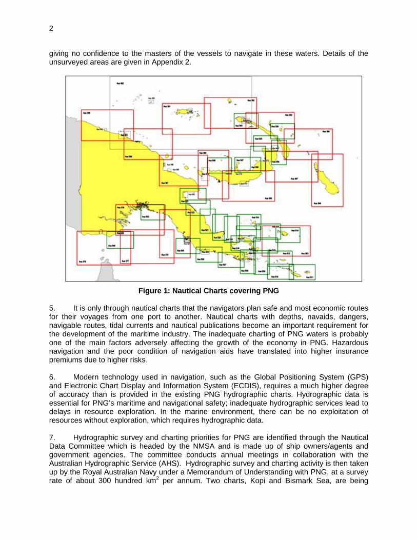
PNG: Maritime and Waterways Safety Project
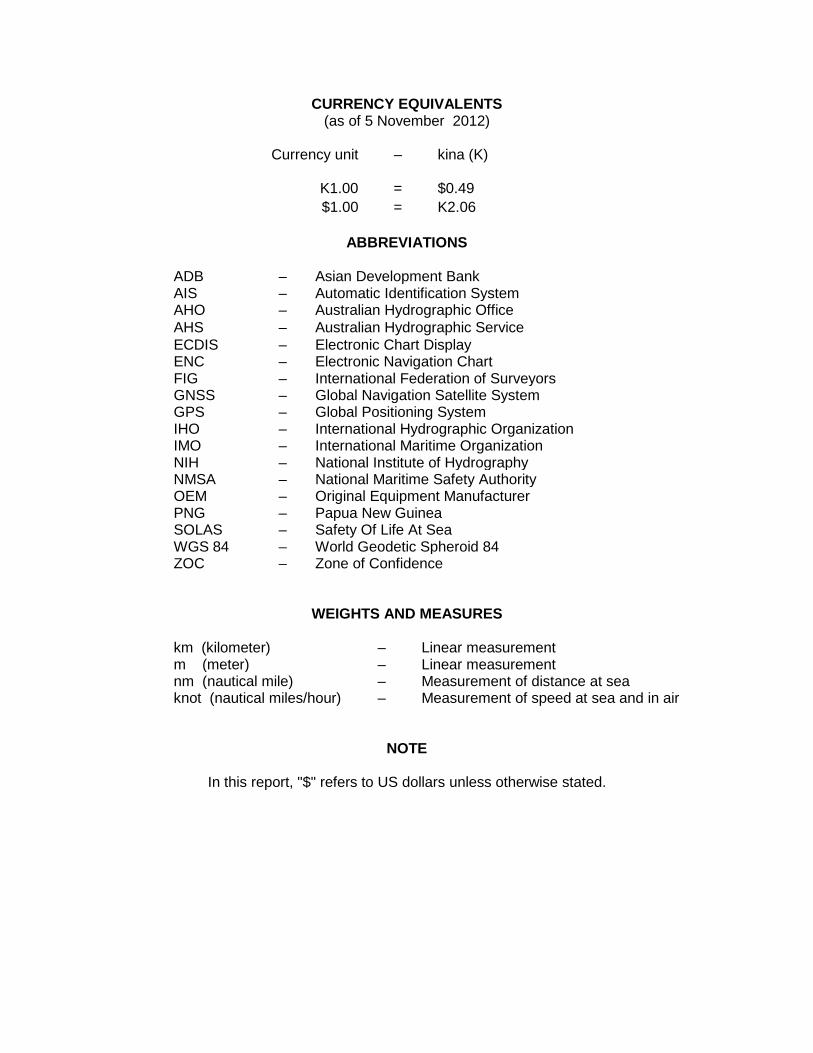
CURRENCY EQUIVALENTS (as of 5 November 2012)
Currency unit – kina (K)
K1.00 = $0.49 $1.00 = K2.06
ABBREVIATIONS
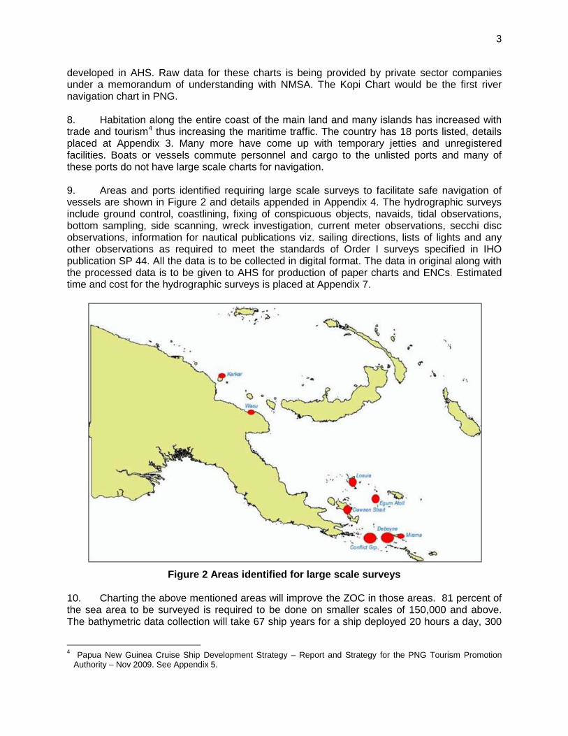
ADB – Asian Development Bank AIS – Automatic Identification System AHO – Australian Hydrographic Office AHS – Australian Hydrographic Service ECDIS – Electronic Chart Display ENC – Electronic Navigation Chart FIG – International Federation of Surveyors GNSS – Global Navigation Satellite System GPS – Global Positioning System IHO – International Hydrographic Organization IMO – International Maritime Organization NIH – National Institute of Hydrography NMSA – National Maritime Safety Authority OEM – Original Equipment Manufacturer PNG – Papua New Guinea SOLAS – Safety Of Life At Sea WGS 84 – World Geodetic Spheroid 84 ZOC – Zone of Confidence
WEIGHTS AND MEASURES
km (kilometer) – Linear measurement m (meter) – Linear measurement nm (nautical mile) – Measurement of distance at sea knot (nautical miles/hour) – Measurement of speed at sea and in air
NOTE
In this report, "$" refers to US dollars unless otherwise stated.
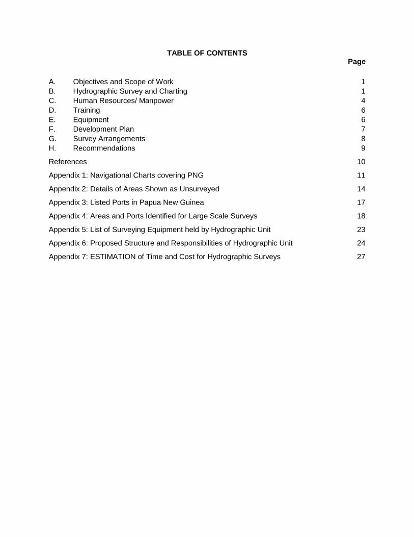
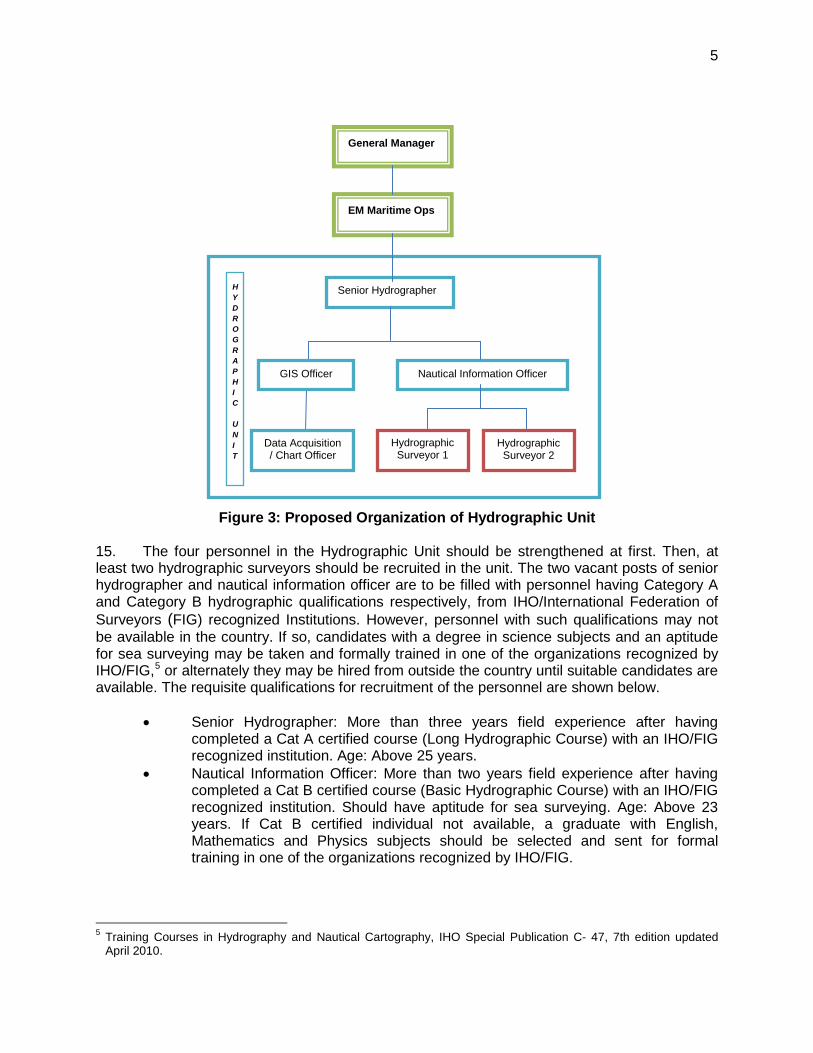
TABLE OF CONTENTS Page
A. Objectives and Scope of Work 1 B. Hydrographic Survey and Charting 1 C. Human Resources/ Manpower 4 D. Training 6 E. Equipment 6 F. Development Plan 7 G. Survey Arrangements 8 H. Recommendations 9
References 10
Appendix 1: Navigational Charts covering PNG 11
Appendix 2: Details of Areas Shown as Unsurveyed 14
Appendix 3: Listed Ports in Papua New Guinea 17
Appendix 4: Areas and Ports Identified for Large Scale Surveys 18
Appendix 5: List of Surveying Equipment held by Hydrographic Unit 23
Appendix 6: Proposed Structure and Responsibilities of Hydrographic Unit 24
Appendix 7: ESTIMATION of Time and Cost for Hydrographic Surveys 27

A. Objectives and Scope of Work
1. The independent state of Papua New Guinea (PNG) is occupying the eastern half of the island of New Guinea and numerous offshore islands in the South West Pacific Ocean. The country has 2.4 million square kilometer (km) of sea area with a coastline of about 21,700 km of which most is inadequately surveyed. Water transportation is the main mode of communication within the archipelago and affordable by the major community of the country. The main shipping lanes between Australia and North Asia also pass through these islands. As of today no charts are available for navigating the rivers. Two navigational charts are under production by data sharing arrangements with the private sector.1
2. By late 2005, the National Maritime Safety Authority (NMSA) was established which included a Hydrographic Unit responsible for sale and distribution of nautical charts and Notices to Mariners. The Hydrographic Unit has not been able to contribute to the updating of the existing navigational charts with real time surveys and making new charts on large scale for the developing ports. 3. About 90 percent of the world’s cargo is transported by sea relying on nautical charts. Consequently, most coastal countries place great importance on their coastal management and charting activities. NMSA also requires an improved transport control, monitoring and surveillance system (i.e., Automatic Identification System), meteorological sensors and wider coverage of hydrographic charts to reduce the risk of accidents, loss of lives and negative environmental impacts. To operate the new systems and extend the coverage of charts, it is necessary for NMSA to upgrade technical and management skills, while NMSA is in the process of establishing systems for more rigorous and quantitative monitoring. The proposed project to respond to those requirements is expected to produce benefits for remote rural population, as well as for national and international populations, by improving the nautical charts and publications for safe and efficient shipping services. B. Hydrographic Survey and Charting 4. Of the 2.4 million km2 of sea area, 19 percent has been surveyed adequately2. Eighty-one percent of the area has not been surveyed and subsequently cannot be used for maritime travel. Most of these are based on old hydrographic and geodetic surveys, which lack the modern international standards. A great number of shoals, reefs and other hazards to navigation may have been undetected at the time of the survey, as the data collected were sparse and scattered. The location of many off-lying islets may not be accurately positioned on these charts due to the limitations of the conventional survey methods used. All the nautical charts and electronic navigational charts (ENCs) of this entire area have been made on WGS 84 datum under an ADB project.3
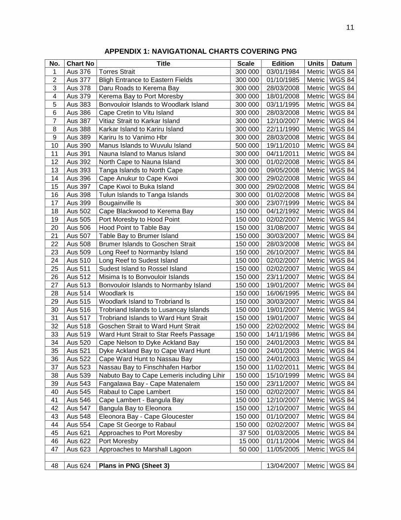
Appendix 1
With no additional or fresh hydrographic surveys, new charts with plans of harbors and approaches have been made, thus the result of Zone of confidence (ZOC) has been reduced. Figure 1 below shows the coverage of navigational charts in PNG. The colored boxes in the diagram below show the coverage of area and scale of the chart. A list of the nautical charts covering the PNG waters is provided in . They carry very little data required for vessels to navigate and anchor in the harbors. Most of the navigational charts carry pecked line contours and an area of 86,830 km2 (25,315 nm2) is shown “unsurveyed” 1 International Hydrographic Organization, South West Pacific Hydrographic Commission (SWPHC), 11th Meeting –
Brisbane, Australia, 15-16 February 2012; Papua New Guinea National Maritime Safety Authority, National Report. 2 IHO C-55 Status of Hydrographic Surveys Papua New Guinea updated 13 October 2008. 3 ADB. 2000. Report and Recommendation of the President to the Board of Directors: Proposed Loan to Papua New
Guinea for the Rehabilitation of the Maritime Navigation Aids System Project. Manila.
2
giving no confidence to the masters of the vessels to navigate in these waters. Details of the unsurveyed areas are given in Appendix 2.
Figure 1: Nautical Charts covering PNG
5. It is only through nautical charts that the navigators plan safe and most economic routes for their voyages from one port to another. Nautical charts with depths, navaids, dangers, navigable routes, tidal currents and nautical publications become an important requirement for the development of the maritime industry. The inadequate charting of PNG waters is probably one of the main factors adversely affecting the growth of the economy in PNG. Hazardous navigation and the poor condition of navigation aids have translated into higher insurance premiums due to higher risks. 6. Modern technology used in navigation, such as the Global Positioning System (GPS) and Electronic Chart Display and Information System (ECDIS), requires a much higher degree of accuracy than is provided in the existing PNG hydrographic charts. Hydrographic data is essential for PNG’s maritime and navigational safety; inadequate hydrographic services lead to delays in resource exploration. In the marine environment, there can be no exploitation of resources without exploration, which requires hydrographic data. 7. Hydrographic survey and charting priorities for PNG are identified through the Nautical Data Committee which is headed by the NMSA and is made up of ship owners/agents and government agencies. The committee conducts annual meetings in collaboration with the Australian Hydrographic Service (AHS). Hydrographic survey and charting activity is then taken up by the Royal Australian Navy under a Memorandum of Understanding with PNG, at a survey rate of about 300 hundred km2 per annum. Two charts, Kopi and Bismark Sea, are being
3
developed in AHS. Raw data for these charts is being provided by private sector companies under a memorandum of understanding with NMSA. The Kopi Chart would be the first river navigation chart in PNG. 8. Habitation along the entire coast of the main land and many islands has increased with trade and tourism4
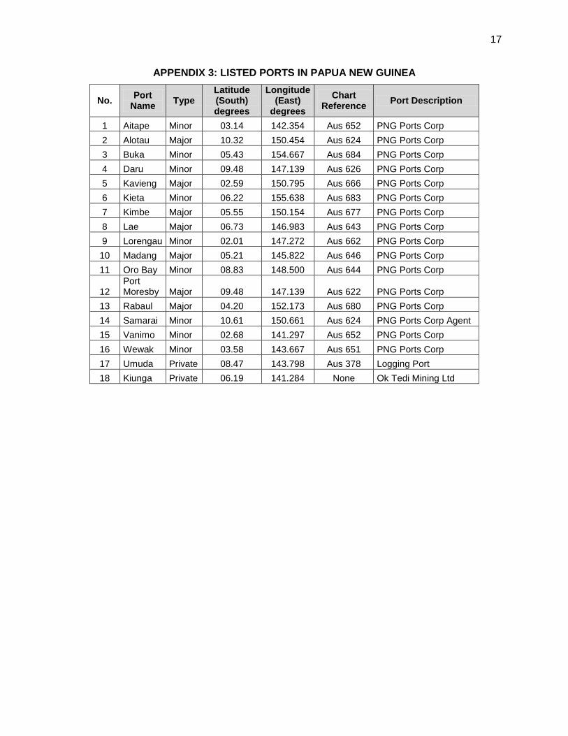
Appendix 3 thus increasing the maritime traffic. The country has 18 ports listed, details
placed at . Many more have come up with temporary jetties and unregistered facilities. Boats or vessels commute personnel and cargo to the unlisted ports and many of these ports do not have large scale charts for navigation. 9. Areas and ports identified requiring large scale surveys to facilitate safe navigation of vessels are shown in Figure 2 and details appended in Appendix 4. The hydrographic surveys include ground control, coastlining, fixing of conspicuous objects, navaids, tidal observations, bottom sampling, side scanning, wreck investigation, current meter observations, secchi disc observations, information for nautical publications viz. sailing directions, lists of lights and any other observations as required to meet the standards of Order I surveys specified in IHO publication SP 44. All the data is to be collected in digital format. The data in original along with the processed data is to be given to AHS for production of paper charts and ENCs. Estimated time and cost for the hydrographic surveys is placed at Appendix 7.
Figure 2 Areas identified for large scale surveys
10. Charting the above mentioned areas will improve the ZOC in those areas. 81 percent of the sea area to be surveyed is required to be done on smaller scales of 150,000 and above. The bathymetric data collection will take 67 ship years for a ship deployed 20 hours a day, 300
4 Papua New Guinea Cruise Ship Development Strategy – Report and Strategy for the PNG Tourism Promotion
Authority – Nov 2009. See Appendix 5.
4
days a year and cruising at 12 knots. This is to be taken up by outsourcing to private companies under the supervision of personnel of the Hydrographic Unit, NMSA. Efforts to update small scale charts should continue with the bathymetric data obtained from the research vessels carrying out surveys in PNG. 11. Following seven locations have been identified as having maximum vessel traffic transiting between Asia and Australia. The narrowest channel being transited is at Jomard Entrance, two and half nm wide. The existing navigational charts of these areas have adequate data for mariners’ safe passage and fresh surveys may not be required immediately. Details of the channels and their corresponding navigational charts are shown below:
• Vitiaz Strait - Vitiaz Strait to Karkar Island, AUS 387, 1:300,000 • Torbriand Islands - Woodlark Island to Torbirand Islands, AUS 515, 1:150,000 • Torbriand Islands to Lusancay Islands, AUS 516, 1:150,000 • Solomon Sea Long Reef to Normanby Island, AUS 509, 1:150,000 • Misima Island to Bonvouloir Islands, AUS 512, 1:15000 • Jomard Entrance - Long Reef to Sudest Island, AUS 510, 1:15,000 • East Coast of New Ireland - Tulun Islands to Tanga Islands, AUS 398, 1:300,000
C. Human Resources/ Manpower
12. The Hydrographic Unit of NMSA has two employees with no dedicated training in hydrography, whereas four persons are sanctioned. An officer with GIS background is presently heading the department, assisted by a data acquisition / charting officer, and both working in different buildings. The unit does not have a senior hydrographer and nautical information officer since June and May 2011 respectively. There is no continuous employment of dedicated personnel with hydrographic qualifications, looking after the hydrographic survey issues and upkeep of the data and the unit has not enhanced the hydrographic capability. 13. Stocks of navigational charts covering PNG are maintained and sold. Information received from port authorities, mariners and other agencies in PNG for issuance of Notices to Mariners is transmitted to the AHS for publication. Matters concerning hydrographic surveying, cartography and maintenance of the surveying equipment held by the unit, listed at Appendix 5, take least or no priority. This is mainly attributable to non-availability of personnel trained in hydrography. 14. The Hydrographic Unit needs to be strengthened to maintain IHO standards of nautical charts and publications. The unit should collect hydrographic survey data, manage the contract surveys, if outsourced and submit the data to AHS for updating the navigational charts and publications. Cartography and production of charts may be deferred until such time when the Hydrographic Unit has the expertise and gathered experience of at least 5 years in collecting hydrographic data to meet the standards of the International Hydrographic Organization (IHO). The GIS Officer and the Data Acquisition Officer should develop their cartographic expertise by availing of the processed data in the Hydrographic Unit. The proposed organization of the Hydrographic Unit is shown below. The proposed functions of the Hydrographic Unit and the charter of duties are provided in Appendix 6.
5
Figure 3: Proposed Organization of Hydrographic Unit
15. The four personnel in the Hydrographic Unit should be strengthened at first. Then, at least two hydrographic surveyors should be recruited in the unit. The two vacant posts of senior hydrographer and nautical information officer are to be filled with personnel having Category A and Category B hydrographic qualifications respectively, from IHO/International Federation of Surveyors (FIG) recognized Institutions. However, personnel with such qualifications may not be available in the country. If so, candidates with a degree in science subjects and an aptitude for sea surveying may be taken and formally trained in one of the organizations recognized by IHO/FIG,5
or alternately they may be hired from outside the country until suitable candidates are available. The requisite qualifications for recruitment of the personnel are shown below.
• Senior Hydrographer: More than three years field experience after having completed a Cat A certified course (Long Hydrographic Course) with an IHO/FIG recognized institution. Age: Above 25 years.
• Nautical Information Officer: More than two years field experience after having completed a Cat B certified course (Basic Hydrographic Course) with an IHO/FIG recognized institution. Should have aptitude for sea surveying. Age: Above 23 years. If Cat B certified individual not available, a graduate with English, Mathematics and Physics subjects should be selected and sent for formal training in one of the organizations recognized by IHO/FIG.
5 Training Courses in Hydrography and Nautical Cartography, IHO Special Publication C- 47, 7th edition updated
April 2010.
General Manager
EM Maritime Ops
Senior Hydrographer
Nautical Information Officer
HYDROGRAPHIC UNIT
GIS Officer
Data Acquisition / Chart Officer
Hydrographic Surveyor 1
Hydrographic Surveyor 2
6
• Hydrographic Surveyors: Should have passed pre degree with English, Mathematics and Physics subjects. Any polytechnic course in hydrographic surveying or land surveying would be an added qualification. Should have aptitude for sea surveying. Age: Above 18 years. Need to be imparted formal training in hydrography in one of the institutions recognized by IHO/FIG.
D. Training
16. IHO Special Publication C-47, 7th edition, updated April 2011 provides a summary of IHO approved training courses around the world. Formal training in hydrography is essential for personnel working in Hydrographic Unit. National Institute of Hydrography (NIH), Goa, India imparts training to civilians in hydrography. At least one course for each category is conducted every year. Nautical Information Officer and Hydrographic Surveyors have to undergo training of 10 weeks for Civilian Hydrographic Course and Civilian Sub-ordinate Staff Course respectively. Request for these courses need to be taken up through diplomatic channel. Cost of training individuals at NIH, Goa, India is estimated to be $65,000. The entry level qualifications required for undergoing the courses and training schedule for the year 2013 is appended below at Table 1. The individuals may be sent to these institutions for further formal training to acquire the requisite experience in the field of surveying.
Table 1: Hydrographic course for civilians at NIH
No. Category Entry level qualifications Date of
commence-ment
Date of completion
1
Civilian 'H' Officer’s refresher course
Bachelors degree in Physics and Mathematics or a degree in Civil Engineering or equivalent qualification with at least 02 years of experience in Hydrographic Surveying OR 08 years of experience in Hydrographic Surveying after completion of the Survey Recorder I class course. OR 12 years of experience in Hydrographic Surveying after completion of the Survey Recorder II class course. Must be employed as a Class II officer/Group B officer
11 Feb 13 20 Apr 13
2
Civilian Subordinate Staff Course
Intermediate/Higher Secondary (10+2) OR equivalent with Physics and Mathematics and at least two years of experience in Hydrographic Surveying
04 Feb 13 13 Apr 13
E. Equipment
17. The Hydrographic Unit of NMSA needs to build its capability to conduct hydrographic surveys independently. Conduct of hydrographic surveys includes planning, execution and rendering of the data sets in the requisite formats for printing of nautical charts and publications. The equipment held by the Hydrographic Unit, listed at Appendix 5, has been lying untouched
7
for more than two years and may require repair and calibration for deployment. The cost for making these equipment operational with latest technology would be expensive. Following surveying equipment and a Survey Motor Boat will be the basic requirement for conducting hydrographic surveys and it is proposed to procure the same during second year of the project by when the Hydrographic Unit will have personnel trained in hydrography and will be in a position to deploy the same for collecting the bathymetric data. All the equipment will be portable for ease of mobility and deployment from any platform. Estimated cost of survey motor boat is $50,000 and cost of the survey equipment is $589,000 as appended below:
Table 2: Cost of Surveying Equipment
Cost of Surveying Equipment
No. Equipment Make Denomi- nation Quantity
Estimated cost in $000’s
1 Echo Sounder dual channel Odom LS One 100
2 Echo Sounder dual channel Ceeducer LS One 26
3 Roll Pitch and Heave motion sensor IX Sea LS One 130
4 Differential GPS Trimble LS One 26
5 Land Surveying system
Navcom RTK with radio link LS One 66
6 Automatic tide gauge Valeport LS One 26 7 Side Scan sonar Edgetech LS One 131 8 Current Meter Anderaa LS One 50 9 Bottom samplers Indian Make Unit. Two 4
10 Data acquisition and processing software
Hypack & Hysweep LS. Two 17
11 Lap top for data acquisition Unit. One 3
12 Desk top computer with plotter and printer LS. One 10
Total cost 589
F. Development Plan
18. The Hydrographic Unit needs to have its own team, premises, equipment and mobility to enable collection of hydrographic data. Building of the entire structure would be over a period of five years as mentioned below.
8
Table 3: Year wise development plan
First year • Recruitment of personnel as proposed at paragraph 15 above.
• Training of personnel in hydrography. • Initiate action for procurement of equipment. • Outsource surveys of harbors/areas proposed above
Second year • Procurement of equipment and trials of the equipment. • Training by the Original Equipment Manufacturer (OEM)
on the use of equipment for data acquisition and post processing.
• Independent deployment of equipment for data acquisition and processing.
• Initiate action for acquiring a survey Motor Boat. • Outsource surveys of unsurveyed areas.
Third to Fifth year
• Plan and conduct surveys of coastal waters • Manage the outsourced contract surveys for QA and QC. • Provide the processed data to AHS for production of
navigational charts and ENCs.
G. Survey Arrangements
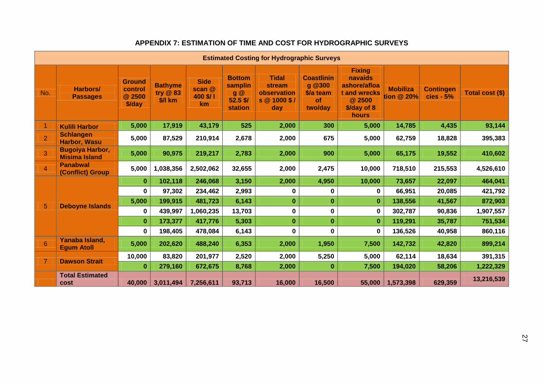
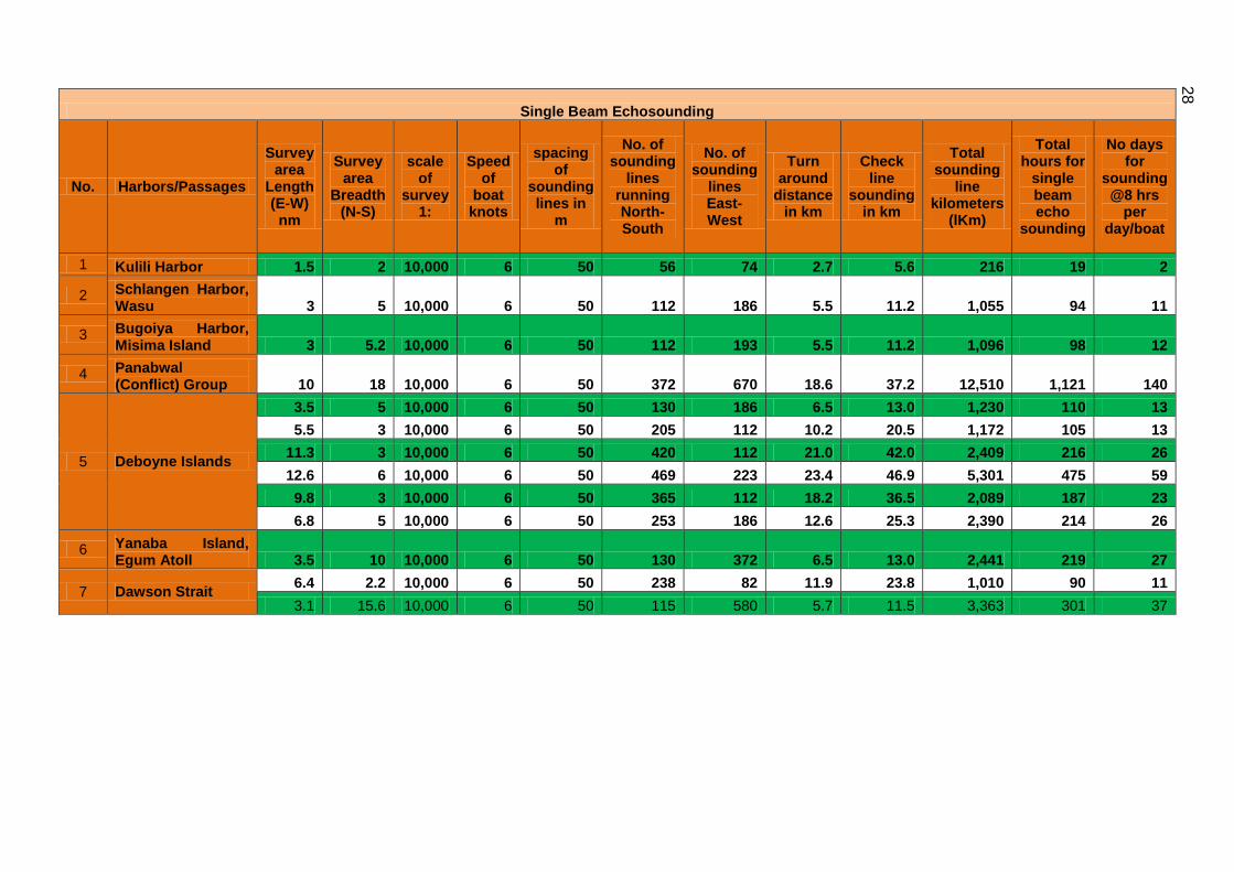
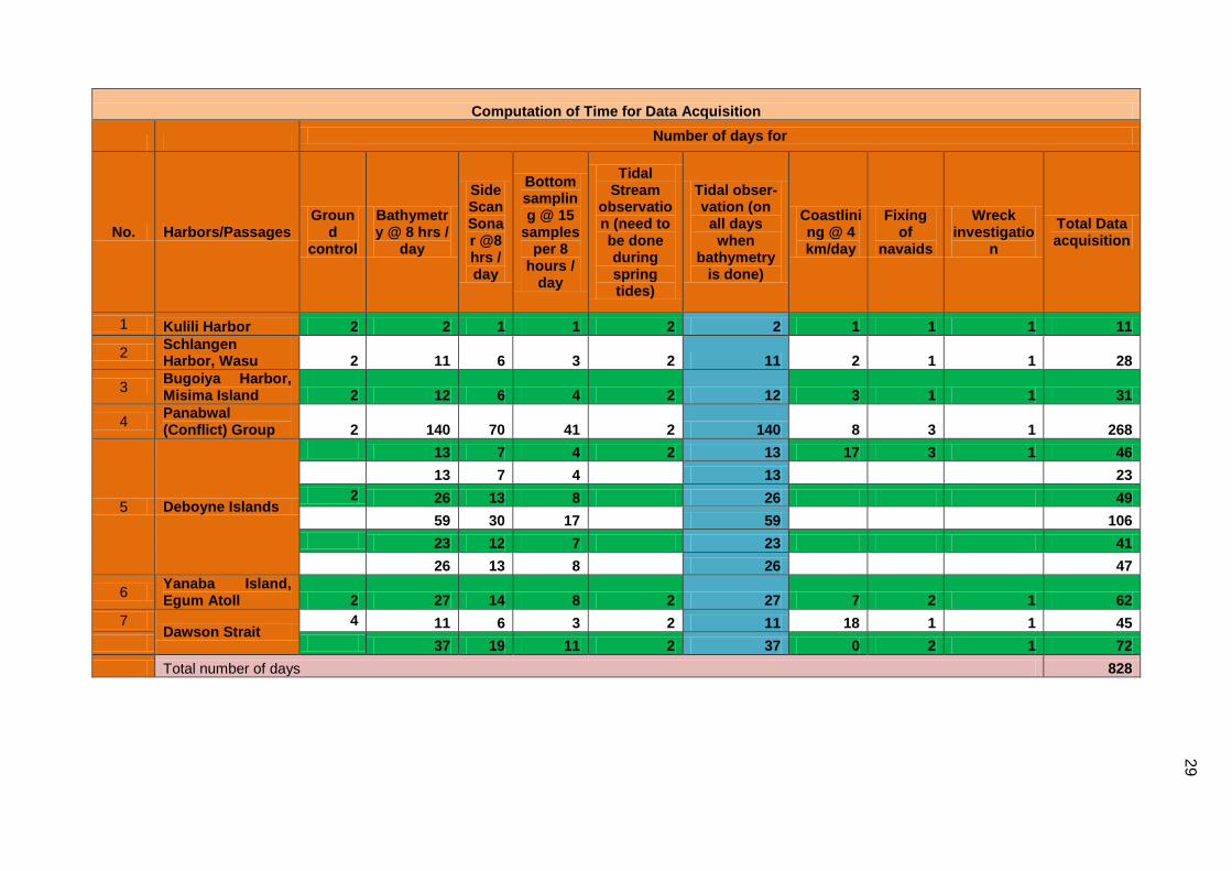
19. Areas and ports identified requiring large scale surveys to be taken up in the current project are appended below in the order of priority. All the surveys are to be carried out on a scale of 1:10000, WGS 84 Spheroid and plotted on UTM Grid. The hydrographic surveys include ground control, coastlining, fixing of conspicuous objects, navaids, tidal observations, bottom sampling, side scanning, wreck investigation, current meter observations, secchi disc observations, information for nautical publications viz. sailing directions, lists of lights and any other observations as required to meet the standards of Order I surveys specified in IHO publication SP 44. Chart datum to be established in all the survey areas either by transfer of datum or from the tidal observations carried out. All the soundings to be reduced to chart datum. All the data are to be collected in digital format. A copy of the original data along with the processed data is to be given to AHS for production of paper charts and ENCs. Estimated cost, time taken for data acquisition and submission of deliverables is appended against each area in Table 4 below: and working out details placed at Appendix 7.
Table 4: Cost and Time for proposed Hydrographic Surveys
No. Area/port Cost ($) Time for Data acquisition
(Days)
Time for post processing
(Days) 1 Kulili Harbor 93,000 9 15 2 Schlangen Harbor, Wasu 395,000 26 15
3 Bugoiya Harbor, Misima Island 411,000 29 15
4 Panabwal (Conflict) Group 4,527,000 266 45 5 Deboyne Islands 5,278,000 310 45 6 Yanaba Island, Egum Atoll 899,000 41 30
9
No. Area/port Cost ($) Time for Data acquisition
(Days)
Time for post processing
(Days) 7 Dawson Strait 1,614,000 72 30
Total 13,217,000 753 195 Note: Losuia, Kiriwina Island was deleted from the list of surveys proposed. A new chart for the area is under preparation at AHS.
20. The hydrographic survey operations in no way raise any social or environmental issues but may restrict the fishing and laying of nets in shallow waters to enable the sounding boats to maneuver in restricted and shallow waters. 21. The Community Development department of NMSA needs to promulgate the survey programs and bring awareness among the fishing community. Further the schedule of the sounding operations will have to be published in the local media. H. Recommendations
22. PNG with a vast area of sea and coastline needs to accord priority and emphasis in developing the hydrographic capability within the country to fulfill the obligations of the government to render hydrographic services in accordance with International Maritime Organization conventions.6
Water transportation the main mode of communication within the archipelago and affordable by the major community of the country makes it more important for having own sources of hydrographic services. Availability of detailed nautical charts and publications enhances confidence in the mariners to make voyages for trade and tourism. Comprehensive capability of the Hydrographic Unit would be achieved over a period of 5 years with dedicated personnel, equipment and technology. Production of navigational charts and ENCs would follow with experience in hydrography and cartography over a period of ten years or more. The followings are recommended:
• Strengthening the Hydrographic Unit by filling the two vacant positions and recruiting two additional personnel (para. 15).
• Dedicated training in hydrography to be imparted to the incumbents (para. 16). • Procurement of surveying equipment and survey motor boat (para. 17). • Outsourcing of hydrographic surveys (para. 19).
6 International Maritime Organisation, SOLAS (Safety of Life At Sea) convention, Chapter V – Safety of Navigation,
Regulation 9 – Hydrogrphic services.
10
REFERENCES
1) Papua New Guinea Cruise Ship Development Strategy – Report and Strategy for the PNG Tourism Promotion Authority – Nov 2009. (Appendix 5).
2) Papua New Guinea Hydrographic Service (PNGHS) and the Future – Papua New Guinea Hydrographic Service an Ant with the Giants, By J. Kunda, PNG.
3) Australian Seafarers Handbook 4) Hydrographic program 2013-20. 5) AHS - Survey Summary F_05_51_AA217163_(NOV 11). 6) Training Courses in Hydrography and Nautical Cartography - HO Special Publication C-47,
7th edition updated April 2011.
11
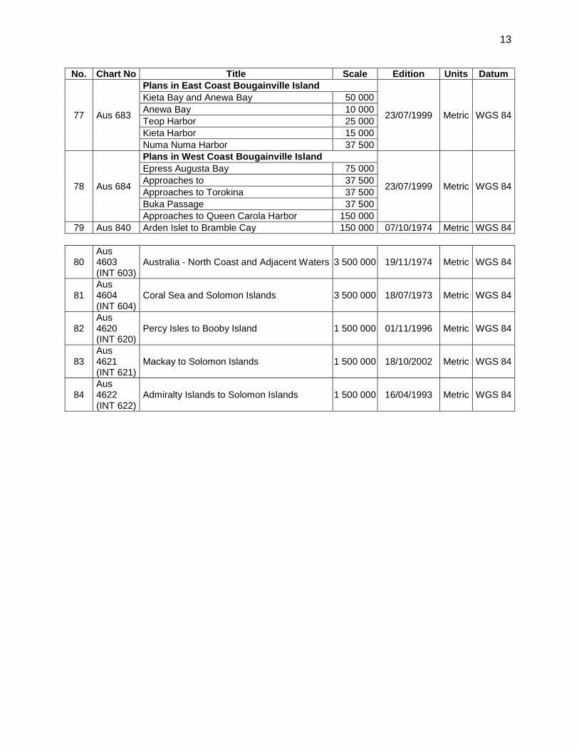
APPENDIX 1: NAVIGATIONAL CHARTS COVERING PNG No. Chart No Title Scale Edition Units Datum 1 Aus 376 Torres Strait 300 000 03/01/1984 Metric WGS 84 2 Aus 377 Bligh Entrance to Eastern Fields 300 000 01/10/1985 Metric WGS 84 3 Aus 378 Daru Roads to Kerema Bay 300 000 28/03/2008 Metric WGS 84 4 Aus 379 Kerema Bay to Port Moresby 300 000 18/01/2008 Metric WGS 84 5 Aus 383 Bonvouloir Islands to Woodlark Island 300 000 03/11/1995 Metric WGS 84 6 Aus 386 Cape Cretin to Vitu Island 300 000 28/03/2008 Metric WGS 84 7 Aus 387 Vitiaz Strait to Karkar Island 300 000 12/10/2007 Metric WGS 84 8 Aus 388 Karkar Island to Kariru Island 300 000 22/11/1990 Metric WGS 84 9 Aus 389 Kariru Is to Vanimo Hbr 300 000 28/03/2008 Metric WGS 84 10 Aus 390 Manus Islands to Wuvulu Island 500 000 19/11/2010 Metric WGS 84 11 Aus 391 Nauna Island to Manus Island 300 000 04/11/2011 Metric WGS 84 12 Aus 392 North Cape to Nauna Island 300 000 01/02/2008 Metric WGS 84 13 Aus 393 Tanga Islands to North Cape 300 000 09/05/2008 Metric WGS 84 14 Aus 396 Cape Anukur to Cape Kwoi 300 000 29/02/2008 Metric WGS 84 15 Aus 397 Cape Kwoi to Buka Island 300 000 29/02/2008 Metric WGS 84 16 Aus 398 Tulun Islands to Tanga Islands 300 000 01/02/2008 Metric WGS 84 17 Aus 399 Bougainville Is 300 000 23/07/1999 Metric WGS 84 18 Aus 502 Cape Blackwood to Kerema Bay 150 000 04/12/1992 Metric WGS 84 19 Aus 505 Port Moresby to Hood Point 150 000 02/02/2007 Metric WGS 84 20 Aus 506 Hood Point to Table Bay 150 000 31/08/2007 Metric WGS 84 21 Aus 507 Table Bay to Brumer Island 150 000 30/03/2007 Metric WGS 84 22 Aus 508 Brumer Islands to Goschen Strait 150 000 28/03/2008 Metric WGS 84 23 Aus 509 Long Reef to Normanby Island 150 000 26/10/2007 Metric WGS 84 24 Aus 510 Long Reef to Sudest Island 150 000 02/02/2007 Metric WGS 84 25 Aus 511 Sudest Island to Rossel Island 150 000 02/02/2007 Metric WGS 84 26 Aus 512 Misima Is to Bonvouloir Islands 150 000 23/11/2007 Metric WGS 84 27 Aus 513 Bonvouloir Islands to Normanby Island 150 000 19/01/2007 Metric WGS 84 28 Aus 514 Woodlark Is 150 000 16/06/1995 Metric WGS 84 29 Aus 515 Woodlark Island to Trobriand Is 150 000 30/03/2007 Metric WGS 84 30 Aus 516 Trobriand Islands to Lusancay Islands 150 000 19/01/2007 Metric WGS 84 31 Aus 517 Trobriand Islands to Ward Hunt Strait 150 000 19/01/2007 Metric WGS 84 32 Aus 518 Goschen Strait to Ward Hunt Strait 150 000 22/02/2002 Metric WGS 84 33 Aus 519 Ward Hunt Strait to Star Reefs Passage 150 000 14/11/1986 Metric WGS 84 34 Aus 520 Cape Nelson to Dyke Ackland Bay 150 000 24/01/2003 Metric WGS 84 35 Aus 521 Dyke Ackland Bay to Cape Ward Hunt 150 000 24/01/2003 Metric WGS 84 36 Aus 522 Cape Ward Hunt to Nassau Bay 150 000 24/01/2003 Metric WGS 84 37 Aus 523 Nassau Bay to Finschhafen Harbor 150 000 11/02/2011 Metric WGS 84 38 Aus 539 Nabuto Bay to Cape Lemeris including Lihir 150 000 15/10/1999 Metric WGS 84 39 Aus 543 Fangalawa Bay - Cape Matenalem 150 000 23/11/2007 Metric WGS 84 40 Aus 545 Rabaul to Cape Lambert 150 000 02/02/2007 Metric WGS 84 41 Aus 546 Cape Lambert - Bangula Bay 150 000 12/10/2007 Metric WGS 84 42 Aus 547 Bangula Bay to Eleonora 150 000 12/10/2007 Metric WGS 84 43 Aus 548 Eleonora Bay - Cape Gloucester 150 000 01/10/2007 Metric WGS 84 44 Aus 554 Cape St George to Rabaul 150 000 02/02/2007 Metric WGS 84 45 Aus 621 Approaches to Port Moresby 37 500 01/03/2005 Metric WGS 84 46 Aus 622 Port Moresby 15 000 01/11/2004 Metric WGS 84 47 Aus 623 Approaches to Marshall Lagoon 50 000 11/05/2005 Metric WGS 84
48 Aus 624 Plans in PNG (Sheet 3) 13/04/2007 Metric WGS 84
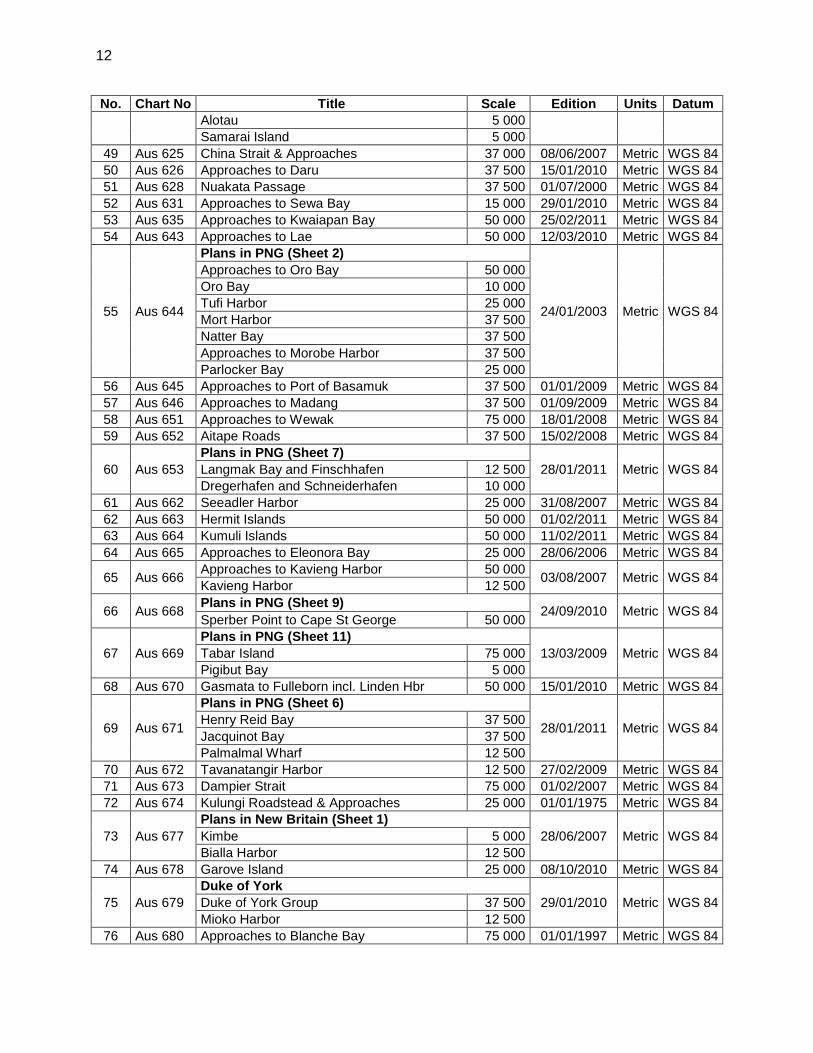
12
No. Chart No Title Scale Edition Units Datum Alotau 5 000 Samarai Island 5 000
49 Aus 625 China Strait & Approaches 37 000 08/06/2007 Metric WGS 84 50 Aus 626 Approaches to Daru 37 500 15/01/2010 Metric WGS 84 51 Aus 628 Nuakata Passage 37 500 01/07/2000 Metric WGS 84 52 Aus 631 Approaches to Sewa Bay 15 000 29/01/2010 Metric WGS 84 53 Aus 635 Approaches to Kwaiapan Bay 50 000 25/02/2011 Metric WGS 84 54 Aus 643 Approaches to Lae 50 000 12/03/2010 Metric WGS 84
55 Aus 644
Plans in PNG (Sheet 2)
24/01/2003 Metric WGS 84
Approaches to Oro Bay 50 000 Oro Bay 10 000 Tufi Harbor 25 000 Mort Harbor 37 500 Natter Bay 37 500 Approaches to Morobe Harbor 37 500 Parlocker Bay 25 000
56 Aus 645 Approaches to Port of Basamuk 37 500 01/01/2009 Metric WGS 84 57 Aus 646 Approaches to Madang 37 500 01/09/2009 Metric WGS 84 58 Aus 651 Approaches to Wewak 75 000 18/01/2008 Metric WGS 84 59 Aus 652 Aitape Roads 37 500 15/02/2008 Metric WGS 84
60 Aus 653 Plans in PNG (Sheet 7)
28/01/2011 Metric WGS 84 Langmak Bay and Finschhafen 12 500 Dregerhafen and Schneiderhafen 10 000
61 Aus 662 Seeadler Harbor 25 000 31/08/2007 Metric WGS 84 62 Aus 663 Hermit Islands 50 000 01/02/2011 Metric WGS 84 63 Aus 664 Kumuli Islands 50 000 11/02/2011 Metric WGS 84 64 Aus 665 Approaches to Eleonora Bay 25 000 28/06/2006 Metric WGS 84
65 Aus 666 Approaches to Kavieng Harbor 50 000 03/08/2007 Metric WGS 84 Kavieng Harbor 12 500
66 Aus 668 Plans in PNG (Sheet 9) 24/09/2010 Metric WGS 84 Sperber Point to Cape St George 50 000
67 Aus 669 Plans in PNG (Sheet 11)
13/03/2009 Metric WGS 84 Tabar Island 75 000 Pigibut Bay 5 000
68 Aus 670 Gasmata to Fulleborn incl. Linden Hbr 50 000 15/01/2010 Metric WGS 84
69 Aus 671
Plans in PNG (Sheet 6)
28/01/2011 Metric WGS 84 Henry Reid Bay 37 500 Jacquinot Bay 37 500 Palmalmal Wharf 12 500
70 Aus 672 Tavanatangir Harbor 12 500 27/02/2009 Metric WGS 84 71 Aus 673 Dampier Strait 75 000 01/02/2007 Metric WGS 84 72 Aus 674 Kulungi Roadstead & Approaches 25 000 01/01/1975 Metric WGS 84
73 Aus 677 Plans in New Britain (Sheet 1)
28/06/2007 Metric WGS 84 Kimbe 5 000 Bialla Harbor 12 500
74 Aus 678 Garove Island 25 000 08/10/2010 Metric WGS 84
75 Aus 679 Duke of York
29/01/2010 Metric WGS 84 Duke of York Group 37 500 Mioko Harbor 12 500
76 Aus 680 Approaches to Blanche Bay 75 000 01/01/1997 Metric WGS 84
13
No. Chart No Title Scale Edition Units Datum
77 Aus 683
Plans in East Coast Bougainville Island
23/07/1999 Metric WGS 84
Kieta Bay and Anewa Bay 50 000 Anewa Bay 10 000 Teop Harbor 25 000 Kieta Harbor 15 000 Numa Numa Harbor 37 500
78 Aus 684
Plans in West Coast Bougainville Island
23/07/1999 Metric WGS 84
Epress Augusta Bay 75 000 Approaches to 37 500 Approaches to Torokina 37 500 Buka Passage 37 500 Approaches to Queen Carola Harbor 150 000
79 Aus 840 Arden Islet to Bramble Cay 150 000 07/10/1974 Metric WGS 84
80 Aus 4603 (INT 603)
Australia - North Coast and Adjacent Waters 3 500 000 19/11/1974 Metric WGS 84
81 Aus 4604 (INT 604)
Coral Sea and Solomon Islands 3 500 000 18/07/1973 Metric WGS 84
82 Aus 4620 (INT 620)
Percy Isles to Booby Island 1 500 000 01/11/1996 Metric WGS 84
83 Aus 4621 (INT 621)
Mackay to Solomon Islands 1 500 000 18/10/2002 Metric WGS 84
84 Aus 4622 (INT 622)
Admiralty Islands to Solomon Islands 1 500 000 16/04/1993 Metric WGS 84
14
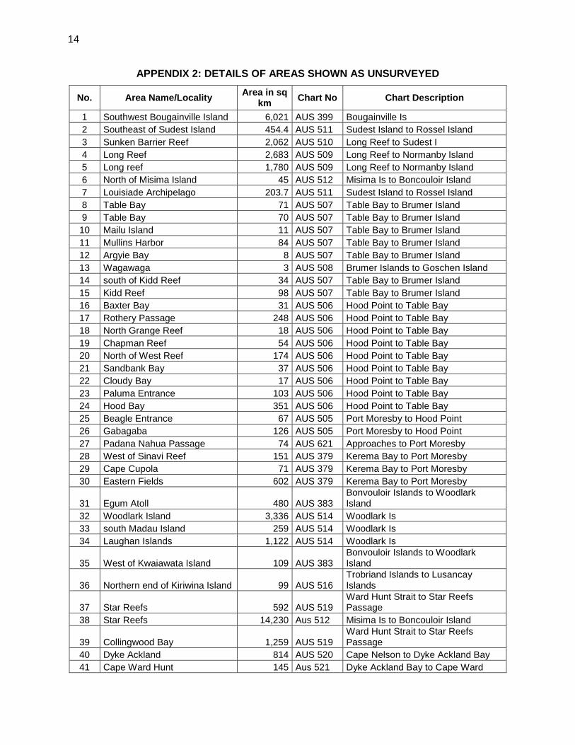
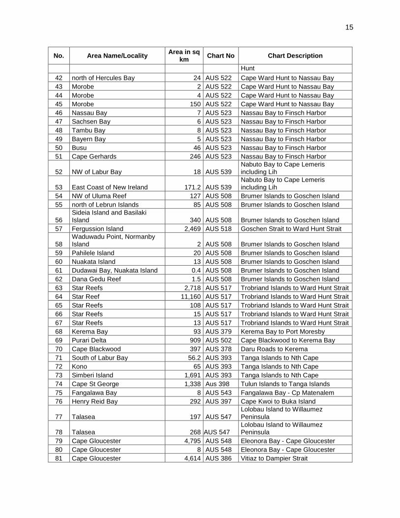
APPENDIX 2: DETAILS OF AREAS SHOWN AS UNSURVEYED
No. Area Name/Locality Area in sq km Chart No Chart Description
1 Southwest Bougainville Island 6,021 AUS 399 Bougainville Is 2 Southeast of Sudest Island 454.4 AUS 511 Sudest Island to Rossel Island 3 Sunken Barrier Reef 2,062 AUS 510 Long Reef to Sudest I 4 Long Reef 2,683 AUS 509 Long Reef to Normanby Island 5 Long reef 1,780 AUS 509 Long Reef to Normanby Island 6 North of Misima Island 45 AUS 512 Misima Is to Boncouloir Island 7 Louisiade Archipelago 203.7 AUS 511 Sudest Island to Rossel Island 8 Table Bay 71 AUS 507 Table Bay to Brumer Island 9 Table Bay 70 AUS 507 Table Bay to Brumer Island 10 Mailu Island 11 AUS 507 Table Bay to Brumer Island 11 Mullins Harbor 84 AUS 507 Table Bay to Brumer Island 12 Argyie Bay 8 AUS 507 Table Bay to Brumer Island 13 Wagawaga 3 AUS 508 Brumer Islands to Goschen Island 14 south of Kidd Reef 34 AUS 507 Table Bay to Brumer Island 15 Kidd Reef 98 AUS 507 Table Bay to Brumer Island 16 Baxter Bay 31 AUS 506 Hood Point to Table Bay 17 Rothery Passage 248 AUS 506 Hood Point to Table Bay 18 North Grange Reef 18 AUS 506 Hood Point to Table Bay 19 Chapman Reef 54 AUS 506 Hood Point to Table Bay 20 North of West Reef 174 AUS 506 Hood Point to Table Bay 21 Sandbank Bay 37 AUS 506 Hood Point to Table Bay 22 Cloudy Bay 17 AUS 506 Hood Point to Table Bay 23 Paluma Entrance 103 AUS 506 Hood Point to Table Bay 24 Hood Bay 351 AUS 506 Hood Point to Table Bay 25 Beagle Entrance 67 AUS 505 Port Moresby to Hood Point 26 Gabagaba 126 AUS 505 Port Moresby to Hood Point 27 Padana Nahua Passage 74 AUS 621 Approaches to Port Moresby 28 West of Sinavi Reef 151 AUS 379 Kerema Bay to Port Moresby 29 Cape Cupola 71 AUS 379 Kerema Bay to Port Moresby 30 Eastern Fields 602 AUS 379 Kerema Bay to Port Moresby
31 Egum Atoll 480 AUS 383 Bonvouloir Islands to Woodlark Island
32 Woodlark Island 3,336 AUS 514 Woodlark Is 33 south Madau Island 259 AUS 514 Woodlark Is 34 Laughan Islands 1,122 AUS 514 Woodlark Is
35 West of Kwaiawata Island 109 AUS 383 Bonvouloir Islands to Woodlark Island
36 Northern end of Kiriwina Island 99 AUS 516 Trobriand Islands to Lusancay Islands
37 Star Reefs 592 AUS 519 Ward Hunt Strait to Star Reefs Passage
38 Star Reefs 14,230 Aus 512 Misima Is to Boncouloir Island
39 Collingwood Bay 1,259 AUS 519 Ward Hunt Strait to Star Reefs Passage
40 Dyke Ackland 814 AUS 520 Cape Nelson to Dyke Ackland Bay 41 Cape Ward Hunt 145 Aus 521 Dyke Ackland Bay to Cape Ward
15
No. Area Name/Locality Area in sq km Chart No Chart Description
Hunt 42 north of Hercules Bay 24 AUS 522 Cape Ward Hunt to Nassau Bay 43 Morobe 2 AUS 522 Cape Ward Hunt to Nassau Bay 44 Morobe 4 AUS 522 Cape Ward Hunt to Nassau Bay 45 Morobe 150 AUS 522 Cape Ward Hunt to Nassau Bay 46 Nassau Bay 7 AUS 523 Nassau Bay to Finsch Harbor 47 Sachsen Bay 6 AUS 523 Nassau Bay to Finsch Harbor 48 Tambu Bay 8 AUS 523 Nassau Bay to Finsch Harbor 49 Bayern Bay 5 AUS 523 Nassau Bay to Finsch Harbor 50 Busu 46 AUS 523 Nassau Bay to Finsch Harbor 51 Cape Gerhards 246 AUS 523 Nassau Bay to Finsch Harbor
52 NW of Labur Bay 18 AUS 539 Nabuto Bay to Cape Lemeris including Lih
53 East Coast of New Ireland 171.2 AUS 539 Nabuto Bay to Cape Lemeris including Lih
54 NW of Uluma Reef 127 AUS 508 Brumer Islands to Goschen Island 55 north of Lebrun Islands 85 AUS 508 Brumer Islands to Goschen Island
56 Sideia Island and Basilaki Island 340 AUS 508 Brumer Islands to Goschen Island
57 Fergussion Island 2,469 AUS 518 Goschen Strait to Ward Hunt Strait
58 Waduwadu Point, Normanby Island 2 AUS 508 Brumer Islands to Goschen Island
59 Pahilele Island 20 AUS 508 Brumer Islands to Goschen Island 60 Nuakata Island 13 AUS 508 Brumer Islands to Goschen Island 61 Dudawai Bay, Nuakata Island 0.4 AUS 508 Brumer Islands to Goschen Island 62 Dana Gedu Reef 1.5 AUS 508 Brumer Islands to Goschen Island 63 Star Reefs 2,718 AUS 517 Trobriand Islands to Ward Hunt Strait 64 Star Reef 11,160 AUS 517 Trobriand Islands to Ward Hunt Strait 65 Star Reefs 108 AUS 517 Trobriand Islands to Ward Hunt Strait 66 Star Reefs 15 AUS 517 Trobriand Islands to Ward Hunt Strait 67 Star Reefs 13 AUS 517 Trobriand Islands to Ward Hunt Strait 68 Kerema Bay 93 AUS 379 Kerema Bay to Port Moresby 69 Purari Delta 909 AUS 502 Cape Blackwood to Kerema Bay 70 Cape Blackwood 397 AUS 378 Daru Roads to Kerema 71 South of Labur Bay 56.2 AUS 393 Tanga Islands to Nth Cape 72 Kono 65 AUS 393 Tanga Islands to Nth Cape 73 Simberi Island 1,691 AUS 393 Tanga Islands to Nth Cape 74 Cape St George 1,338 Aus 398 Tulun Islands to Tanga Islands 75 Fangalawa Bay 8 AUS 543 Fangalawa Bay - Cp Matenalem 76 Henry Reid Bay 292 AUS 397 Cape Kwoi to Buka Island
77 Talasea 197 AUS 547 Lolobau Island to Willaumez Peninsula
78 Talasea 268 AUS 547 Lolobau Island to Willaumez Peninsula
79 Cape Gloucester 4,795 AUS 548 Eleonora Bay - Cape Gloucester 80 Cape Gloucester 8 AUS 548 Eleonora Bay - Cape Gloucester 81 Cape Gloucester 4,614 AUS 386 Vitiaz to Dampier Strait
16
No. Area Name/Locality Area in sq km Chart No Chart Description
82 Umboi Island 783 AUS 387 Vitiaz Strait to Karkar Island 83 NW of Basamuk 50 Aus 645 Approaches to Port of Basamuk 84 Vitiaz Strait 1,389 Aus 386 Vitiaz to Dampier Strait 85 north coast mainland 312 Aus 387 Vitiaz Strait to Karkar Island 86 Broken Water Bay 137 AUS 462 Nth Cape, NI to Wuvulu Is 87 Kravel Bay 323 Aus 462 Nth Cape, NI to Wuvulu Is 88 Kariru island 15 AUS 462 Nth Cape, NI to Wuvulu Is 89 Muschu Island 4 AUS 462 Nth Cape, NI to Wuvulu Is 90 Keresau Island 2 AUS 462 Nth Cape, NI to Wuvulu Is 91 Logn Island 440 Aus 387 Vitiaz Strait to Karkar Island 92 Tolokiwa Island 124 Aus 387 Vitiaz Strait to Karkar Island 93 Crown Island 70 Aus 387 Vitiaz Strait to Karkar Island 94 Pak Island 470 Aus 391 Nauna Island to Manus Island 95 Rambutyo Island 1,363 AUS 462 Nth Cape, NI to Wuvulu Is 96 Malai Bay 504 AUS 462 Nth Cape, NI to Wuvulu Is 97 Bipi Island 1,396 AUS 462 Nth Cape, NI to Wuvulu Is 98 Kali Bay 422 AUS 462 Nth Cape, NI to Wuvulu Is 99 Seleo Island 109 AUS 389 Kariru Is to Vanimo Hbr 100 Nuguria Island 2,311 Aus 398 Tulun Islands to Tanga Islands 101 Marshall Bennett Islands 290 AUS 515 Woodlark Island to Trobriand Is 102 north of Woodlark Island 3,054 AUS 515 Woodlark Island to Trobriand Is 103 Mussau Island 2,466 AUS 392 North Cape to Nauna Island 104 Awio Bay 108 AUS 396 Cape Anukur to Cape Kwoi
Total area 86,829
17
APPENDIX 3: LISTED PORTS IN PAPUA NEW GUINEA
No. Port Name Type
Latitude (South) degrees
Longitude (East)
degrees
Chart Reference Port Description
1 Aitape Minor 03.14 142.354 Aus 652 PNG Ports Corp 2 Alotau Major 10.32 150.454 Aus 624 PNG Ports Corp 3 Buka Minor 05.43 154.667 Aus 684 PNG Ports Corp 4 Daru Minor 09.48 147.139 Aus 626 PNG Ports Corp 5 Kavieng Major 02.59 150.795 Aus 666 PNG Ports Corp 6 Kieta Minor 06.22 155.638 Aus 683 PNG Ports Corp 7 Kimbe Major 05.55 150.154 Aus 677 PNG Ports Corp 8 Lae Major 06.73 146.983 Aus 643 PNG Ports Corp 9 Lorengau Minor 02.01 147.272 Aus 662 PNG Ports Corp 10 Madang Major 05.21 145.822 Aus 646 PNG Ports Corp 11 Oro Bay Minor 08.83 148.500 Aus 644 PNG Ports Corp
12 Port Moresby Major 09.48 147.139 Aus 622 PNG Ports Corp
13 Rabaul Major 04.20 152.173 Aus 680 PNG Ports Corp 14 Samarai Minor 10.61 150.661 Aus 624 PNG Ports Corp Agent 15 Vanimo Minor 02.68 141.297 Aus 652 PNG Ports Corp 16 Wewak Minor 03.58 143.667 Aus 651 PNG Ports Corp 17 Umuda Private 08.47 143.798 Aus 378 Logging Port 18 Kiunga Private 06.19 141.284 None Ok Tedi Mining Ltd
18
APPENDIX 4: AREAS AND PORTS IDENTIFIED FOR LARGE SCALE SURVEYS
No. Location Latitude (S) Longitude (E) Reason
for survey
Affected Chart
No. From To From To
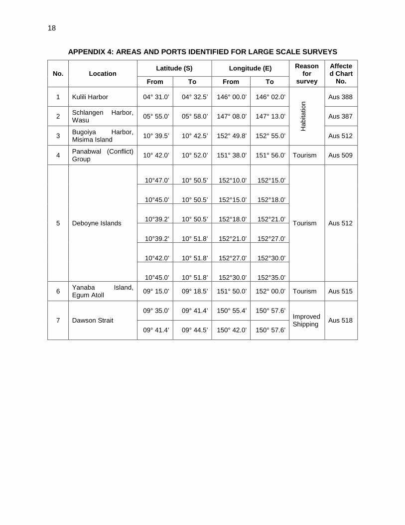
1 Kulili Harbor 04° 31.0’ 04° 32.5’ 146° 00.0’ 146° 02.0’
Hab
itatio
n
Aus 388
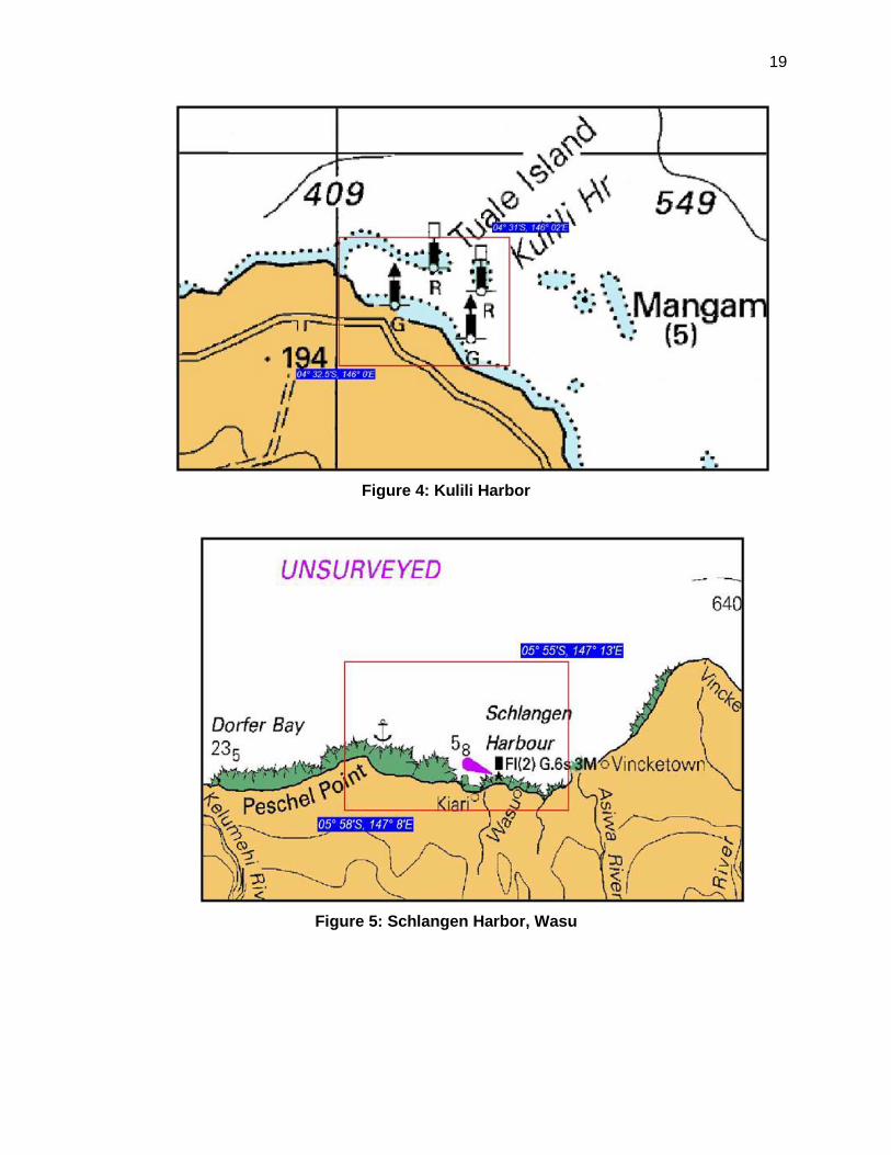
2 Schlangen Harbor, Wasu 05° 55.0’ 05° 58.0’ 147° 08.0’ 147° 13.0’ Aus 387
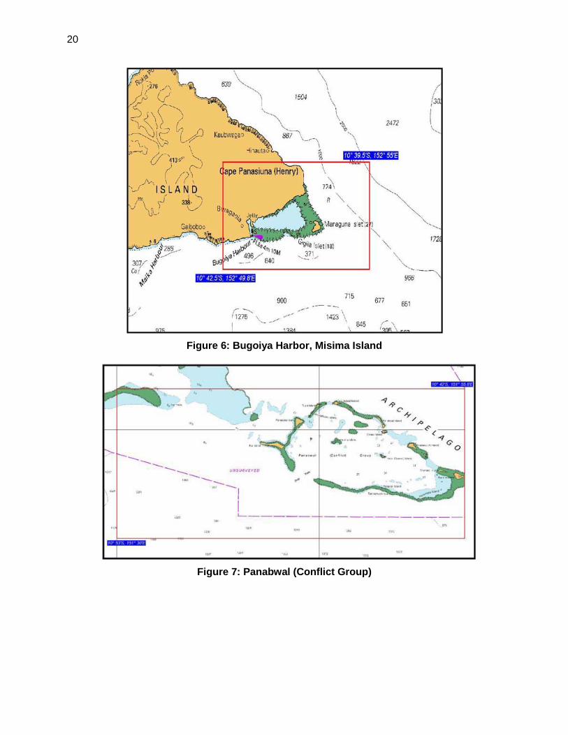
3 Bugoiya Harbor, Misima Island 10° 39.5’ 10° 42.5’ 152° 49.8’ 152° 55.0’ Aus 512
4 Panabwal (Conflict) Group 10° 42.0’ 10° 52.0’ 151° 38.0’ 151° 56.0’ Tourism Aus 509
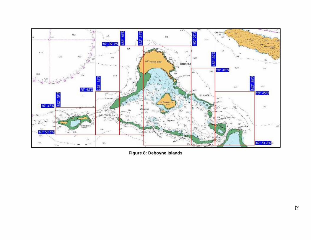
5 Deboyne Islands
10°47.0’ 10° 50.5’ 152°10.0’ 152°15.0’
Tourism Aus 512
10°45.0’ 10° 50.5’ 152°15.0’ 152°18.0’
10°39.2’ 10° 50.5’ 152°18.0’ 152°21.0’
10°39.2’ 10° 51.8’ 152°21.0’ 152°27.0’
10°42.0’ 10° 51.8’ 152°27.0’ 152°30.0’
10°45.0’ 10° 51.8’ 152°30.0’ 152°35.0’
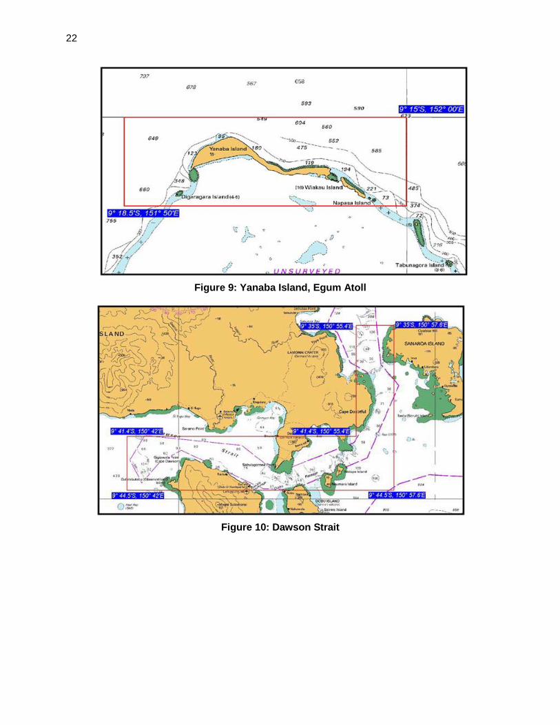
6 Yanaba Island, Egum Atoll 09° 15.0’ 09° 18.5’ 151° 50.0’ 152° 00.0’ Tourism Aus 515
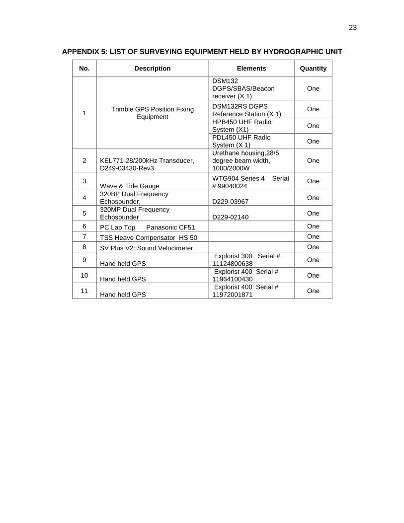
7 Dawson Strait 09° 35.0’ 09° 41.4’ 150° 55.4’ 150° 57.6’
Improved Shipping Aus 518
09° 41.4’ 09° 44.5’ 150° 42.0’ 150° 57.6’
19
Figure 4: Kulili Harbor
Figure 5: Schlangen Harbor, Wasu
20
Figure 6: Bugoiya Harbor, Misima Island
Figure 7: Panabwal (Conflict Group)
21
Figure 8: Deboyne Islands
22
Figure 9: Yanaba Island, Egum Atoll
Figure 10: Dawson Strait
23
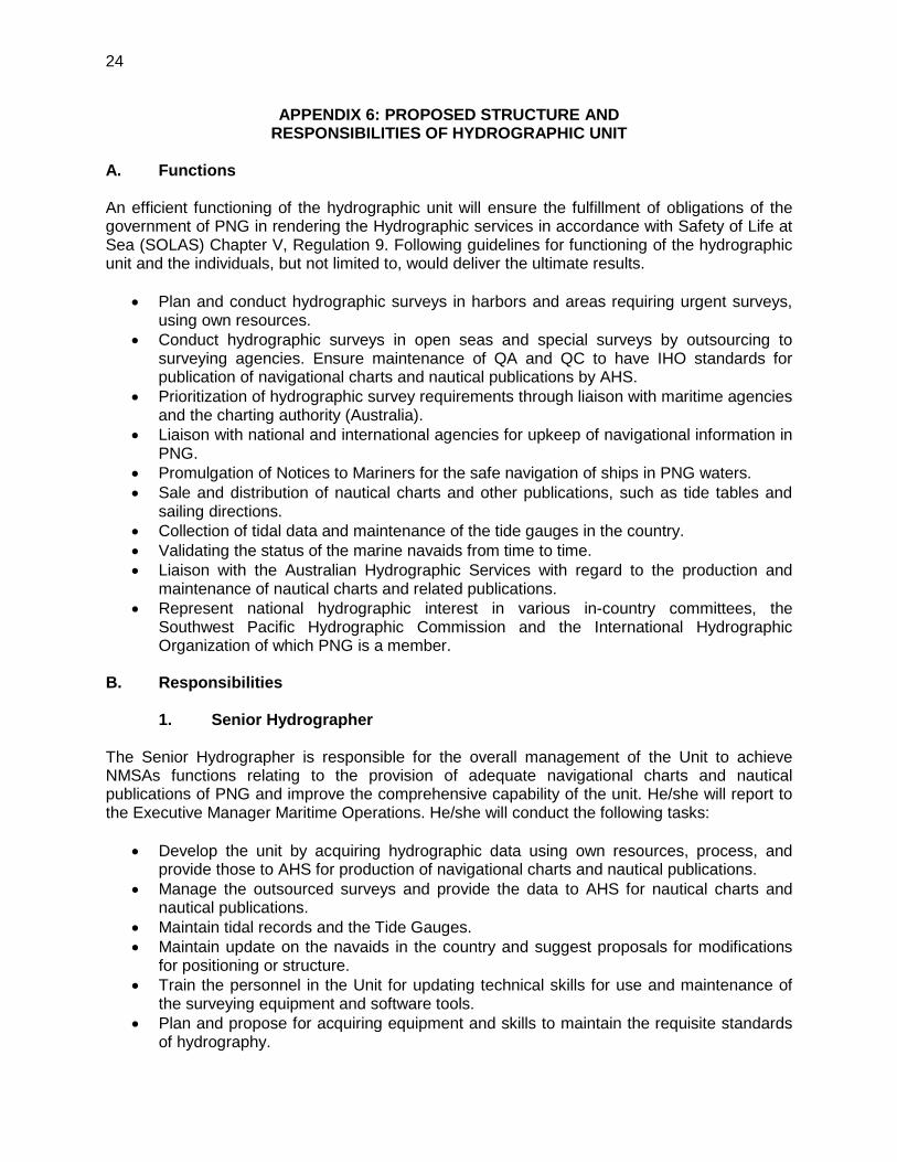
APPENDIX 5: LIST OF SURVEYING EQUIPMENT HELD BY HYDROGRAPHIC UNIT
No. Description Elements Quantity
1 Trimble GPS Position Fixing Equipment
DSM132 DGPS/SBAS/Beacon receiver (X 1)
One
DSM132RS DGPS Reference Station (X 1)
One
HPB450 UHF Radio System (X1) One
PDL450 UHF Radio System (X 1) One
2 KEL771-28/200kHz Transducer, D249-03430-Rev3
Urethane housing,28/5 degree beam width, 1000/2000W
One
3 Wave & Tide Gauge
WTG904 Series 4 Serial # 99040024
One
4 320BP Dual Frequency Echosounder, D229-03967 One
5 320MP Dual Frequency Echosounder D229-02140 One
6 PC Lap Top Panasonic CF51 One 7 TSS Heave Compensator HS 50 One 8 SV Plus V2: Sound Velocimeter One
9 Hand held GPS Explorist 300 Serial # 11124800638 One
10 Hand held GPS Explorist 400 Serial # 11964100430 One
11 Hand held GPS Explorist 400 Serial # 11972001871 One
24
APPENDIX 6: PROPOSED STRUCTURE AND RESPONSIBILITIES OF HYDROGRAPHIC UNIT
A. Functions An efficient functioning of the hydrographic unit will ensure the fulfillment of obligations of the government of PNG in rendering the Hydrographic services in accordance with Safety of Life at Sea (SOLAS) Chapter V, Regulation 9. Following guidelines for functioning of the hydrographic unit and the individuals, but not limited to, would deliver the ultimate results.
• Plan and conduct hydrographic surveys in harbors and areas requiring urgent surveys, using own resources.
• Conduct hydrographic surveys in open seas and special surveys by outsourcing to surveying agencies. Ensure maintenance of QA and QC to have IHO standards for publication of navigational charts and nautical publications by AHS.
• Prioritization of hydrographic survey requirements through liaison with maritime agencies and the charting authority (Australia).
• Liaison with national and international agencies for upkeep of navigational information in PNG.
• Promulgation of Notices to Mariners for the safe navigation of ships in PNG waters. • Sale and distribution of nautical charts and other publications, such as tide tables and
sailing directions. • Collection of tidal data and maintenance of the tide gauges in the country. • Validating the status of the marine navaids from time to time. • Liaison with the Australian Hydrographic Services with regard to the production and
maintenance of nautical charts and related publications. • Represent national hydrographic interest in various in-country committees, the
Southwest Pacific Hydrographic Commission and the International Hydrographic Organization of which PNG is a member.
B. Responsibilities
1. Senior Hydrographer The Senior Hydrographer is responsible for the overall management of the Unit to achieve NMSAs functions relating to the provision of adequate navigational charts and nautical publications of PNG and improve the comprehensive capability of the unit. He/she will report to the Executive Manager Maritime Operations. He/she will conduct the following tasks:
• Develop the unit by acquiring hydrographic data using own resources, process, and provide those to AHS for production of navigational charts and nautical publications.
• Manage the outsourced surveys and provide the data to AHS for nautical charts and nautical publications.
• Maintain tidal records and the Tide Gauges. • Maintain update on the navaids in the country and suggest proposals for modifications
for positioning or structure. • Train the personnel in the Unit for updating technical skills for use and maintenance of
the surveying equipment and software tools. • Plan and propose for acquiring equipment and skills to maintain the requisite standards
of hydrography.
25
• Maintain cooperation with the Australian Hydrographic Office in accordance with MoU between PNG and Australia for conduct of hydrographic surveys, production of charts and publications.
• Ensure availability of navigational charts and nautical publications of the area for sale and distribution.
2. Nautical Information Officer
The Nautical Information Officer is responsible for Hydrographic Surveys. He/she will report to the Senior Hydrographer. He/she will conduct the following tasks:
• Acquire hydrographic survey data and management of maritime safety information. • Assist the Senior Hydrographer in planning. • Coordinate activities with the hydrographic surveyors and conduct surveys. • Monitor the status of navigational aids. • Acquire tidal data from the ATG and maintenance of a data base for the same. • Maintain tide gauges.
3. Hydrographic Surveyors
The Hydrographic Surveyors are responsible for execution of surveying tasks and maintenance of equipment. He/she will report to the Nautical Information Officer. He/she will conduct the following tasks:
• Acquire hydrographic survey data using the survey equipment. • Assist Nautical Information Officer in post processing the survey data and preparing of
survey reports. • Operate and maintain surveying equipment.
4. GIS Officer
The Geographic Information System (GIS) Officer is responsible for GIS Data. He/she will report to the Senior Hydrographer. He/she will conduct the following tasks:
• Acquire and maintain GIS data. • Maintain data base for all land and hydrographic survey data. • Support to the hydrographic surveying teams by providing position fixing data from shore
stations. • Manage navigational chart maintenance process and all cartographic responsibilities as
required by the hydrographers • Ensure maintenance of requisite stocks of navigational charts and publications for sale. • Vet the data received from local and marine resources and forward to AHS for
publication in Notices to Mariners.
5. Data Acquisition Officer/Charting Officer The Data Acquisition Officer/Charting Officer is responsible for sale of nautical charts and publications. He/she will report to the GIS Officer for all duties appended below. Accounting issues, if any, is to be reported directly to the Senior Hydrographer. He/she will conduct the following tasks:
26
• Manage chart sales, distribution and general support services to the Hydrography Unit. • Sale and distribute navigational charts, tidal data and other related publications. • Maintain catalogue of charts and publication and ensure adequate supply to meet
customer needs. • Keep the navigational charts and nautical publications up to date with Notices to
Mariners. • Perform other administration tasks as required by the Senior Hydrographer or NMSA
management. • Attend to customers and process chart requests. • Account sale proceeds. • Order charts and processing of payments at accounts section for early settlement of bills
to AHS or the supply agencies of charts and publications.
27
APPENDIX 7: ESTIMATION OF TIME AND COST FOR HYDROGRAPHIC SURVEYS
Estimated Costing for Hydrographic Surveys
No. Harbors/ Passages
Ground control @ 2500 $/day
Bathymetry @ 83 $/l km
Side scan @ 400 $/ l
km
Bottom samplin
g @ 52.5 $/ station
Tidal stream
observations @ 1000 $ /
day
Coastlining @300 $/a team
of two/day
Fixing navaids
ashore/afloat and wrecks
@ 2500 $/day of 8
hours
Mobiliza tion @ 20%
Contingen cies - 5% Total cost ($)
1 Kulili Harbor 5,000 17,919 43,179 525 2,000 300 5,000 14,785 4,435 93,144
2 Schlangen Harbor, Wasu 5,000 87,529 210,914 2,678 2,000 675 5,000 62,759 18,828 395,383
3 Bugoiya Harbor, Misima Island 5,000 90,975 219,217 2,783 2,000 900 5,000 65,175 19,552 410,602
4 Panabwal (Conflict) Group 5,000 1,038,356 2,502,062 32,655 2,000 2,475 10,000 718,510 215,553 4,526,610
5 Deboyne Islands
0 102,118 246,068 3,150 2,000 4,950 10,000 73,657 22,097 464,041 0 97,302 234,462 2,993 0 0 0 66,951 20,085 421,792
5,000 199,915 481,723 6,143 0 0 0 138,556 41,567 872,903 0 439,997 1,060,235 13,703 0 0 0 302,787 90,836 1,907,557 0 173,377 417,776 5,303 0 0 0 119,291 35,787 751,534 0 198,405 478,084 6,143 0 0 0 136,526 40,958 860,116
6 Yanaba Island, Egum Atoll 5,000 202,620 488,240 6,353 2,000 1,950 7,500 142,732 42,820 899,214
7 Dawson Strait 10,000 83,820 201,977 2,520 2,000 5,250 5,000 62,114 18,634 391,315
0 279,160 672,675 8,768 2,000 0 7,500 194,020 58,206 1,222,329
Total Estimated cost 40,000 3,011,494 7,256,611 93,713 16,000 16,500 55,000 1,573,398 629,359 13,216,539
28
Single Beam Echosounding
No. Harbors/Passages
Survey area
Length (E-W) nm
Survey area
Breadth (N-S)
scale of
survey 1:
Speed of
boat knots
spacing of
sounding lines in
m
No. of sounding
lines running North-South
No. of sounding
lines East-West
Turn around
distance in km
Check line
sounding in km
Total sounding
line kilometers
(lKm)
Total hours for
single beam echo
sounding
No days for
sounding @8 hrs
per day/boat
1 Kulili Harbor 1.5 2 10,000 6 50 56 74 2.7 5.6 216 19 2
2 Schlangen Harbor, Wasu 3 5 10,000 6 50 112 186 5.5 11.2 1,055 94 11
3 Bugoiya Harbor, Misima Island 3 5.2 10,000 6 50 112 193 5.5 11.2 1,096 98 12
4 Panabwal (Conflict) Group 10 18 10,000 6 50 372 670 18.6 37.2 12,510 1,121 140
5 Deboyne Islands
3.5 5 10,000 6 50 130 186 6.5 13.0 1,230 110 13 5.5 3 10,000 6 50 205 112 10.2 20.5 1,172 105 13
11.3 3 10,000 6 50 420 112 21.0 42.0 2,409 216 26 12.6 6 10,000 6 50 469 223 23.4 46.9 5,301 475 59 9.8 3 10,000 6 50 365 112 18.2 36.5 2,089 187 23 6.8 5 10,000 6 50 253 186 12.6 25.3 2,390 214 26
6 Yanaba Island, Egum Atoll 3.5 10 10,000 6 50 130 372 6.5 13.0 2,441 219 27
7 Dawson Strait 6.4 2.2 10,000 6 50 238 82 11.9 23.8 1,010 90 11 3.1 15.6 10,000 6 50 115 580 5.7 11.5 3,363 301 37
29
Computation of Time for Data Acquisition
Number of days for
No. Harbors/Passages Groun
d control
Bathymetry @ 8 hrs /
day
Side Scan Sonar @8 hrs / day
Bottom sampling @ 15
samples per 8
hours / day
Tidal Stream
observation (need to be done during spring tides)
Tidal obser-vation (on
all days when
bathymetry is done)
Coastlining @ 4 km/day
Fixing of
navaids
Wreck investigatio
n
Total Data acquisition
1 Kulili Harbor 2 2 1 1 2 2 1 1 1 11
2 Schlangen Harbor, Wasu 2 11 6 3 2 11 2 1 1 28
3 Bugoiya Harbor, Misima Island 2 12 6 4 2 12 3 1 1 31
4 Panabwal (Conflict) Group 2 140 70 41 2 140 8 3 1 268
5 Deboyne Islands
13 7 4 2 13 17 3 1 46 13 7 4 13 23
2 26 13 8 26 49 59 30 17 59 106 23 12 7 23 41 26 13 8 26 47
6 Yanaba Island, Egum Atoll 2 27 14 8 2 27 7 2 1 62
7 Dawson Strait
4 11 6 3 2 11 18 1 1 45 37 19 11 2 37 0 2 1 72
Total number of days 828