Embed Size (px)
Citation preview
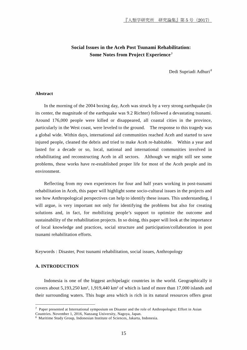
『人類学研究所 研究論集』第 5 号(2017)
15
Social Issues in the Aceh Post Tsunami Rehabilitation: Some Notes from Project Experience7
Dedi Supriadi Adhuri 8
Abstract
In the morning of the 2004 boxing day, Aceh was struck by a very strong earthquake (in its center, the magnitude of the earthquake was 9.2 Richter) followed a devastating tsunami. Around 176,000 people were killed or disappeared, all coastal cities in the province, particularly in the West coast, were leveled to the ground. The response to this tragedy was a global wide. Within days, international aid communities reached Aceh and started to save injured people, cleaned the debris and tried to make Aceh re-habitable. Within a year and lasted for a decade or so, local, national and international communities involved in rehabilitating and reconstructing Aceh in all sectors. Although we might still see some problems, these works have re-established proper life for most of the Aceh people and its environment.
Reflecting from my own experiences for four and half years working in post-tsunami rehabilitation in Aceh, this paper will highlight some socio-cultural issues in the projects and see how Anthropological perspectives can help to identify these issues. This understanding, I will argue, is very important not only for identifying the problems but also for creating solutions and, in fact, for mobilizing people’s support to optimize the outcome and sustainability of the rehabilitation projects. In so doing, this paper will look at the importance of local knowledge and practices, social structure and participation/collaboration in post tsunami rehabilitation efforts.
Keywords : Disaster, Post tsunami rehabilitation, social issues, Anthropology A. INTRODUCTION
Indonesia is one of the biggest archipelagic countries in the world. Geographically it
covers about 5,193,250 km², 1,919,440 km² of which is land of more than 17,000 islands and their surrounding waters. This huge area which is rich in its natural resources offers great
7 Paper presented at International symposium on Disaster and the role of Anthropologist: Effort in Asian Countries. November 1, 2016, Nanzang University, Nagoya, Japan. 8 Maritime Study Group, Indonesian Institute of Sciences, Jakarta, Indonesia.
Research Paper of the Anthropological Institute Vol.5 (2017)
16
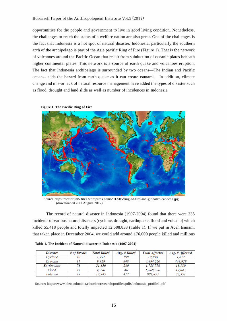
opportunities for the people and government to live in good living condition. Nonetheless, the challenges to reach the status of a welfare nation are also great. One of the challenges is the fact that Indonesia is a hot spot of natural disaster. Indonesia, particularly the southern arch of the archipelago is part of the Asia pacific Ring of Fire (Figure 1). That is the network of volcanoes around the Pacific Ocean that result from subduction of oceanic plates beneath higher continental plates. This network is a source of earth quake and volcanoes eruption. The fact that Indonesia archipelago is surrounded by two oceans—The Indian and Pacific oceans- adds the hazard from earth quake as it can create tsunami. In addition, climate change and mis-or lack of natural resource management have added the types of disaster such as flood, drought and land slide as well as number of incidences in Indonesia
The record of natural disaster in Indonesia (1907-2004) found that there were 235 incidents of various natural disasters (cyclone, drought, earthquake, flood and volcano) which killed 55,418 people and totally impacted 12,688,833 (Table 1). If we put in Aceh tsunami that taken place in December 2004, we could add around 176,000 people killed and millions
Figure 1. The Pacific Ring of Fire
Source:https://ecsforum5.files.wordpress.com/2013/05/ring-of-fire-and-globalvolcanoes1.jpg
(downloaded 28th August 2017)
Table 1. The Incident of Natural disaster in Indonesia (1907-2004)
Source: https://www.ldeo.columbia.edu/chrr/research/profiles/pdfs/indonesia_profile1.pdf
『人類学研究所 研究論集』第 5 号(2017)
17
more impacted 9. These are huge number of people, and we should also remember that these disasters can produce long term impacts to the environment and the people.
As our earth is getting old and our pressure on her intensified, some are carried out badly, it should be no surprise to see the increasing trend of disaster. This is happening in many places including Indonesia. A week before my travel to this seminar (1 November 2016), a day long heavy rain had caused serious flood and land slide in Garut, West Jawa. This incident had killed 20 people, 14 people were missing, possibly dead. Similar incident also took place in many other parts of the country and this happens almost every rainy season.
With the above challenges, Indonesia needs to improve her efforts in disaster management which includes disaster mitigation, preparedness, emergency handling and post disaster reconstruction. This paper is an attempt to share some experiences in post disaster rehabilitation. Reflecting from my own experiences for four and half years working in Aceh, this paper will highlight some socio-cultural issues in the projects and see how Anthropological perspectives can help to identify these issues. This understanding, I will argue, is very important not only for identifying the problems but also for creating solutions and, in fact, for mobilizing people’s support to optimize the outcome and sustainability of the rehabilitation projects. In so doing, this paper will look at the importance of local knowledge and practices, social structure and participation/collaboration in post tsunami rehabilitation efforts.
B. THE PROJECTS The Framework
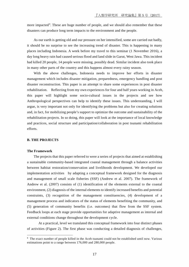
The projects that this paper referred to were a series of projects that aimed at establishing a sustainable community-based integrated coastal management through a balance activities between habitat restoration/conservation and livelihoods development. We developed our implementation activities by adapting a conceptual framework designed for the diagnosis and management of small scale fisheries (SSF) (Andrew et al. 2007). The framework of Andrew et al. (2007) consists of (1) identification of the elements external to the coastal environment, (2) diagnosis of the internal elements to identify increased benefits and potential constraints, (3) recognition of the management constituencies, (4) development of a management process and indicators of the status of elements benefiting the community, and (5) generation of community benefits (i.e. outcomes) that flow from the SSF system. Feedback loops at each stage provide opportunities for adaptive management as internal and external conditions change throughout the development cycle.
At a practical, level we translated this conceptual framework into four distinct phases of activities (Figure 2). The first phase was conducting a detailed diagnosis of challenges,
9 The exact number of people killed in the Aceh tsunami could not be established until now. Various estimations point to a range between 176,000 and 280,000 people.
Research Paper of the Anthropological Institute Vol.5 (2017)
18
opportunities and management options in the context of post-tsunami rehabilitation. In this regard, we conducted several survey and participatory analysis of the dynamics of the socio-ecological systems (SES) before and after the tsunami. The information collected in the first phase was used to feed the work of the second phase that was establishing the management plan. The management planning process addressed outcomes desired (SES configuration), actions needed (tested responses or management options) to achieve the outcomes and indicators to evaluate success of the actions. Phase three was testing the management options/intervention which covered habitat restoration, livelihood rehabilitation and management arrangement that were environmentally sustainable and socio-economically viable. It should be noted that we carried out all these phases with participatory method involving relevant stakeholders (community, local government offices and various NGOs working in the site). Community participations were increased as the phases moved along. We developed this strategy as part of the exit strategy with the expectation that as the project ended, the community could carry on the management activities independently.
Figure 2. Project Implementation Activities/Strategy
Testing & adoption of management plan
Fisheries Aquaculture feasibility
Habitat restoration
Socioeconomic
Institutions
Surveys/Mapping:
FGD
Workshop
Key Informant
Stakeholder Consultations:
Diagnosis
Setting of Indicators (resource condition & community
needs)
&
Coastal Management Planning
Phase I
Phase II
Phase III
Output (sustainable livelihoods, food, income, education)
Phase IV
(feedback)
Source: Fieldwork
『人類学研究所 研究論集』第 5 号(2017)
19
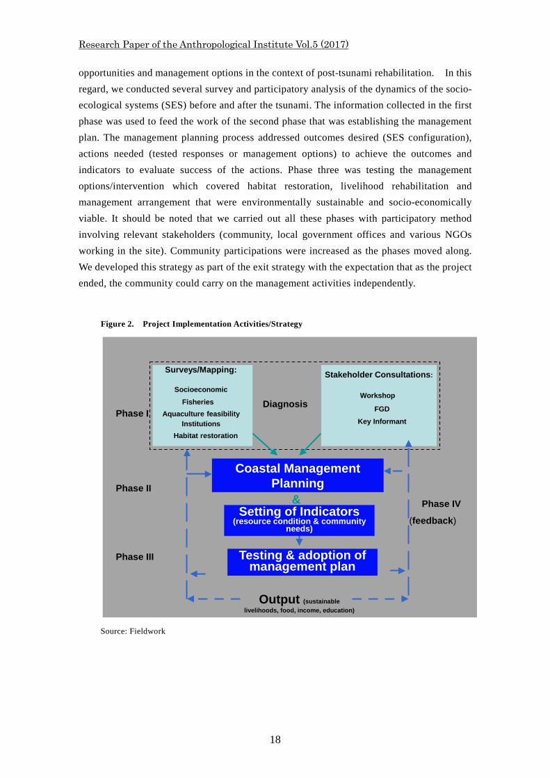
The Site These projects were implemented in four coastal villages of Sampointet sub-district,
Aceh Jaya. These villages were Pulau Raya, Lhok Kruet, Menasah Kulam and Blang Monlung villages. These villages located about 80-90 km to the East of Banda Aceh, the capital city of the province (Figure 3). During the project implementation period (2006-2010) it took about four to five hours driving, about half of the route, the condition of road was still damaged or being repaired.
Geographically, three villages are located close between each other (Figure 3). Lhok Kruet and Meunasah Kulam are situated in the Lhok Kruet embayment. Blang Monlung located further inland but connected by a road and a river to Meunasah Kulam and Lhok Kruet. Pulo Raya is a village on the island that bears the same name. The island of Pulo Raya is located around 500 meter to the west off Lhok Kruet village. The total area of these villages is around 4699 Ha, consisting of settlement and other buildings (264 Ha), agricultural land (845 Ha), plantation (215 Ha), forest (700 Ha), and others (including inter tidal and swamp area) 2676 (Ha). (Table 2)
Figure 3. Site Location
Source: Fieldwork and Google-earth
Research Paper of the Anthropological Institute Vol.5 (2017)
20
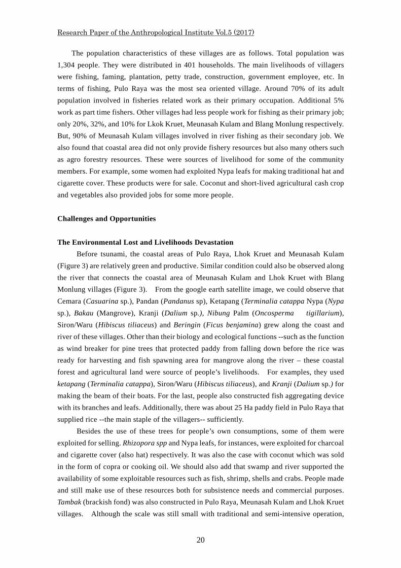
The population characteristics of these villages are as follows. Total population was 1,304 people. They were distributed in 401 households. The main livelihoods of villagers were fishing, faming, plantation, petty trade, construction, government employee, etc. In terms of fishing, Pulo Raya was the most sea oriented village. Around 70% of its adult population involved in fisheries related work as their primary occupation. Additional 5% work as part time fishers. Other villages had less people work for fishing as their primary job; only 20%, 32%, and 10% for Lkok Kruet, Meunasah Kulam and Blang Monlung respectively. But, 90% of Meunasah Kulam villages involved in river fishing as their secondary job. We also found that coastal area did not only provide fishery resources but also many others such as agro forestry resources. These were sources of livelihood for some of the community members. For example, some women had exploited Nypa leafs for making traditional hat and cigarette cover. These products were for sale. Coconut and short-lived agricultural cash crop and vegetables also provided jobs for some more people. Challenges and Opportunities The Environmental Lost and Livelihoods Devastation
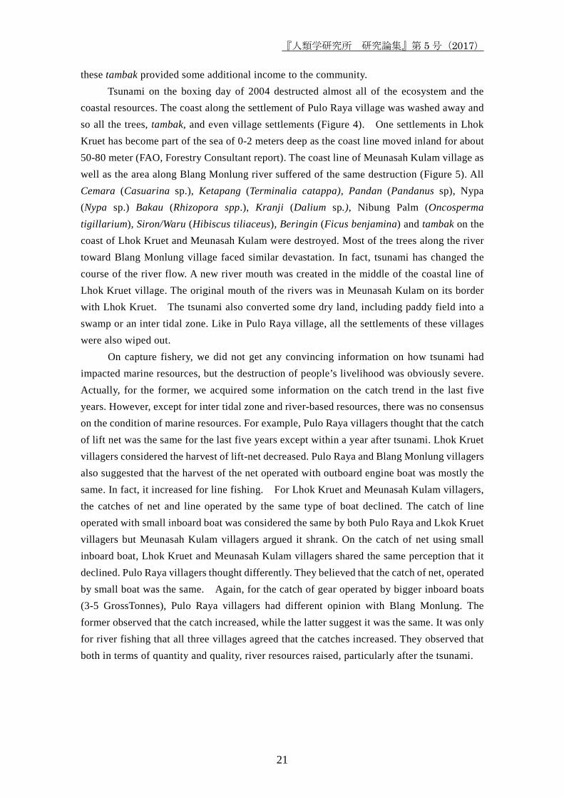
Before tsunami, the coastal areas of Pulo Raya, Lhok Kruet and Meunasah Kulam (Figure 3) are relatively green and productive. Similar condition could also be observed along the river that connects the coastal area of Meunasah Kulam and Lhok Kruet with Blang Monlung villages (Figure 3). From the google earth satellite image, we could observe that Cemara (Casuarina sp.), Pandan (Pandanus sp), Ketapang (Terminalia catappa Nypa (Nypa sp.), Bakau (Mangrove), Kranji (Dalium sp.), Nibung Palm (Oncosperma tigillarium), Siron/Waru (Hibiscus tiliaceus) and Beringin (Ficus benjamina) grew along the coast and river of these villages. Other than their biology and ecological functions --such as the function as wind breaker for pine trees that protected paddy from falling down before the rice was ready for harvesting and fish spawning area for mangrove along the river – these coastal forest and agricultural land were source of people’s livelihoods. For examples, they used ketapang (Terminalia catappa), Siron/Waru (Hibiscus tiliaceus), and Kranji (Dalium sp.) for making the beam of their boats. For the last, people also constructed fish aggregating device with its branches and leafs. Additionally, there was about 25 Ha paddy field in Pulo Raya that supplied rice --the main staple of the villagers-- sufficiently.
Besides the use of these trees for people’s own consumptions, some of them were exploited for selling. Rhizopora spp and Nypa leafs, for instances, were exploited for charcoal and cigarette cover (also hat) respectively. It was also the case with coconut which was sold in the form of copra or cooking oil. We should also add that swamp and river supported the availability of some exploitable resources such as fish, shrimp, shells and crabs. People made and still make use of these resources both for subsistence needs and commercial purposes. Tambak (brackish fond) was also constructed in Pulo Raya, Meunasah Kulam and Lhok Kruet villages. Although the scale was still small with traditional and semi-intensive operation,
『人類学研究所 研究論集』第 5 号(2017)
21
these tambak provided some additional income to the community. Tsunami on the boxing day of 2004 destructed almost all of the ecosystem and the
coastal resources. The coast along the settlement of Pulo Raya village was washed away and so all the trees, tambak, and even village settlements (Figure 4). One settlements in Lhok Kruet has become part of the sea of 0-2 meters deep as the coast line moved inland for about 50-80 meter (FAO, Forestry Consultant report). The coast line of Meunasah Kulam village as well as the area along Blang Monlung river suffered of the same destruction (Figure 5). All Cemara (Casuarina sp.), Ketapang (Terminalia catappa), Pandan (Pandanus sp), Nypa (Nypa sp.) Bakau (Rhizopora spp.), Kranji (Dalium sp.), Nibung Palm (Oncosperma tigillarium), Siron/Waru (Hibiscus tiliaceus), Beringin (Ficus benjamina) and tambak on the coast of Lhok Kruet and Meunasah Kulam were destroyed. Most of the trees along the river toward Blang Monlung village faced similar devastation. In fact, tsunami has changed the course of the river flow. A new river mouth was created in the middle of the coastal line of Lhok Kruet village. The original mouth of the rivers was in Meunasah Kulam on its border with Lhok Kruet. The tsunami also converted some dry land, including paddy field into a swamp or an inter tidal zone. Like in Pulo Raya village, all the settlements of these villages were also wiped out.
On capture fishery, we did not get any convincing information on how tsunami had impacted marine resources, but the destruction of people’s livelihood was obviously severe. Actually, for the former, we acquired some information on the catch trend in the last five years. However, except for inter tidal zone and river-based resources, there was no consensus on the condition of marine resources. For example, Pulo Raya villagers thought that the catch of lift net was the same for the last five years except within a year after tsunami. Lhok Kruet villagers considered the harvest of lift-net decreased. Pulo Raya and Blang Monlung villagers also suggested that the harvest of the net operated with outboard engine boat was mostly the same. In fact, it increased for line fishing. For Lhok Kruet and Meunasah Kulam villagers, the catches of net and line operated by the same type of boat declined. The catch of line operated with small inboard boat was considered the same by both Pulo Raya and Lkok Kruet villagers but Meunasah Kulam villagers argued it shrank. On the catch of net using small inboard boat, Lhok Kruet and Meunasah Kulam villagers shared the same perception that it declined. Pulo Raya villagers thought differently. They believed that the catch of net, operated by small boat was the same. Again, for the catch of gear operated by bigger inboard boats (3-5 GrossTonnes), Pulo Raya villagers had different opinion with Blang Monlung. The former observed that the catch increased, while the latter suggest it was the same. It was only for river fishing that all three villages agreed that the catches increased. They observed that both in terms of quantity and quality, river resources raised, particularly after the tsunami.
Research Paper of the Anthropological Institute Vol.5 (2017)
22
People’s different opinions on understanding the resources was not only about the catch rate but also their explanation on why and consequences of the changes. For example, Pulo Raya villagers believed that the natural changes, in this regard it referred to the logs that were brought by the tsunami to the bottom of the sea had added new shelters to fish which, then, increased the catch of line fishing. To the contrary, for Lhok Kruet villagers, it was the natural change that caused the decline of the catch of the same fishing technology.
The destruction of the fishing vessels was very obvious. People reported that the lost of all type of boats were more than 80%. In fact, Meunasah Kulam and Blang Monlung lost their entire fishing boats. Pulo Raya also suffered the same for most type of their boats. Only lift net that 17% was still intact, other type of boats were destroyed or missing.
Similar level of devastation of fishing gear was apparent. The destruction of jermal, that is the net used in lift net operation, was obviously the same as the destruction level of the fishing vessel since the nets were attached to the gear. Various nets (gill net, trammel net,
Before After
Before After
『人類学研究所 研究論集』第 5 号(2017)
23
cast net, etc.) fishing line, crab-trap, etc would be similar, since most, if not all, of them were stored on the boats, coastal areas or home which all were totally or, at least heavily damaged.
The damage to the fisheries infrastructure was also serious. A dock, fish auction place and some constructions used for post-harvest processing were totally destroyed. Adding to this was the breakdown of road which was very important for the distribution of ice to fishers and the marketing of the catch out of the village.
For the people, these destructions were not only a lost of natural resources and environment but also the lost of associated livelihoods. More than hundreds households whose their economy depended on capture fishing; whether they were fishers, post-harvest processors, or fish traders, were in peril. For fishers, having no fishing vessel or gear meant no fishing. Then, there would be no fish to sell or to process for fish seller and post-harvest worker. Traditional hat, roof and cigarette cover productions, the activities that provided additional income for women, had gone since Nypa was cleared by the tsunami. Tambak farmers were, of course, had nothing to work for as their tambak was totally destroyed. Additionally, agricultural activities associated with cash crops ceased as paddy field, and other dry lands were converted into inter tidal zone or swamp.
Nonetheless, the conversion of dry land into aquatic zone had opened the possibility for aquaculture development. Thus, if before tsunami the most possible tambak construction was only along the river, more area was now suitable for aqua-culture development. The development of aquaculture would yield at least two benefits. First, it would generate new sources of income and protein. Second, it might reduce the pressure on marine resources. This was because the development of aquaculture might prevent the involvement of more people in capture fisheries in which the resources were indicated to have been in the status of heavily exploited if not over exploited already. The development of aquaculture might even attract capture fishers to leave their fishing activities.
In this regard, the challenge for creating the management plan was how to accommodate the needs of environmental and livelihood rehabilitations. This challenge was huge not only because the devastation of both environment and people’s livelihood were serious but it was also due to the fact that the environmental rehabilitation was not always in line with livelihoods development. In fact, they could be contradictory because environmental rehabilitation was strongly associated with conservation or environmental protection, while livelihood development concerned more on making use of or exploiting the environment. This was particularly true in reference to Aceh. The development of brackish fish pond (tambak) was considered as a main cause of mangrove deforestation (Meldrilzam et al. 2005; Kanagaratnam at. al. 2006; Griffin C, D. Ellis, S. Beavis, D. Zoleta-Nantes 2013).
In this circumstance, it was impossible to develop any plan that could maximize its value to the environmental protection as well as livelihood development. There should be some negotiations that facilitate the compromise of the achievement of environmental and livelihood development goals. On the conceptual level, this could be calculated. The implementation on the ground, however, was not easy. There was segregation between
Research Paper of the Anthropological Institute Vol.5 (2017)
24
agencies or departments that worked for environmental issues and livelihood developments. With this, there was a tendency that a particular institution created and implemented development program that did not really take into account the interest of other sector. This created problem with other institution that had different plan in the same location. The problem became more complicated if community had different interest and priorities. The following section will, among others, discuss an example of this complication.
C. THE SOCIAL ISSUES Rehabilitation: ‘Competitive Humanitarianism’ or Coordinative Support?
The site of our project, the four villages in Sampoinet, received support from several institutions. Government agencies such as Rehabilitation and Reconstruction Agency (BRR) for Aceh and Nias, UN organizations, international, national and local NGOs and local communities have involved in various rehabilitation programs in the four villages. These programs ranging from distributing basic needs up until the construction of houses, sanitation and other infrastructures. While the former were part of emergency relief programs, the latter were more for long term development goals. In coastal and fisheries sectors, these includes greenbelt project, aqua culture (brackish fish fond and fish cage), boat and fishing gear distributions, post harvest related aid, and the construction of a new fish auction place. Looking at the variety of these programs, they clearly covered most aspects of coastal and fisheries rehabilitation. With these, it should have been logical if we expected that recovery of coastal and fishery sector would be fast. Nonetheless, there was a ‘competitive humanitarianism’ (Stirrat, 2006) that had constrained coordination between institutions involved in rehabilitation programs. In fact, conflicts broke out as the product of conflicting interest and implementations of these projects. The following was a rather detailed account of these conflicts.
In early 2006, FAO Forestry Division developed an Integrated Coastal Management Programme, focused more on the plan of establishing coastal greenbelt. In March-April of the same year, they sent a mangrove expert to access the condition of the coastal area and to calculate the need for coastal replanting. Participatory rural appraisal (PRA) training and field appraisal assistance were also conducted in Lhok Kruet around the same time. Representatives from Pulo Raya, Lhok Kruet, Meunasah Kulam, Crak Mong and Krueng No participated in the PRA since the establishment of the greenbelt covered the coastal area of these villages. The objectives of the PRA were two. The first was for socialization of FAO forestry programme to the potential beneficiaries and local stakeholders, second was for initial activities in selecting potential local trainer and facilitator for village appraisal and start building local potential leaders for implementing future programme and activities and a follow up planning after the village appraisal.
Although there were some concerns form PRA participants that the communities were
『人類学研究所 研究論集』第 5 号(2017)
25
actually more interested in livelihood related program rather than conservation focused activities, there was not strong resistance from the community toward the FAO’s plan. 10 FAO forestry division pursued the plan by bringing the seeds of various trees (coconut, mangrove, etc.) to the temporary nursery area closer to these villages.
FAO was almost ready to implement their plan when BRR came to these villages implementing a tambak (re-)construction project. A backhoe was brought and started digging the land for fish pond on the same area where FAO had planned to establish the greenbelt. Conflict was inevitable. FAO protested BRR. Some negotiations took place, but all were dead lock. One unresolved problem was that, the work of FAO should always in accordance with formal regulation, one if which stipulated that 200 meter from coast line should be allocated for greenbelt. The area of tambak construction was within the limit of greenbelt allocated zone. Thus, for FAO, unless there were some changes in the regulation, they could not do any support for non greenbelt related activities in the area. For BRR, there was no point of return, the proposal was approved and the money was granted. Cancellation of the work, by the Indonesian government standard, would be considered as the fail of executing the granted work. This would influence the flow of future grant. Additionally, abortive termination of tambak project would also upset community ‘tambak group’ who were the beneficiaries of BRR project. Finding no possible compromise, FAO put off the plan, except in a village where BRR tambak project did not cover. BRR tambak construction was pursued. 11
The syndrome of ‘competitive humanitarian’ was also apparent in the rehabilitation of capture fishing. In the early stage of rehabilitation process, there was a rush of aid distribution. This was basically because donors were very keen to help local community to rebuilt their livelihood. NGOs and other institutions involved in ‘competitive humanitarian’ raced for showing off that they were among the first agencies helping local people. In Stirrat’s words, it is said:
‘From the beginning the pressure was on the agencies not only to e effective but to be seen to be effective. They had to try to justify the vast investment that millions of stakeholders had made in the relief effort. And they had to intervene in ways which these ‘stakeholders’ would recognize as being ‘relief.’ So from the beginning there was a certain bias in the sorts of interventions favored by the relief agencies towards those which were highly visible, photogenic, and focus on the
10 One of the reasons, as it is stated in the appraisal report, was that the community would consider the project from the short term gain that was taking the labour money from the planting activities (cash for work) (Ibid. 12). 11 Ironically, there were some technical and managerial problems in the implementation of the BRR project. The field coordinator of the project was one of local village head who had limited experience on tambak. This, among other, resulted the physical construction of tambak was not done properly. Only one or two plots, around 2-3 Ha, out of 45 Ha of construction, was ready for operation when the time limit of the project ended.
Research Paper of the Anthropological Institute Vol.5 (2017)
26
poor ....’ (2006, 12. italic is in the original)
This tendency creates so many problems. In fishery, these include 'improper construction and the distribution of unsuitable boat type, un-even distribution, wrong target group, etc. (Janssen 2005). In the short run, this ineffectiveness resulted the waste of a huge amount of money and the delay of fisheries rehabilitation since many of distributed aid were unusable or incomplete. It also created conflicts between actors at various levels. In the long run, even those useable boats and gear might create problems to the community and fisheries resources since they were mostly small size vessels operating on limited inshore area (Tewfik, A et. al 2010).
Nonetheless, at the later stage of the rehabilitation some coordination efforts were initiated. Facilitated by a UN agency, sub-district government office took charge as coordination point at local level. Monthly meeting was organized to evaluate the development of all the programs in the districts. Problems were identified and solutions were discussed. Some agencies were also aware that they could not work alone, so they looked for partner or welcome the invitation for collaboration. For example, the Australian Indonesia Partnership for Reconstruction and Development (AIPRD) which run a project on Local Governance and Infrastructure for Communities in Aceh (LOGICA) project, was happy when we approached them for a collaboration. This was because their project prepared a general village development plan; they believed that our project aiming at creating an integrated coastal management plan would complement their work. Caritas Czech, an International NGO who run some fishery livelihood development projects out side our village sites, would also support us by bringing their resources to the villages to involve in the implementation of, at least, partly our management plan.
These examples showed that at a particular time the presence of so many supporting agencies could create so many problems since they have different interest, priorities, culture, etc. But, their presence could open new options for a better result of the programs. Certainly, these agencies brought funds, expertise and other sources that would be complementary. The challenge was how to create a good coordination and collaboration. It was difficult but possible.
Community Strengths and Weakness Community-base management: The Panglima Laot
Although there was a fear that even before tsunami, marine resources in Aceh had been heavily or even over exploited (Abu Thalib, Isa, Ismail, & Yusof 2004), from the beginning of the rehabilitation process up until currently, the focus of fisheries projects were on livelihood development with little, for not saying not at all, attention given to the management aspect. Additionally, although rural appraisals were carried out, the projects were mostly took the form of top down; the intervention programs were decided on the project plan. As noted
『人類学研究所 研究論集』第 5 号(2017)
27
earlier, this often created problems. Since our project was implemented as a collaborative work, by which community was
an important element, the project could identified the presence of a traditional marine resource management practice, locally called The Panglima Laot (lit. The Sea commander). The following is the general characteristics of the Panglima Laot in Lhok Ktuet:
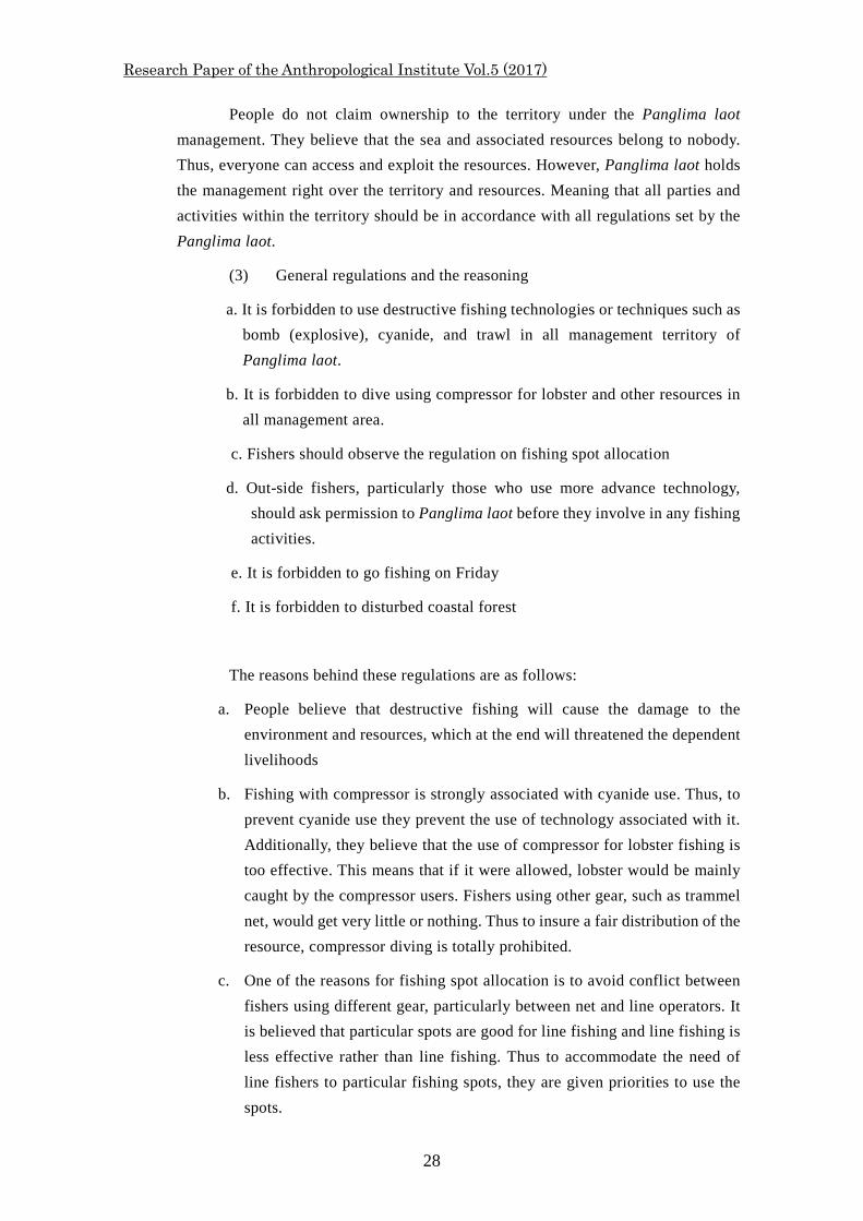
(1) Institutional arrangement. Panglima laot is the organization as well as the name of its leader that manages the sea territory and fishing activities, and coastal management in general. The organization consists of some advisors, the Panglima laot and vice Panglima laot, Secretary, Treasurer and Panglima Teupin (Figure 6). Advisors function as the supervisors for the Panglima laot. Normatively, supervisors monitor and evaluate as well as support Panglima laot in his works. Advisors consist of sub-district head and traditional leaders in the communities. Panglima laot and vice Panglima laot are in charge for the daily management of the fisheries and the coast, supported by other functionaries such as a Secretary and a Treasurer. In communication with fishers, Panglima laot is also assisted by a fishers’s leader in each village, called Panglima Teupin.
According to some informants, before tsunami one of the main characteristics of this institution was the spirit of togetherness. This was not only indicated by the appointment of all functionaries though an election, but also by the decision making process in the daily management practice. They said that the decision of all important matters usually made though a meeting of all the functionaries of the Panglima laot and some other relevant parties. For example, if there was a serious conflict between outside and local fishers, a meeting would be organized to solve the problem attended by all Panglima laot functionaries and the conflicting parties.
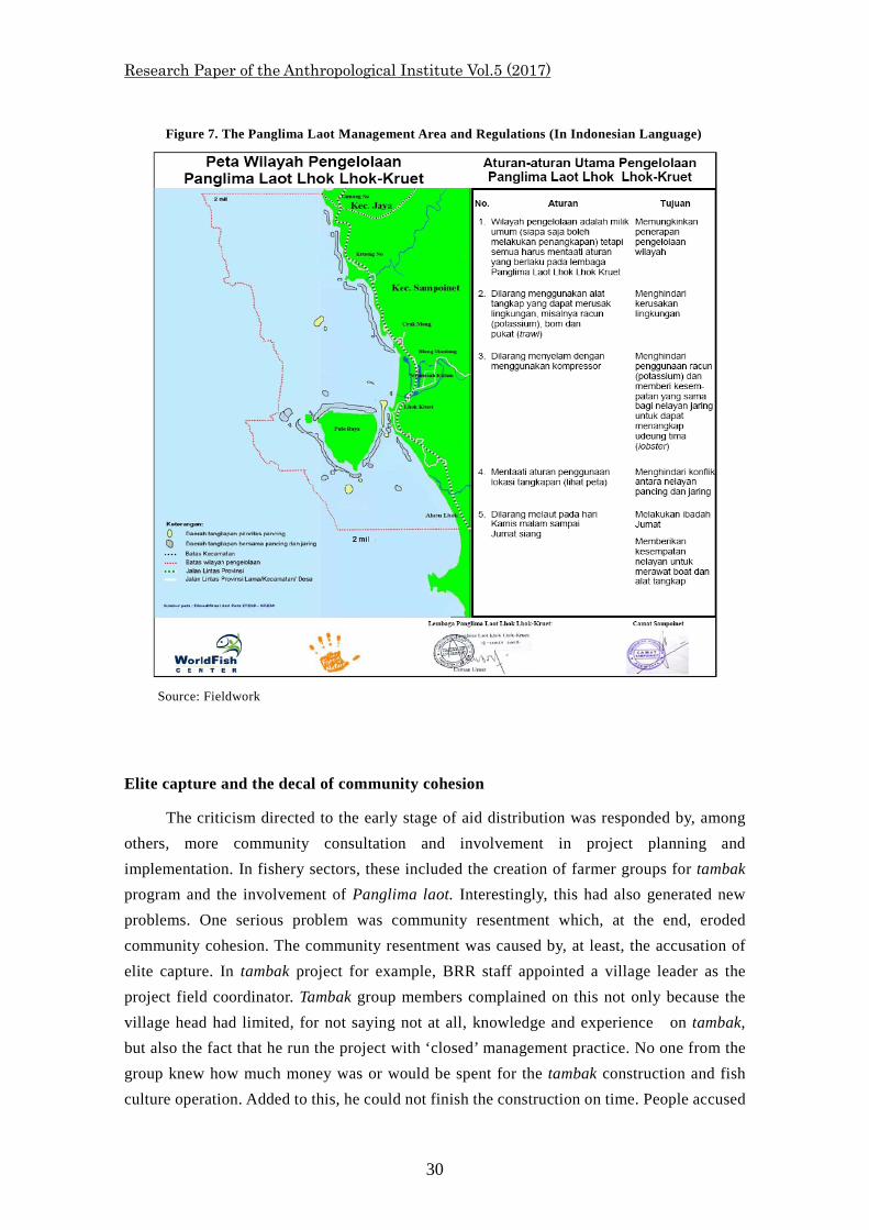
(2) The territory and its tenure. The sea territory under the Panglima laot Lhok Kruet management covers an area from the boundary of Sampoinet with Jaya sub-districts on the North end to a point called Aloe Lhok to the South (Figure 7) and the water surrounding Pulo Raya village. Toward the sea, it goes up to two miles 12 from the coastline. The whole management area of Panglima Laut Lhok Kruet covers the waters of five villages (Pulo raya, Lhok Kruet, Meunasah Kulam, Crak Mong and Krueng No).
Within the management territory, people identify and name main fishing spots. The naming seems to follow the association of a particular spot with a land mark on the inland area, the association between the spot with the ‘founder,’ and resources, or the special function of the spot. There are some regulations on the allocation of these fishing spots to particular fishing gear (Figure 7).
12 The two miles is calculated as the length of two traditional nets (jaring darat)
Research Paper of the Anthropological Institute Vol.5 (2017)
28
People do not claim ownership to the territory under the Panglima laot management. They believe that the sea and associated resources belong to nobody. Thus, everyone can access and exploit the resources. However, Panglima laot holds the management right over the territory and resources. Meaning that all parties and activities within the territory should be in accordance with all regulations set by the Panglima laot.
(3) General regulations and the reasoning
a. It is forbidden to use destructive fishing technologies or techniques such as bomb (explosive), cyanide, and trawl in all management territory of Panglima laot.
b. It is forbidden to dive using compressor for lobster and other resources in all management area.
c. Fishers should observe the regulation on fishing spot allocation
d. Out-side fishers, particularly those who use more advance technology, should ask permission to Panglima laot before they involve in any fishing activities.
e. It is forbidden to go fishing on Friday
f. It is forbidden to disturbed coastal forest
The reasons behind these regulations are as follows:
a. People believe that destructive fishing will cause the damage to the environment and resources, which at the end will threatened the dependent livelihoods
b. Fishing with compressor is strongly associated with cyanide use. Thus, to prevent cyanide use they prevent the use of technology associated with it. Additionally, they believe that the use of compressor for lobster fishing is too effective. This means that if it were allowed, lobster would be mainly caught by the compressor users. Fishers using other gear, such as trammel net, would get very little or nothing. Thus to insure a fair distribution of the resource, compressor diving is totally prohibited.
c. One of the reasons for fishing spot allocation is to avoid conflict between fishers using different gear, particularly between net and line operators. It is believed that particular spots are good for line fishing and line fishing is less effective rather than line fishing. Thus to accommodate the need of line fishers to particular fishing spots, they are given priorities to use the spots.
『人類学研究所 研究論集』第 5 号(2017)
29
d. The requirement of permission for outsider fishers using more advance technology is meant to protect the interest of local fishers. The bottom line of this regulation is the same as regulation c, that is the fairness of resource distribution. And, it is also a means to avoid conflict between outsider and local fishers.
e. Prohibition to fish on Friday is more associated with religion. All Muslim should perform Friday mid-day prayer. This prohibition is to stimulate people go praying on the day.
f. Coastal forest was considered as the wind barrier for paddy field located inland. Thus, to protect the paddy, particularly when they are ready for having the rice, the coastal forest should be protected.
.
The finding of the presence of community-based fisheries/coastal management had helped us to identify proper channel to discuss about fisheries and coastal rehabilitation/ management and also a potential institutional agency that could continue our project activities.
Figure 6. The Organizational Structure of Panglima Laot
Source: Fieldwork
Advisors
Panglima laot Vice Panglima laot
Secretary
Treasurer
Panglima Teupin
(village fishermen’s leader)
Fishermen
Research Paper of the Anthropological Institute Vol.5 (2017)
30
Elite capture and the decal of community cohesion
The criticism directed to the early stage of aid distribution was responded by, among others, more community consultation and involvement in project planning and implementation. In fishery sectors, these included the creation of farmer groups for tambak program and the involvement of Panglima laot. Interestingly, this had also generated new problems. One serious problem was community resentment which, at the end, eroded community cohesion. The community resentment was caused by, at least, the accusation of elite capture. In tambak project for example, BRR staff appointed a village leader as the project field coordinator. Tambak group members complained on this not only because the village head had limited, for not saying not at all, knowledge and experience on tambak, but also the fact that he run the project with ‘closed’ management practice. No one from the group knew how much money was or would be spent for the tambak construction and fish culture operation. Added to this, he could not finish the construction on time. People accused
Figure 7. The Panglima Laot Management Area and Regulations (In Indonesian Language)
Source: Fieldwork
『人類学研究所 研究論集』第 5 号(2017)
31
him and his BRR superior had corrupted the money. Other reported problem was that the project only benefited a limited number of people. This was due to the fact that the recruitment of tambak group member was decided by a limited people (leaders) who only selected their relatives or close friends. In fact, according to some villages, one or two tambak group members had more than one plot of tambak. This caused resentment from those who thought that their land was suitable for tambak but were excluded from the aquaculture rehabilitation project.
Similar case happened in the distribution of boats and fishing gear. Aid agencies approached panglima laot and asked his assistance for the construction of boats and distributing gear. Fishers were happy with this since panglima laot turn himself to be a boat builder who, because his deep local knowledge, knew well the proper boat type and good material for the construction. However, they were also upset because they observed that panglima laot, took it as a ‘personal’ matter rather than institutional. If it were institutional, he should have consulted all important matter to the advisers of the institution as well as discussed with fishers under his management authority. None of them were consulted. People accused his as playing a ‘favor game’ meaning that the boats and gear were only given to those he liked which mostly his owned family and relatives or associates. Again, this also fabricated resentment within the community. At one point, some fishers tried to mobilize other fishers to arrange a ‘coup’ so panglima laot would be replaced by their own preferred man. A fundamental issue that the two cases show was the development of community mistrust to their leader due to the accusation of elite capture. It was also a reflection of the decay of community cohesion. As Thorburn (2008) has shown in his article on ‘Drivers of Recovery: Tsunami Reconstruction in Aceh, Indonesia, Three Years On,’ leadership is a key factor for the success or fail of post tsunami rehabilitation. I believe it applies to any community development, included in Sampoinet.
Community Compromises Our discussion with community representatives revealed that, if community’s opinions
were heard, they should have been compromise solutions for every problem in the coastal and fisheries rehabilitations. Explaining the greenbelt vs tambak conflict, they told us that they actually accepted both programs. For them, although livelihood related project was preferred, coastal and riparian replanting were also important. However, they did not agree if the whole area were allocated for greenbelt. The area should be shared between greenbelt and tambak activities. They would agree to involve in coastal replanting for the coastal line, the area along the river in their villages as well as on the dike of their tambak. So, for them combination of re-greening and tambak development was the best solution. This was the compromise they offered.
On issues regarding the accusation of elite capture and project mismanagement, they asked for a better coordination between aid agencies, with a larger community representatives and a more transparent management of aid distribution. The former was to avoid a further
Research Paper of the Anthropological Institute Vol.5 (2017)
32
accusation of elite capture and a better aid distribution. The involvement of more people in the implementation of the project might also stimulate a better and more transparent project management. 13 In essence, this was a request of the community for a better understanding of their social structure and the alignment of the project implementation to this.
At the end, these compromises brought about a set of management plans with a balance of activities between habitat rehabilitation and livelihoods development. These included coastal and riparian re-greening, aqua culture development, post-harvest women group activities, and the revitalization of traditional marine/coastal resource management that is the Panglima Laot. Adding to this was the establishment of collaboration among local communities, government agencies and several NGOs. These agreed arrangements were more or less a collaborative management with an angle of ecosystem based approach (EBM) or integrated coastal management/livelihoods. D. CONCLUDING REMARKS
Post natural disaster rehabilitation should be a multidisciplinary work this is because it commonly involves the rehabilitation of both socio and ecological systems. So what is the role of Anthropology(ist) in that interdisciplinary work or initiative? From my experience getting involved in the post-tsunami rehabilitation discussed above, I noted several roles. First, the concepts of ‘emic and ethic’ in Anthropology equipped us with an awareness of the presence of multiple rationales or logics. With this, when we met different groups of people, particularly in the disaster context, we were aware for the possibilities that each group had its own understanding on things, different interest, priorities and norms. This awareness put us in a better position to understand the differences and similarities or even conflicting situation of different stakeholders. In turn, this knowledge could be used to facilitate connections, collaboration, and negotiation of the different groups of people or stakeholders. Second, I believed that these concept—emic and ethic— stimulated empathy to the marginalized group. This was because we understood more about their way of thinking, their experiences and circumstances. In the post disaster circumstance, this feeling stimulated us to support the empowerment of the marginalized group, usually local people and to echo their voice to be heard by other group, particularly government and NGOs.
Third, the work of post disaster rehabilitation as reflected in the case in Aceh, should deal with resource management and livelihoods development. Anthropology played an important role in the theoretical and practical development of these two approaches. Looking at the common pool resource management for example, it was anthropological studies on communal resource tenure (see Johannes 1981, A Ruddle, K. and T. Akimichi 1984 on
13 This suggestion was accommodated in one of our stakeholder workshops by inviting BRR tambak program manager and panglima laot to explain their project and reporting the development of aid distribution. Although not all problems were discussed this has opened a better communication between various actors involve in the projects. Community members were also happy, at least part of their wishes were fulfilled.
『人類学研究所 研究論集』第 5 号(2017)
33
traditional marine tenure) that had corrected the mistakes of the Hardinian’s notion of the tragedy of the commons ( Hardin 1968). At the practical level, these anthropological studies had also promoted the practice of community-based resource management as an alternative to the centralized resource management supported by Hardin theory of the commons. Although the latest discourse on resource management argues that collaborative management was the most desired form of resource management, the role of tradition, local knowledge and communities in resource management were still considered as important element of co-management. In fact, marine tenure and local community are the most important element of the co-management (McCay and Jentoft 1996; Jentof et al. 1998).
Another important approach to resource management is ecosystem-based and livelihood approaches (Aswani at al. 2012; Allison, E.H. and F. Ellis, 2001). The basic assumptions of the Ecosystem-based approach are that elements of ecosystem are connected to each other and human being is an integral part of the ecosystem. Resource management should take into consideration about these connections. Anthropology has comparable concept to this assumption that is the concept of holistic or holism. This concept, as I experienced it in Aceh post tsunami rehabilitation, helped us to work better with colleagues from other disciplines. The integration of human into the ecosystem in the ecosystem-based approach highlight the important of community in the resource management. In this regard, Anthropology is also in the best position to contribute.
References Abu Talib A., M.I. Mahyam, M.S Ismail and S Yusof.
2004. “Status of Demersal Fisheries Resources in Malaysia.” pp.83-136. Allison, E.H. and F. Ellis,
2001. “The Livelihoods Approach and Management of Small-Scale Fisheries.” Marine Policy.25:377–388
Andrew, N.L., Be´ne´, C., Hall, S.J., Allison, E.H., Heck, S., and Ratner, B.D. 2007. “Diagnosis and management of small-scale fisheries in developing countries.” Fish
and Fisheries 8:227–240. Aswani, S., Christie, P., Muthiga, M.A., Mahon, R., Primavera, J.H., Cramer, L.A., Barbier, E.B., Granek, E.F., Kennedy, C.J., Wolanski, E., Hacker, S. 2012. “The way forward to ecosystem-based management in tropical contexts: reconciling
with existing management systems.” Marine Policy 36:1–10 Hardin, G.. 1968. ‘The Tragedy of the Commons.’ Science 162:1243–1248. Jentoft, S.
1989. ‘Fisheries Co-Management: Delegating Government Responsibility to Fishermen’s Organizations.’ Marine Policy 13:137–154.
Johannes, R. E.
Research Paper of the Anthropological Institute Vol.5 (2017)
34
1981. Words of the Lagoon: Fishing and Marine Lore in the Palau District of Micronesia. Berkeley: University of California Press.
McCay, B.J. and S. Jentoft, 1996. ‘From Bottom Up: Participatory Issues in Fisheries Management.’ Society and
Natural Resources 9:237–250. Medrilzam, P., M. Nizhar, A. Erik, S. Joko, Afwandi, D. Indra, Y. Vivi, S. Herry, R. Nono, S. Anwar, I. Halim. 2005. Rancangan Rencana Induk Rehabilitasi dan Rekontruksi Masyarakat Aceh dan Nias,
Sumatera Utara. Buku II: Rencana Bidang Sumberdaya Alam dan Lingkungan Hidup. Unpublished BRR document.
Griffin C, D. Ellis, S. Beavis, D. Zoleta-Nantes. 2013. Coastal resources, livelihoods and the 2004 Indian Ocean tsunami in Aceh, Indonesia.
Ocean & Coastal Management 71:176-186. Kanagaratnam, U., Schwarz, A.M., Adhuri, D., Dey, M.M. 2006. Mangrove Rehabilitation in the West coast of Aceh. NAGA 29:10-18. Ruddle, K. and T. Akimichi (eds), 1984. Maritime Institutions in the Western Pacific. Osaka: National Museum of Ethnology. Stirrat, J. 2006. Competitive humanitarianism: Relief and the tsunami in Sri Lanka. Anthropology
Today 22: 11-16. Tewfik, A., Bene, C., Garces, L., Andrew, N.L. 2008. Reconciling poverty alleviation with reduction in fisheries capacity: boat aid in post-
tsunami Aceh, Indonesia. Fisheries Management and Ecology 15:147–158. Thorburn, C. 2008. ‘Drivers of Recovery: Tsunami Reconstruction in Aceh, Indonesia, Three Years On.’
i-Rec information and research for reconstruction, Building resilience achieving effective post-disaster reconstruction.