Embed Size (px)
Citation preview
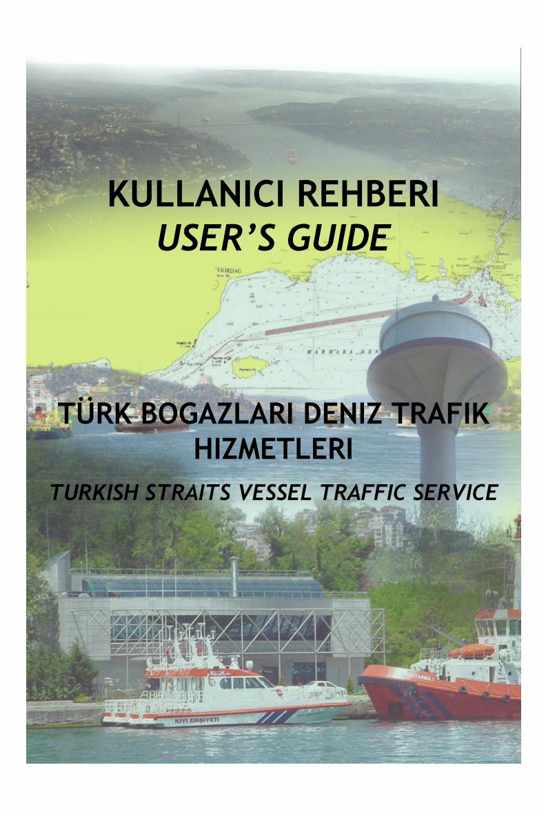
KULLANICI REHBERIUSER’S GUIDE
TÜRK BOGAZLARI DENIZ TRAFIK HIZMETLERI
TURKISH STRAITS VESSEL TRAFFIC SERVICE
TURKISH STRAITS
VESSEL TRAFFIC SERVICE
USER’S GUIDE
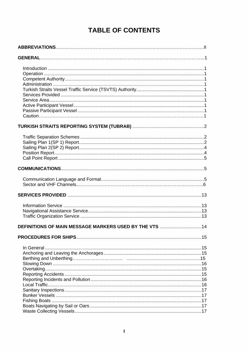
TABLE OF CONTENTS ABBREVIATIONS…………………………………………………………………………………….II GENERAL……………………………………………………………………………………………...1
Introduction ........................................................................................................................1 Operation ...........................................................................................................................1 Competent Authority...........................................................................................................1 Administration ....................................................................................................................1 Turkish Straits Vessel Traffic Service (TSVTS) Authority....................................................1 Services Provided ..............................................................................................................1 Service Area.......................................................................................................................1 Active Participant Vessel ....................................................................................................1 Passive Participant Vessel .................................................................................................1
Caution………………………………………………………………………………………………1 TURKISH STRAITS REPORTING SYSTEM (TUBRAB) .......................................................2
Traffic Separation Schemes ...............................................................................................2 Sailing Plan 1(SP 1) Report................................................................................................2 Sailing Plan 2(SP 2) Report................................................................................................4 Position Report...................................................................................................................4 Call Point Report ................................................................................................................5
COMMUNICATIONS..............................................................................................................5
Communication Language and Format...............................................................................5
Sector and VHF Channels...……………………………………………………………………...6 SERVICES PROVIDED .......................................................................................................13
Information Service ..........................................................................................................13 Navigational Assistance Service.......................................................................................13 Traffic Organization Service .............................................................................................13
DEFINITIONS OF MAIN MESSAGE MARKERS USED BY THE VTS ................................14 PROCEDURES FOR SHIPS................................................................................................15
In General ........................................................................................................................15 Anchoring and Leaving the Anchorages ...........................................................................15 Berthing and Unberthing…………………………… …………………………………………15 Slowing Down ..................................................................................................................16 Overtaking........................................................................................................................15 Reporting Accidents .........................................................................................................15 Reporting Incidents and Pollution .....................................................................................16 Local Traffic......................................................................................................................16 Sanitary Inspections .........................................................................................................17 Bunker Vessels ................................................................................................................17 Fishing Boats ...................................................................................................................17 Boats Navigating by Sail or Oars......................................................................................17 Waste Collecting Vessels .................................................................................................17
I
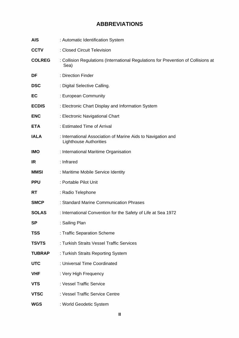
ABBREVIATIONS
AIS : Automatic Identification System
CCTV : Closed Circuit Television
COLREG : Collision Regulations (International Regulations for Prevention of Collisions at Sea)
DF : Direction Finder
DSC : Digital Selective Calling.
EC : European Community
ECDIS : Electronic Chart Display and Information System
ENC : Electronic Navigational Chart
ETA : Estimated Time of Arrival
IALA : International Association of Marine Aids to Navigation and
Lighthouse Authorities
IMO : International Maritime Organisation
IR : Infrared
MMSI : Maritime Mobile Service Identity
PPU : Portable Pilot Unit
RT : Radio Telephone
SMCP : Standard Marine Communication Phrases
SOLAS : International Convention for the Safety of Life at Sea 1972
SP : Sailing Plan
TSS : Traffic Separation Scheme
TSVTS : Turkish Straits Vessel Traffic Services
TUBRAP : Turkish Straits Reporting System
UTC : Universal Time Coordinated
VHF : Very High Frequency
VTS : Vessel Traffic Service
VTSC : Vessel Traffic Service Centre
WGS : World Geodetic System
II
1
GENERAL Introduction The Turkish Straits VTS has been established in accordance with applicable national laws and international rules and regulations in order to improve the safety of navigation, protection of life, environment, and property in the Turkish Straits by using the latest technology. This User’s Guide has been prepared to provide information related to the services provided, needed by the participant vessels that are navigating in the Turkish Straits. This User’s Guide aims to be used together with the Turkish Straits Maritime Traffic Regulations, as promulgated in the Official Gazette no.23515 of 6 November 1998. Operation The TSVTS shall be operated in accordance with the Turkish Straits Maritime Traffic Regulations, as promulgated in the Official Gazette no.23515 of 6 November 1998 together with the IMO Resolutions A.857 (20) and A.827 (19). Competent Authority Minister of Transport of the Republic of Turkey. Administration Undersecretariat for Maritime Affairs. TSVTS Authority The Director General for Coastal Safety and Salvage Administration. Services Provided The TSVTS, prepared taking into account related IALA resolutions and recommendations and in compliance with IMO Resolutions A.857(20) and A.827(19) provides the Information Service, Navigational Assistance Service and Traffic Organization Service. Service Area The TSVTS covers the area indicated in figures no. 1, 2, 3, 4, 5 and 6 (in the near future the Marmara Sea area will also be covered so that the entire area of the Turkish Straits will be included in the TSVTS service area). Active Participant Vessel Vessels carrying dangerous cargo and vessels 20 meters in length or over, whether in stopover or non-stopover passage through the Turkish Straits, for whatever purpose, shall be designated as “Active Participant” vessels within the TSVTS area and it is strongly recommended that Active Participant vessels comply with all the requirements of TUBRAP. Passive Participant Vessel Vessels less than 20 meters in length and local traffic vessels within the TSVTS area, for whatever purpose, shall be designated as “Passive Participant” vessels. Passive participants are not required to participate in TUBRAP. However, VHF frequency of the sector should be monitored at all times and all messages given by the TSVTS should be followed within the TSVTS Area. Caution Within the TSVTS system, an ENC, prepared based upon WGS 84 datum, is in service. Participants using charts of a different datum should make the necessary datum corrections for the positions given by the TSVTS in latitudes and longitudes.
2
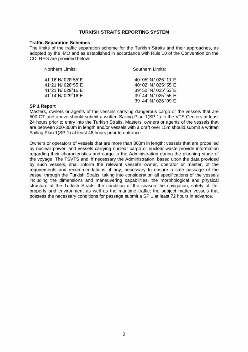
TURKISH STRAITS REPORTING SYSTEM Traffic Separation Schemes The limits of the traffic separation scheme for the Turkish Straits and their approaches, as adopted by the IMO and as established in accordance with Rule 10 of the Convention on the COLREG are provided below: Northern Limits: Southern Limits: 41o16´N/ 028o55´E 40o 05´ N / 026o 11´ E 41o21´N/ 028o55´E 40o 02´ N / 025o 55´ E 41o21´N/ 029o16´E 39o 50´ N / 025o 53´ E 41o14´N/ 029o16´E 39o 44´ N / 025o 55´ E 39o 44´ N / 026o 09´ E SP 1 Report Masters, owners or agents of the vessels carrying dangerous cargo or the vessels that are 500 GT and above should submit a written Sailing Plan 1(SP-1) to the VTS Centers at least 24 hours prior to entry into the Turkish Straits. Masters, owners or agents of the vessels that are between 200-300m in length and/or vessels with a draft over 15m should submit a written Sailing Plan 1(SP-1) at least 48 hours prior to entrance. Owners or operators of vessels that are more than 300m in length; vessels that are propelled by nuclear power; and vessels carrying nuclear cargo or nuclear waste provide information regarding their characteristics and cargo to the Administration during the planning stage of the voyage. The TSVTS and, if necessary the Administration, based upon the data provided by such vessels, shall inform the relevant vessel’s owner, operator or master, of the requirements and recommendations, if any, necessary to ensure a safe passage of the vessel through the Turkish Straits, taking into consideration all specifications of the vessels including the dimensions and maneuvering capabilities, the morphological and physical structure of the Turkish Straits, the condition of the season the navigation, safety of life, property and environment as well as the maritime traffic; the subject matter vessels that possess the necessary conditions for passage submit a SP 1 at least 72 hours in advance.
3
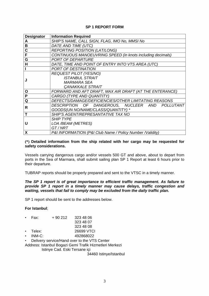
SP 1 REPORT FORM Designator Information Required A SHIP’S NAME, CALL SIGN, FLAG, IMO No, MMSI No B DATE AND TIME (UTC) C REPORTING POSITION (LAT/LONG) F CONTINUOUS MANOEUVRING SPEED (in knots including decimals) G PORT OF DEPARTURE H DATE, TIME AND POINT OF ENTRY INTO VTS AREA (UTC) I PORT OF DESTINATION
J
REQUEST PILOT (YES/NO) ISTANBUL STRAIT MARMARA SEA ÇANAKKALE STRAIT
O FORWARD AND AFT DRAFT, MAX AIR DRAFT (AT THE ENTERANCE) P CARGO (TYPE AND QUANTITY) Q DEFECTS/DAMAGE/DEFICIENCIES/OTHER LIMITATING REASONS
R DESCRIPTION OF DANGEROUS, NUCLEER AND POLLUTANT GOODS(UN NO/NAME/CLASS/QUANTITY) *
T SHIP’S AGENT/REPRESANTATIVE TAX NO
U SHIP TYPE LOA /BEAM (METRES) GT / NRT
X P&I INFORMATION (P&I Club Name / Policy Number /Validity)
(*) Detailed information from the ship related with her cargo may be requested for safety considerations.
Vessels carrying dangerous cargo and/or vessels 500 GT and above, about to depart from ports in the Sea of Marmara, shall submit sailing plan SP 1 Report at least 6 hours prior to their departure. TUBRAP reports should be properly prepared and sent to the VTSC in a timely manner. The SP 1 report is of great importance to efficient traffic management. As failure to provide SP 1 report in a timely manner may cause delays, traffic congestion and waiting, vessels that fail to comply may be excluded from the daily traffic plan.
SP 1 report should be sent to the addresses below. For Istanbul; • Fax: + 90 212 323 48 06
323 48 07 323 48 08 • Telex: 26699 VTCI • INM-C: 492868022 • Delivery service/Hand over to the VTS Center Address: Istanbul Bogazi Gemi Trafik Hizmetleri Merkezi Istinye Cad. Eski Tersane içi 34460 Istinye/Istanbul
4
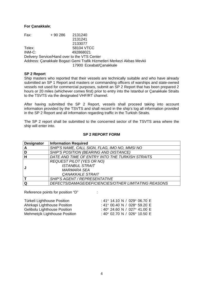
For Çanakkale; Fax: + 90 286 2131240
2131241 2133077 Telex: 58104 VTCC INM-C: 492868021 Delivery Service/Hand over to the VTS Center Address: Çanakkale Bogazi Gemi Trafik Hizmetleri Merkezi Akbas Mevkii 17900 Eceabat/Çanakkale SP 2 Report Ship masters who reported that their vessels are technically suitable and who have already submitted an SP 1 Report and masters or commanding officers of warships and state-owned vessels not used for commercial purposes, submit an SP 2 Report that has been prepared 2 hours or 20 miles (whichever comes first) prior to entry into the Istanbul or Çanakkale Straits to the TSVTS via the designated VHF/RT channel. After having submitted the SP 2 Report, vessels shall proceed taking into account information provided by the TSVTS and shall record in the ship’s log all information provided in the SP 2 Report and all information regarding traffic in the Turkish Straits.
The SP 2 report shall be submitted to the concerned sector of the TSVTS area where the ship will enter into.
SP 2 REPORT FORM Designator Information Required A SHIP’S NAME, CALL SIGN, FLAG, IMO NO, MMSI NO D SHIP’S POSITION (BEARING AND DISTANCE) H DATE AND TIME OF ENTRY INTO THE TURKISH STRAITS
J
REQUEST PILOT (YES OR NO) ISTANBUL STRAIT MARMARA SEA ÇANAKKALE STRAIT
T SHIP’S AGENT / REPRESENTATIVE Q DEFECTS/DAMAGE/DEFICIENCIES/OTHER LIMITATING REASONS Reference points for position “D” : Türkeli Lighthouse Position : 41° 14.10’ N / 029° 06.70’ E Ahirkapi Lighthouse Position : 41° 00.40’ N / 028° 59.20’ E Gelibolu Lighthouse Position : 40° 24.60’ N / 027° 41.00’ E Mehmetçik Lighthouse Position : 40° 02.70’ N / 026° 10.50’ E
5
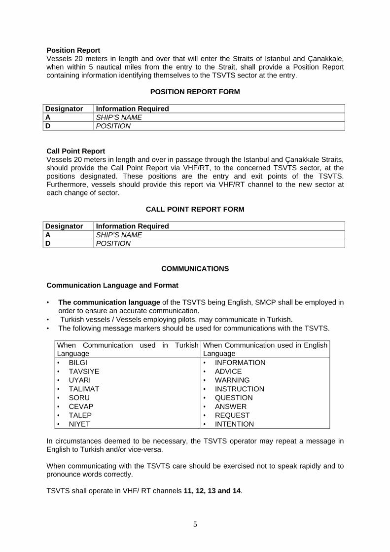
Position Report Vessels 20 meters in length and over that will enter the Straits of Istanbul and Çanakkale, when within 5 nautical miles from the entry to the Strait, shall provide a Position Report containing information identifying themselves to the TSVTS sector at the entry.
POSITION REPORT FORM
Designator Information Required A SHIP’S NAME D POSITION Call Point Report Vessels 20 meters in length and over in passage through the Istanbul and Çanakkale Straits, should provide the Call Point Report via VHF/RT, to the concerned TSVTS sector, at the positions designated. These positions are the entry and exit points of the TSVTS. Furthermore, vessels should provide this report via VHF/RT channel to the new sector at each change of sector.
CALL POINT REPORT FORM Designator Information Required A SHIP’S NAME D POSITION
COMMUNICATIONS
Communication Language and Format • The communication language of the TSVTS being English, SMCP shall be employed in
order to ensure an accurate communication. • Turkish vessels / Vessels employing pilots, may communicate in Turkish. • The following message markers should be used for communications with the TSVTS.
When Communication used in Turkish Language
When Communication used in English Language
• BILGI • TAVSIYE • UYARI • TALIMAT • SORU • CEVAP • TALEP • NIYET
• INFORMATION • ADVICE • WARNING • INSTRUCTION • QUESTION • ANSWER • REQUEST • INTENTION
In circumstances deemed to be necessary, the TSVTS operator may repeat a message in English to Turkish and/or vice-versa. When communicating with the TSVTS care should be exercised not to speak rapidly and to pronounce words correctly.
TSVTS shall operate in VHF/ RT channels 11, 12, 13 and 14.
6
“Except as related to safety of navigation all other communication on these channels is forbidden.”
The VTS operator of sector concerned is responsible for maintaining the proper communication procedures on the VHF channel of his/her sector and has the duty to report every misuse of the frequency to the Authorities. VHF 06 will be used for emergencies.
VHF 67 has been designated for meteorological purposes. However may be used for making general announcements by the TSVTS when needed. In principle, while inside the TSVTS area and as far as is practicable, there should be no communication between vessels; all communication shall be conducted through the TSVTS. Working channels should not be used outside of the TSVTS purpose.
Keeping in mind that the system provides ships positions and records all communications, all stations transmitting on VHF should refrain from unnecessary communications and maintain at all times proper communication discipline.
Sectors and VHF channels
VTS Sector Limits The sectors and corresponding VHF/RT working channels in the Istanbul Strait are in the following order from north to south.
SECTOR NAME WORKING CHANNELS CALL SIGN TÜRKELI VHF/RT CH 11 SECTOR TÜRKELI KAVAK VHF/RT CH 12 SECTOR KAVAK KANDILLI VHF/RT CH 13 SECTOR KANDILLI KADIKÖY VHF/RT CH 14 SECTOR KADIKÖY
7
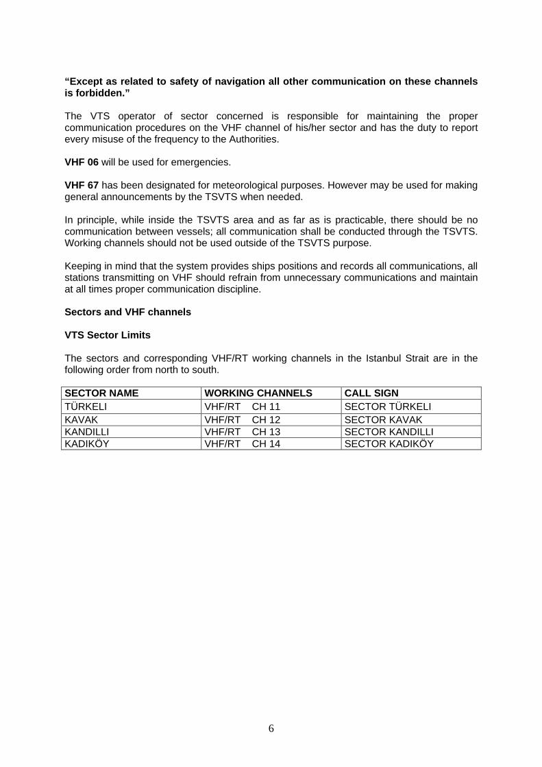
The northern limits of the Istanbul VTS are the line connecting the following positions.
A : 410 10.5’ N / 0290 35’ E B : 410 32.5’ N / 0290 35’ E C : 410 32.5’ N / 0280 45’ E D : 410 19’ N / 0280 45’ E
Figure 1
8
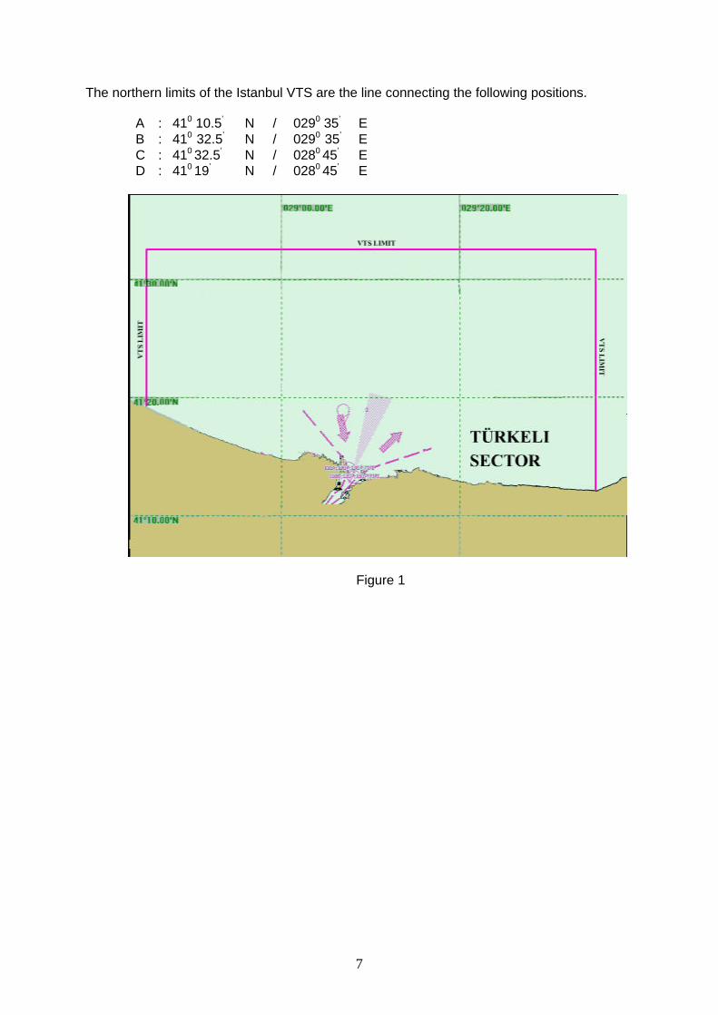
The southern limits of the Istanbul VTS are the lines connecting the following positions.
A : 400 53.1’ N / 0290 10.8’ E B : 400 52.4’ N / 0290 08.2’ E C : 400 50.3’ N / 0290 07.5’ E D : 400 45.2’ N / 0290 07.4’ E E : 400 49.1’ N / 0280 42.6’ E F : 400 57.3’ N / 0280 37.5’ E
Figure 2
9
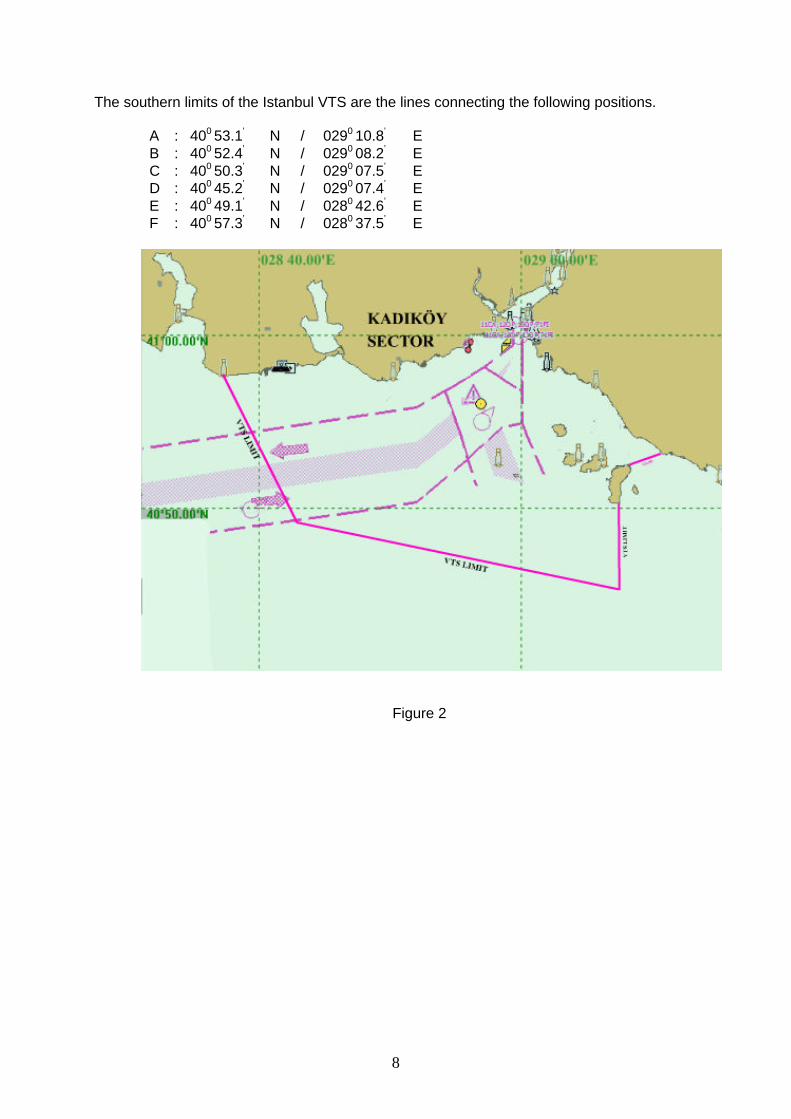
Sector Türkeli The northern limit of this sector is the northern limit of the Istanbul VTS. The southern limit is the line joining Fil Burnu Light at (410 12.4’ N / 290 07.13’ E) and Çali Burnu Light (410 12.43’ N / 290 06.37’ E) Sector Kavak The northern limit of this sector is the southern limit of sector Türkeli. The southern limit is the Fatih Sultan Mehmet Bridge. Sector Kandilli The northern limit of this sector is Fatih Sultan Mehmet Bridge. The southern limit of this sector is the line joining Haydarpasa Breakwater north end (410
00.6’ N / 0290 00.1’ E) and position ashore 410 00.6’ N / 280 59.23’ E including the Haydarpasa Port and Kadiköy Breakwater Sector Kadiköy The northern limit of this sector is the southern limit of Sector Kandilli. The southern limit of this sector is the southern limit of the Istanbul VTS.
Figure 3
10
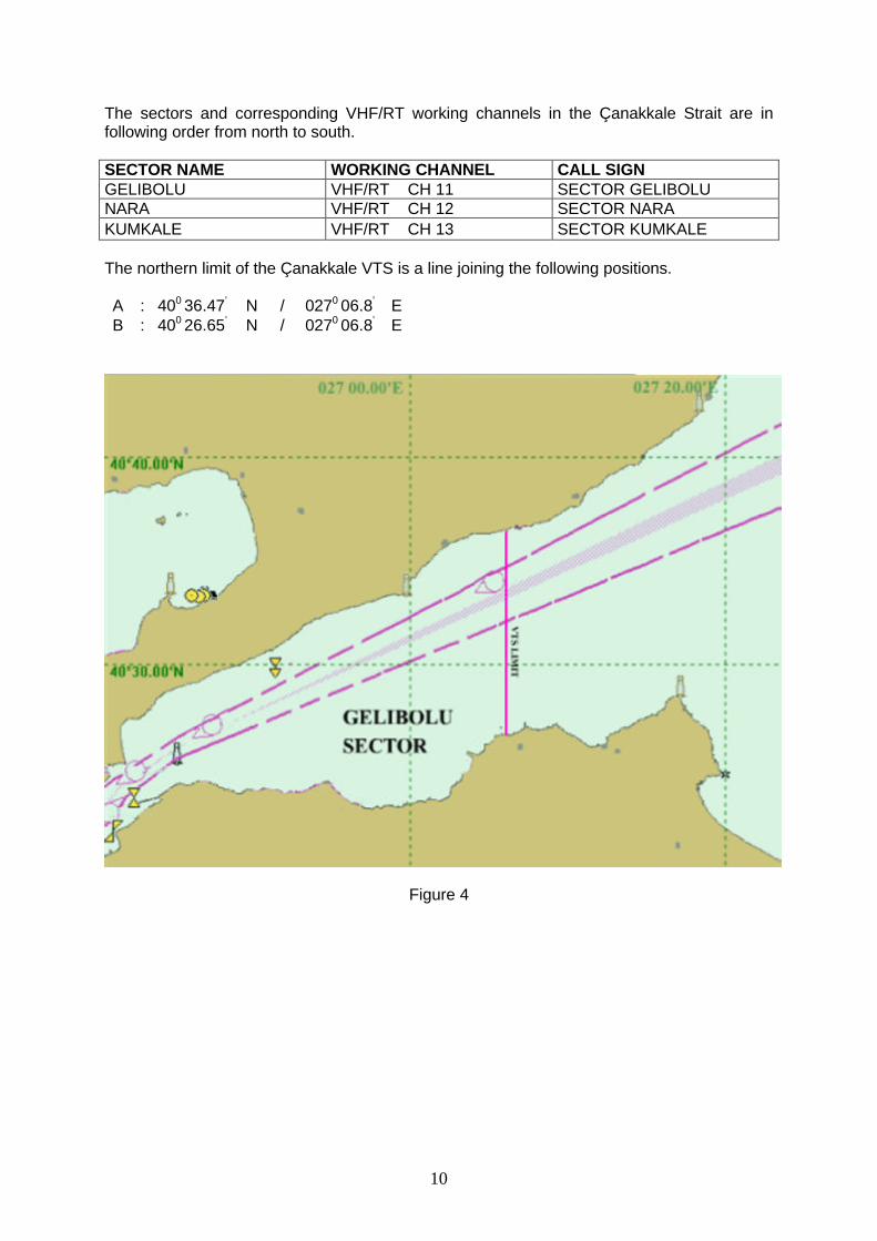
The sectors and corresponding VHF/RT working channels in the Çanakkale Strait are in following order from north to south. SECTOR NAME WORKING CHANNEL CALL SIGN GELIBOLU VHF/RT CH 11 SECTOR GELIBOLU NARA VHF/RT CH 12 SECTOR NARA KUMKALE VHF/RT CH 13 SECTOR KUMKALE The northern limit of the Çanakkale VTS is a line joining the following positions. A : 400 36.47’ N / 0270 06.8’ E B : 400 26.65’ N / 0270 06.8’ E
Figure 4
11
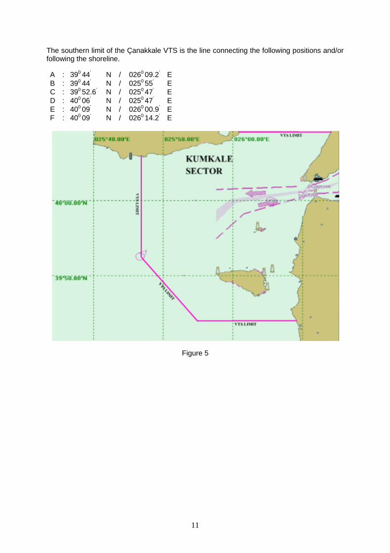
The southern limit of the Çanakkale VTS is the line connecting the following positions and/or following the shoreline. A : 390 44’ N / 0260 09.2’ E B : 390 44’ N / 0250 55’ E C : 390 52.6’ N / 0250 47’ E D : 400 06’ N / 0250 47’ E E : 400 09’ N / 0260 00.9’ E F : 400 09’ N / 0260 14.2’ E
Figure 5
12
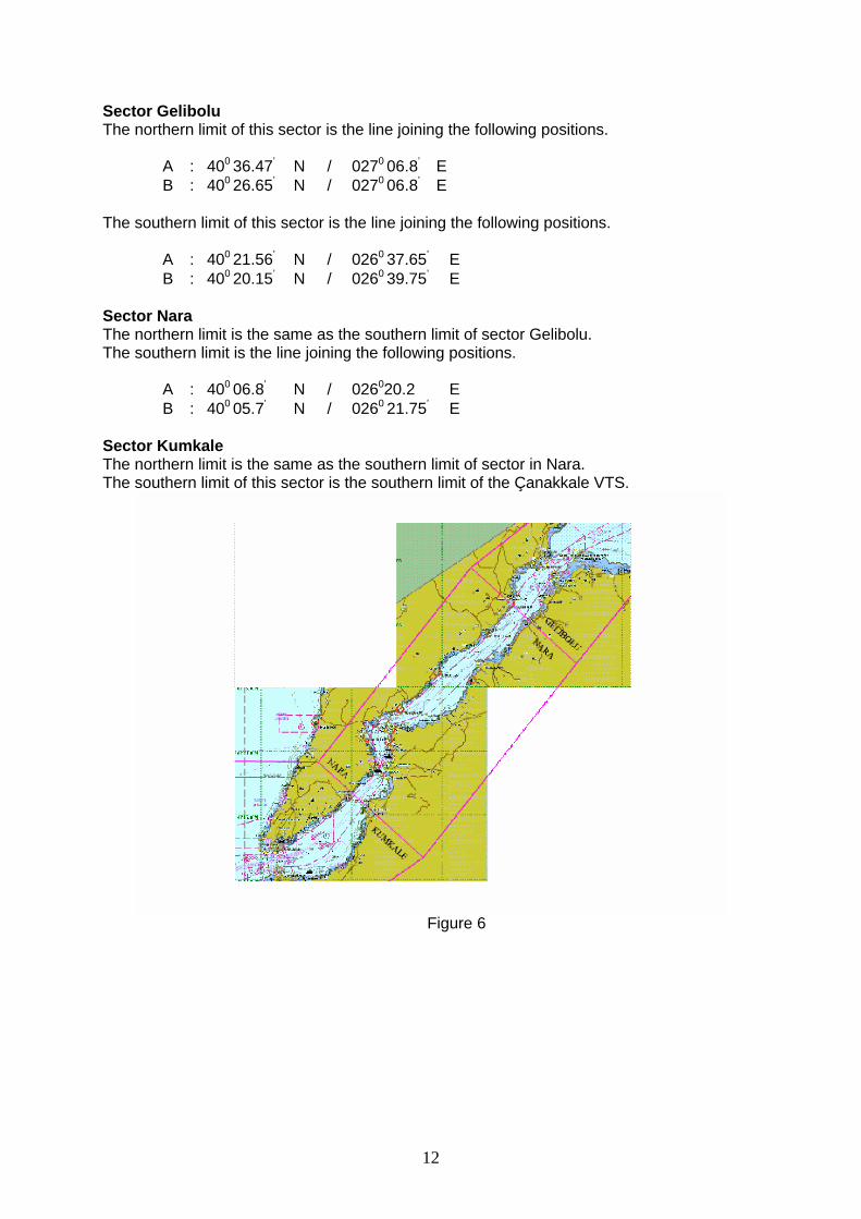
Sector Gelibolu The northern limit of this sector is the line joining the following positions.
A : 400 36.47’ N / 0270 06.8’ E B : 400 26.65’ N / 0270 06.8’ E
The southern limit of this sector is the line joining the following positions.
A : 400 21.56’ N / 0260 37.65’ E B : 400 20.15’ N / 0260 39.75’ E
Sector Nara The northern limit is the same as the southern limit of sector Gelibolu. The southern limit is the line joining the following positions.
A : 400 06.8’ N / 026020.2 E B : 400 05.7’ N / 0260 21.75’ E
Sector Kumkale The northern limit is the same as the southern limit of sector in Nara. The southern limit of this sector is the southern limit of the Çanakkale VTS.
Figure 6
13
SERVICES PROVIDED Marine Traffic in the TSVTS delineated area is monitored by using Radar, ENC, AIS, CCTV and VHF equipment such as VHF R/T, DSC and DF. TSVTS also receives information from various sources on anticipated vessel movements, hazards to navigation, aids to navigation and any other information of interests to TSVTS participants. Information Service • Marine Traffic information • Information about the position of a vessel in relation with other vessels • Information about positions of other vessels by means of distances from own vessel,
course and speed over the ground • Information about intended movements of other vessels • Notices to Mariners • Hydrological information • Meteorological information • Information about the reported status of aids to navigation • Any other information when deemed necessary by the TSVTS Navigational Assistance Service
Navigational Assistance Service will be provided when severe meteorological situations have been observed, deficiencies or breakdowns have occurred during the passage of the participants, when required by the master or the person in charge or, when deemed necessary by the TSVTS. With regard to the safety of navigation, decision making process on the bridge of the participant vessels may be assisted by providing the following information. • Position information in order to ensure safe navigation of vessels sailing within the TSS • Information about movements of other vessels in the vicinity • Warnings with regard to dangerous situations that might develop The beginning and ending time of the navigational assistance service must be clearly agreed and recorded by the Master and TSVTS operator Traffic Organization Service This service is constituted from the following items: • Vessel Sailing Plan and its entry permission, time and date to the Straits of Istanbul and
Çanakkale • Any changes to the Sailing Plan • Operational information before entering the Straits related to the traffic organization • Operational information based upon the Turkish Straits Maritime Traffic Regulations The SP 1 and SP 2 Reports constitute the primary sources for traffic organization service provided by the TSVTS. Timely and accurate reporting of SP 1 and SP 2 will increase the efficiency of traffic organization. Vessels that do not provide correct and timely information will disrupt the orderly flow of maritime traffic and may lead to delays as a result.
14
DEFINITIONS OF MAIN MESSAGE MARKERS USED BY THE VTS Information: The TSVTS analyses the information collected from different sources and distributes such data to participants according to their requests and needs. Information may be given by the TSVTS at regular intervals or as requested by the participants or when deemed necessary by the TSVTS. The purpose of informing participants is to facilitate the safe navigation of vessels and to assist the ship masters in taking decisions. Recommendation: TSVTS operators in charge, in order to prevent a potentially dangerous situation or when deemed necessary, may make recommendations to all participant vessels such as the taking of a pilot (for active participants only) or regarding maneuvers to be made. Such recommendations do not relieve the master or person in charge of his or her responsibility to navigate the vessel safely. Abiding by the recommendations is solely at the initiative of the master or the person in charge. However it must be kept in mind at all times that the Supervisors and the Operators of the TSVTS are former ocean-going shipmasters who have been properly trained and licensed in accordance with IALA criteria. Warning : TSVTS operators in charge will issue warnings to the participants when a potentially dangerous situation occurs or is observed to be developing. TSVTS, after issuing a warning, will monitor whether or not care had been exercised and action to prevent the accident or dangerous situation had been taken. Instruction: TSVTS may give instructions to all participant vessels upon the development of an imminent and unavoidable danger, the violation of safety rules and regulations, when a participant is not or does not seem to be aware of an imminent and obvious danger or in case of a warning is ignored by a participant vessel. Instructions given by the TSVTS shall always be result oriented, however all factors that affect navigation, such as the steering or engine orders shall at all times remain with the decision of those on board i.e. the master or pilot.
The TSVTS, while providing these services, shall at all times respect the master’s ultimate responsibility to control his/her vessel and shall exercise care not to interfere with the traditional master-pilot relationship.
Taking into consideration that all decisions concerning the safe navigation of a vessel shall be the sole responsibility of the master. Information, recommendations, warnings and instructions provided by the TSVTS to the participants with regard to safety of navigation shall at no time relieve the Master of his/her responsibility to manage his/her vessel and possess the requisite knowledge and responsibility. The TSVTS shall at no time be held responsible for decisions and actions taken by the Master.
15
PROCEDURES FOR SHIPS In General
• Submission of SP 1 and SP 2 reports to the TSVTS in accordance with the Turkish Straits Reporting system (TUBRAP).
• Call Point Reports shall be given during entry and exit of the TSVTS area and at the time of changing sectors.
• VHF R/T channel of the TSVTS Sector shall be listened to at all times during passage or anchorage when inside the TSVTS area.
• TSVTS should be informed at all times when vessels are leaving the TSVTS area. • Vessels navigating within the Turkish Straits, for safety of navigation, protection of life
and of the environment, should continuously monitor all TSVTS broadcasts and take heed of information, recommendations, warnings and instructions given by the TSVTS.
• Masters of vessels navigating within the Turkish Straits should report to the TSVTS all perils to safety of navigation observed.
• Vessels navigating within the TSS through the Marmara Sea, whether in stopover or non-stopover passage, in case of any deviation from the TSS, berthing or mooring to buoys, dropping anchor, turning back or emergencies and similar exceptional circumstances and any delays on their ETA’s exceeding 2 hours should report to the concerned VTSC.
• Vessels engaging in non-stopover passage through the Turkish Straits should hoist the signal flag “T” during the daytime and at night time exhibit a green light that can be observed from all points in the horizon, both during passage or while at anchor.
• All communications concerned with pilotage service should be performed via VHF R/T Channel 71.
For safety of navigation, protection of life and of the environment, pilotage is strongly recommended to all vessels intending to engage in non-stopover passage through the Turkish Straits. Anchoring and Leaving the Anchorages • Anchorage positions shall be determined by the TSVTS. • Anchored vessels should report to the TSVTS their anchorage position and time. • The concerned TSVTS sector channel should be continuously monitored at anchorage
areas. • Vessels should inform the TSVTS one hour prior to heave up their anchors. • When anchor has been heaved up, the vessel should notify the TSVTS of the time of
heaving up anchor, its port of destination and ETA, and obtain the necessary traffic information.
• Vessels engaging in non-stopover passage through the Turkish Straits, with the permission of the TSVTS, may anchor, up to 48 hours without having to obtain a “Free Pratique”.
Berthing and Unberthing • Vessels after berthing should notify the TSVTS Center. While moored in a port, it shall
not be required to listen to the sector channel. • Vessels should inform the TSVTS one hour prior to departing from the port and should
obtain permission for sailing from the TSVTS before single up. • Vessels leaving the pier, prior to entering traffic, should report their time of departure as
well as ETA to the TSVTS, and proceed while receiving traffic information.
16
Slowing Down Immediate notice should be given to the TSVTS Center when a vessel is forced to slow down in either the Istanbul or Çanakkale Strait. The TSVTS Center shall assess the traffic situation and provide information, recommendations and instructions regarding the situation. Overtaking Vessels shall not overtake another vessel unless there is an absolute necessity. In the case of such necessity, a vessel intending to overtake another shall inform the TSVTS Center prior to commencing the overtaking. The TSVTS Center shall assess the traffic situation and provide information, recommendations and instructions regarding the situation. Effort shall be made to overtake the vessel in a single maneuver.
However, overtaking shall not take place between Vaniköy and Kanlica in the Strait of Istanbul and between Nara and Kilitbahir in the Strait of Çanakkale. Reporting Accidents Upon the occurrence of an accident inside the TSVTS area, both the vessel(s) involved in the accident and the witnessing vessel(s) should immediately notify the TSVTS sector. The TSVTS, is the first contact point for reporting accidents, so that the necessary precautions can be taken to minimize any actual or potential casualties, loss of lives and property and for the protection of the environment. The TSVTS will notify the appropriate authorities of such reports or notices. Reporting Incidents and Pollution Vessels should immediately notify the TSVTS Center of any incident occurring within the TSVTS that may interfere with the capability of vessels to safely maneuver or that creates a danger to the marine environment or the surrounding areas, so that the necessary precautions may be taken in a timely manner. Local Traffic Ferries, intra-city passenger vessels, fast ferries, passenger boats engaged in regular voyages, pleasure crafts, fishing boats, agent boats, government vessels, tug boats, vessels belonging to non-governmental organizations, vessels engage underwater operations and survey vessels and all other similar vessels constitute local traffic.
Local traffic vessels, whether or not they are subject to SOLAS requirements, are under a duty to monitor VHF R/T frequency and to follow the instructions issued by the TSVTS sector in which they are located.
Local traffic vessels inside the Turkish Straits proceeding, according to COLREG, shall cross the TSS by the shortest route available, keep out of the way of vessels navigating within the TSS and not impede the passage of these ships.
Non-complying vessels should be reported to the TSVTS Center. Sanitary Inspections Vessels that will pass through the Turkish Straits shall be subject to Sanitary Inspections in accordance with the 1936 Montreux Convention, at the positions as requested by the Turkish Straits Maritime Regulations.
17
Bunker Vessels Bunkering operations are carried out by informing the related TSVTS center and independently of TSS.
• After getting alongside the vessel to be served, a report containing the following information should be provided to the TSVTS Center:
- Name of the bunker vessel - Name of the vessel being bunkered - Time alongside
• After completion of bunkering operations a report containing the following information
should be provided to the TSVTS Center :
- Type and quantity of bunker supplied - Cast off time
• TSVTS will add this information to the database • TSVTS will inform vessels maneuvering in the area of the bunkering operations. • Any leakage or spillage should be immediately reported to the TSVTS Center so that
the necessary precautions can be taken. Fishing Boats No fishing vessel, regardless of its length, may engage in any fishing activities while inside the TSS. While outside of the TSS fishing vessels should maintain utmost care not to impede the passage of other vessels. Boats navigating by sail or oars Navigating by sail or oars, swimming and hunting in the Turkish Straits TSS is prohibited. However, sailing, rowing and swimming competitions conducted for sporting purposes, and processions and special shows are subject to the permission and regulation of the Administration. Waste Collecting Vessels Waste reception operations are carried out by informing the related TSVTS center and independently of TSS.
• After getting alongside the vessel to be served, a report containing the following information should be provided to the TSVTS Center:
- Name of the waste collecting vessel - Name of the vessel being served - Time of alongside
• After completion of the operations a report containing the following information should
be provided to the TSVTS : - Type and quantity of waste collected - Cast of time
• TSVTS will add this information to the database • TSVTS will inform vessels maneuvering in the area of the waste collecting
operations. • Any leakage or spillage should be immediately reported to the TSVTS Center so that
the necessary precautions can be taken.
Kiyi Emniyeti ve Gemi Kurtarma Isletmeleri Genel MüdürlügüGeneral Management of Coastal Safety & Salvage Administrations
Meclis-i Mebusan Cd. No:18 Salipazari IstanbulTel: (+90) 0 212 292 5280 Faks: (+90) 0 212 252 1787


![Pressure Vessel [Design]](https://img.pdfslide.tips/doc/110x75/546b26fcb4af9f000e8b4629/pressure-vessel-design-5584556ceffe5.jpg)